Oregon Territory

Last updated

Territory of Oregon
Organized incorporated territory of the United States
1846–1859
Oregon-Territory-seal.tif
Seal of the Oregon Territory
Capital
Government
  Type Organized incorporated territory
   Motto Alis volat propriis
Governor  
 1848–1850; 1853
Joseph Lane
 1850
Kintzing Prichette
 1850–1853
John P. Gaines
 1853–1854
John W. Davis
 1854–1859
George L. Curry
History 
June 15, 1846
 Organized
August 14 1846
  Washington Territory split off
March 2, 1853
  Statehood
February 14, 1859 1859
Preceded by
Succeeded by
US flag 29 stars.svg Provisional Government of Oregon
Washington Territory Flag of the United States (1851-1858).svg
Oregon Flag of Oregon.svg

The Territory of Oregon was an organized incorporated territory of the United States that existed from August 14, 1848, [1] until February 14, 1859, when the southwestern portion of the territory was admitted to the Union as the State of Oregon. Originally claimed by several countries (see Oregon Country), Spanish "El Orejón" was part of the Territorio de Nutca (1789–1795), later in the 19th century, the region was divided between the British Empire and the US in 1846. When established, the territory encompassed an area that included the current states of Oregon, Washington, and Idaho, as well as parts of Wyoming and Montana. The capital of the territory was first Oregon City, then Salem, followed briefly by Corvallis, then back to Salem, which became the state capital upon Oregon's admission to the Union.

Contents

Background

Originally inhabited by Native Americans, the region that became the Oregon Territory was explored by Europeans first by sea. The first documented voyage of exploration was made in 1777 by the Spanish, and both British and American vessels visited the region not long thereafter. [2] [3] Subsequent land-based exploration by Alexander Mackenzie and the Lewis and Clark Expedition and development of the fur trade in the region strengthened the competing claims of Great Britain and the United States. [4]

The competing interests of the two foremost claimants were addressed in the Treaty of 1818, which sanctioned a "joint occupation", by British and Americans, of a vast "Oregon Country" (as the American side called it) that comprised the present-day U.S. states of Oregon, Washington, and Idaho, parts of Montana and Wyoming, and the portion of what is now the Canadian province of British Columbia south of the parallel 54°40′ north. [5]

Formation

The Oregon Territory, as originally organized, in 1848 Wpdms oregon territory 1848.png
The Oregon Territory, as originally organized, in 1848
The Oregon Territory (blue) with the Washington Territory (green) in 1853 Wpdms oregon washington territories 1853.png
The Oregon Territory (blue) with the Washington Territory (green) in 1853
The State of Oregon (blue) with the Washington Territory (green) in 1859 Wpdms oregon washington territory 1859.png
The State of Oregon (blue) with the Washington Territory (green) in 1859

During the period of joint occupation, most activity in the region outside of the activities of the indigenous people came from the fur trade, which was dominated by the British Hudson's Bay Company. [6] Over time, some trappers began to settle down in the area and began farming, and missionaries started to arrive in the 1830s. [6] Some settlers also began arriving in the late 1830s, and covered wagons crossed the Oregon Trail beginning in 1841. [7] At that time, the only governments that existed in the Oregon Country were the individual local Native Americans communities, as no one nation held dominion over the territory.

A group of settlers in the Willamette Valley began meeting in 1841 to discuss organizing a government for the area. [8] These earliest documented discussions, mostly concerning forming a government, were held in an early pioneer and Native American encampment and later town known as Champoeg, Oregon. [8] These first Champoeg Meetings eventually led to further discussions, and in 1843 the creation of the Provisional Government of Oregon. [8] In 1846, the Oregon boundary dispute between the U.S. and Britain was settled with the signing of the Oregon Treaty. [5]

The United States federal government left their part of the region unorganized for two years until news of the Whitman massacre reached the United States Congress and helped to facilitate the organization of the region into a U.S. territory. [9] On August 14, 1848, Congress passed the Act to Establish the Territorial Government of Oregon, which created what was officially the Territory of Oregon. [9] The Territory of Oregon originally encompassed all of the present-day states of Idaho, Oregon and Washington, as well as those parts of present-day Montana and Wyoming west of the Continental Divide. [9] Its southern border was the 42nd parallel north (the boundary of the Adams-Onis Treaty of 1819), and it extended north to the 49th parallel. Oregon City, Oregon, was designated as the first capital. [10]

Government

The territorial government consisted of a governor, a marshal, a secretary, an attorney, and a three-judge supreme court. [9] Judges on the court also sat as trial level judges as they rode circuit across the territory. [9] All of these offices were filled by appointment by the President of the United States. [9] The two-chamber Oregon Territorial Legislature was responsible for passing laws, with seats in both the upper-chamber council and lower-chamber house of representatives filled by local elections held each year. [9]

Taxation took the form of an annual property tax of 0.25% for territorial purposes with an additional county tax not to exceed this amount. [11] This tax was to be paid on all town lots and improvements, mills, carriages, clocks and watches, and livestock; farmland and farm products were not taxed. [11] In addition, a poll tax of 50 cents for every qualified voter under age 60 was assessed and a graduated schedule of merchants' licenses established, ranging from the peddlar's rate of $10 per year to a $60 annual fee on firms with more than $20,000 of capital. [11]

Gaining statehood

Oregon City served as the seat of government from 1848 to 1851, followed by Salem from 1851 to 1855. Corvallis served briefly as the capital in 1855, followed by a permanent return to Salem later that year. [12] In 1853, as a result of the Monticello Convention and its approval by Congress and President Millard Fillmore, the portion of the territory north of the lower Columbia River and north of the 46th parallel east of the river was organized into the Washington Territory. [13] [14] The Oregon Constitutional Convention was held in 1857 to draft a constitution in preparation for becoming a state, with the convention delegates approving the document in September, and then general populace approving the document in November. [15]

In 1850, 10 years after the end of the Second Great Awakening (1790–1840), of the 9 churches with regular services in the Oregon Territory, 5 were Catholic, 1 was Baptist, 1 was Congregational, 1 was Methodist, and 1 was Presbyterian. [16] In the 1850 United States census, 10 counties in the Oregon Territory (7 counties in contemporary Oregon and 3 in contemporary Washington) reported the following population counts: [17] [18]

RankCountyPopulation
1 Marion 2,749
2 Washington 2,652
3 Clackamas 1,859
4 Yamhill 1,512
5 Polk 1,051
6 Linn 994
7 Benton 814
8 Clark 643
9 Lewis 558
10 Clatsop 462
Oregon Territory13,294

On February 14, 1859, the territory entered the Union as the U.S. state of Oregon within its current boundaries. [15] The remaining eastern portion of the territory (the portions in present-day southern Idaho and western Wyoming) was added to the Washington Territory.

See also

Related Research Articles

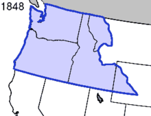
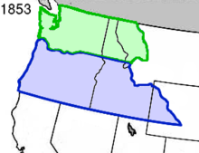
The Territory of Washington was an organized incorporated territory of the United States that existed from March 2, 1853, until November 11, 1889, when the territory was admitted to the Union as the State of Washington. It was created from the portion of the Oregon Territory north of the lower Columbia River and north of the 46th parallel east of the Columbia. At its largest extent, it also included the entirety of modern Idaho and parts of Montana and Wyoming, before attaining its final boundaries in 1863.

<span class="mw-page-title-main">Wyoming Territory</span> Former organized incorporated territory of the United States (1868–1890)

The Territory of Wyoming was an organized incorporated territory of the United States that existed from July 25, 1868, until July 10, 1890, when it was admitted to the Union as the State of Wyoming. Cheyenne was the territorial capital. The boundaries of the Wyoming Territory were identical to those of the modern State of Wyoming.

<span class="mw-page-title-main">Idaho Territory</span> Territory of the U.S. between 1863–1890

The Territory of Idaho was an organized incorporated territory of the United States that existed from March 3, 1863, until July 3, 1890, when the final extent of the territory was admitted to the Union as Idaho.

<span class="mw-page-title-main">Missouri Territory</span> Territory of the United States of America from 1812 to 1821

The Territory of Missouri was an organized incorporated territory of the United States that existed from June 4, 1812, until August 10, 1821. In 1819, the Territory of Arkansas was created from a portion of its southern area. In 1821, a southeastern portion of the territory was admitted to the Union as the State of Missouri, and the rest became unorganized territory for several years.

<span class="mw-page-title-main">Historical regions of the United States</span>

The territory of the United States and its overseas possessions has evolved over time, from the colonial era to the present day. It includes formally organized territories, proposed and failed states, unrecognized breakaway states, international and interstate purchases, cessions, and land grants, and historical military departments and administrative districts. The last section lists informal regions from American vernacular geography known by popular nicknames and linked by geographical, cultural, or economic similarities, some of which are still in use today.

<span class="mw-page-title-main">Joseph Meek</span> American pioneer, mountain man, law enforcement official, and politician(1810–1875)

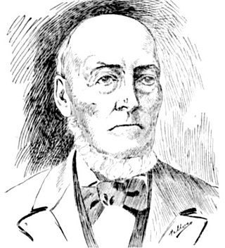
Joseph Lafayette Meek was an American pioneer, mountain man, law enforcement official, and politician in the Oregon Country and later Oregon Territory of the United States. A trapper involved in the fur trade before settling in the Tualatin Valley, Meek played a prominent role at the Champoeg Meetings of 1843, where he was elected a sheriff. He was later elected to and served in the Provisional Legislature of Oregon before being appointed as the United States Marshal for the Oregon Territory.

<span class="mw-page-title-main">Northwestern United States</span> Geographical region of the United States

The Northwestern United States, also known as the American Northwest or simply the Northwest, is an informal geographic region of the United States. The region consistently includes the states of Oregon, Washington, Idaho, Montana and Wyoming. Some sources include Southeast Alaska in the Northwest. The related but distinct term "Pacific Northwest" generally excludes areas from the Rockies eastward, whereas the term "Inland Northwest" excludes areas west of the Cascades.

<span class="mw-page-title-main">Oregon pioneer history</span> Account of the founders Oregon

Oregon pioneer history (1806–1890) is the period in the history of Oregon Country and Oregon Territory, in the present day state of Oregon and Northwestern United States.

William J. Bailey was a British-born physician who migrated to the United States, where he became a pioneer and politician in the Oregon Country, particularly the Willamette Valley. Bailey participated in the Champoeg Meetings that led to the creation of a provisional government in Oregon. He was selected as a member of that government, first on the executive committee and later in the Provisional Legislature of Oregon.

<span class="mw-page-title-main">Provisional Government of Oregon</span> Early elected government of Pacific Northwest, 1843–1849

The Provisional Government of Oregon was a popularly elected settler government created in the Oregon Country, in the Pacific Northwest region of North America. Its formation had been advanced at the Champoeg Meetings since February 17, 1841, and it existed from May 2, 1843 until March 3, 1849, and provided a legal system and a common defense amongst the mostly American pioneers settling an area then inhabited by the many Indigenous Nations. Much of the region's geography and many of the Natives were not known by people of European descent until several exploratory tours were authorized at the turn of the 18th and 19th centuries. The Organic Laws of Oregon were adopted in 1843 with its preamble stating that settlers only agreed to the laws "until such time as the United States of America extend their jurisdiction over us". According to a message from the government in 1844, the rising settler population was beginning to flourish among the "savages", who were "the chief obstruction to the entrance of civilization" in a land of "ignorance and idolatry".

Historic ferries in Oregon are water transport ferries that operated in Oregon Country, Oregon Territory, and the state of Oregon, United States. These ferries allowed people to cross bodies of water, mainly rivers such as the Willamette in the Willamette Valley, and the Columbia, in order to transport goods, move people, and further communications until permanent bridges were built to allow faster crossing of the water. The early ferries were used by wagons and pedestrians, while later ones transported trains and then automobiles. Oregon has a few automobile ferries still in operation.

<span class="mw-page-title-main">William H. Willson</span> American politician

William Holden Willson was a pioneer of the U.S. state of Oregon and the founder of its capital city, Salem. A native of New Hampshire, he immigrated to the Oregon Country in 1837 to work at the Methodist Mission, and there would participate in the Champoeg Meetings. Willson served as the first treasurer of the Provisional Government of Oregon.

<span class="mw-page-title-main">Provisional Legislature of Oregon</span> Early Oregon legislature

The Provisional Legislature of Oregon was the single-chamber legislative body of the Provisional Government of Oregon. It served the Oregon Country of the Pacific Northwest of North America from 1843 until early 1849 at a time when no country had sovereignty over the region. This democratically elected legislature became the Oregon Territorial Legislature when the territorial authorities arrived after the creation of the Oregon Territory by the United States in 1848. The body was first termed the Legislative Committee and later renamed the House of Representatives. Over the course of its six-year history the legislature passed laws, including taxation and liquor regulation, and created an army to deal with conflicts with Native Americans.

<span class="mw-page-title-main">Oregon Territorial Legislature</span> A defunct legislative body by the United States Congress

Oregon's Territorial Legislature was a bicameral legislative body created by the United States Congress in 1848 as the legislative branch of the government of the Oregon Territory. The upper chamber Council and lower chamber House of Representatives first met in July 1849; they served as the region's legislative body until Oregon became a state in February 1859, when they were replaced by the bicameral Oregon State Legislature.

<span class="mw-page-title-main">Organic Laws of Oregon</span>

The Organic Laws of Oregon were two sets of legislation passed in the 1840s by a group of primarily American settlers based in the Willamette Valley. These laws were drafted after the Champoeg Meetings and created the structure of a government in the Oregon Country. At the last Champoeg Meeting in May 1843, the majority voted to create what became the Provisional Government of Oregon. Laws were drafted by the committee and accepted by a popular vote in July. These laws were reformed by a second version in 1845.

<span class="mw-page-title-main">John Smith Griffin</span> American missionary

John Smith Griffin (1807–1899) was an American missionary in Oregon Country who participated at the Champoeg Meetings that created the Provisional Government of Oregon in 1843. In Oregon he served as a tutor at Fort Vancouver and later organized a church on the Tualatin Plains in the Tualatin Valley.

<span class="mw-page-title-main">Robert Newell (politician)</span> American politician and fur trapper

Robert "Doc" Newell was an American politician and fur trapper in the Oregon Country. He was a frontier doctor in what would become the U.S. state of Oregon. A native of Ohio, he served in the Provisional Government of Oregon and later was a member of the Oregon State Legislature. The Newell House Museum, his reconstructed former home on the French Prairie in Champoeg, is listed on the National Register of Historic Places.

<span class="mw-page-title-main">Outline of Wyoming territorial evolution</span>

The following outline traces the territorial evolution of the U.S. State of Wyoming.

<span class="mw-page-title-main">Territorial evolution of Idaho</span> A US state

The following chronology traces the territorial evolution of the U.S. State of Idaho.

<span class="mw-page-title-main">Territorial evolution of North America since 1763</span> Timeline of notable events

The 1763 Treaty of Paris ended the major war known by Americans as the French and Indian War and by Canadians as the Seven Years' War / Guerre de Sept Ans, or by French-Canadians, La Guerre de la Conquête. It was signed by Great Britain, France and Spain, with Portugal in agreement. Preferring to keep Guadeloupe, France gave up Canada and all of its claims to territory east of the Mississippi River to Britain. With France out of North America this dramatically changed the European political scene on the continent.

References

  1. 9  Stat.   323
  2. Howard M. Corning, ed. (1989). Dictionary of Oregon History. Binfords & Mort Publishing. p. 110.
  3. Horner, John B. (1919). Oregon: Her History, Her Great Men, Her Literature. The J.K. Gill Co.: Portland. pp. 28–29.
  4. Horner, pp. 53–59.
  5. 1 2 Corning, p. 129.
  6. 1 2 Horner, pp. 60–64.
  7. Corning, p. 186.
  8. 1 2 3 Corning, p. 206.
  9. 1 2 3 4 5 6 7 Corning, p. 240.
  10. Writers' Program of the Work Projects Administration in the State of Oregon (1940). Oregon: End of the Trail. American Guide Series. Portland, Oregon: Binfords & Mort. p.  191. OCLC   4874569.
  11. 1 2 3 Bancroft, Hubert Howe (1886). "Ch. 19"  . The Works of Hubert Howe Bancroft: Volume 29: History of Oregon: Volume 1, 1834-1848. San Francisco: The History Company. p. 540.
  12. Horner, p. 162.
  13. The History of the Pacific Northwest Oregon and Washington 1889: Volume I. Portland: North Pacific History Company. 1889.
  14. Horner, p. 153.
  15. 1 2 Horner, p. 166.
  16. Selcer, Richard F. (2006). Balkin, Richard (ed.). Civil War America: 1850 to 1875. New York: Facts on File. p. 143. ISBN   978-0816038671.
  17. Forstall, Richard L. (ed.). Population of the States and Counties of the United States: 1790–1990 (PDF) (Report). United States Census Bureau. pp. 134–135. Retrieved May 18, 2020.
  18. Forstall, Richard L. (ed.). Population of the States and Counties of the United States: 1790–1990 (PDF) (Report). United States Census Bureau. pp. 176–177. Retrieved May 18, 2020.

45°30′N117°00′W / 45.5°N 117°W / 45.5; -117