On April 10, 1805, the Territorial Legislature organized 12 counties (starting from the southeast corner moving west and north): Orleans County, LaFourche County, German Coast, Acadia County, Iberville County, Attakapas County, Pointe Coupée County, Opelousas County, Rapides County, Concordia County, Natchitoches County, and Ouachita County.
The area that later became the Florida Parishes on the east side of the Mississippi River was not included in Orleans Territory at this time, as it was in the Spanish territory of West Florida. This area was formally appended to the territory on April 14, 1812,[5] after having been annexed forcibly by the U.S. in 1810, although Spain did not formally relinquish any of West Florida until 1821. The western boundary with Spanish Texas was not fully defined until the Adams–Onís Treaty was negotiated in 1819. A strip of land known as the Sabine Free State just east of the Sabine River served as a neutral ground buffer area from about 1807 until the treaty took effect after ratification in 1821.
The Orleans Territory was the site of the largest slave revolt in American history, the 1811 German Coast Uprising.
Colonial map showing territorial border on the Ouachita RIver
Leaders and representatives
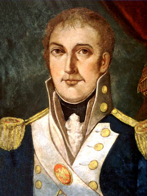
William C. C. Claiborne was appointed Governor of the Orleans Territory; he held this position throughout the territorial period. Later he became the first Governor of the state of Louisiana.
↑ William C. C. Claiborne (December 2, 1804). "Letter to Thomas Jefferson". National Archives. Retrieved October 23, 2021.
Further reading
Julien Vernet, Strangers on Their Native Soil: Opposition to United States' Governance in Louisiana's Orleans Territory, 1803–1809. Jackson, MS: University Press of Mississippi, 2013.[ISBNmissing]
The Territory of Louisiana or Louisiana Territory was an organized incorporated territory of the United States that existed from July 4, 1805, until June 4, 1812, when it was renamed the Missouri Territory. The territory was formed out of the District of Louisiana, which consisted of the portion of the Louisiana Purchase north of the 33rd parallel.
West Florida was a region on the northern coast of the Gulf of Mexico that underwent several boundary and sovereignty changes during its history. As its name suggests, it was formed out of the western part of former Spanish Florida, along with lands taken from French Louisiana; Pensacola became West Florida's capital. The colony included about two thirds of what is now the Florida Panhandle, as well as parts of the modern U.S. states of Louisiana, Mississippi, and Alabama.
Daniel Clark was the first Delegate from the Territory of Orleans to the United States House of Representatives. Born in Sligo, Ireland, he was reportedly educated at Eton College in England.
The District of Louisiana, or Louisiana District, was an official and temporary United States government designation for the portion of the Louisiana Purchase that had not been organized into the Territory of Orleans or "Orleans Territory". The district officially existed from March 10, 1804, until July 4, 1805, when it was organized as the Louisiana Territory.
The Indiana Territory, officially the Territory of Indiana, was created by an organic act that President John Adams signed into law on May 7, 1800, to form an organized incorporated territory of the United States that existed from July 4, 1800, to December 11, 1816, when the remaining southeastern portion of the territory was admitted to the Union as the state of Indiana. The territory originally contained approximately 259,824 square miles (672,940 km2) of land, but its size was decreased when it was subdivided to create the Michigan Territory (1805) and the Illinois Territory (1809). The Indiana Territory was the first new territory created from lands of the Northwest Territory, which had been organized under the terms of the Northwest Ordinance of 1787. The territorial capital was the settlement around the old French fort of Vincennes on the Wabash River, until transferred to Corydon near the Ohio River in 1813.
The Territory of Mississippi was an organized incorporated territory of the United States that was created under an organic act signed into law by President John Adams on April 7, 1798, and was dissolved on December 10, 1817, when the western half of the territory was admitted to the Union as the State of Mississippi. The eastern half was redesignated as the Alabama Territory until it was admitted to the Union as the State of Alabama on December 14, 1819. The Chattahoochee River played a significant role in the definition of the territory's borders. The population rose in the early 1800s from settlement, with cotton being an important cash crop.
William Charles Cole Claiborne was an American politician, best known as the first non-colonial governor of Louisiana. He also has the distinction of possibly being the youngest member of the United States Congress in U.S. history, although reliable sources differ about his age.
Return Jonathan Meigs Jr. was a Democratic-Republican politician from Ohio. He served as the fourth governor of Ohio, fifth United States Postmaster General, and as a United States senator.
The Neutral Ground was a disputed area between Spanish Texas and the United States' newly acquired Louisiana Purchase. Local officers of Spain and the United States agreed to leave the Neutral Ground temporarily outside the jurisdiction of either country. The area, now in western Louisiana, had neutral status from 1806 to 1821.
The Republic of West Florida, officially the State of Florida, was a short-lived republic in the western region of Spanish West Florida for just over 2+1⁄2 months during 1810. It was annexed and occupied by the United States later in 1810; it subsequently became part of Eastern Louisiana.
The West Florida Controversy included two border disputes that involved Spain and the United States in relation to the region known as West Florida over a period of 37 years. The first dispute commenced immediately after Spain received the colonies of West and East Florida from the Kingdom of Great Britain following the American Revolutionary War. Initial disagreements were settled with Pinckney's Treaty of 1795.
James Pitot (1761–1831), also known as Jacques Pitot, was the third Mayor of New Orleans, after Cavelier Petit served for a ten-day interim following Mayor Boré's resignation. Because he had already attained American citizenship, he is sometimes called New Orleans' first American mayor.
The Supreme Court of Louisiana is the highest court and court of last resort in the U.S. state of Louisiana. The modern Supreme Court, composed of seven justices, meets in the French Quarter of New Orleans.
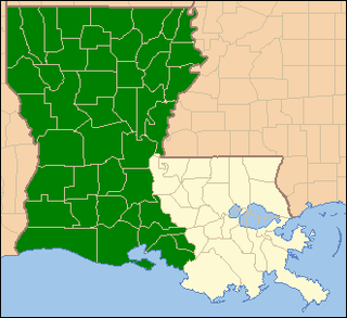
The United States District Court for the Western District of Louisiana is a United States federal court with jurisdiction over approximately two thirds of the state of Louisiana, with courts in Alexandria, Lafayette, Lake Charles, Monroe, and Shreveport. These cities comprise the Western District of Louisiana.
The following outline is provided as an overview of and topical guide to the U.S. state of Louisiana:
Joshua Lewis was a judge of the Superior Court of the Territory of Orleans and, after Louisiana became a state, the 1st Judicial District Court of that state.
The United States Court of Appeals for the Fifth Circuit has held that there is no aboriginal title in Louisiana.
Simon Favre was an interpreter of the Muskogean languages, particularly Choctaw and Chickasaw, for the French, British, Spanish and Americans in the part of West Florida that became part of the states of Mississippi and Alabama. The son of another prominent interpreter, Favre spent the late 18th century in the vicinity of Mobile and the Tombigbee River, which changed hands from French to British, and then Spanish control. He became well versed in the language and culture of the Choctaws, and was involved with several treaties between the Europeans and natives. As a young man he had a Choctaw mistress with whom he had six known children, then at the age of 41 he was legally married in Mobile to a woman of European descent. Within a few years of his marriage, he moved with his new family from the Tombigbee area to a plantation on the Pearl River.
The Mobile Act was the popular name of a bill signed into law in early 1804 by United States President Thomas Jefferson. The law defined revenue boundaries for the newly acquired territories that the United States had gained from its purchase of La Louisiane from France. The act anticipated that Mobile would be designated as a port of entry for a new revenue district. Mobile was, however, at the time a part of the Spanish province of West Florida.
This page is based on this Wikipedia article Text is available under the CC BY-SA 4.0 license; additional terms may apply. Images, videos and audio are available under their respective licenses.