Lincoln Parish, Louisiana

Last updated

Lincoln Parish, Louisiana
Parish of Lincoln
Lincoln Parish, LA, Courthouse IMG 3776.JPG
Lincoln Parish Courthouse in Ruston
Lincoln Parish la flag.jpeg
Map of Louisiana highlighting Lincoln Parish.svg
Location within the U.S. state of Louisiana
Louisiana in United States.svg
Louisiana's location within the U.S.
CountryFlag of the United States.svg  United States
StateFlag of Louisiana.svg  Louisiana
Region North Louisiana
Founded1873
Named for Abraham Lincoln
Parish seat (and largest city) Ruston
Area
  Total1,220 km2 (472 sq mi)
  Land1,220 km2 (472 sq mi)
  Water2 km2 (0.7 sq mi)
  percentage0.5 km2 (0.2 sq mi)
Population
 (2020)
  Total48,396
  Rank LA: 25th
  Density40/km2 (100/sq mi)
Time zone UTC-6 (CST)
  Summer (DST) UTC-5 (CDT)
Area code 318
Congressional district 5th
Website Parish of Lincoln
Autrey Dogtrot House, built in 1849 by Absalom and Elizabeth Norris Autrey, formerly of Selma, Alabama is located west of Dubach. The oldest restored dogtrot house in Lincoln Parish, it was listed in 1980 on the National Register of Historic Places. Autrey House, Lincoln Parish, LA IMG 2543.JPG
Autrey Dogtrot House, built in 1849 by Absalom and Elizabeth Norris Autrey, formerly of Selma, Alabama is located west of Dubach. The oldest restored dogtrot house in Lincoln Parish, it was listed in 1980 on the National Register of Historic Places.
Historic Vicksburg, Shreveport, and Pacific Railroad depot in downtown Ruston; Robert Edwin Russ, the founder of Ruston, sold land to the railroad in 1883. Railroad depot in Ruston, LA IMG 3826.JPG
Historic Vicksburg, Shreveport, and Pacific Railroad depot in downtown Ruston; Robert Edwin Russ, the founder of Ruston, sold land to the railroad in 1883.

Lincoln Parish is a parish located in the U.S. state of Louisiana. As of the 2020 census, the population was 48,396. [1] The parish was created on February 24, 1873, from parts of Bienville, Claiborne, Union, and Jackson parishes, and its boundaries have changed only once (in 1877). This makes Lincoln Parish one of the Reconstruction parishes. [2]

Contents

The parish seat was Vienna from the parish's creation in 1873 until 1884, when a parish-wide vote moved it to the new railroad town of Ruston. [3] [4] [5] [6] [7]

Lincoln Parish comprises the Ruston micropolitan statistical area.

History

Since the late 20th century, archeologists have dated eleven sites in northern Louisiana where thousands of years ago, indigenous cultures built complexes with multiple, monumental earthwork mounds during the Middle Archaic period, long before the development of sedentary, agricultural societies. At sites such as Watson Brake, Frenchman's Bend, and Caney, generations of hunter-gatherers worked for hundreds of years to build and add to mound complexes. Hedgepeth Site, located in Lincoln Parish, is dated about 5200–4500 BP (about 3300–2600 BCE), from the latter part of this period. Such finds are changing the understanding of early human cultures. [8]

The parish was one of several new ones established by the state legislature during Reconstruction; in 1873 it was formed from land that had belonged to Bienville, Claiborne, Jackson and Union parishes to create one in which newly elected representatives might have more ties to the Republican Party. It was an attempt to break up the old order of political power, and to capitalize on the arrival of the railroad line. The parish is named for the late U.S. president Abraham Lincoln. [9]

Lincoln Parish is usually Republican in contested elections. In 2012, Republican presidential nominee Mitt Romney won the parish with 10,739 votes (56.5 percent) to U.S. President Barack H. Obama, the Democrat who polled 7,956 ballots (41.9 percent). [10]

Geography

According to the U.S. Census Bureau, the parish has a total area of 472 square miles (1,220 km2), of which 472 square miles (1,220 km2) is land and 0.7 square miles (1.8 km2) (0.2%) is water. [11]

Major highways

Adjacent parishes

Communities

Cities

Towns

Villages

Unincorporated communities

Demographics

Historical population
CensusPop.Note
1880 11,075
1890 14,75333.2%
1900 15,8987.8%
1910 18,48516.3%
1920 16,962−8.2%
1930 22,82234.5%
1940 24,7908.6%
1950 25,7824.0%
1960 28,53510.7%
1970 33,80018.5%
1980 39,76317.6%
1990 41,7455.0%
2000 42,5091.8%
2010 46,7359.9%
2020 48,3963.6%
U.S. Decennial Census [12]
1790-1960 [13] 1900-1990 [14]
1990-2000 [15] 2010 [16]
Lincoln Parish racial composition as of 2020 [17]
RaceNumberPercentage
White (non-Hispanic)25,67253.05%
Black or African American (non-Hispanic)18,62638.49%
Native American 1450.3%
Asian 6821.41%
Pacific Islander 50.01%
Other/Mixed 1,5123.12%
Hispanic or Latino 1,7543.62%

As of the 2020 United States census, there were 48,396 people, 17,712 households, and 10,407 families residing in the parish.

Education

Lincoln Parish residents are zoned to Lincoln Parish School Board schools.

The parish is home to Louisiana Tech University in Ruston, and Grambling State University in Grambling.

Bethel Christian School is located in Ruston.

Ruston High School is located in Ruston.

Lincoln Preparatory School is located in Grambling.

Choudrant Elementary School and Choudrant High School are located in Choudrant.

Cedar Creek (K - 12) is located in Ruston

National Guard

527th Engineer Battalion (Triple Alpha) ("Anything, Anytime, Anywhere") is headquartered in Ruston, Louisiana, the parish seat. This battalion is part of the 225th Engineer Brigade of the Louisiana National Guard.

Attractions

Politics

United States presidential election results for Lincoln Parish, Louisiana [18]
Year Republican Democratic Third party
No.%No.%No.%
2020 11,31158.68%7,55939.22%4052.10%
2016 10,76157.64%7,10738.07%8014.29%
2012 10,73956.54%7,95641.89%2981.57%
2008 10,68055.69%8,29243.23%2071.08%
2004 10,79159.23%7,24239.75%1851.02%
2000 9,24655.86%6,85141.39%4542.74%
1996 6,97343.98%7,90349.85%9796.17%
1992 7,22043.60%7,20543.51%2,13612.90%
1988 8,85360.40%5,42737.03%3772.57%
1984 9,08761.81%5,43236.95%1821.24%
1980 7,51555.79%5,59841.56%3572.65%
1976 6,82857.05%4,97141.53%1701.42%
1972 6,73669.15%2,58926.58%4164.27%
1968 2,64329.77%2,00922.63%4,22547.59%
1964 5,76677.09%1,71422.91%00.00%
1960 2,76654.14%1,05120.57%1,29225.29%
1956 2,67659.20%1,01422.43%83018.36%
1952 3,07460.48%2,00939.52%00.00%
1948 35311.03%62519.53%2,22369.45%
1944 1,03237.71%1,70562.29%00.00%
1940 44913.14%2,96986.86%00.00%
1936 2018.53%2,15491.43%10.04%
1932 1637.87%1,90892.13%00.00%
1928 67039.16%1,04160.84%00.00%
1924 15713.46%1,00586.19%40.34%
1920 18315.61%98984.39%00.00%
1916 424.29%93295.30%40.41%
1912 30.39%64484.51%11515.09%

See also

Related Research Articles

<span class="mw-page-title-main">Winn Parish, Louisiana</span> Parish in Louisiana, United States

Winn Parish is a parish located in the U.S. state of Louisiana. As of the 2020 census, the population was 13,755. Its seat and largest city is Winnfield. The parish was founded in 1852. It is last in alphabetical order of Louisiana's sixty-four parishes. Winn is separated from Natchitoches Parish along U.S. Highway 71 by Saline Bayou, the first blackwater protected waterway in the American South.

<span class="mw-page-title-main">Webster Parish, Louisiana</span> Parish in Louisiana, United States

Webster Parish is a parish located in the northwestern section of the U.S. state of Louisiana. The seat of the parish is Minden.

<span class="mw-page-title-main">Union Parish, Louisiana</span> Parish in Louisiana, United States

Union Parish is a parish located in the north central section of the U.S. state of Louisiana. As of the 2020 census, the population was 21,107. The parish seat is Farmerville. The parish was created on March 13, 1839, from a section of Ouachita Parish. Its boundaries have changed four times since then.

<span class="mw-page-title-main">Richland Parish, Louisiana</span> Parish in Louisiana, United States

Richland Parish is a parish located in the North Louisiana Delta Country in the U.S. state of Louisiana, known for its fertile, flat farmland, cane brakes, and open spaces. The parish had a population of 20,043 at the 2020 United States census. The name Richland was chosen due to the rich production from farming. The parish seat and largest community is Rayville.

<span class="mw-page-title-main">Ouachita Parish, Louisiana</span> Parish in Louisiana, United States

Ouachita Parish is located in the northern part of the U.S. state of Louisiana. As of the 2020 census, the population was 160,368. The parish seat is Monroe. The parish was formed in 1807.

<span class="mw-page-title-main">Morehouse Parish, Louisiana</span> Parish in Louisiana, United States

Morehouse Parish is a parish located in the U.S. state of Louisiana. As of the 2020 census, the population was 25,629. The parish seat is Bastrop. The parish was formed in 1844.

<span class="mw-page-title-main">Jackson Parish, Louisiana</span> Parish in Louisiana, United States

Jackson Parish is a parish in the northern part of the U.S. state of Louisiana. As of the 2020 census, the population was 15,031. The parish seat is Jonesboro. The parish was formed in 1845 from parts of Claiborne, Ouachita, and Union Parishes. In the twentieth century, this part of the state had several small industrial mill towns, such as Jonesboro.

<span class="mw-page-title-main">Claiborne Parish, Louisiana</span> Parish in Louisiana, United States

Claiborne Parish is a parish located in the northwestern section of the U.S. state of Louisiana. The parish was formed in 1828, and was named for the first Louisiana governor, William C. C. Claiborne. As of the 2020 census, the population was 14,170. The parish seat is Homer.

<span class="mw-page-title-main">Bossier Parish, Louisiana</span> Parish in Louisiana, United States

Bossier Parish is a parish located in the northwestern part of the U.S. state of Louisiana. At the 2020 census, the population was 128,746.

<span class="mw-page-title-main">Bienville Parish, Louisiana</span> Parish in Louisiana, United States

Bienville Parish is a parish located in the northwestern portion of the U.S. state of Louisiana. At the 2020 census, the population was 12,981. The parish seat and most populous municipality is Arcadia.

<span class="mw-page-title-main">Arcadia, Louisiana</span> Town in Louisiana, United States

Arcadia is a town in, and the parish seat of, Bienville Parish in northern Louisiana, United States. The population was 2,919 at the 2010 census. Arcadia has the highest elevation of any incorporated municipality in Louisiana. Arcadia's name commemorates the Ancient Greek region of Arcadia.

<span class="mw-page-title-main">Choudrant, Louisiana</span> Village in Louisiana, United States

Choudrant is a village in Lincoln Parish, Louisiana, United States. The population was 845 at the 2010 census. It is part of the Ruston Micropolitan Statistical Area.

<span class="mw-page-title-main">Dubach, Louisiana</span> Town in Louisiana, United States

Dubach is a town in Lincoln Parish, Louisiana, United States. The population was 908 in 2020. Dubach is part of the Ruston micropolitan statistical area.

<span class="mw-page-title-main">Grambling, Louisiana</span> City in Louisiana, United States

Grambling is a city in Lincoln Parish, Louisiana, United States. The population was 5,239 in 2020. The city is home to Grambling State University and is part of the Ruston micropolitan statistical area.

<span class="mw-page-title-main">Ruston, Louisiana</span> City in Louisiana, United States

Ruston is a small city and the parish seat of Lincoln Parish, Louisiana, United States. The 2020 population was 22,166. Ruston is near the eastern border of the Ark-La-Tex region and is the home of Louisiana Tech University. Ruston is the principal city of the Ruston micropolitan statistical area, which includes all of Lincoln Parish.

<span class="mw-page-title-main">Vienna, Louisiana</span> Town in Louisiana, United States

Vienna is a town in Lincoln Parish, Louisiana, United States. The population was 483 in 2020.

<span class="mw-page-title-main">North Louisiana</span> Region in Louisiana, United States

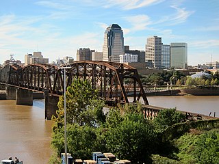
North Louisiana, also known locally as Sportsman's Paradise, is a region in the U.S. state of Louisiana. The region has two metropolitan areas: Shreveport-Bossier City and Monroe-West Monroe; the Shreveport area is the largest metropolitan area by population in North Louisiana.

<span class="mw-page-title-main">Monroe–Ruston Combined Statistical Area</span> Combined Statistical Area in Louisiana, United States

The Monroe–Ruston Combined Statistical Area is made up of five parishes in northern Louisiana. The statistical area consists of the Monroe Metropolitan Statistical Area and the Ruston Micropolitan Statistical Area. As of the 2010 census, the CSA had a population of 251,155.

References

  1. "Census - Geography Profile: Lincoln Parish, Louisiana" . Retrieved January 21, 2023.
  2. "" + theTitle + "". Archived from the original on March 29, 2015. Retrieved January 22, 2015.
  3. "A bill has passed both Houses..." The Ouachita Telegraph. February 15, 1873. p. 3. Retrieved May 12, 2024.
  4. "AN ACT Creating the parish of Lincoln, aud providing for the organization thereof". Bossier Banner-Progress. August 9, 1873. p. 1. Retrieved May 12, 2024.
  5. "The people of Lincoln parish..." The Donaldsonville Chief. October 25, 1884. p. 1. Retrieved May 12, 2024.
  6. "The people of Lincoln parish..." The Donaldsonville Chief. November 15, 1884. p. 1. Retrieved May 12, 2024.
  7. "Find a County". National Association of Counties. Retrieved June 7, 2011.
  8. Robert W. Preucel, Stephen A. Mrozowski, Contemporary Archaeology in Theory: The New Pragmatism, John Wiley and Sons, 2010, p. 177
  9. Gannett, Henry (1905). The Origin of Certain Place Names in the United States. U.S. Government Printing Office. p.  187.
  10. "Lincoln Parish election returns, November 6, 2012". staticresults.sos.la.gov. Retrieved November 17, 2012.
  11. "2010 Census Gazetteer Files". United States Census Bureau. August 22, 2012. Archived from the original on September 28, 2013. Retrieved September 1, 2014.
  12. "U.S. Decennial Census". United States Census Bureau. Retrieved September 1, 2014.
  13. "Historical Census Browser". University of Virginia Library. Retrieved September 1, 2014.
  14. "Population of Counties by Decennial Census: 1900 to 1990". United States Census Bureau. Retrieved September 1, 2014.
  15. "Census 2000 PHC-T-4. Ranking Tables for Counties: 1990 and 2000" (PDF). United States Census Bureau. Archived (PDF) from the original on March 27, 2010. Retrieved September 1, 2014.
  16. "State & County QuickFacts". United States Census Bureau. Archived from the original on June 6, 2011. Retrieved August 10, 2013.
  17. "Explore Census Data". data.census.gov. Retrieved December 29, 2021.
  18. Leip, David. "Dave Leip's Atlas of U.S. Presidential Elections". uselectionatlas.org. Retrieved March 7, 2018.

32°36′N92°40′W / 32.60°N 92.66°W / 32.60; -92.66