West Feliciana Parish, Louisiana

Last updated

West Feliciana Parish
Rosedown Plantation-268.JPG
Map of Louisiana highlighting West Feliciana Parish.svg
Location within the U.S. state of Louisiana
Louisiana in United States.svg
Louisiana's location within the U.S.
Coordinates: 30°52′N91°25′W / 30.87°N 91.42°W / 30.87; -91.42
CountryFlag of the United States.svg United States
StateFlag of Louisiana.svg  Louisiana
Founded1824
Named for Marie Félicité de Gálvez
Seat St. Francisville
Largest townSt. Francisville
Area
  Total426 sq mi (1,100 km2)
  Land403 sq mi (1,040 km2)
  Water23 sq mi (60 km2)  5.3%
Population
 (2020)
  Total15,310
  Density36/sq mi (14/km2)
Time zone UTC−6 (Central)
  Summer (DST) UTC−5 (CDT)
Congressional district 5th
Website wfparish.org
Louisiana State Penitentiary entrance AngolaLAPrison.jpg
Louisiana State Penitentiary entrance

West Feliciana Parish (French: Paroisse de Feliciana Ouest; Spanish: Parroquia de Feliciana Occidental) is a civil parish located in the U.S. state of Louisiana. At the 2020 census, the population was 15,310. [1] The parish seat is St. Francisville. [2] The parish was established in 1824. [3]

Contents

In 1824 Feliciana Parish was divided into East Feliciana Parish and West Feliciana Parish, in recognition of the increases in population throughout the parish. West Feliciana Parish is part of the Baton Rouge metropolitan statistical area.

The River Bend Nuclear Generating Station, operated by Entergy Nuclear, is located in West Feliciana Parish below St. Francisville. It produces approximately 10 percent of the total electric power demand in Louisiana. [4] The Louisiana State Penitentiary is also located in the parish, in Angola. It occupies 18,000 acres at a site in a river bend, surrounded on three sides by water.

History

Bayou Sara seen from the Mississippi, late 1840s; St. Francisville on the rise in the background. Bayou Sacra Luisiana Henry Lewis.jpg
Bayou Sara seen from the Mississippi, late 1840s; St. Francisville on the rise in the background.

18th and 19th centuries

Following the founding of the Bayou Sara settlement by French Franciscan/Capuchin monks in the late 17th century, the area was explored further by France, Spain, and Great Britain. The original settlement was flooded repeatedly and finally lost to the waters of the Mississippi River. [5]

After 1763, when France was defeated by Britain in the Seven Years' War, it ceded its territories of La Louisiane east of the Mississippi River to Great Britain, which included it in its West Florida province. Spain gained control of the area in about 1780 – during the American Revolutionary War – and maintained its authority in the area for the next three decades.

In 1810, the colonists, many of whom were of British descent, rebelled against the Spanish colonial regime and established the short-lived independent Republic of West Florida. Within a few months, the United States declared the area to be part of the territory included in the Louisiana Purchase of 1803. (Today this region is called the Florida Parishes).

Feliciana Parish was established in 1810, in the Territory of Orleans, which was admitted to the Union two years later as the state of Louisiana. With continued growth of population, in 1824 Feliciana Parish was divided into the East Feliciana and West Feliciana parishes. [3]

During the American Civil War, West Feliciana Parish provided financial assistance to the families of soldiers fighting for the Confederate States of America. Wives and children of soldiers were to receive from $10 to $40 per month, depending on family size. [6]

West Feliciana and national politics

Since before the Civil War, white conservative voters in West Feliciana historically supported the Democratic Party. After Louisiana effectively disenfranchised most black voters under provisions of its 1898 constitution, the state joined others in the South as being a one-party state. The white-dominated legislature passed increasingly stringent Jim Crow and segregation legislation.

But after passage of Federal civil rights legislation in the mid-1960s, including protection of constitutional voting rights, many white conservatives in the South began to shift to the Republican Party, at least in terms of supporting Presidential candidates. In 1972, the year of Richard Nixon's re-election as President, after widespread anti-war protests and other cultural changes, West Feliciana was the only Louisiana parish to support the Democratic ticket of George McGovern and Sargent Shriver. During the same period, most African Americans in the South began to support the national Democratic Party, which had helped their drive for civil rights.

Since 2000, voters in the parish have supported the Republican Party candidates in Presidential elections. That year Bush-Cheney polled 2,512 votes (55 percent), compared to 2,187 (45 percent) for Democrats Al Gore and Joe Lieberman. West Feliciana voters helped to re-elect George W. Bush and Dick Cheney in 2004, with 2,932 (56 percent) to 2,214 (42 percent) over Democratic candidates John Kerry and John Edwards. Republicans John McCain and Sarah Palin won the parish in 2008, but they lost the Presidential/Vice-Presidential contest to Democrats Barack Obama and Joe Biden.

Geography

According to the U.S. Census Bureau, the parish has a total area of 426 square miles (1,100 km2), of which 403 square miles (1,040 km2) is land and 23 square miles (60 km2) (5.3%) is water. [7]

The parish is located on the Mississippi River, and is bordered by Pointe Coupee Parish to the west and East Feliciana Parish to the east. The parish is about 30 miles (48 km) north of Baton Rouge and about 60 miles (97 km) south of Natchez, Mississippi. [8]

The area—including references to the loess soil and Louisiana State Penitentiary—was used by author Walker Percy as the setting for his last novel, The Thanatos Syndrome .

Major highways

Adjacent parishes and counties

National protected area

Communities

Town

Unincorporated communities

Demographics

Historical population
CensusPop.Note
1820 12,732
1830 8,629−32.2%
1840 10,91026.4%
1850 13,24521.4%
1860 11,671−11.9%
1870 10,499−10.0%
1880 12,80922.0%
1890 15,06217.6%
1900 15,9946.2%
1910 13,449−15.9%
1920 12,303−8.5%
1930 10,924−11.2%
1940 11,7207.3%
1950 10,169−13.2%
1960 12,39521.9%
1970 11,376−8.2%
1980 12,1867.1%
1990 12,9156.0%
2000 15,11117.0%
2010 15,6253.4%
2020 15,310−2.0%
U.S. Decennial Census [9]
1790–1960 [10] 1900–1990 [11]
1990–2000 [12] 2010 [13]
West Feliciana Parish racial composition as of 2020 [14]
RaceNumberPercentage
White (non-Hispanic)10,58569.14%
Black or African American (non-Hispanic)3,58923.44%
Native American 950.62%
Asian 300.2%
Pacific Islander 50.03%
Other/Mixed 3552.32%
Hispanic or Latino 6514.25%

As of the 2020 United States census, there were 15,310 people, 3,869 households, and 2,497 families residing in the parish. The 2019 American Community Survey estimated 15,428 people lived in the parish, down from 15,625 at the 2010 United States census, and up from 15,111 at the 2000 U.S. census. Among the population, the median age was 41.4. In 2000, the parish the population was spread out, with 20.30% under the age of 18, 8.70% from 18 to 24, 40.00% from 25 to 44, 23.80% from 45 to 64, and 7.20% who were 65 years of age or older. The median age was 37 years. For every 100 females, there were 191.10 males. For every 100 females age 18 and over, there were 223.60 males.

The racial and ethnic makeup was 53.5% non-Hispanic white, 44.5% Black and African American, 0.2% American Indian and Alaska Native, 0.6% Asian alone, 0.1% some other race, 1.1% two or more races, and 1.2% Hispanic and Latin American of any race. [15] In 2000, the racial makeup of the parish was 50.51% Black or African American, 48.63% White, 0.20% Native American, 0.17% Asian, 0.02% Pacific Islander, 0.03% from other races, and 0.44% from two or more races; 1.04% of the population were Hispanic or Latin American of any race. [16]

In 2019, there were 3,869 households and 5,446 housing units. The parish had a home-ownership rate of 73.2%, and the median housing value was $229,500. Median gross rent was $785, and the median household income was $59,637. Approximately 23.6% of the population lived at or below the poverty line. At the 2000 census, the median income for a household in the parish was $39,667, and the median income for a family was $47,239. Males had a median income of $35,046 versus $21,922 for females. The per capita income for the parish was $16,201. About 15.00% of families and 19.90% of the population were below the poverty line, including 25.30% of those under age 18 and 23.40% of those age 65 or over.

In January 2007, the state of Louisiana estimated that 15,318 people lived in the parish, with 5,000 of them being prisoners at Louisiana State Penitentiary (Angola). [8]

Government and infrastructure

Louisiana State Penitentiary of the Louisiana Department of Public Safety and Corrections is located in unincorporated West Feliciana Parish. [17]

United States presidential election results for West Feliciana Parish, Louisiana [18]
Year Republican Democratic Third party
No.%No.%No.%
2020 3,86361.63%2,29836.66%1071.71%
2016 3,39058.46%2,24838.77%1612.78%
2012 3,25756.38%2,44142.25%791.37%
2008 3,15056.05%2,41542.97%550.98%
2004 2,93256.19%2,21442.43%721.38%
2000 2,51251.69%2,18745.00%1613.31%
1996 1,61635.86%2,41653.62%47410.52%
1992 1,50134.32%2,32853.22%54512.46%
1988 1,85445.34%2,14652.48%892.18%
1984 2,09747.38%2,29651.88%330.75%
1980 1,23733.23%2,34162.90%1443.87%
1976 99033.83%1,89064.59%461.57%
1972 1,00142.13%1,07945.41%29612.46%
1968 29611.08%1,30348.76%1,07340.16%
1964 89780.09%22319.91%00.00%
1960 19622.00%27130.42%42447.59%
1956 44256.38%29637.76%465.87%
1952 50364.32%27935.68%00.00%
1948 10217.53%10117.35%37965.12%
1944 17829.47%42670.53%00.00%
1940 12716.71%63383.29%00.00%
1936 7611.88%56488.13%00.00%
1932 498.09%55791.91%00.00%
1928 9017.61%42182.39%00.00%
1924 154.14%34795.86%00.00%
1920 348.72%35691.28%00.00%
1916 82.92%26195.26%51.82%
1912 30.96%28189.49%309.55%

Education

The entrance to the West Feliciana Parish Public Schools schools complex in Bains WestFelicianaschoolsentrance.JPG
The entrance to the West Feliciana Parish Public Schools schools complex in Bains

West Feliciana Parish Public Schools serves the parish. [19] All residents are zoned to Bains Lower Elementary School, Bains Elementary School, West Feliciana Middle School, and West Feliciana High School. [20] Tunica Elementary School, a parish elementary school, was closed after the parish school board voted to close the school in May 2011. [21]

Some students in the parish attend Wilkinson County Christian Academy in Wilkinson County, Mississippi. [22]

The West Feliciana Parish Library is located in St. Francisville. [23] The library, previously a part of the Audubon Regional Library System, became independent in January 2004. [24]

The parish's proximity to Baton Rouge offers access to Louisiana State University, Southern University, and Baton Rouge Community College. [8] It is in the service area of Baton Rouge Community College. [25]

News media

Founded in 1892, the St. Francisville Democrat was the parish's local newspaper and served as the official journal for the parish's governmental bodies. The paper, founded by W. W. Leake and his wife May, was originally called "The True Democrat." After Leake's death, May Leake married Elrie Robinson and they continued publication of the newspaper. [26] After May's death in the 1920s, Robinson remarried. The paper was later published by Elrie's son James M. Robinson, who sold it to Marilyn and David Goff in the 1970s. The newspaper was bought by Louisiana Suburban Press in 1979. Louisiana Suburban Press is part of Louisiana State Newspapers, owned by B.I. Moody.

On October 1, 2014, the Democrat was sold by Louisiana State Newspapers to Capital City Press Inc., owner of The Advocate (a major newspaper of Baton Rouge) and of other newspapers in the region.

The Feliciana Explorer is an independent publication mailed to residents of East and West Feliciana. It is owned and published by Daniel Duggan, who also owns the Zachary Post.

Founded in 1976, The Angolite is a news magazine created and published at the Louisiana State Penitentiary. [27] Each year, it publishes six issues. [28]

Notable people

See also

Related Research Articles

<span class="mw-page-title-main">Wilkinson County, Mississippi</span> County in Mississippi, United States

Wilkinson County is a county located in the southwest corner of the U.S. state of Mississippi. As of 2020, its population was 8,587. Its county seat is Woodville. Bordered by the Mississippi River on the west, the county is named for James Wilkinson, a Revolutionary War military leader and first governor of the Louisiana Territory after its acquisition by the United States in 1803.

<span class="mw-page-title-main">West Baton Rouge Parish, Louisiana</span> Parish in Louisiana, United States

West Baton Rouge Parish is one of the sixty-four parishes in the U.S. state of Louisiana. Established in 1807, its parish seat is Port Allen. With a 2020 census population of 27,199 residents, West Baton Rouge Parish is part of the Baton Rouge metropolitan statistical area.

<span class="mw-page-title-main">St. Helena Parish, Louisiana</span> Parish in Louisiana, United States

St. Helena Parish is a parish in the U.S. state of Louisiana. At the 2020 United States census, the population was 10,920. Its seat is Greensburg. The parish was created in 1810. St. Helena Parish is part of the Baton Rouge metropolitan area.

<span class="mw-page-title-main">Pointe Coupee Parish, Louisiana</span> Parish in Louisiana, United States

Pointe Coupee Parish is a parish located in the U.S. state of Louisiana. As of the 2020 census, the population was 20,758. The parish seat is New Roads.

<span class="mw-page-title-main">East Feliciana Parish, Louisiana</span> Parish in Louisiana, United States

East Feliciana Parish is a parish located in the U.S. state of Louisiana. At the 2020 census, the population was 19,531. The parish seat is Clinton.

<span class="mw-page-title-main">East Baton Rouge Parish, Louisiana</span> Parish in Louisiana, United States

East Baton Rouge Parish is the most populous parish in the U.S. state of Louisiana. Its population was 456,781 at the 2020 census. The parish seat is Baton Rouge, Louisiana's state capital. East Baton Rouge Parish is located within the Greater Baton Rouge area.

<span class="mw-page-title-main">Concordia Parish, Louisiana</span> Parish in Louisiana, United States

Concordia Parish borders the Mississippi River in eastern central Louisiana. As of the 2020 census, the population was 18,687. The parish seat is Vidalia. The parish was formed in 1807.

<span class="mw-page-title-main">Ascension Parish, Louisiana</span> Parish in Louisiana, United States

Ascension Parish is a parish located in the U.S. state of Louisiana. As of the 2020 census, the population was 126,500. Its parish seat is Donaldsonville. The parish was created in 1807. Ascension Parish is part of the Baton Rouge metropolitan statistical area.

<span class="mw-page-title-main">Jackson, Louisiana</span> Town in Louisiana, United States

Jackson is a town in East Feliciana Parish, Louisiana, United States. The population was 3,842 at the 2010 U.S. census, down from 4,130 in 2000; the 2020 population estimates program determined Jackson had a population of 3,707. It is part of the Baton Rouge metropolitan statistical area.

<span class="mw-page-title-main">St. Francisville, Louisiana</span> Town in Louisiana, United States

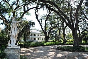
St. Francisville is a town in and the parish seat of, West Feliciana Parish, Louisiana, United States. The population was 1,765 at the 2010 U.S. census, and 1,589 at the 2020 population estimates program. It is part of the Baton Rouge metropolitan statistical area.

<span class="mw-page-title-main">Woodville, Mississippi</span> Town in Mississippi, United States

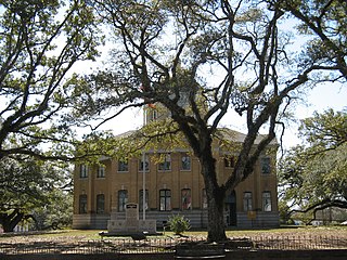
Woodville is one of the oldest towns in Mississippi and is the county seat of Wilkinson County, Mississippi, United States. Its population as of 2020 was 928.

<span class="mw-page-title-main">Florida Parishes</span> Region in Louisiana, United States

The Florida Parishes, on the east side of the Mississippi River—an area also known as the Northshore or Northlake region—are eight parishes in the southeastern portion of the U.S. state of Louisiana.

<span class="mw-page-title-main">River Bend Nuclear Generating Station</span> Nuclear power plant in Louisiana, United States

River Bend Nuclear Generating Station is a nuclear power station on a 3,300-acre (1,300 ha) site near St. Francisville, Louisiana in West Feliciana Parish, approximately 30 miles (50 km) north of Baton Rouge. The station has one sixth generation General Electric boiling water reactor that has a nominal gross electric output of about 1010 MWe. Commercial operation began on June 16, 1986. In 2003, owners applied and were approved for a power upgrade of approximately 52 megawatts in 2003. The nameplate capacity is 974 MW.

<span class="mw-page-title-main">Republic of West Florida</span> Short-lived 1810 republic in North America

The Republic of West Florida, officially the State of Florida, was a short-lived republic in the western region of Spanish West Florida for just over 2+12 months during 1810. It was annexed and occupied by the United States later in 1810; it subsequently became part of Eastern Louisiana.

<span class="mw-page-title-main">Baton Rouge metropolitan area</span> Metropolitan area in Louisiana, United States

The Baton Rouge metropolitan statistical area, as defined by the United States Office of Management and Budget, or simply the Baton Rouge metropolitan area or Greater Baton Rouge, is a sprawling metropolitan statistical area surrounding the city of Baton Rouge. Its principal city Baton Rouge is unusual because it has no major incorporated satellite cities, a rarity for a metropolitan area of its size. Including the western edge of the Florida Parishes regions, it is known as "Plantation Country", the "Capital Region", and "The 225". At the 2010 U.S. census, the metropolitan area had a population of 802,484, up from 705,973 in 2000. At the 2020 census, its population increased to 870,569, up from 2020 estimates at 858,571.

<span class="mw-page-title-main">John James Audubon Bridge (Mississippi River)</span> Bridge in West Feliciana Parish, Louisiana

The John James Audubon Bridge, completed and opened in May 2011, is a Lower Mississippi River crossing between Pointe Coupee and West Feliciana parishes in south central Louisiana. The bridge has the second longest cable-stayed span in the Western Hemisphere at 1,583 ft (482 m), after Mexico's Baluarte Bridge with a 1,706 ft (520 m) span, and has a total length of 12,883 ft (3,927 m)—nearly three-and-a-half times longer than the Baluarte Bridge's 3,688 ft (1,124 m) total length. The Audubon Bridge replaces the ferry between the communities of New Roads and St. Francisville. The bridge also serves as the only bridge structure on the Mississippi River between Natchez, Mississippi and Baton Rouge, Louisiana. The bridge conveys Louisiana Highway 10, which is in a concurrence there with the Zachary Taylor Parkway.

<span class="mw-page-title-main">Louisiana Highway 10</span>

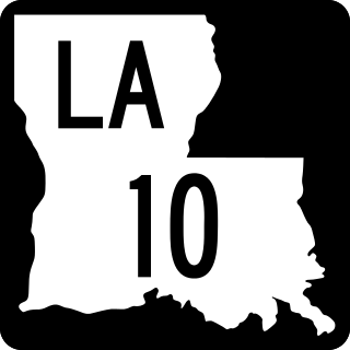
Louisiana Highway 10 (LA 10) is a state highway located in southern Louisiana. It runs 255.51 miles (411.20 km) in an east–west direction from U.S. Highway 171 (US 171) south of Leesville to the Mississippi state line east of Bogalusa.

<span class="mw-page-title-main">Feliciana Parish, Louisiana</span> Former parish of Louisiana (1810–1824)

<span class="mw-page-title-main">Louisiana Highway 66</span>

Louisiana Highway 66 (LA 66) is a state highway located in southeastern Louisiana. It runs 19.62 miles (31.58 km) in a general east–west direction from the main entrance of the Louisiana State Penitentiary at Angola to a junction with U.S. Highway 61 (US 61) north of St. Francisville.

<span class="mw-page-title-main">Tunica, Louisiana</span> Unincorporated community in Louisiana, United States

Tunica is an unincorporated community in West Feliciana Parish, Louisiana, United States. Its elevation is 66 feet.

References

  1. "QuickFacts: West Feliciana Parish, Louisiana". U.S. Census Bureau.
  2. "Find a County". National Association of Counties. Retrieved June 7, 2011.
  3. 1 2 "West Feliciana Parish". Center for Cultural and Eco-Tourism. Retrieved September 5, 2014.
  4. "Entergy Nuclear – River Bend Station". www.entergy-nuclear.com. Archived from the original on August 31, 2009. Retrieved March 7, 2018.
  5. "The Lost River Town, History and Archaeology of Bayou Sara" (PDF). Louisiana Office of the Lieutenant Governor. FEMA/Coastal Environments, Inc. Archived (PDF) from the original on June 24, 2021. Retrieved August 3, 2021.
  6. John D. Winters, The Civil War in Louisiana, Baton Rouge: Louisiana State University Press, 1963, ISBN   0-8071-0834-0, p. 74
  7. "2010 Census Gazetteer Files". United States Census Bureau. August 22, 2012. Archived from the original on September 28, 2013. Retrieved September 2, 2014.
  8. 1 2 3 "West Feliciana Parish School System Profile." (Archive) West Feliciana Parish School System. 1. Retrieved on February 18, 2012.
  9. "U.S. Decennial Census". United States Census Bureau. Retrieved September 2, 2014.
  10. "Historical Census Browser". University of Virginia Library. Retrieved September 2, 2014.
  11. "Population of Counties by Decennial Census: 1900 to 1990". United States Census Bureau. Retrieved September 2, 2014.
  12. "Census 2000 PHC-T-4. Ranking Tables for Counties: 1990 and 2000" (PDF). United States Census Bureau. Archived (PDF) from the original on March 27, 2010. Retrieved September 2, 2014.
  13. "State & County QuickFacts". United States Census Bureau. Archived from the original on August 27, 2011. Retrieved August 18, 2013.
  14. "Explore Census Data". data.census.gov. Retrieved December 28, 2021.
  15. "Geography Profile: West Feliciana Parish, Louisiana". data.census.gov. Retrieved August 4, 2021.
  16. "U.S. Census website". United States Census Bureau . Retrieved January 31, 2008.
  17. "Louisiana State Penitentiary Archived 2010-09-24 at the Wayback Machine ." Louisiana Department of Public Safety and Corrections. Retrieved on August 24, 2010.
  18. Leip, David. "Dave Leip's Atlas of U.S. Presidential Elections". uselectionatlas.org. Retrieved March 7, 2018.
  19. "2020 CENSUS - SCHOOL DISTRICT REFERENCE MAP: West Feliciana Parish, LA" (PDF). U.S. Census Bureau. Archived (PDF) from the original on July 31, 2022. Retrieved July 31, 2022. - Text list
  20. "Schools Archived February 3, 2012, at the Wayback Machine ." West Feliciana Parish Public Schools. Retrieved on February 18, 2012.
  21. Rivas, Brittany. "West Feliciana board closes elementary school Archived June 30, 2014, at the Wayback Machine ." WBRZ . May 18, 2007. Retrieved on February 18, 2012.
  22. "About the School" (Archive). Wilkinson County Christian Academy. Retrieved on April 15, 2015.
  23. "Directory." West Feliciana Parish Library. Retrieved on September 29, 2010.
  24. "About Us." West Feliciana Parish Library. Retrieved on September 29, 2010.
  25. "Our Colleges". Louisiana's Technical and Community Colleges . Retrieved June 3, 2021.
  26. Butler, Anne (September 23, 2014). "Farewell to St. Francisville's True Democrat and Welcome to The Advocate". Friends in St. Francisville, La. Retrieved December 1, 2014.
  27. "Rehabilitative Services / Work Programs Archived 2011-02-14 at the Wayback Machine ." Louisiana State Penitentiary. Retrieved on August 29, 2010.
  28. ""Time in Prison" Archived October 23, 2012, at WebCite , Louisiana Department of Public Safety & Corrections. 34/40. Retrieved on September 23, 2010.
  29. 'Illinois Blue Book 1927–1928. Biographical Sketch of Sheadrick Bond Turner, pg. 212–213

30°52′N91°25′W / 30.87°N 91.42°W / 30.87; -91.42