Vernon Parish, Louisiana

Last updated

Vernon Parish, Louisiana
Parish of Vernon
Vernon Parish courthouse from SE 1.jpg
Vernon Parish courthouse in Leesville
Map of Louisiana highlighting Vernon Parish.svg
Location within the U.S. state of Louisiana
Louisiana in United States.svg
Louisiana's location within the U.S.
CountryFlag of the United States.svg  United States
StateFlag of Louisiana.svg  Louisiana
Region Central Louisiana
FoundedMarch 30, 1871(152 years ago) (1871-03-30)
Named for Mount Vernon
Parish seat Leesville
Largest municipality Simpson (area)
Leesville (population)
Incorporated municipalities
6 (total)
  • 1 city, 3 towns, and 2 villages
  • (located entirely or partially
    within parish boundaries)
Area
  Total3,470 km2 (1,341 sq mi)
  Land3,440 km2 (1,328 sq mi)
  Water40 km2 (14 sq mi)
  percentage3 km2 (1.0 sq mi)
Population
 (2020)
  Total48,750
  Density14/km2 (36/sq mi)
Time zone UTC-6 (CST)
  Summer (DST) UTC-5 (CDT)
Area code 337
Congressional district 4th
Website Vernon Parish Police Jury

Vernon Parish (French: Paroisse de Vernon) is a parish located in the U.S. state of Louisiana. As of the 2020 census, the population was 48,750. [1] The parish seat is Leesville. [2] Bordered on the west by the Sabine River, the parish was founded in 1871 during the Reconstruction era. [3]

Contents

It was long a center of the timber industry, which harvested pine in the hills and bottomland hardwoods. Construction of a railway to the area in 1897 stimulated the marketing of lumber and businesses in the area.

Since World War II, Fort Johnson, formerly Fort Polk, has been most important to the parish economy. The population of the Leesville area rapidly increased fivefold after the fort was opened. Vernon Parish is part of the Fort Johnson South, LA Micropolitan Statistical Area, which is also included in the DeRidder-Fort Johnson South, LA Combined Statistical Area.[ citation needed ]

History

The area comprising Vernon was a part of a tract of land whose control was disputed in the late 18th century between the United States and Spain. They called this land the "Neutral Strip" and refrained from posting police or military personnel there. As a result, the area became a haven for outlaws. Prior to the United States acquisition of this territory through the Louisiana Purchase from France in 1803, the primary settlers who came to the area were ethnic French and Spanish.

During this period, Dr. Timothy Burr, a Massachusetts native who had migrated to Louisiana from Mt. Vernon, Ohio, established the community of Burr Ferry at his landing on the Sabine River. This community became known as the "Gateway to Louisiana" from the west. For decades this area was part of the Natchitoches, Rapides, and Sabine parishes, which were established soon after the US acquired this territory in the early nineteenth century. The timber industry was most important to the local economy, with both pines of the hills and bottomland hardwoods being harvested. Some landowners had their land cleared by slaves to establish plantations for cotton cultivation.

During the American Civil War, an artillery site was constructed nearby. Now called the "Confederate Breast Works", it was manned by the Confederacy to guard against Union movements along the Nolan Trace. [4] [5]

On March 30. 1871, the Louisiana General Assembly passed an act to create Vernon Parish, by taking territory from the three parishes noted above, as population had increased in the area. There are four versions of how the parish was named; the only official State version is that it was named in honor of Mt. Vernon, the home of George Washington. [6]

Leesville was designated as the parish seat of Vernon from the start. It was incorporated February 15, 1900. The city was founded by Dr. Edmund E. Smart, who donated land from his plantation for the development of the parish seat. It was named by Senator John Rowell Smart, his father, in honor of General Robert E. Lee. The Big House from the Smart plantation still stands, where the city has grown up around it. It is located at what today is the corner of Lula and First streets. [5]

Folklore accounts of the naming of the parish are: 1) that it was named after a race horse owned by Joe Moore, one of the members of the committee chosen to name the parish, who claimed that by naming the parish after his fast horse the committee would insure the growth of the parish: 2) that it was named after a popular teacher who had been an officer in the Royal Navy, only mentioned as "Mr. Vernon". The decision was made to avoid disputes among the parish founders, each of whom wanted to name it after himself. 3) The final account tells that the committee had been arguing over the name while drinking in a store. Trying to preserve his precious whiskey and profits, the host suggested the committee stop a local man passing by on a mule-drawn cart and name the parish whatever the man said was the mule's name. The man responded, "I calls him Vernon, 'cause he's the fastes' mule in de country." [7]

Vernon Parish map, 1895. 1895 Vernon Parish.jpg
Vernon Parish map, 1895.
Old First National Bank Building in downtown Leesville, LA, now the Courthouse Annex building. VernonParishCHAnnex-01.jpg
Old First National Bank Building in downtown Leesville, LA, now the Courthouse Annex building.

In the late 1890s the timber industry, which was the dominant industry in the parish from its creation, began to boom with the construction of the Kansas City Southern Railway in 1897. It increased access to markets. The railway continues to operate in the early 21st century. [5]

20th century to present

In the period after World War I, Vernon Parish became the site of two socialist-based communities. The Llano del Rio Cooperative Colony [9] developed as New Llano, established in 1917. The second was the Christian Commonwealth Colony. These colonies attempted to attract economists and sociologists to conduct an experiment in communal membership and the sharing of labor duties. Llano del Rio was the larger community, with more than 10,000 people, and was also the longest-surviving. Both colonies failed in the 1930s during the economic stress of the Great Depression. [5]

In 1941, the United States Army opened Camp Polk, shortly after the outbreak of war in Europe, with the German invasion of Poland and other actions. Camp Polk quickly surpassed the timber industry as the dominant force in the parish's economy. After the camp opened, the population of the parish seat of Leesville rapidly climbed from 3,500 to 18,000. Named after Leonidas Polk, the first Episcopal Bishop in Louisiana and known as the "Fighting Bishop of the Confederacy", it served as one of the major Army training camps during World War II.

In the 21st century, Fort Johnson is the 5th-largest military installation in the nation. The facility covers approximately 200,000 acres (810 km2). It has stimulated the development of associated businesses in the area and related populations. With the regular reassignment of soldiers, accompanied by dependents, to and from the fort, Vernon Parish has a more varied culture than might be expected from its location. Its residents come from all over the country. [5]

Geography

According to the U.S. Census Bureau, the parish has a total area of 1,341 square miles (3,470 km2), of which 1,328 square miles (3,440 km2) is land and 14 square miles (36 km2) (1.0%) is water. [10] It is the largest parish in Louisiana by land area.

Major highways

Adjacent parishes and counties

National protected area

Demographics

Historical population
CensusPop.Note
1880 5,160
1890 5,90314.4%
1900 10,32774.9%
1910 17,38468.3%
1920 20,49317.9%
1930 20,047−2.2%
1940 19,142−4.5%
1950 18,974−0.9%
1960 18,301−3.5%
1970 53,794193.9%
1980 53,475−0.6%
1990 61,96115.9%
2000 52,531−15.2%
2010 52,334−0.4%
2020 48,750−6.8%
U.S. Decennial Census [11]
1790–1960 [12] 1900–1990 [13]
1990–2000 [14] 2010 [15]
Vernon Parish racial composition as of 2020 [16]
RaceNumberPercentage
White (non-Hispanic)33,59968.92%
Black or African American (non-Hispanic)6,32512.97%
Native American 4840.99%
Asian 8621.77%
Pacific Islander 2890.59%
Other/Mixed 3,0166.19%
Hispanic or Latino 4,1758.56%

As of the 2020 United States census, there were 48,750 people, 17,696 households, and 12,375 families residing in the parish.

Education

The Vernon Parish Library in Leesville File-Vernon Parish Library 004.JPG
The Vernon Parish Library in Leesville

Primary and secondary education

All public schools in Vernon Parish are operated by the Vernon Parish School Board, which operates 18 public schools and one optional school. [17] Schools providing a secondary education include:

Colleges and universities

The Louisiana Technical College (LTC) system operates the Lamar Salter campus south of New Llano. The Central Louisiana Technical College Lamar Salter campus is one of 40 LTC campuses across the state. [19]

Northwestern State University (NSU), is a four-year public university primarily situated in Natchitoches, Louisiana and is part of the University of Louisiana System. The NSU-Leesville/Fort Johnson Campus is located on Highway 467 near Fort Johnson. It serves the civilian communities of Vernon, Beauregard, and Sabine parishes, as well as the military community at Fort Johnson. http://leesville.nsula.edu/

The Fort Johnson Education Center offers self-development opportunities for Service members, military family members, Department of the Defense employees, military Retirees, Department of Defense contractors, and civilians from the local community in the classroom, distance learning, and online environments. Civilian students coming to the post for classes are required to use the main entrance located off U.S. Highway 171. [20]

Central Michigan University (CMU) operates a campus at Fort Johnson. [21]

Central Texas College (CTC) is a public, open-admission community college offering associate degrees and certificate programs in academic, professional and vocational/technical fields. Due to its proximity to Fort Johnson, CTC has evolved from a small junior college into a college catering to the military. CTC also help students transition from a 2-year to a 4-year degree through numerous articulation agreements with 4-year institutions nationwide. [22]

Louisiana State University offers a Master of Arts in Liberal Arts. [23]

The Upper Iowa University (UIU) at Fort Johnson offers classes on post to both military personnel and civilians in the area. It was opened in 1995 and offers bachelor's degrees in nine majors. Courses can also be blended with UIU distance learning programs (online and independent study) to complete 11 other majors. Certificate programs are also available. UIU offers courses on post during five eight-week terms during the academic year. All courses are offered during the evenings and on weekends. [24]

Public libraries

The Vernon Parish Library operates public libraries. It operates the main library and the Dunbar Branch Library in Leesville and the Pitkin Branch Library in Pitkin. [25]

National Guard

The Louisiana Army National Guard maintains a maintenance facility which services its vehicles on Fort Johnson. 3-156 IB part of 256th Tiger Brigade is located at Fort Johnson.

Communities

Map of Vernon Parish, Louisiana With Municipal Labels Map of Vernon Parish Louisiana With Municipal Labels.PNG
Map of Vernon Parish, Louisiana With Municipal Labels

Cities

Towns

Villages

Unincorporated areas

Census-designated places

Other communities

Notable people

This is the Vernon Parish Police Jury's Gov't Complex located in the old First Liberty Federal Savings building. VPPJ Govt Complex 001.JPG
This is the Vernon Parish Police Jury's Gov't Complex located in the old First Liberty Federal Savings building.

Politics

United States presidential election results for Vernon Parish, Louisiana [29]
Year Republican Democratic Third party
No.%No.%No.%
2020 14,10781.69%2,89816.78%2631.52%
2016 13,47180.99%2,66516.02%4972.99%
2012 12,15077.83%3,17320.33%2871.84%
2008 11,94675.76%3,53422.41%2891.83%
2004 11,03272.44%4,03526.50%1621.06%
2000 8,79463.60%4,65533.67%3782.73%
1996 5,44939.02%6,19544.36%2,32216.63%
1992 5,91240.04%6,00540.66%2,85019.30%
1988 7,45358.40%4,99839.17%3102.43%
1984 9,03567.58%4,07630.49%2581.93%
1980 5,86943.68%7,19853.57%3692.75%
1976 3,97037.94%6,20259.26%2932.80%
1972 6,22577.62%1,34516.77%4505.61%
1968 1,57418.29%1,49617.38%5,53664.33%
1964 3,69650.91%3,56449.09%00.00%
1960 1,99132.32%3,14551.06%1,02416.62%
1956 2,37249.81%2,15845.32%2324.87%
1952 2,13035.73%3,83264.27%00.00%
1948 2966.46%1,93942.32%2,34751.22%
1944 1,02224.95%3,07575.05%00.00%
1940 3118.29%3,43991.71%00.00%
1936 92824.65%2,83175.21%50.13%
1932 461.55%2,86896.60%551.85%
1928 50018.58%2,19181.42%00.00%
1924 1429.18%1,37288.69%332.13%
1920 20515.21%1,14384.79%00.00%
1916 443.45%75459.09%47837.46%

See also

Notes

  1. Fort Johnson North is actually a military community contained within Fort Johnson Army Installation.
  2. Fort Johnson South is actually a military community contained within Fort Johnson Army Installation.

Related Research Articles

<span class="mw-page-title-main">Vermilion Parish, Louisiana</span> Parish in Louisiana, United States

Vermilion Parish is a parish located in the U.S. state of Louisiana, created in 1844. The parish seat is Abbeville. Vermilion Parish is part of the Lafayette metropolitan statistical area, and located in southern Acadiana. At the 2020 U.S. census, the population was 57,359.

<span class="mw-page-title-main">St. Landry Parish, Louisiana</span> Parish in Louisiana, United States

St. Landry Parish is a parish located in the U.S. state of Louisiana. As of the 2020 Census, the population was 82,540. The parish seat is Opelousas. The parish was established in 1807.

<span class="mw-page-title-main">Sabine Parish, Louisiana</span> Parish in the United States

Sabine Parish is a parish located in the U.S. state of Louisiana. As of the 2020 census, the population was 22,155. The parish seat and largest town is Many.

<span class="mw-page-title-main">Jefferson Davis Parish, Louisiana</span> Parish in Louisiana, United States

Jefferson Davis Parish is a parish located in the U.S. state of Louisiana. As of the 2020 census, the population was 32,250. The parish seat is Jennings. Jefferson Davis Parish is named after the president of the Confederacy during the American Civil War, Jefferson Davis. It is located in southwestern Louisiana and forms a part of the Acadiana region.

<span class="mw-page-title-main">Evangeline Parish, Louisiana</span> Parish in Louisiana, United States

Evangeline Parish is a parish located in the U.S. state of Louisiana. As of the 2020 census, the population was 32,350. The parish seat is Ville Platte.

<span class="mw-page-title-main">Beauregard Parish, Louisiana</span> Parish in Louisiana, United States

Beauregard Parish is a parish located in the U.S. state of Louisiana. As of the 2020 census, the population was 36,549. The parish seat is DeRidder. The parish was formed on January 1, 1913.

<span class="mw-page-title-main">Acadia Parish, Louisiana</span> Parish in Louisiana, United States

Acadia Parish is a parish located in the U.S. state of Louisiana. At the 2020 U.S. census, the population was 57,576. The parish seat is Crowley. The parish was founded from parts of St. Landry Parish in 1886, and later an election was held to determine the parish seat, ending when Crowley beat Rayne and Prairie Hayes. Acadia Parish is included in the Lafayette metropolitan statistical area.

<span class="mw-page-title-main">Many, Louisiana</span> Town in Louisiana, United States

Many is a town in, and the parish seat of Sabine Parish in western Louisiana, United States. The population was 2,853 at the 2010 census, a decrease of 36 or 1.246 percent from 2000.

<span class="mw-page-title-main">Hornbeck, Louisiana</span> Town in Louisiana, United States

Hornbeck is a town in Vernon Parish, Louisiana, United States. The population was 480 at the 2010 census, up from 435 in 2000. It is part of the Fort Johnson South Micropolitan Statistical Area.

<span class="mw-page-title-main">Leesville, Louisiana</span> City in Louisiana, United States

Leesville is a city in, and the parish seat of, Vernon Parish, Louisiana, United States. The population was 5,649 at the 2020 census. It is part of the Fort Johnson South micropolitan area and is additionally served by the Leesville Airport. The city is home to the Fort Johnson U.S. Army installation.

<span class="mw-page-title-main">New Llano, Louisiana</span> Town in Louisiana, United States

New Llano is a town in Vernon Parish, Louisiana, United States. The population was 2,504 at the 2010 census. It is a part of the Fort Johnson South Micropolitan Statistical Area.

<span class="mw-page-title-main">DeRidder, Louisiana</span> City in Louisiana, United States

DeRidder is a city in, and the parish seat of, Beauregard Parish, Louisiana, United States. A small portion of the city extends into Vernon Parish. As of the 2010 census DeRidder had a population of 10,578. It is the smaller principal city of the DeRidder-Fort Johnson South CSA, a Combined Statistical Area that includes the Fort Johnson South and DeRidder micropolitan areas, which had a combined population of 87,988 at the 2010 census.

<span class="mw-page-title-main">U.S. Route 171</span> United States Numbered Highway in Louisiana

U.S. Highway 171 (US 171) is a part of the United States Numbered Highway System and the only route within that system currently located entirely within the state of Louisiana. It spans 177.44 miles (285.56 km) in a north–south direction from the junction of US 90 and Louisiana Highway 14 (LA 14) in Lake Charles to the junction of US 79/US 80 and LA 3094 in Shreveport.

<span class="mw-page-title-main">Central Louisiana</span> Region in Louisiana, United States

Central Louisiana (Cenla), also known as the Crossroads, is a region of the U.S. state of Louisiana.

Vernon Parish School Board is a school district headquartered in Leesville, Louisiana, United States.

<span class="mw-page-title-main">DeRidder-Fort Johnson South, LA CSA</span> Combined Statistical Area in Louisiana, United States

The DeRidder-Fort Johnson South, LA combined statistical area is made up of two parishes in central Louisiana. The statistical area consists of the Fort Johnson South Micropolitan Statistical Area and the DeRidder Micropolitan Statistical Area. As of the 2000 census, the CSA had a population of 85,517.

<span class="mw-page-title-main">Hornbeck High School</span> Public school in the United States

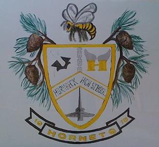
Hornbeck High School is a school located in Hornbeck, Louisiana, United States. The PK-12 school is a part of the Vernon Parish School District headquartered in Leesville and has been home to Hornbeck High School, the only public school in the community, since 1898. In 1910, Hornbeck High School became an affiliated high school, although the school's crest bears the date 1913.

<span class="mw-page-title-main">Pitkin, Louisiana</span> CDP in Louisiana, United States

Pitkin is a census-designated place (CDP) in Vernon Parish, Louisiana, United States.

Fort Johnson-Vernon Wildlife Management Area is a 105,545-acre tract (42,713 ha) of protected area in Louisiana within the United States Army military reservation of Fort Johnson. The WMA is located approximately ten miles southeast of Leesville, in Vernon Parish, east of U.S. Highway 171, one mile south of Louisiana Highway 28 and one mile north of Louisiana Highway 10.

William H. West was an American educator and politician.

References

  1. "Census - Geography Profile: Vernon Parish, Louisiana". United States Census Bureau . Retrieved January 22, 2023.
  2. "Find a County". National Association of Counties. Archived from the original on May 31, 2011. Retrieved June 7, 2011.
  3. "Vernon Parish". Center for Cultural and Eco-Tourism. Retrieved September 5, 2014.
  4. The Nolan Trace
  5. 1 2 3 4 5 Information in the History section may be found on the Greater Vernon Parish Chamber of Commerce Website Archived September 28, 2007, at the Wayback Machine .
  6. The State of Louisiana maintains an official website for each of the State's 64 parishes at Louisiana.gov.
  7. All four found in: Wise, Erbon. Tall Pines II: A History of Vernon Parish, Louisiana and its People. LCCN   87-51644. OCLC   18715154.
  8. The map may be found at this website; it was researched and posted by Pam Rietsch.
  9. Not to be confused with the Llano del Rio established in Antelope Valley, California in 1915 and abandoned in 1917.
  10. "2010 Census Gazetteer Files". United States Census Bureau. August 22, 2012. Archived from the original on September 28, 2013. Retrieved September 2, 2014.
  11. "U.S. Decennial Census". United States Census Bureau. Retrieved September 2, 2014.
  12. "Historical Census Browser". University of Virginia Library. Retrieved September 2, 2014.
  13. "Population of Counties by Decennial Census: 1900 to 1990". United States Census Bureau. Retrieved September 2, 2014.
  14. "Census 2000 PHC-T-4. Ranking Tables for Counties: 1990 and 2000" (PDF). United States Census Bureau. Archived (PDF) from the original on March 27, 2010. Retrieved September 2, 2014.
  15. "State & County QuickFacts". United States Census Bureau. Retrieved August 18, 2013.
  16. "Explore Census Data". data.census.gov. Retrieved December 29, 2021.
  17. "Vernon Parish School District – School List". Archived from the original on April 21, 2012. Retrieved July 22, 2012.
  18. "Vernon Parish Optional School History".
  19. "Central Louisiana Technical College-Lamar Salter-Campus". Archived from the original on January 7, 2011.
  20. "Fort Polk Education Center". Archived from the original on June 29, 2012.
  21. "Central Michigan University at Fort Polk, Louisiana".
  22. "Central Texas College – Fort Polk Site". Archived from the original on April 25, 2012.
  23. "Louisiana State University – Special Programs". Archived from the original on December 11, 2011. Retrieved July 22, 2012.
  24. "The Upper Iowa Center at Fort Polk, LA". Archived from the original on August 19, 2012.
  25. "Sexual Predator Policy." ( Archived September 3, 2014, at the Wayback Machine ) Vernon Parish Library. Retrieved March 23, 2013.
  26. "Membership in the Louisiana House of Representatives, 1812–2016: Vernon Parish" (PDF). house.louisiana.gov. Archived from the original (PDF) on October 6, 2014. Retrieved October 22, 2014.
  27. "Rep. Frank A. Howard". house.louisiana.gov. Retrieved July 19, 2011.
  28. "Obituary of Bryan A. Poston, Sr". Shreveport Times, October 4, 2009. Retrieved October 4, 2009.
  29. Leip, David. "Dave Leip's Atlas of U.S. Presidential Elections". uselectionatlas.org. Retrieved March 9, 2018.

31°07′N93°11′W / 31.11°N 93.19°W / 31.11; -93.19