
Kaplan is a city in Vermilion Parish, Louisiana, United States. The population was 4,600 at the 2010 census, and 4,345 at the 2020 population estimates program. It is part of the Abbeville micropolitan statistical area in Acadiana.
Tullos is a town in LaSalle and Winn parishes in the U.S. state of Louisiana, along Castor Creek. The population was 385 at the 2010 census.

Plantsville is a neighborhood in the town of Southington, Hartford County, Connecticut. It is centered at the merger between South Main Street and West Main Street. As of the 2000 Census there were 10,387 people living in the Zip Code Tabulation Area for zip code 06479, which is assigned the postal city name Plantsville. The Zip Code Tabulation Area includes the entire southwestern corner of the town of Southington, including Marion and Milldale. Beginning in 2015 Plantsville was listed as a census-designated place.

This page documents notable tornadoes and tornado outbreaks worldwide in 2004. Strong and destructive tornadoes form most frequently in the United States, Bangladesh, and Eastern India, but they can occur almost anywhere under the right conditions. Tornadoes also develop occasionally in southern Canada during the Northern Hemisphere's summer and somewhat regularly at other times of the year across Europe, Asia, and Australia. Tornadic events are often accompanied with other forms of severe weather, including strong thunderstorms, strong winds, and hail.

This page documents notable tornadoes and tornado outbreaks worldwide in 2003. Strong and destructive tornadoes form most frequently in the United States, Bangladesh, and Eastern India, but they can occur almost anywhere under the right conditions. Tornadoes also develop occasionally in southern Canada during the Northern Hemisphere's summer and somewhat regularly at other times of the year across Europe, Asia, and Australia. Tornadic events are often accompanied with other forms of severe weather, including strong thunderstorms, strong winds, and hail.

The 1953 Vicksburg, Mississippi tornado was a deadly F5 tornado that struck Vicksburg, Mississippi on Saturday, December 5, 1953. A total of 38 people were killed, 270 others were injured, and damages were estimated at $25 million in damage. It remains the fifth-deadliest tornado to affect the U.S. state of Mississippi, behind the 1840 Great Natchez Tornado, the 1936 tornado in Tupelo, the 1971 tornado in Cary, and the 1966 tornado in Jackson. It is one of just four F5 tornadoes recorded in Mississippi since 1950.

Franklin is an unincorporated community in Crawford County, Kansas, United States. As of the 2020 census, the population of the community and nearby areas was 473. Franklin is located along U.S. Route 69, 1 mile (1.6 km) south of Arma, or 5.9 miles (9.5 km) north of Frontenac.

This page documents the tornadoes and tornado outbreaks of 1992, primarily in the United States. Most tornadoes form in the U.S., although some events may take place internationally. Tornado statistics for older years like this often appear significantly lower than modern years due to fewer reports or confirmed tornadoes, however by the 1990s tornado statistics were coming closer to the numbers we see today.
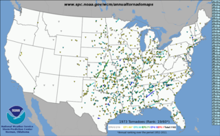
This page documents notable tornadoes and tornado outbreaks worldwide in 1973, but mostly features events in the United States. According to tornado researcher Thomas P. Grazulis, documentation of tornadoes outside the United States was historically less exhaustive, owing to the lack of monitors in many nations and, in some cases, to internal political controls on public information. Most countries only recorded tornadoes that produced severe damage or loss of life. Consequently, available documentation in 1973 mainly covered the United States. On average, most recorded tornadoes, including the vast majority of significant—F2 or stronger—tornadoes, form in the U.S., although as many as 500 may take place internationally. Some locations, like Bangladesh, are as prone to violent tornadoes as the U.S., meaning F4 or greater events on the Fujita scale.

This page documents the tornadoes and tornado outbreaks of 1971, primarily in the United States. Most tornadoes form in the U.S., although some events may take place internationally. Tornado statistics for older years like this often appear significantly lower than modern years due to fewer reports or confirmed tornadoes.
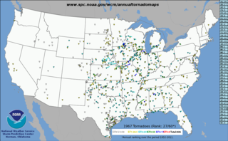
This page documents the tornadoes and tornado outbreaks of 1967, primarily in the United States. Most tornadoes form in the U.S., although some events may take place internationally. Tornado statistics for older years like this often appear significantly lower than modern years due to fewer reports or confirmed tornadoes.
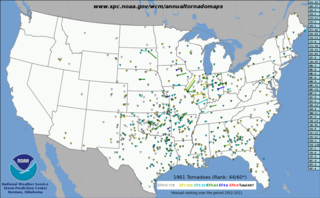
This page documents the tornadoes and tornado outbreaks of 1961, primarily in the United States. Most tornadoes form in the U.S., although some events may take place internationally. Tornado statistics for older years like this often appear significantly lower than modern years due to fewer reports or confirmed tornadoes.

This page documents the tornadoes and tornado outbreaks of 1962, primarily in the United States. Most tornadoes form in the U.S., although tornadoes events can take place internationally. Tornado statistics for older years like this often appear significantly lower than modern years due to fewer reports or confirmed tornadoes.

This page documents the tornadoes and tornado outbreaks of 1954, primarily in the United States. Most tornadoes form in the U.S., although some events may take place internationally. Tornado statistics for older years like this often appear significantly lower than modern years due to fewer reports or confirmed tornadoes.

This page documents the tornadoes and tornado outbreaks of 1953, primarily in the United States. Most tornadoes form in the U.S., although some events may take place internationally. Tornado statistics for older years like this often appear significantly lower than modern years due to fewer reports or confirmed tornadoes. This was the first year to record an F5 tornado as well as one of the deadliest tornado seasons in official U.S. records, which go back to 1950.
This page documents the tornadoes and tornado outbreaks of 1950, primarily in the United States. Most tornadoes form in the U.S., although some events may take place internationally.
A widespread, destructive, and deadly tornado outbreak sequence affected the Southeastern United States from April 28 to May 2, 1953, producing 24 tornadoes, including five violent F4 tornadoes. The deadliest event of the sequence was an F4 tornado family that ravaged Robins Air Force Base in Warner Robins, Georgia, on April 30, killing at least 18 people and injuring 300 or more others. On May 1, a pair of F4 tornadoes also struck Alabama, causing a combined nine deaths and 15 injuries. Additionally, another violent tornado struck rural Tennessee after midnight on May 2, killing four people and injuring eight. Additionally, two intense tornadoes impacted Greater San Antonio, Texas, on April 28, killing three people and injuring 20 altogether. In all, 36 people were killed, 361 others were injured, and total damages reached $26.713 million (1953 USD). There were additional casualties from non-tornadic events as well, including a washout which caused a train derailment that injured 10.
The first six days of December 1953 produced a destructive and deadly tornado outbreak sequence across the Southern United States. There were 19 confirmed tornadoes, including a violent F4 tornado that hit the northwest side of Alexandria, Louisiana and even more violent F5 tornado that hit Vicksburg, Mississippi. In all, the tornadoes killed 49 people, injured 404 others, and caused $45,709 million in damage. This was the last in a series of deadly and catastrophic outbreaks to strike the US in 1953.


