St. John the Baptist Parish is a parish located in the U.S. state of Louisiana. As of the 2010 census, the population was 45,924. The parish seat is Edgard, an unincorporated area, and the largest city is LaPlace, which is also unincorporated.

Sabine Parish is a parish located in the U.S. state of Louisiana. As of the 2010 census, the population was 24,233. The seat of the parish is Many.

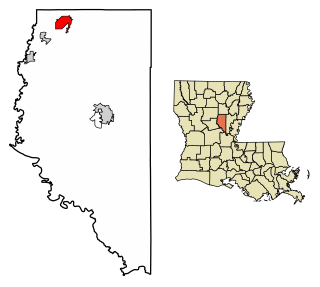
Ouachita Parish is located in the northern part of the U.S. state of Louisiana. As of the 2010 census, the population was 153,720. The parish seat is Monroe. The parish was formed in 1807.

Caldwell Parish is a parish located in the U.S. state of Louisiana. As of the 2010 census, the population was 10,132, making it the fifth-least populous parish in Louisiana. The parish seat is Columbia. Most residents live in the country even beyond the three rural communities in the parish.
Olla is a town in northwest La Salle Parish, Louisiana, United States, located in the heart of the Louisiana Central Hill Country.

Natchitoches is a small city and the parish seat of Natchitoches Parish, Louisiana, United States. Established in 1714 by Louis Juchereau de St. Denis as part of French Louisiana, the community was named after the indigenous Natchitoches people.

Belle Vernon is a borough in Fayette County, Pennsylvania, United States. It is situated along the Monongahela River abutting two other counties, Westmoreland to the north and Washington across the river. As of the 2010 census Belle Vernon had a population of 1,093.

The Calcasieu River is a river on the Gulf Coast in southwestern Louisiana. Approximately 200 miles (320 km) long, it drains a largely rural area of forests and bayou country, meandering southward to the Gulf of Mexico. The name "Calcasieu" comes from the Indian Atakapa language katkosh, for "eagle", and yok, "to cry".

Established in 1994, the Cane River Creole National Historical Park serves to preserve the resources and cultural landscapes of the Cane River region in Natchitoches Parish, Louisiana. Located along the Cane River Lake, the park is approximately 63 acres and includes two French Creole cotton plantations, Oakland and Magnolia. Both plantations are complete in their historic settings, including landscapes, outbuildings, structures, furnishings, and artifacts; and they are the most intact French Creole cotton plantations in the United States. In total, 65 historic structures and over a million artifacts enhance the National Park Service mission as it strives to tell the story of the evolution of plantation agriculture through the perspective of the land owners, enslaved workers, overseers, skilled workers, and tenant farmers who resided along the Cane River for over two hundred years. This park is included as a site on the Louisiana African American Heritage Trail.

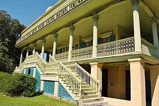
Uptown is a section of New Orleans, Louisiana, United States, on the east bank of the Mississippi River, encompassing a number of neighborhoods between the French Quarter and the Jefferson Parish line. It remains an area of mixed residential and small commercial properties, with a wealth of 19th-century architecture. It includes part or all of Uptown New Orleans Historic District, which is listed on the National Register of Historic Places.
Castor Creek or Bayou Castor is a 103-mile-long (166 km) tributary of the Little River in north-central Louisiana in the United States. Via the Little, Ouachita and Red rivers, it is part of the watershed of the Mississippi River.

Sugartown is an unincorporated community and census-designated place in Beauregard Parish, Louisiana, United States, approximately 16 miles (26 km) east of DeRidder. As of the 2010 census it had a population of 54. The geographical center of Sugartown today is posted as the intersection of LA 112 and LA 113. The original community was much larger.

Mount Vernon is an unincorporated community in the town of Springdale, Dane County, Wisconsin, United States.

Claiborne Avenue is a major thoroughfare in New Orleans, Louisiana. It runs the length of the city, about 9.5 miles (15.3 km), beginning at the Jefferson Parish line and ending at the St. Bernard Parish line; the street continues in each of these locations under different names. It is called South Claiborne Avenue upriver from Canal Street and North Claiborne Avenue from Canal to St. Bernard Parish.
Roy is an unincorporated community located approximately two miles south of Castor in Bienville Parish in northern Louisiana, United States. To the south of Roy is Ashland in Natchitoches Parish. Named for Roy Otis Martin, Sr. (1890-1973), the community was the location of a closed sawmill owned and operated by the Martin Timber Company based in Alexandria, Louisiana, and operated by Martin's son, Roy O. Martin, Jr., and then his grandson, Roy O. Martin, III.
Fullerton is an unincorporated community in Vernon Parish, Louisiana, United States. Fullerton was once an industrial community, having developed around a large lumber mill. In 1986, the community and mill were added to the National Register of Historic Places as Fullerton Mill and Town because of their role in industry and in the development of housing for the mill workers.
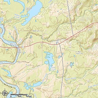
Burr Ferry is an unincorporated community at the junction of LA 8 and LA 111 south, in Vernon Parish, Louisiana, United States. The community is two miles from the site of the old Burr's Ferry on the Sabine River, at the Texas line. The Sabine River, at this location, is the site of two listings on the National Register of Historic Places; Burr's Ferry Bridge, and Burr's Ferry Earthworks.
Alco is an unincorporated community in Vernon Parish, Louisiana, United States.

Girard is an unincorporated community in Richland Parish, Louisiana, United States.


