Fort Johnson South, Louisiana

Last updated

Fort Johnson South
Hamlet of Fort Johnson South
Vernon Parish Louisiana incorporated and unincorporated areas Fort Johnson South highlighted.svg
Location in Vernon Parish and the state of Louisiana.
Coordinates: 31°02′49″N93°12′40″W / 31.04694°N 93.21111°W / 31.04694; -93.21111
CountryFlag of the United States.svg  United States
StateFlag of Louisiana.svg  Louisiana
Parish Vernon
Area
[1]
  Total6.16 sq mi (15.96 km2)
  Land6.16 sq mi (15.95 km2)
  Water0.01 sq mi (0.01 km2)
Population
 (2020)
  Total7,950
  Density1,291.00/sq mi (498.43/km2)
Time zone UTC-6 (CST)
  Summer (DST) UTC-5 (CDT)
ZIP code
71459
Area code 337
FIPS code 22-26757

Fort Johnson South is a census-designated place (CDP) in Vernon Parish, Louisiana, United States. The population was 11,000 at the 2000 census.

Contents

Fort Johnson South is the larger principal city of the Fort Johnson South-DeRidder CSA, a Combined Statistical Area that includes the Fort Johnson South (Vernon Parish) and DeRidder (Beauregard Parish) micropolitan areas, [2] [3] which had a combined population of 85,517 at the 2000 census. [4]

Geography

Fort Johnson South is located at 31°2′49″N93°12′40″W / 31.04694°N 93.21111°W / 31.04694; -93.21111 (31.047003, -93.211213). [5]

According to the United States Census Bureau, the CDP has a total area of 6.2 square miles (16 km2), all land.[ citation needed ]

Demographics

Historical population
CensusPop.Note
2020 7,950
U.S. Decennial Census [6]

As of the census [4] of 2000, there were 11,000 people, 2,383 households, and 2,175 families residing in the CDP. The population density was 1,785.9 inhabitants per square mile (689.5/km2). There were 2,864 housing units at an average density of 465.0 per square mile (179.5/km2). The racial makeup of the CDP was 58.8% White, 27.7% African American, 0.9% Native American, 2.2% Asian, 0.5% Pacific Islander, 5.3% from other races, and 4.6% from two or more races. Hispanic or Latino of any race were 11.7% of the population.

There were 2,383 households, out of which 72.8% had children under the age of 18 living with them, 82.8% were married couples living together, 6.0% had a female householder with no husband present, and 8.7% were non-families. 8.3% of all households were made up of individuals, and none had someone living alone who was 65 years of age or older. The average household size was 3.45 and the average family size was 3.63.

In the CDP, the population was spread out, with 33.0% under the age of 18, 29.3% from 18 to 24, 35.9% from 25 to 44, 1.7% from 45 to 64, and 0.1% who were 65 years of age or older. The median age was 22 years. For every 100 females, there were 152.4 males. For every 100 females age 18 and over, there were 181.3 males.

The median income for a household in the CDP was $32,993, and the median income for a family was $33,463. Males had a median income of $20,855 versus $17,776 for females. The per capita income for the CDP was $12,176. About 8.7% of families and 10.8% of the population were below the poverty line, including 14.1% of those under age 18 and none of those age 65 or over.

Notable people

Related Research Articles

<span class="mw-page-title-main">Reader, Arkansas</span> Census-designated place in Arkansas, United States

Reader is an unincorporated census-designated place in Nevada and Ouachita counties in the U.S. state of Arkansas. As of the 2010 census, its population is 66. Per the 2020 census, the population was 40.

<span class="mw-page-title-main">River Park, Florida</span> Census-designated place in Florida, United States

River Park is a census-designated place (CDP) in St. Lucie County, Florida, United States. The population was 5,222 at the 2010 census, at which time it was listed as Port St. Lucie-River Park. It is part of the Port St. Lucie Metropolitan Statistical Area.

<span class="mw-page-title-main">North DeLand, Florida</span> CDP in Florida, United States

North DeLand is a census-designated place (CDP) in Volusia County, Florida, United States. The population was 1,510 at the 2020 census.

<span class="mw-page-title-main">Fort Hall, Idaho</span> Census-designated place in Idaho, United States

Fort Hall is a census-designated place (CDP) in the southeastern part of the U.S. state of Idaho which is split between Bannock County in the south and Bingham County in the north. It is located on the Fort Hall Indian Reservation along the Snake River north of Pocatello and near the site of the original Fort Hall in the Oregon Country. The population was 3,201 at the 2010 census.

Lydia is an unincorporated community and census-designated place (CDP) in Iberia Parish, Louisiana, United States. The population was 952 at the 2010 census, down from 1,079 at the 2000 census. It is part of the New Iberia Micropolitan Statistical Area.

Amelia is a census-designated place (CDP) in St. Mary Parish, Louisiana, United States. The population was 2,459 at the 2010 census. It is part of the Morgan City Micropolitan Statistical Area.

Bayou Vista is a census-designated place (CDP) in St. Mary Parish, Louisiana, United States. The population was 4,652 at the 2010 census. It is part of the Morgan City Micropolitan Statistical Area.

<span class="mw-page-title-main">Natalbany, Louisiana</span> CDP in Louisiana, United States

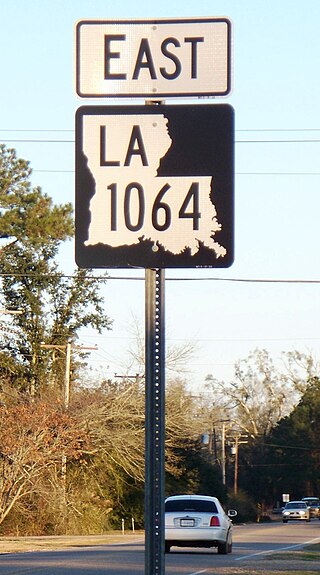
Natalbany is a census-designated place (CDP) in Tangipahoa Parish, Louisiana, United States. The population was 1,739 at the 2000 census. It is part of the Hammond Micropolitan Statistical Area.

<span class="mw-page-title-main">Anacoco, Louisiana</span> Village in Louisiana, United States

Anacoco is a village in Vernon Parish, Louisiana, United States. The population was 869 at the 2010 census. It is part of the Fort Polk South Micropolitan Statistical Area.

<span class="mw-page-title-main">Fort Johnson North, Louisiana</span> Census-designated place in Louisiana, United States

Fort Johnson North is a census-designated place (CDP) in Vernon Parish, Louisiana, United States. The population was 3,279 at the 2000 census. It is part of the Fort Johnson South Micropolitan Statistical Area.

<span class="mw-page-title-main">Simpson, Louisiana</span> Village in Louisiana, United States

Simpson is a village in Vernon Parish, Louisiana, United States. The population was 638 at the 2010 census. It is part of the Fort Polk South Micropolitan Statistical Area.

<span class="mw-page-title-main">Helena Valley Southeast, Montana</span> Census-designated place in Montana, United States

Helena Valley Southeast is a census-designated place (CDP) in Lewis and Clark County, Montana, United States. The population was 8,227 at the 2010 census. It is part of the Helena Micropolitan Statistical Area.

<span class="mw-page-title-main">South Rosemary, North Carolina</span> Census-designated place in North Carolina, United States

South Rosemary is an unincorporated area and census-designated place (CDP) in Halifax County, North Carolina, United States. The population was 2,836 at the 2010 census. It is part of the Roanoke Rapids, North Carolina Micropolitan Statistical Area.

<span class="mw-page-title-main">Mission, Oregon</span> Unincorporated community in the state of Oregon, United States

Mission is an unincorporated community in Umatilla County, Oregon, United States. For statistical purposes, the United States Census Bureau has defined Mission as a census-designated place (CDP). The population was 1,019 at the 2000 census.

<span class="mw-page-title-main">Loomis, South Dakota</span> CDP in South Dakota, United States

Loomis is a census-designated place (CDP) in Davison County, South Dakota, United States. The population was 33 at the 2020 census. It is part of the Mitchell, South Dakota Micropolitan Statistical Area.

<span class="mw-page-title-main">Tselakai Dezza, Utah</span> CDP in Utah, United States

Tselakai Dezza is a census-designated place (CDP) in San Juan County, Utah, United States. The population was 103 at the 2000 census.

<span class="mw-page-title-main">Lyndhurst, Virginia</span> CDP in Virginia, United States

Lyndhurst is a census-designated place (CDP) in Augusta County, Virginia, United States. The population was 1,490 at the 2010 census. It is part of the Staunton–Waynesboro Micropolitan Statistical Area.

<span class="mw-page-title-main">Sherando, Virginia</span> CDP in Virginia, United States

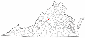
Sherando is a census-designated place (CDP) in Augusta County, Virginia, United States. The population was 688 at the 2010 census. It is part of the Staunton–Waynesboro Micropolitan Statistical Area.

<span class="mw-page-title-main">MacArthur, West Virginia</span> Census-designated place in West Virginia, United States

MacArthur is a census-designated place (CDP) in Raleigh County, West Virginia, United States. Originally, it was named Hollywood and renamed MacArthur after General of the Army Douglas MacArthur in 1942. The population was 1,500 at the 2010 census.

<span class="mw-page-title-main">Lake Wisconsin, Wisconsin</span> CDP in Wisconsin, United States

Lake Wisconsin is a census-designated place (CDP) in Columbia and Sauk counties, in the towns of Lodi and Merrimac, in Wisconsin, United States. The population was 4,189 at the 2010 census.

References

  1. "2020 U.S. Gazetteer Files". United States Census Bureau. Retrieved March 20, 2022.
  2. MICROPOLITAN STATISTICAL AREAS AND COMPONENTS Archived June 29, 2007, at the Wayback Machine , Office of Management and Budget, 2007-05-11. Accessed 2008-08-01.
  3. COMBINED STATISTICAL AREAS AND COMPONENT CORE BASED STATISTICAL AREAS Archived June 29, 2007, at the Wayback Machine , Office of Management and Budget, 2007-05-11. Accessed 2008-08-01.
  4. 1 2 "U.S. Census website". United States Census Bureau . Retrieved January 31, 2008.
  5. "US Gazetteer files: 2010, 2000, and 1990". United States Census Bureau. February 12, 2011. Retrieved April 23, 2011.
  6. "Census of Population and Housing". Census.gov. Retrieved June 4, 2016.