Fort Johnson North, Louisiana

Last updated

Fort Johnson North
Vernon Parish Louisiana incorporated and unincorporated areas Fort Johnson North highlighted.svg
Location in Vernon Parish and the state of Louisiana.
Coordinates: 31°06′13″N93°10′07″W / 31.10361°N 93.16861°W / 31.10361; -93.16861
CountryUnited States
StateLouisiana
Parish Vernon
Area
[1]
  Total8.38 sq mi (21.72 km2)
  Land8.38 sq mi (21.70 km2)
  Water0.00 sq mi (0.01 km2)
Elevation
354 ft (108 m)
Population
 (2020)
  Total2,179
  Density260.02/sq mi (100.40/km2)
Time zone UTC-6 (CST)
  Summer (DST) UTC-5 (CDT)
Area code 337
FIPS code 22-26746

Fort Johnson North is a census-designated place (CDP) in Vernon Parish, Louisiana, United States. The population was 3,279 at the 2000 census. It is part of the Fort Johnson South Micropolitan Statistical Area.

Contents

Geography

Fort Johnson North is located at 31°6′13″N93°10′7″W / 31.10361°N 93.16861°W / 31.10361; -93.16861 (31.103611, -93.168617). [2]

According to the United States Census Bureau, the CDP has a total area of 8.1 square miles (21 km2), all land.

Demographics

Historical population
CensusPop.Note
2020 2,179
U.S. Decennial Census [3]

As of the census [4] of 2000, there were 3,279 people, 1,076 households, and 1,039 families residing in the CDP. The population density was 403.7 inhabitants per square mile (155.9/km2). There were 1,126 housing units at an average density of 138.6 per square mile (53.5/km2). The racial makeup of the CDP was 62.9% White, 21.3% African American, 1.3% Native American, 2.1% Asian, 0.6% Pacific Islander, 5.1% from other races, and 6.7% from two or more races. Hispanic or Latino of any race were 11.9% of the population.

There were 1,076 households, out of which 67.8% had children under the age of 18 living with them, 91.5% were married couples living together, 4.0% had a female householder with no husband present, and 3.4% were non-families. 3.2% of all households were made up of individuals, and none had someone living alone who was 65 years of age or older. The average household size was 3.05 and the average family size was 3.10.

In the CDP, the population was spread out, with 36.2% under the age of 18, 20.8% from 18 to 24, 42.2% from 25 to 44, 0.7% from 45 to 64, and 0.1% who were 65 years of age or older. The median age was 23 years. For every 100 females, there were 101.3 males. For every 100 females age 18 and over, there were 99.2 males.

The median income for a household in the CDP was $31,921, and the median income for a family was $32,037. Males had a median income of $25,729 versus $19,044 for females. The per capita income for the CDP was $11,425. About 8.7% of families and 10.2% of the population were below the poverty line, including 11.7% of those under age 18 and none of those age 65 or over.

Related Research Articles

<span class="mw-page-title-main">Mesquite Creek, Arizona</span> CDP in Mohave County, Arizona

Mesquite Creek is an unincorporated community and census-designated place (CDP) in Mohave County, Arizona, United States. The population was 403 at the 2020 census.

<span class="mw-page-title-main">Brookridge, Florida</span> Census-designated place in Florida, United States

Brookridge is a census-designated place (CDP) in Hernando County, Florida, United States. The population was 4,420 at the 2010 census, up from 3,279 at the 2000 census.

<span class="mw-page-title-main">Buckingham, Florida</span> Census-designated place in Florida, United States

Buckingham is an unincorporated community and census-designated place (CDP) in Lee County, Florida, United States. The population was 4,443 at the 2020 census, up from 4,036 at the 2010 census. It is part of the Cape Coral-Fort Myers, Florida Metropolitan Statistical Area.

<span class="mw-page-title-main">North Fort Myers, Florida</span> Census-designated place in Florida, United States

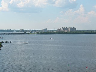
North Fort Myers is an unincorporated area and census-designated place (CDP) in Lee County, Florida, United States. It is part of the Cape Coral-Fort Myers, Florida Metropolitan Statistical Area. The population was 42,719 at the 2020 census.

<span class="mw-page-title-main">San Carlos Park, Florida</span> Census-designated place in Florida, United States

San Carlos Park is a census-designated place (CDP) in Lee County, Florida, United States. The population was 18,563 at the 2020 census. It is part of the Cape Coral-Fort Myers, Florida Metropolitan Statistical Area.

<span class="mw-page-title-main">Paradise Heights, Florida</span> Census-designated place in Florida, United States

Paradise Heights is a census-designated place and an unincorporated area in Orange County, Florida, United States. The population was 1,215 at the 2010 census. It is part of the Orlando–Kissimmee Metropolitan Statistical Area.

<span class="mw-page-title-main">Crystal Springs, Florida</span> CDP in Florida, United States

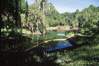
Crystal Springs is a hydrological spring and a census-designated place (CDP) in Pasco County, Florida, United States. The population was 1,175 at the 2000 census.

<span class="mw-page-title-main">Hansell, Iowa</span> City in Iowa, United States

Hansell is a city in Franklin County, Iowa, United States. The population was 82 at the time of the 2020 census.

<span class="mw-page-title-main">Fort Johnson South, Louisiana</span> Census-designated place in Louisiana, United States

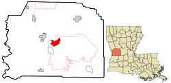
Fort Johnson South is a census-designated place (CDP) in Vernon Parish, Louisiana, United States. The population was 11,000 at the 2000 census.

<span class="mw-page-title-main">Forestdale, Massachusetts</span> Census-designated place in Massachusetts, United States

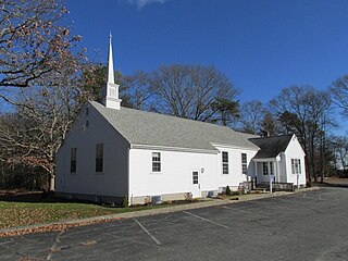
Forestdale is a village and census-designated place (CDP) within the town of Sandwich in Barnstable County, Massachusetts, United States. The population of Forestdale was 4,099 at the 2010 census. It is the most populous of the three CDPs in Sandwich. The ZIP code of Forestdale is 02644.

<span class="mw-page-title-main">Cedar Grove, New Mexico</span> CDP in New Mexico, United States

Cedar Grove is a census-designated place (CDP) in Santa Fe County, New Mexico, United States. It is part of the Santa Fe, New Mexico Metropolitan Statistical Area. The population was 747 at the 2010 census. Cedar Grove was formerly a stage and freight stop. It has developed into a Santa Fe suburb. New Mexico "cedars" are abundant in the town.

Fort McKinley is an unincorporated community and census designated place in Harrison Township in Montgomery County, Ohio, United States. It was delineated as a census-designated place (CDP) at the 2000 census, when its population was 3,989. It was not delineated as a CDP for the 2010 census.

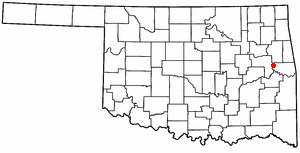
Carlisle is a census-designated place (CDP) in Sequoyah County, Oklahoma, United States. It is part of the Fort Smith, Arkansas-Oklahoma Metropolitan Statistical Area. The population was 606 at the 2010 census.

Evening Shade is a census-designated place (CDP) in Sequoyah County, Oklahoma, United States. It is part of the Fort Smith, Arkansas-Oklahoma Metropolitan Statistical Area. The population was 359 at the 2010 census.

<span class="mw-page-title-main">Notchietown, Oklahoma</span> CDP in Oklahoma, United States

Notchietown is a census-designated place (CDP) in Sequoyah County, Oklahoma, United States. It is part of the Fort Smith, Arkansas-Oklahoma Metropolitan Statistical Area. The population was 430 at the 2000 census.

Stony Point is a census-designated place (CDP) in Sequoyah County, Oklahoma, United States. It is part of the Fort Smith, Arkansas-Oklahoma Metropolitan Statistical Area. The population was 177 at the 2000 census.

<span class="mw-page-title-main">Scenic Oaks, Texas</span> Census-designated place in Texas, United States

Scenic Oaks is a census-designated place (CDP) in Bexar County, Texas, United States. It is part of the San Antonio Metropolitan Statistical Area. The population was 10,458 at the 2010 census, up from 4,957 at the 2010 census.

<span class="mw-page-title-main">Northwest Snohomish, Washington</span> Former CDP in Washington, United States

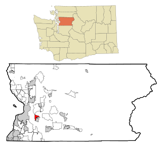
Northwest Snohomish is a former census-designated place (CDP) in Snohomish County, Washington, United States. The population was 2,061 at the 2000 census. The CDP ceased to exist at the 2010 census, with some parts having been annexed by Snohomish and other parts going to the new Fobes Hill CDP.

<span class="mw-page-title-main">Hatfield (CDP), Massachusetts</span> Census-designated place in Massachusetts, United States

Hatfield is a census-designated place (CDP) comprising the main village in the town of Hatfield in Hampshire County, Massachusetts, United States. The population of the CDP was 1,318 at the 2010 census, out of a total town population of 3,279. It is part of the Springfield, Massachusetts Metropolitan Statistical Area.

Olive Branch is an unincorporated census-designated place in Alexander County, Illinois, United States. It has a post office with the ZIP code 62969. Its population was 650 at the 2020 census.

References

  1. "2020 U.S. Gazetteer Files". United States Census Bureau. Retrieved March 20, 2022.
  2. "US Gazetteer files: 2010, 2000, and 1990". United States Census Bureau. February 12, 2011. Retrieved April 23, 2011.
  3. "Census of Population and Housing". Census.gov. Retrieved June 4, 2016.
  4. "U.S. Census website". United States Census Bureau . Retrieved January 31, 2008.