St. Martin Parish, Louisiana

Last updated

Saint Martin Parish
St. Martin Parish Courthouse, St. Martinville, Louisiana.jpg
St. Martin Parish Courthouse, St. Martinville
Map of Louisiana highlighting Saint Martin Parish.svg
Location within the U.S. state of Louisiana
Louisiana in United States.svg
Louisiana's location within the U.S.
Coordinates: 30°08′N91°37′W / 30.13°N 91.61°W / 30.13; -91.61
CountryFlag of the United States.svg United States
StateFlag of Louisiana.svg  Louisiana
Founded1811
Named for St. Martin
Seat St. Martinville
Largest city Breaux Bridge
Area
  Total816 sq mi (2,110 km2)
  Land738 sq mi (1,910 km2)
  Water79 sq mi (200 km2)  9.7%
Population
 (2020)
  Total51,767
  Density63/sq mi (24/km2)
Time zone UTC−6 (Central)
  Summer (DST) UTC−5 (CDT)
Congressional district 3rd
Website www.stmartinparish.net

St. Martin Parish (French : Paroisse de Saint-Martin) is a parish located in the U.S. state of Louisiana, founded in 1811. Its parish seat is St. Martinville, and the largest city is Breaux Bridge. [1] At the 2020 census, the population was 51,767. [2] St. Martin Parish is part of the Lafayette metropolitan area in the region of Acadiana, along the Gulf Coast.

Contents

History

In 1811, parts of Attakapas Parish were taken out to create St. Martin and St. Mary parishes. In 1824, St. Martin Parish was divided, resulting in the creation also of Lafayette Parish. In 1844, St. Martin Parish was again divided, yielding Vermilion Parish. In 1868, Iberia Parish was formed from parts of St. Martin Parish and St. Mary Parish. St. Martin Parish was divided into two, as part of Iberia Parish runs between the two non-contiguous parts of St. Martin Parish.

St. Martin Parish was largely colonized in the 1700s by people from France and Acadia, [3] resulting in a large concentration of French-speaking population today. The Acadians brought the tale of Evangeline, a young woman said to have been separated from her mortally wounded betrothed during their expulsion by the British from their territory in eastern Canada. According to the tale, Evangeline later met her betrothed again in St. Martin Parish, but he had already committed to a new love. Evangeline never recovered from the shock of both finding and losing him again. Poet Henry Wadsworth Longfellow's work, Evangeline, A Tale of Acadie , was based on this story.

Evangeline was and remains an icon of Acadian and American culture. The historical Evangeline, who is believed by some to have been an orphan girl named Emmeline Labiche, was purportedly buried on the grounds of St. Martin de Tours Catholic Church in St. Martinville. [4]

St. Martin was a very prosperous parish, growing rapidly in the early 1800s. Most of the revenue at that time was being made by raising cattle. Other profitable crops were cotton, sugar, corn, rice and tobacco. These were sold to the New Orleans market. Wealthy planters used enslaved African Americans as labor on their plantations, and by 1860, there were over 7,000 slaves in the parish; there were also a large number of Anglo-American slaves brought to the parish. [3]

A yellow fever epidemic in 1855, followed by a deadly fire and a destructive hurricane, ended an era of unbridled prosperity for elite whites. These events, combined with the effects of the American Civil War and Reconstruction took a heavy toll on the parish.

Geography

The parish of St. Martin is split into two non-contiguous parts because of a surveying error dating to 1868, when Iberia Parish was created by the Louisiana Legislature. Iberia Parish divides St. Martin Parish into two separate areas, Upper and Lower St. Martin. According to the U.S. Census Bureau, the parish has a total area of 816 square miles (2,110 km2), of which 738 square miles (1,910 km2) is land and 79 square miles (200 km2) (9.7%) is water. [5] St. Martin Parish is in the Atchafalaya Basin, with Bayou Teche running through it. The bayou was used to ship products to New Orleans.

St. Martin Parish has a wealth of oak and magnolia trees.

Protected areas

The parish has both national and state protected areas within its borders.

National protected area

State protected areas

Part of the Attakapas Wildlife Management Area is located within St. Martin Parish as well as in St. Mary and Iberia parishes. [6]

Communities

Map of St. Martin Parish, Louisiana With Municipal Labels Map of St. Martin Parish Louisiana With Municipal Labels.PNG
Map of St. Martin Parish, Louisiana With Municipal Labels

Cities

Towns

Village

Census-designated places

Unincorporated communities

Demographics

Historical population
CensusPop.Note
1830 7,205
1840 8,67420.4%
1850 11,76135.6%
1860 12,6747.8%
1870 9,370−26.1%
1880 12,66335.1%
1890 14,88417.5%
1900 18,94027.3%
1910 23,07021.8%
1920 21,990−4.7%
1930 21,767−1.0%
1940 26,39421.3%
1950 26,353−0.2%
1960 29,06310.3%
1970 32,45311.7%
1980 40,21423.9%
1990 43,9789.4%
2000 48,58310.5%
2010 52,1607.4%
2020 51,767−0.8%
U.S. Decennial Census [7]
1790-1960 [8] 1900-1990 [9]
1990-2000 [10] 2010 [11]
St. Martin Parish racial composition as of 2020 [12]
RaceNumberPercentage
White (non-Hispanic)32,91963.59%
Black or African American (non-Hispanic)15,05029.07%
Native American 1770.34%
Asian 4400.85%
Pacific Islander 30.01%
Other/Mixed 1,4992.9%
Hispanic or Latino 1,6793.24%

At the 2000 United States census, [13] there were 48,583 people, 17,164 households, and 12,975 families residing in the parish. The population density was 66 inhabitants per square mile (25/km2). There were 20,245 housing units at an average density of 27 per square mile (10/km2). The 2019 American Community Survey determined 53,732 people lived in St. Martin Parish. [14] The median age of its population was 37.7, and 6.9% of its population were under 5 years of age; of the population aged 18 and older, they made up 75.7% of the population, and people aged 65 and older were 14.7% of the total population. By the 2020 United States census, there were 51,767 people, 19,749 households, and 13,960 families residing in the parish.

In 2000 the racial makeup of the parish was 65.95% White, 31.98% Black or African American, 0.92% Asian, 0.29% Native American, 0.20% from other races, and 0.65% from two or more races. Hispanics or Latino Americans of any race made up 0.83% of the population. The 2000 U.S. census counted 44,915 people in the parish who are at least five years old of whom 31,229 (69.5%) speak only English at home, 27.44% reported speaking French (Colonial French also known as Plantation Society French) or Cajun French at home, while 1.52% speak Louisiana Creole French. [15] St. Martin has the highest percentage of French-speaking residents of any county or parish in the United States.

In 2019, the racial and ethnic makeup of St. Martin was 66.8% non-Hispanic white, 29.1% Black and African American, 0.6% American Indian and Alaska Native, 1.0% Asian, 0.5% some other race, 2.1% multiracial, and 3.0% Hispanic and Latino American of any race. An estimated 1.0% of the parish were foreign-born from 2014 to 2019. At the 2020 census, non-Hispanic whites declined to 63.59% of the population; Black or African Americans were 29.07% of the population, and Hispanic and Latino Americans made up 3.24% of the population. [12]

In 2000 there were 17,164 households, out of which 39.70% had children under the age of 18 living with them, 54.60% were married couples living together, 15.90% had a female householder with no husband present, and 24.40% were non-families. 20.70% of all households were made up of individuals, and 7.90% had someone living alone who was 65 years of age or older. The average household size was 2.78 and the average family size was 3.22. The median income for a household in the parish was $30,701, and the median income for a family was $36,316. Males had a median income of $30,701 versus $18,365 for females. The per capita income for the parish was $13,619. About 18.40% of families and 21.50% of the population were below the poverty line, including 27.70% of those under age 18 and 22.10% of those age 65 or over. There were 19,749 households at the 2019 U.S. census estimates, and 4,800 businesses operating in the parish. [14] The parish had an employment rate of 53.8%, and its population lived in 23,384 housing units. There was a median gross rent of $658 and the median household income was $48,656. Approximately 18.9% of the parish lived at or below the poverty line, and males earned $51,609 versus $32,748 for females from 2015 to 2019.

Education

Public schools in St. Martin Parish are operated by the St. Martin Parish School Board. South Louisiana Community College's service area includes the northern part and Fletcher Technical Community College's service area includes the southern part. [16]

Politics

United States presidential election results for St. Martin Parish, Louisiana [17]
Year Republican Democratic Third party
No.%No.%No.%
2020 18,20367.32%8,43931.21%3961.46%
2016 16,87365.53%8,26632.10%6112.37%
2012 15,65361.55%9,42237.05%3581.41%
2008 14,44359.55%9,41938.84%3901.61%
2004 12,09552.99%10,32145.22%4081.79%
2000 9,96147.94%9,85347.42%9644.64%
1996 6,29630.36%12,49260.24%1,9489.39%
1992 5,90928.93%11,25255.09%3,26515.98%
1988 7,54141.60%10,14855.98%4402.43%
1984 9,69852.17%8,58946.20%3041.64%
1980 6,70144.55%7,76051.60%5793.85%
1976 4,11233.07%7,99264.28%3292.65%
1972 6,33762.00%3,20231.33%6826.67%
1968 1,62516.74%3,32134.22%4,75949.04%
1964 2,79337.40%4,67562.60%00.00%
1960 85812.15%5,50677.96%6999.90%
1956 1,61542.72%2,06954.74%962.54%
1952 1,55443.58%2,01256.42%00.00%
1948 68817.99%3078.03%2,82973.98%
1944 1536.03%2,38493.97%00.00%
1940 60215.62%3,25284.38%00.00%
1936 1003.65%2,63896.35%00.00%
1932 1077.01%1,42092.99%00.00%
1928 24211.34%1,89288.66%00.00%
1924 17226.22%46170.27%233.51%
1920 41956.78%31943.22%00.00%
1916 362.57%97169.41%39228.02%
1912 6811.68%37564.43%13923.88%

Transportation

Major highways

Notable people

See also

Related Research Articles

<span class="mw-page-title-main">Vermilion Parish, Louisiana</span> Parish in Louisiana, United States

Vermilion Parish is a parish located in the U.S. state of Louisiana, created in 1844. The parish seat is Abbeville. Vermilion Parish is part of the Lafayette metropolitan statistical area, and located in southern Acadiana. At the 2020 U.S. census, the population was 57,359.

<span class="mw-page-title-main">St. Mary Parish, Louisiana</span> Parish in Louisiana, United States

St. Mary Parish is a parish located in the U.S. state of Louisiana. As of the 2020 census, the population was 49,406. The parish seat is Franklin. The parish was created in 1811.

<span class="mw-page-title-main">St. Landry Parish, Louisiana</span> Parish in Louisiana, United States

St. Landry Parish is a parish located in the U.S. state of Louisiana. As of the 2020 Census, the population was 82,540. The parish seat is Opelousas. The parish was established in 1807.

<span class="mw-page-title-main">Lafayette Parish, Louisiana</span> Parish in Louisiana, United States

Lafayette Parish is a parish located in the U.S. state of Louisiana. According to the 2020 U.S. census, the parish had a population of 241,753, up from 221,578 at the 2010 United States census. The parish seat is the city of Lafayette. The parish was founded in 1823. Since 1996, the city and parish have operated as a consolidated government.

<span class="mw-page-title-main">Iberia Parish, Louisiana</span> Parish in Louisiana, United States

Iberia Parish is a parish located in the U.S. state of Louisiana. At the 2020 census, it had a population of 69,929; the parish seat is New Iberia.

<span class="mw-page-title-main">Acadia Parish, Louisiana</span> Parish in Louisiana, United States

Acadia Parish is a parish located in the U.S. state of Louisiana. At the 2020 U.S. census, the population was 57,576. The parish seat is Crowley. The parish was founded from parts of St. Landry Parish in 1886, and later an election was held to determine the parish seat, ending when Crowley beat Rayne and Prairie Hayes. Acadia Parish is included in the Lafayette metropolitan statistical area.

<span class="mw-page-title-main">Chataignier, Louisiana</span> Village in Louisiana, United States

Chataignier is a village in Evangeline Parish, Louisiana, United States. The population was 364 at the 2010 census.

<span class="mw-page-title-main">Pine Prairie, Louisiana</span> Village in Louisiana, United States

Pine Prairie is a village in Evangeline Parish, Louisiana, United States. The population was 1,610 at the 2010 census, up from 1,087 in 2000.

<span class="mw-page-title-main">Turkey Creek, Louisiana</span> Village in Louisiana, United States

Turkey Creek is a village in Evangeline Parish, Louisiana, United States. The population was 441 at the 2010 census, up from 356 in 2000.

<span class="mw-page-title-main">Jeanerette, Louisiana</span> City in Louisiana, United States

Jeanerette is a city in Iberia Parish, Louisiana, United States. Known as "Sugar City", it had a population of 5,530 at the 2010 census, a decrease of 467 from the 2000 tabulation of 5,997. It is two thirds African American, many of them Creoles of color. Jeanerette is the part of the Lafayette metropolitan statistical area; its parish is also one of the 22 included in the Acadiana region, which has had a high proportion of Francophones.

<span class="mw-page-title-main">Breaux Bridge, Louisiana</span> City in Louisiana, United States

Breaux Bridge is a small city in St. Martin Parish, Louisiana, United States. The population was 8,139 as of the 2010 census, up from 7,281 in 2000. By 2020, its population was 7,513. It is part of the Lafayette metropolitan statistical area.

<span class="mw-page-title-main">Cecilia, Louisiana</span> Census-designated place in Louisiana, United States

Cecilia is a census-designated place (CDP) in St. Martin Parish, in the U.S. state of Louisiana. The community lies within the region of Acadiana, and the Lafayette metropolitan statistical area. It had a population of 1,505 at the 2000 U.S. census, estimated to have grown to 1,917 in 2019 at the American Community Survey's 5-year estimates.

<span class="mw-page-title-main">Parks, Louisiana</span> Village in Louisiana, United States

Parks is a village in St. Martin Parish, Louisiana, United States. The population was 653 at the 2010 census, and 696 at the 2020 population estimates program. It is part of the Lafayette metropolitan statistical area.

<span class="mw-page-title-main">St. Martinville, Louisiana</span> City in Louisiana, United States

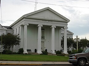
St. Martinville is a city in and the parish seat of St. Martin Parish, Louisiana, United States. It lies on Bayou Teche, 13 miles (21 km) south of Breaux Bridge, 16 miles (26 km) southeast of Lafayette, and 9 miles (14 km) north of New Iberia. The population was 6,114 at the 2010 U.S. census, and 5,379 at the 2020 United States census. It is part of the Lafayette metropolitan statistical area.

<span class="mw-page-title-main">Basile, Louisiana</span> Town in Louisiana, United States

Basile is a town in Acadia and Evangeline parishes in the U.S. state of Louisiana. The population was 1,214 in 2020.

<span class="mw-page-title-main">Delcambre, Louisiana</span> Town in Louisiana, United States

Delcambre is a town in Iberia and Vermilion parishes in the U.S. state of Louisiana, located 9 miles (14 km) east of Abbeville on Louisiana Highway 14 in the Cajun Heartland of Acadiana. Bayou Carlin, also known as the Delcambre Canal, passes through the town and is home for much of the local fishing industry. The population was 1,866 at the 2010 census, down from 2,168 at the 2000 census.

<span class="mw-page-title-main">Broussard, Louisiana</span> City in Louisiana, United States

Broussard is a city in Lafayette and St. Martin parishes in the U.S. state of Louisiana. The population was 8,197 at the 2010 U.S. census, and 13,417 at the 2020 United States census. Broussard is part of the Lafayette metropolitan statistical area.

<span class="mw-page-title-main">Arnaudville, Louisiana</span> Town in Louisiana, United States

Arnaudville is a town in St. Landry and St. Martin parishes in the U.S. state of Louisiana. The St. Martin Parish portion of Arnaudville is part of the Lafayette metropolitan statistical area, while the St. Landry Parish portion is part of the Opelousas–Eunice micropolitan statistical area. At the 2020 population estimates program, it had a population of 1,041.

<span class="mw-page-title-main">Lafayette–Opelousas–Morgan City combined statistical area</span>

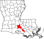
The Lafayette–Opelousas–Morgan City combined statistical area is made up of seven parishes in the Acadiana region of southern Louisiana. The statistical area consists of the Lafayette Metropolitan Statistical Area (MSA) and two micropolitical statistical areas (μSAs) – Opelousas, Louisiana Micropolitical Statistical Area and Morgan City, Louisiana Micropolitical Statistical Area. The region consists of seven parishes: Acadia, Iberia, Lafayette, St. Landry, St. Martin, St. Mary, and Vermilion Parishes. As of the 2010 census, the CSA had a population of 604,784.

Cade is a census-designated place (CDP) in St. Martin Parish, Louisiana, United States. At the 2014 census estimates, Cade had a population of 1,188; in 2019, the American Community Survey estimated its population was 1,655. With the 2020 U.S. census the population was 1874. The community is served by a single ZIP code: 70519.

References

  1. "Find a County". National Association of Counties. Retrieved June 7, 2011.
  2. "QuickFacts: St. Martin Parish, Louisiana". United States Census Bureau.
  3. 1 2 "St. Martin Parish History | St. Martin Parish Government". www.stmartinparish.net. Retrieved July 31, 2021.
  4. Perrin, William Henry (1891). Southwest Louisiana, biographical and historical. The Library of Congress. New Orleans : Gulf Publishing Co.
  5. "2010 Census Gazetteer Files". United States Census Bureau. August 22, 2012. Archived from the original on September 28, 2013. Retrieved September 1, 2014.
  6. Attakapas WMA- Retrieved 2017-02-19
  7. "U.S. Decennial Census". United States Census Bureau. Retrieved September 1, 2014.
  8. "Historical Census Browser". University of Virginia Library. Retrieved September 1, 2014.
  9. "Population of Counties by Decennial Census: 1900 to 1990". United States Census Bureau. Retrieved September 1, 2014.
  10. "Census 2000 PHC-T-4. Ranking Tables for Counties: 1990 and 2000" (PDF). United States Census Bureau. Archived (PDF) from the original on March 27, 2010. Retrieved September 1, 2014.
  11. "State & County QuickFacts". United States Census Bureau. Retrieved August 18, 2013.
  12. 1 2 "Explore Census Data". data.census.gov. Retrieved December 29, 2021.
  13. "U.S. Census website". United States Census Bureau . Retrieved January 31, 2008.
  14. 1 2 "Geography Profile: Saint Martin Parish, Louisiana". data.census.gov. Retrieved July 31, 2021.
  15. "Language Map Data Center". www.mla.org. Retrieved March 6, 2018.
  16. "Our Colleges". Louisiana's Technical and Community Colleges . Retrieved June 3, 2021.
  17. Leip, David. "Dave Leip's Atlas of U.S. Presidential Elections". uselectionatlas.org. Retrieved March 6, 2018.

Geology

30°08′N91°37′W / 30.13°N 91.61°W / 30.13; -91.61