Ponchatoula, Louisiana

Last updated

Ponchatoula, Louisiana
City of Ponchatoula
Ponchatoula Louisiana July 2013 03.jpg
Downtown Ponchatoula
Tangipahoa Parish Louisiana Incorporated and Unincorporated areas Ponchatoula Highlighted.svg
Location of Ponchatoula in Tangipahoa Parish, Louisiana.
Louisiana in United States (US48).svg
Location of Louisiana in the United States
Coordinates: 30°26′21″N90°26′33″W / 30.43917°N 90.44250°W / 30.43917; -90.44250
CountryUnited States
StateLouisiana
Parish Tangipahoa
Government
   Mayor Robert F. Zabbia [1]
Area
[2]
  Total4.74 sq mi (12.27 km2)
  Land4.73 sq mi (12.26 km2)
  Water0.00 sq mi (0.01 km2)
Elevation
26 ft (8 m)
Population
 (2020)
  Total7,822
  Density1,653.00/sq mi (638.20/km2)
Time zone UTC−6 (CST)
  Summer (DST) UTC−5 (CDT)
ZIP code
70454
Area code 985
FIPS code 22-61615
Website City of Ponchatoula, Louisiana

Ponchatoula is the second-largest city in Tangipahoa Parish, Louisiana. The population was 6,559 at the 2010 census and 7,545 at the time of the 2020 population estimates program. [3]

Contents

Etymology

It is speculated that the name is derived from the Choctaw words Pashi meaning "hair" and perhaps itula or itola meaning "to fall" or "to hang" or "flowing" in the Choctaw language [4]

History


PONCHATOULA ESTABLISHED

The city of Ponchatoula was founded when the railroad from Jackson, Mississippi to New Orleans was constructed through this area in the 1850's. The New Orleans, Jackson and Great Northern Railroad Company hired an experienced civil engineer, James B. Clarke (ca. 1809-1861) to survey the projected railroad route, establish railroad depot sites, buy timber for bridges and railroad ties, and do the other tasks necessary to construct the railroad.

Finding that there was an unclaimed section of land north of the Manchac swamp, Clarke located a railroad depot near the first dry land after leaving the swamp. Mr. Clarke purchased this one square mile section of land from the state of Louisiana in two installments in December 1852 and January 1853. He surveyed this land and laid out a town in 1853 using the familiar grid system with streets running east–west named for native trees, and north–south streets numbered one through nine. He called his new development "Ponchatoula" after the Ponchatoula River located a couple of miles west of the new settlement. Ponchatoula is a Choctaw word meaning "hanging hair" referring to the beautiful Spanish moss which drapes many of the local trees.

James Clarke began selling town lots, and soon several stores and dozens of homes were built nearby. Ponchatoula grew as new settlers moved here to be near the railroad line, "a new avenue of commerce." The small town was incorporated by the Louisiana legislature in February 1861. A few months after the incorporation of the town, the Civil War began with serious consequences for the community. Because Ponchatoula was located on the vital railroad line, military engagements happened here in September 1862 and March 1863. During the war, stores and some homes were looted, the train depot burned, and livestock killed and stolen.

When the war ended, the railroad line was repaired, a new train depot constructed, and tranquility returned to the little piney woods community. Through the following decades the town's population slowly grew with lumbering and agriculture being the primary local industries. Around 1900, the strawberry industry began to florish and Ponchatoula became an important shipping point for strawberries and vegetables. Hundreds of refrigerated railroad cars left Ponchatoula each spring loaded with strawberries for the northern markets.

The Ponchatoula community changed completely in 1921 when two large cypress lumbering companies located at the south edge of town. Hundreds of mill workers and their families arrived and the economy prospered with the increased population. The 1920s saw the construction of a new city hall and fire station, a new high school, a modern theater, improved street and municipal services, and dozens of new businesses. The prosperity of the 1920s ebbed as the hard times of the Depression arrived with the closing of the two lumber mills in 1929, and continued through the 1930's mirroring the national economic crisis. Ponchatoula's economy was aided during the Depression by the flourishing strawberry industry and the reopening of a cypress lumber company on one of the former mill sites.

During World War II, Ponchatoula stepped up and actively supported the war effort. Hundreds of local men and women entered the armed forces, war bond drives and several scrap drives were held, along with other war related activities. A scrap drive led by the local school children yielded a vast amount of iron needed to produce the weapons of war. The community's outstanding contribution to the war effort was recognized when the Navy launched an oil tanker named the USS Ponchatoula, which served in the Pacific. This vessel was scrapped after the war, but a new and much larger oil tanker was built in the 1950's and also named the USS Ponchatoula. The new vessel served with distinction for many years.

Ponchatoula continued to grow in the post war years and the economy became more diversified and less connected to the strawberry and lumbering industries.

In recent years Ponchatoula has become a tourist destination with a quaint historic district, and was designated as "America's Antique City." The community hosts the well-known Strawberry Festival, which attracts many thousands of visitors every April.

From a small piney woods town in the 1850's Ponchatoula has become a vibrant city offering many attractive activities while retaining the "home town" charm that makes so special.

[5]

Early 20th century

The Ponchatoula bank in the year 1912 Ponchatoula 1912 Bank.jpg
The Ponchatoula bank in the year 1912

The train depot which was destroyed during the Civil War was rebuilt in 1895 as the area began to recover from the Civil War. At the turn of the 20th century Ponchatoula began to transform from the lumber industry into a commercial farming community. The main street began filling up with beautiful brick buildings as shops, banks and restaurants were built to accommodate the growing population. The main crop grown by the local farmers was the strawberry. Many of the families who were major farmers during this era, which lasted about eighty years, have their last names engraved on a large plaque in front of city hall.

The Peoples Drug Store in the year 1912 Ponchatoula Louisiana 1912 Peoples Drug Store.jpg
The Peoples Drug Store in the year 1912

Geography

Ponchatoula is located at 30°26′21″N90°26′33″W / 30.43917°N 90.44250°W / 30.43917; -90.44250 (30.439162, -90.442507) [6] and has an elevation of 26 feet (7.9 m). [7] According to the United States Census Bureau, the city has a total area of 4.2 square miles (11 km2), all land.

Ponchatoula is located along Interstate 55 and Louisiana Highway 22, equidistant from New Orleans and Baton Rouge. In the early 1900s, Ponchatoula was one of only two ways to reach New Orleans by land, thus earning the moniker "Gateway to New Orleans."

Demographics

Historical population
CensusPop.Note
1870 320
1880 293−8.4%
1890 45956.7%
1900 71154.9%
1910 1,05548.4%
1920 955−9.5%
1930 2,898203.5%
1940 4,00138.1%
1950 4,0902.2%
1960 4,72715.6%
1970 4,545−3.9%
1980 5,46920.3%
1990 5,425−0.8%
2000 5,180−4.5%
2010 6,55926.6%
2020 7,82219.3%
U.S. Decennial Census [8]

2020 census

Ponchatoula racial composition [9]
RaceNumberPercentage
White (non-Hispanic)4,79961.35%
Black or African American (non-Hispanic)2,26728.98%
Native American 320.41%
Asian 520.66%
Pacific Islander 30.04%
Other/Mixed 3083.94%
Hispanic or Latino 3614.62%

As of the 2020 United States census, there were 7,822 people, 2,863 households, and 1,726 families residing in the city.

2000 census

As of the 2000 census, [10] there were 5,180 people, 1,984 households, and 1,372 families residing in the city. The population density was 1,226.7 inhabitants per square mile (473.6/km2). There were 2,175 housing units at an average density of 515.1 per square mile (198.9/km2). The racial makeup of the city was 62.20% White, 36.83% African American, 0.19% Native American, 0.12% Asian, 0.15% from other races, and 0.50% from two or more races. Hispanic or Latino of any race were 0.85% of the population.

There were 1,984 households, out of which 34.9% had children under the age of 18 living with them, 41.2% were married couples living together, 23.1% had a female householder with no husband present, and 30.8% were non-families. 27.1% of all households were made up of individuals, and 11.5% had someone living alone who was 65 years of age or older. The average household size was 2.60 and the average family size was 3.16.

In the city, the population was spread out, with 29.8% under the age of 18, 9.9% from 18 to 24, 26.9% from 25 to 44, 21.0% from 45 to 64, and 12.4% who were 65 years of age or older. The median age was 33 years. For every 100 females, there were 85.9 males. For every 100 females age 18 and over, there were 79.1 males.

The median income for a household in the city was $22,244, and the median income for a family was $29,583. Males had a median income of $30,285 versus $18,952 for females. The per capita income for the city was $12,157. About 27.9% of families and 31.7% of the population were below the poverty line, including 46.9% of those under age 18 and 15.1% of those age 65 or over.

Education

Tangipahoa Parish School System operates public schools:

Visitor attractions

Ponchatoula hosts Louisiana's Strawberry Festival each April and an Oktoberfest each autumn.

The town is noted for its many antique shops along Pine Street (LA 22), open year-round. Eleven of the Ponchatoula Commercial Historic District buildings are determined to be historically significant and listed on the National Register of Historic Places. Ponchatoula is small, but it has a number of attractions including a sign on the outskirts of town with how many miles it lies from South Dakota's Wall Drug store.

Across Highway 22 from Hardhide is the Collinswood School Museum, a former one-room schoolhouse which exhibits local artifacts and quilts. Between the school museum and the tracks stands the Strawberry Train, which is a steam engine and single passenger car roped off in such a way that children can safely climb into the engine and the car.

The Chamber of Commerce office is located on Highway 22 at the railroad tracks and has information about these and other sights in Ponchatoula and the surrounding area.

Strawberry Festival

The first Strawberry Festival was held in April 1972 on the first block of North 6th Street and was co-sponsored by the Ponchatoula Jaycees and the Ponchatoula Chamber of Commerce. The first festival was small and only had 11 booths. It was a two-day event beginning with a baseball game between Southeastern Louisiana University and Wisconsin State. Today it is the second largest event in the state, after Mardi Gras [ citation needed ]. During the 1980s the local economy changed to tourism, when farming no longer earned enough to sustain the town. The mayor at the time devised a plan to open antique shops where former businesses had been located. There are still about six of these shops in operation. This gave the town a second nickname, "America's Antique City."

Notable people

See also

Related Research Articles

<span class="mw-page-title-main">Washington Parish, Louisiana</span> Parish in Louisiana, United States

Washington Parish is a parish located in the interior southeast corner of the U.S. state of Louisiana, one of the Florida Parishes. As of the 2020 census, the population was 45,463. Its parish seat is Franklinton. Its largest city is Bogalusa. The parish was founded in 1819.

<span class="mw-page-title-main">Tangipahoa Parish, Louisiana</span> Parish in Louisiana, United States

Tangipahoa Parish is a parish located on the southeastern border of the U.S. state of Louisiana. As of the 2020 census, the population was 133,157. The parish seat is Amite City, while the largest city is Hammond. Southeastern Louisiana University is located in Hammond. Lake Pontchartrain borders the southeastern side of the parish.

<span class="mw-page-title-main">St. Tammany Parish, Louisiana</span> Parish in Louisiana, United States

St. Tammany Parish is a parish located in the U.S. state of Louisiana named after Tamanend, the legendary Lenape Chief of Chiefs and the "Patron Saint of America." At the 2020 census, the population was 264,570, making it the fourth-most populous parish in Louisiana. The parish seat is Covington. The parish was founded in 1810.

<span class="mw-page-title-main">Bald Knob, Arkansas</span> City in Arkansas, United States

Bald Knob is a city in White County, Arkansas, United States. The population was 2,897 at the 2010 census. Located at the intersection of two of the state's natural regions, Bald Knob is often promoted as "where the Ozarks meet the Delta". Bald Knob is known for its yearly Home Fest held during Mother's Day weekend. It was once known as the leading strawberry producer in the world in the 1950s. Bald Knob was established in 1881.

<span class="mw-page-title-main">Albany, Louisiana</span> Town in Louisiana

Albany is a town in eastern Livingston Parish, Louisiana, United States. The population was 1,088 at the 2010 census and 1,235 in 2020. It is part of the Baton Rouge metropolitan statistical area.

<span class="mw-page-title-main">Springfield, Louisiana</span> Town in Louisiana, United States

Springfield is a town in Livingston Parish, Louisiana, United States. The population was 487 at the 2010 census. It is part of the Baton Rouge metropolitan statistical area.

<span class="mw-page-title-main">Amite City, Louisiana</span> Town in Louisiana, United States

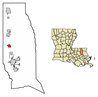
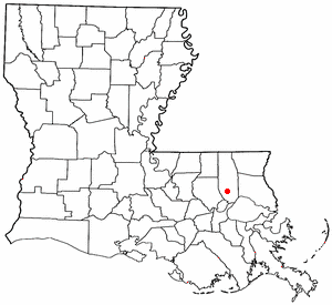
Amite City is a town in and the seat of Tangipahoa Parish in southeastern Louisiana, United States. The population was 4,141 at the 2010 census. It is part of the Hammond Micropolitan Statistical Area.

<span class="mw-page-title-main">Hammond, Louisiana</span> City in Louisiana, US

Hammond is the largest city in Tangipahoa Parish, Louisiana, United States, located 45 miles (72 km) east of Baton Rouge and 45 miles (72 km) northwest of New Orleans. Its population was 20,019 in the 2010 U.S. census, and 21,359 at the 2020 population estimates program.

<span class="mw-page-title-main">Independence, Louisiana</span> Town in Louisiana, United States

Independence, originally known as Uncle Sam, is a town in Tangipahoa Parish, Louisiana, United States. The population was 1,665 at the 2010 census. It is part of the Hammond Micropolitan Statistical Area.

<span class="mw-page-title-main">Kentwood, Louisiana</span> Town in Louisiana, United States

Kentwood is a rural town in Tangipahoa Parish, Louisiana, United States, near the Mississippi state line. The population was 2,198 at the 2010 census. It is part of the Hammond Micropolitan Statistical Area. Kentwood is best known as the hometown of singer Britney Spears.

<span class="mw-page-title-main">Bogalusa, Louisiana</span> City in Louisiana, United States

Bogalusa is a city in Washington Parish, Louisiana, United States. The population was 12,232 at the 2010 census. In the 2020 census the city reported a population of 10,659. It is the principal city of the Bogalusa Micropolitan Statistical Area, which includes all of Washington Parish and is also part of the larger New Orleans–Metairie–Hammond combined statistical area.

<span class="mw-page-title-main">Kiln, Mississippi</span> CDP in Hancock County, Mississippi, United States

Kiln is an unincorporated community and census-designated place (CDP) in Hancock County, Mississippi, United States. The town is located about 50 miles (80 km) northeast of New Orleans, Louisiana. It is part of the Gulfport-Biloxi Metropolitan Statistical Area. The population was 2,238 at the 2010 census.

<span class="mw-page-title-main">McAlester, Oklahoma</span> City in Oklahoma, United States

McAlester is the county seat of Pittsburg County, Oklahoma. The population was 18,363 at the time of the 2010 census, a 3.4 percent increase from 17,783 at the 2000 census. The town gets its name from James Jackson McAlester, an early white settler and businessman who later became lieutenant governor of Oklahoma. Known as "J. J.", McAlester married Rebecca Burney, the daughter of a full-blood Chickasaw family, which made him a citizen of the Chickasaw Nation.

<span class="mw-page-title-main">Manchac, Louisiana</span> Unincorporated community in Louisiana, United States

Manchac is an unincorporated community in Tangipahoa Parish, Louisiana, United States.

<span class="mw-page-title-main">Interstate 55 in Louisiana</span> Highway in Louisiana

Interstate 55 (I-55) is a part of the Interstate Highway System that spans 964.25 miles (1,551.81 km) from LaPlace, Louisiana, to Chicago, Illinois. Within the state of Louisiana, the highway travels 66 miles (106 km) from the national southern terminus at I-10 in LaPlace to the Mississippi state line north of Kentwood.

<span class="mw-page-title-main">U.S. Route 51 in Louisiana</span> Section of U.S. Highway in Louisiana, United States

U.S. Highway 51 (US 51) is a part of the United States Numbered Highway System that spans 1,277 miles (2,055 km) from LaPlace, Louisiana to a point north of Hurley, Wisconsin. Within the state of Louisiana, the highway travels 69.12 miles (111.24 km) from the national southern terminus at US 61 in LaPlace to the Mississippi state line north of Kentwood.

<span class="mw-page-title-main">Battle of Ponchatoula</span> Battle of the American Civil War

The Battle of Ponchatoula was a battle in Ponchatoula, Louisiana, and Ponchatoula Creek at the onset of the Vicksburg Campaign during the American Civil War. Fought from March 24 to March 26, 1863, the battle was part of an offensive campaign waged by the Union's 6th Michigan, 9th Connecticut, 14th Maine, 24th Maine, 165th New York Zouaves, and 77th New York infantry against Confederate troops to capture Ponchatoula for the Union and destroy the town's railroad bridge. This was ultimately a failure by the Union, as the outcome of the battle led to the Confederates regaining control of Ponchatoula.

Joyce Wildlife Management Area is a 42,292 acres (17,115 ha) protected area in Tangipahoa Parish, Louisiana, owned by the Louisiana Department of Wildlife and Fisheries. It is located 10 miles (16 km) south of Hammond and features a boardwalk leading into the swamps on the northwest corner.

<span class="mw-page-title-main">Expedition to Pass Manchac and Ponchatoula</span> Action of the American Civil War

The Expedition to Pass Manchac and Ponchatoula was a military engagement of the American Civil War that took place September 13–15, 1862 in and around Pass Manchac and Ponchatoula, Louisiana. The objective of the Union troops was to sabotage the Manchac bridge and to possibly capture Confederate Brig. Gen. M. Jeff Thompson to prevent a reprise attack from the Confederates into New Orleans. Union forces reached the town under fire from Confederate troops and ended up damaging the Manchac railroad bridge and burning 20 freight train cars after overwhelming the Confederate forces. The Confederate then regrouped with reinforcements and attacked the federal troops, forcing them back to New Orleans.

<span class="mw-page-title-main">Ponchatoula Commercial Historic District</span> United States historic place

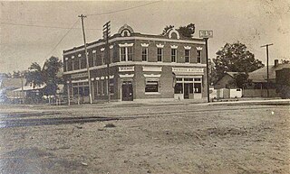
The Ponchatoula Commercial Historic District in Ponchatoula, Tangipahoa Parish, Louisiana, was listed on the National Register of Historic Places in 1982. Eleven of the early 20th century buildings have been determined to be historically significant.

References

  1. "Mayor's Office - City of Ponchatoula". cityofponchatoula.com. Retrieved January 6, 2020.
  2. "2020 U.S. Gazetteer Files". United States Census Bureau. Retrieved March 20, 2022.
  3. "City and Town Population Totals: 2010-2020". The United States Census Bureau. Retrieved November 27, 2021.
  4. Sandy Nestor (May 7, 2015). Indian Placenames in America. McFarland. pp. 74–. ISBN   978-0-7864-9339-5.
  5. Annual Report of the New Orleans, Jackson and Great Northern Railroad Company, 1860. DeBow's Review, James D. B. DeBow editor, Dec. 1849, Feb. 1850, Jan. 1851, Apr. 1852, Nov. 1852, Aug. 1853, July 1855. The Daily Picayune (New Orleans), 16 Sept. 1852, 22 Sept. 1852, 23 Dec. 1852, 14 July 1853. Tangipahoa Parish Deed Book: Livingston Number One. City of Ponchatoula: Minute Book 1. Ponchatoula, Louisiana: A Community History, James M. Perrin, 2020.
  6. "US Gazetteer files: 2010, 2000, and 1990". United States Census Bureau. February 12, 2011. Retrieved April 23, 2011.
  7. "US Board on Geographic Names". United States Geological Survey. October 25, 2007. Retrieved January 31, 2008.
  8. "Census of Population and Housing". census.gov. Retrieved June 4, 2015.
  9. "Explore Census Data". data.census.gov. Retrieved December 28, 2021.
  10. "U.S. Census website". United States Census Bureau . Retrieved January 31, 2008.
  11. "Former state representative Steve Pugh dies at age 60". WAFB . September 8, 2021. Archived from the original on September 15, 2021. Retrieved October 3, 2021.