Tangipahoa Parish is a parish located on the southeastern border of the U.S. state of Louisiana. As of the 2020 census, the population was 133,157. The parish seat is Amite City, while the largest city is Hammond. Southeastern Louisiana University is located in Hammond. Lake Pontchartrain borders the southeastern side of the parish.

St. Tammany Parish is a parish located in the U.S. state of Louisiana named after Tamanend, the legendary Lenape Chief of Chiefs and the "Patron Saint of America." At the 2020 census, the population was 264,570, making it the fourth-most populous parish in Louisiana. The parish seat is Covington. The parish was founded in 1810.

Springfield is a town in Livingston Parish, Louisiana, United States. The population was 487 at the 2010 census. It is part of the Baton Rouge metropolitan statistical area.

Hammond is the largest city in Tangipahoa Parish, Louisiana, United States, located 45 miles (72 km) east of Baton Rouge and 45 miles (72 km) northwest of New Orleans. Its population was 20,019 in the 2010 U.S. census, and 21,359 at the 2020 population estimates program.
Independence, originally known as Uncle Sam, is a town in Tangipahoa Parish, Louisiana, United States. The population was 1,665 at the 2010 census. It is part of the Hammond Micropolitan Statistical Area.

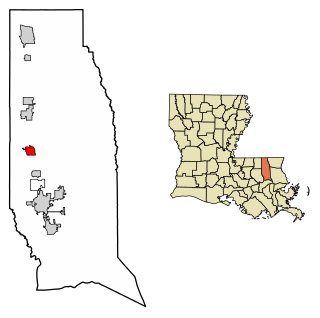
Ponchatoula is the second-largest city in Tangipahoa Parish, Louisiana. The population was 6,559 at the 2010 census and 7,545 at the time of the 2020 population estimates program.

Lake Pontchartrain is an estuary located in southeastern Louisiana in the United States. It covers an area of 630 square miles (1,600 km2) with an average depth of 12 to 14 feet. Some shipping channels are kept deeper through dredging. It is roughly oval in shape, about 40 miles (64 km) from west to east and 24 miles (39 km) from south to north.

Manchac is an unincorporated community in Tangipahoa Parish, Louisiana, United States.

Louisiana Highway 22 (LA 22) is a state highway located in southeastern Louisiana. It runs 71.15 miles (114.50 km) in a general east–west direction from the junction of LA 75 and LA 942 in Darrow to U.S. Highway 190 (US 190) in Mandeville.

Hammond High Magnet School, founded in 1866, is a public high school located in an unincorporated part of the 7th Ward of Tangipahoa Parish, Louisiana, United States, east of Hammond. It is the second-largest high school in the Tangipahoa Parish Public School System. Until the end of academic year 2010-11 it was known as Hammond High School but became Hammond Magnet High School on being so reconstituted and designated by the Tangipahoa Parish School System. The mascot is the Tornado, and the school colors are purple and white. As of the 2022-2023 school year, Hammond High's principal is Micheal Kyle. The school enrolls students from Hammond and the surrounding area within Tangipahoa Parish because of the presence of the Magnet program and International Baccalaureate program.

Interstate 55 (I-55) is a part of the Interstate Highway System that spans 964.25 miles (1,551.81 km) from LaPlace, Louisiana, to Chicago, Illinois. Within the state of Louisiana, the highway travels 66 miles (106 km) from the national southern terminus at I-10 in LaPlace to the Mississippi state line north of Kentwood.

Bolivar Edwards Kemp Sr., was an attorney and a member of the United States House of Representatives from Louisiana's 6th congressional district.
Loranger is an unincorporated community in Tangipahoa Parish, Louisiana, United States. Loranger is located East of Hammond, Louisiana, at the junction of LA 40 and LA 1062.

U.S. Highway 51 (US 51) is a part of the United States Numbered Highway System that spans 1,277 miles (2,055 km) from LaPlace, Louisiana to a point north of Hurley, Wisconsin. Within the state of Louisiana, the highway travels 69.12 miles (111.24 km) from the national southern terminus at US 61 in LaPlace to the Mississippi state line north of Kentwood.
Ponchatoula High School is a public high school in unincorporated Tangipahoa Parish, Louisiana, United States, near Ponchatoula. It is operated by the Tangipahoa Parish School System. Ponchatoula High School is one of the largest high schools in the state of Louisiana by student enrollment.

Ponchatoula Creek is a 26.1-mile-long (42.0 km) tributary of the Natalbany River in Tangipahoa Parish, Louisiana. The two waterways join where a section of the Natalbany forms the boundary between Tangipahoa Parish and Livingston Parish. Ponchatoula Creek originates west of Old US Highway 51, 1 mile (1.6 km) north of Independence. The creek is entirely within Tangipahoa Parish.
Lees Landing is an unincorporated community in Tangipahoa Parish, Louisiana, United States. The community is located 7 miles SE of Ponchatoula, Louisiana.
Osceola is an unincorporated community in Tangipahoa Parish, Louisiana, United States. The community is located 16 miles NW of Covington, Louisiana.
Sharkey is an unincorporated community in Tangipahoa Parish, Louisiana, United States. The community is located 5 miles S of Ponchatoula, Louisiana.
Strader is an unincorporated community in Tangipahoa Parish, Louisiana, United States. The community is located 8 miles S of Ponchatoula, Louisiana.


