
Pike County is a county located on the southwestern border of the U.S. state of Mississippi. As of the 2020 census, the population was 40,324. The county seat is Magnolia. Pike County is named for explorer Zebulon Pike. Pike County is part of the McComb, MS Micropolitan Statistical Area.

Washington Parish is a parish located in the interior southeast corner of the U.S. state of Louisiana, one of the Florida Parishes. As of the 2020 census, the population was 45,463. Its parish seat is Franklinton. Its largest city is Bogalusa. The parish was founded in 1819.
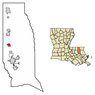
Tangipahoa Parish is a parish located on the southeastern border of the U.S. state of Louisiana. As of the 2020 census, the population was 133,157. The parish seat is Amite City, while the largest city is Hammond. Southeastern Louisiana University is located in Hammond. Lake Pontchartrain borders the southeastern side of the parish.

St. Tammany Parish is a parish located in the U.S. state of Louisiana named after Tamanend, the legendary Lenape Chief of Chiefs and the "Patron Saint of America." At the 2020 census, the population was 264,570, making it the fourth-most populous parish in Louisiana. The parish seat is Covington. The parish was founded in 1810.
St. John the Baptist Parish is a parish located in the U.S. state of Louisiana. At the 2020 census, the population was 42,477. The parish seat is Edgard, an unincorporated area, and the largest city is LaPlace, which is also unincorporated.

St. Helena Parish is a parish in the U.S. state of Louisiana. At the 2020 United States census, the population was 10,920. Its seat is Greensburg. The parish was created in 1810. St. Helena Parish is part of the Baton Rouge metropolitan area.

Amite City is a town in and the seat of Tangipahoa Parish in southeastern Louisiana, United States. The population was 4,141 at the 2010 census. It is part of the Hammond Micropolitan Statistical Area.

Hammond is the largest city in Tangipahoa Parish, Louisiana, United States, located 45 miles (72 km) east of Baton Rouge and 45 miles (72 km) northwest of New Orleans. Its population was 20,019 in the 2010 U.S. census, and 21,359 at the 2020 population estimates program.
Independence, originally known as Uncle Sam, is a town in Tangipahoa Parish, Louisiana, United States. The population was 1,665 at the 2010 census. It is part of the Hammond Micropolitan Statistical Area.

Osyka is a town in Pike County, Mississippi, United States. It is located on the Mississippi–Louisiana state line. The population was 440 at the 2010 census. It is part of the McComb, Mississippi Micropolitan Statistical Area. The peak of its population was in 1910.

Manchac is an unincorporated community in Tangipahoa Parish, Louisiana, United States.
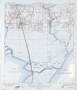
The Tangipahoa River originates northwest of McComb in southwest Mississippi, and runs south 122 miles (196 km) through Lake Tangipahoa in Percy Quin State Park before passing into southeast Louisiana. There it flows entirely in the eponymous Tangipahoa Parish until its mouth opens into the northwest region of Lake Pontchartrain.

U.S. Highway 51 (US 51) is a part of the United States Numbered Highway System that spans 1,277 miles (2,055 km) from LaPlace, Louisiana to a point north of Hurley, Wisconsin. Within the state of Louisiana, the highway travels 69.12 miles (111.24 km) from the national southern terminus at US 61 in LaPlace to the Mississippi state line north of Kentwood.
Hackley is an unincorporated community in Washington Parish, Louisiana, United States. The community is located 9 miles N of Franklinton, Louisiana.
Greenlaw is an unincorporated community in Tangipahoa Parish, Louisiana, United States. The community is located 17 miles N of Amite City, Louisiana.
Lees Landing is an unincorporated community in Tangipahoa Parish, Louisiana, United States. The community is located 7 miles SE of Ponchatoula, Louisiana.
Osceola is an unincorporated community in Tangipahoa Parish, Louisiana, United States. The community is located 16 miles NW of Covington, Louisiana.
Wadesboro is an unincorporated community in Tangipahoa Parish, Louisiana, United States. The community is located 2 miles southwest of Ponchatoula, Louisiana.
Magnolia, also known as Otts Mill, is an unincorporated community in Livingston Parish, Louisiana, United States. The community is located 5 miles northwest of Livingston and 2 miles west of Starns on Louisiana Highway 442 at the intersection with Louisiana Highway 1036.


