Alexandria is the ninth-largest city in the state of Louisiana and is the parish seat of Rapides Parish, Louisiana, United States. It lies on the south bank of the Red River in almost the exact geographic center of the state. It is the principal city of the Alexandria metropolitan area which encompasses all of Rapides and Grant parishes. Its neighboring city is Pineville. In 2010, the population was 47,723, an increase of 3 percent from the 2000 census.

Interstate 12 (I-12) is an Interstate Highway located entirely within the US state of Louisiana. It spans a total of 85.59 miles (137.74 km) in an east–west direction from I-10 in Baton Rouge to an interchange with both I-10 and I-59 in Slidell. Along the way, it passes through the city of Hammond, where it intersects I-55 and US Route 51 (US 51). It also serves the cities of Ponchatoula and Denham Springs, as well as the St. Tammany Parish cities of Covington and Mandeville. Skirting the northern shore of Lake Pontchartrain, I-12 serves as both a northern bypass of the New Orleans metropolitan area and an alternate route for I-10, which serves the city of New Orleans itself.
Tangipahoa Parish is a parish located on the southeastern border of the U.S. state of Louisiana. As of the 2020 census, the population was 133,157. The parish seat is Amite City, while the largest city is Hammond. Southeastern Louisiana University is located in Hammond. Lake Pontchartrain borders the southeastern side of the parish.

Metairie is a census-designated place (CDP) in Jefferson Parish, Louisiana, United States, and is part of the New Orleans metropolitan area. With a population of 143,507 in 2020, Metairie is the largest community in Jefferson Parish and was the fifth-largest CDP in the United States. It is an unincorporated area that would have been Louisiana's fourth-largest city behind Shreveport if incorporated.
Denham Springs is a city in Livingston Parish, Louisiana, United States. The 2010 U.S. census placed the population at 10,215, up from 8,757 at the 2000 U. S. census. At the 2020 United States census, 9,286 people lived in the city. The city is the largest area of commercial and residential development in Livingston Parish. Denham Springs and Walker are the only parish municipalities classified as cities. The area has been known as Amite Springs, Hill's Springs, and Denham Springs.

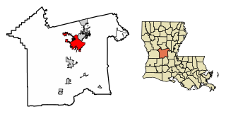
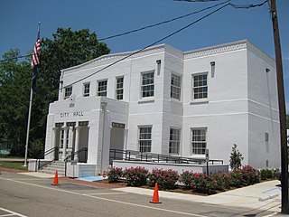
Amite City is a town in and the seat of Tangipahoa Parish in southeastern Louisiana, United States. The population was 4,141 at the 2010 census. It is part of the Hammond Micropolitan Statistical Area.

Hammond is the largest city in Tangipahoa Parish, Louisiana, United States, located 45 miles (72 km) east of Baton Rouge and 45 miles (72 km) northwest of New Orleans. Its population was 20,019 in the 2010 U.S. census, and 21,359 at the 2020 population estimates program.

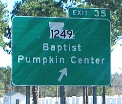
Ponchatoula is the second-largest city in Tangipahoa Parish, Louisiana. The population was 6,559 at the 2010 census and 7,545 at the time of the 2020 population estimates program.

Keene is the only city in and the seat of Cheshire County, New Hampshire, United States. The population was 23,047 at the 2020 census, down from 23,409 at the 2010 census.

Goffstown is a town in Hillsborough County, New Hampshire, United States. The population was 18,577 at the 2020 census. The compact center of town, where 3,366 people resided at the 2020 census, is defined by the U.S. Census Bureau as the Goffstown census-designated place and is located at the junctions of New Hampshire routes 114 and 13. Goffstown also includes the villages of Grasmere and Pinardville. The town is home to Saint Anselm College, the Goffstown Giant Pumpkin Regatta, and was the location of the New Hampshire State Prison for Women, prior to the prison's relocation to Concord in 2018.
Southeastern Louisiana University (Southeastern) is a public university in Hammond, Louisiana. It was founded in 1925 by Linus A. Sims as Hammond Junior College. Sims succeeded in getting the campus moved to north Hammond in 1928, when it became known as Southeastern Louisiana College. It achieved university status in 1970.

The New Orleans metropolitan area, designated the New Orleans–Metairie metropolitan statistical area by the U.S. Office of Management and Budget, or simply Greater New Orleans, is a metropolitan statistical area designated by the United States Census Bureau encompassing eight Louisiana parishes—the equivalent of counties in other U.S. states—centered on the city of New Orleans. The population of Greater New Orleans was 1,271,845 in 2020, up from 1,189,166 at the 2010 United States census. Greater New Orleans is the most populous metropolitan area in Louisiana, and the 45th most populous in the United States. According to 2017 census estimates, the broader New Orleans–Metairie–Hammond combined statistical area (CSA) had a population of 1,510,562.

Waterford is one of the Communities in Norfolk County, Ontario and had a population of 3,132 at the time of the 2016 Census.

U.S. Highway 51 (US 51) is a part of the United States Numbered Highway System that spans 1,277 miles (2,055 km) from LaPlace, Louisiana to a point north of Hurley, Wisconsin. Within the state of Louisiana, the highway travels 69.12 miles (111.24 km) from the national southern terminus at US 61 in LaPlace to the Mississippi state line north of Kentwood.
Pumpkin Center is an unincorporated community in Okmulgee County, Oklahoma, United States. It is approximately 10 miles northeast of the city of Okmulgee, taking N 330 Rd. north off US Highway 62.
Pumpkin Center is an unincorporated community in Comanche County, Oklahoma, United States. It is located at the intersection of state highways 7 and 65, approximately 10 miles east of Lawton in the southwestern portion of the state.

The Southeastern Louisiana Lions and Lady Lions are composed of 14 teams representing Southeastern Louisiana University in intercollegiate athletics, competing in the NCAA Division I Football Championship Subdivision (FCS) and are members of the Southland Conference.
Corbin is an unincorporated community in Livingston Parish, Louisiana, United States. The community is located 6 miles east of Denham Springs and 6 miles west of Livingston.
John Jacob Desmond was an architect from Hammond and Baton Rouge, Louisiana.