Manchac, Louisiana

Last updated

Manchac, Louisiana
Manchac Pass at North Pass looking north.jpg
This view toward the north from midstream in Pass Manchac shows its confluence with North Pass (center).
USA Louisiana location map.svg
Red pog.svg
Manchac, Louisiana
Location of Manchac in Louisiana
Coordinates: 30°17′30″N90°24′07″W / 30.29167°N 90.40194°W / 30.29167; -90.40194
CountryUnited States
StateLouisiana
Parish Tangipahoa
Elevation
3 ft (0.9 m)
Time zone UTC-6 (CST)
  Summer (DST) UTC-5 (CDT)
ZIP code
70421 [1]
Area code 985
Historical marker in Manchac (Akers), Louisiana Manchac historical marker.jpg
Historical marker in Manchac (Akers), Louisiana
Middendorf Restaurant is, as of 2012, actually a sequence of three restaurants along old United States Highway 51. The view is toward the south. Manchac Middendorf.jpg
Middendorf Restaurant is, as of 2012, actually a sequence of three restaurants along old United States Highway 51. The view is toward the south.

Manchac (also known as Akers) is an unincorporated community in Tangipahoa Parish, Louisiana, United States.

Contents

Etymology

Dr. John R. Swanton, a linguist who worked with Native American languages, suggested that the name Manchac is derived from Imashaka, which is a Choctaw word meaning "the rear entrance." [2] [3] An early Choctaw language dictionary written by Cyrus Byington defines the word im as a preposition meaning "place" and ashaka meaning "the back side or rear" [4]

Willie Akers

Willie Akers carried the same name as his father who founded the city of Ponchatoula. In the year 1871 Willie moved to Manchac with his family and built a house near a section of high ground that the locals called Jones Island. Then in the year 1857 Willie was appointed as the first postmaster of Manchac and served as the local telegraph operator. The local community became known as "Akers" during this period. [5]

History

Fort Bute or Manchac Post, named after the then British Prime Minister John Stuart, 3rd Earl of Bute, was established in 1763 at the junction of Iberville River (Bayou Manchac) with the Mississippi River, and remained an important military and trading post in British West Florida until captured by Spanish forces under Luis de Unzaga who built a new fort, Manchak fort, in August of 1775; [6] later, his brother-in-law Bernardo Galvez captured Manchac Fort from English again on September 7, 1779, during what became known as the Battle of Fort Bute of the American Revolutionary War. Manchac was raided in February 1778 by American forces under the command of James Willing [7] —see related articles, Continental Marines and USS Morris. Fort Bute/Manchac Post/Mississippi River at Bayou Manchac is 45 miles from Manchac.

The British used Manchac as a trading post with which the British agent in 1772 was reported to attempt to recruit a translator of Quapaw to undermine Spanish authority in Spanish Louisiana. Apparently it was a favorite object of deputy Indian agent John Thomas there. [8]

When the New Orleans, Jackson and Great Northern railroad was commissioned in 1852, Manchac was one of the stations originally planned, which were generally at ten-mile intervals. [9] Willie Akers' father, William Akers, was the founder and first mayor of the town of Ponchatoula, the next station to the north. Manchac straddles the railway, which, at the start of the 21st century, is part of the Canadian National Railway system.

The area was part of the Expedition to Pass Manchac and Ponchatoula during the American Civil War.

Location

Manchac is located on Lake Maurepas on the Pass Manchac waterway, which connects to Lake Pontchartrain. The Manchac Swamp Bridge on Interstate 55 has exit and entrance ramps for Manchac. Also located here is the Port Manchac Distribution Center, with storage facilities and rail, truck, and water links to the east, west, and north.

Manchac is home to the ruins of one of the five lighthouses set up for Lake Pontchartrain, the Pass Manchac Light. The last lighthouse to be built on the north side of the entrance to Pass Manchac (the fourth one on that site) was completed in 1857. It was automated in 1941, and the dwelling was razed in 1952; the U.S. Coast Guard decommissioned the light and abandoned the property in 1987. [10]

Hurricane Isaac destroyed the Pass Manchac Light structure in August 2012. However, the lantern room had previously been removed from the tower, for restoration purposes. Since 2008, Pass Manchac Light's lantern room has been located at the Lake Pontchartrain Basin Maritime Museum in Madisonville. [11]

Manchac is known for fishing, duck hunting, seafood restaurants such as Middendorf's, and swamp tours.

Related Research Articles

<span class="mw-page-title-main">Tangipahoa Parish, Louisiana</span> Parish in Louisiana, United States

Tangipahoa Parish is a parish located on the southeastern border of the U.S. state of Louisiana. As of the 2020 census, the population was 133,157. The parish seat is Amite City, while the largest city is Hammond. Southeastern Louisiana University is located in Hammond. Lake Pontchartrain borders the southeastern side of the parish.

<span class="mw-page-title-main">Ascension Parish, Louisiana</span> Parish in Louisiana, United States

Ascension Parish is a parish located in the U.S. state of Louisiana. As of the 2020 census, the population was 126,500. Its parish seat is Donaldsonville. The parish was created in 1807. Ascension Parish is part of the Baton Rouge metropolitan statistical area.

<span class="mw-page-title-main">Springfield, Louisiana</span> Town in Louisiana, United States

Springfield is a town in Livingston Parish, Louisiana, United States. The population was 487 at the 2010 census. It is part of the Baton Rouge metropolitan statistical area.

<span class="mw-page-title-main">Ponchatoula, Louisiana</span> City in Louisiana

Ponchatoula is the second-largest city in Tangipahoa Parish, Louisiana. The population was 6,559 at the 2010 census and 7,545 at the time of the 2020 population estimates program.

<span class="mw-page-title-main">Lake Pontchartrain</span> Estuary located in southeastern Louisiana, United States

Lake Pontchartrain is an estuary located in southeastern Louisiana in the United States. It covers an area of 630 square miles (1,600 km2) with an average depth of 12 to 14 feet. Some shipping channels are kept deeper through dredging. It is roughly oval in shape, about 40 miles (64 km) from west to east and 24 miles (39 km) from south to north.

<span class="mw-page-title-main">Capture of Fort Bute</span>

The Capture of Fort Bute signalled the opening of Spanish intervention in the American Revolutionary War on the side of France and the United States. Mustering an ad hoc army of Spanish regulars, Acadian militia, and native levies under Gilbert Antoine de St. Maxent, Bernardo de Gálvez, the Governor of Spanish Louisiana stormed and captured the small British frontier post on Bayou Manchac on September 7, 1779.

<span class="mw-page-title-main">Tchefuncte River</span> River in Louisiana

The Tchefuncte River drains into Lake Pontchartrain in Louisiana in the United States. It is about 70.0 miles (112.7 km) long.

<span class="mw-page-title-main">Spanish Fort (New Orleans)</span> United States historic place

Spanish Fort, also known as Old Spanish Fort, Fort St. Jean, and Fort St. John, is a historic place in New Orleans, Louisiana, formerly the site of a fort and later an amusement park.

Spanish Lake is located in the Bluff Swamp on the Iberville - Ascension Parish line.

<span class="mw-page-title-main">Louisiana Highway 22</span>

Louisiana Highway 22 (LA 22) is a state highway located in southeastern Louisiana. It runs 71.15 miles (114.50 km) in a general east–west direction from the junction of LA 75 and LA 942 in Darrow to U.S. Highway 190 (US 190) in Mandeville.

<span class="mw-page-title-main">Interstate 55 in Louisiana</span> Highway in Louisiana

Interstate 55 (I-55) is a part of the Interstate Highway System that spans 964.25 miles (1,551.81 km) from LaPlace, Louisiana, to Chicago, Illinois. Within the state of Louisiana, the highway travels 66 miles (106 km) from the national southern terminus at I-10 in LaPlace to the Mississippi state line north of Kentwood.

<span class="mw-page-title-main">Louisiana Highway 1077</span>

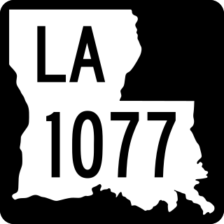
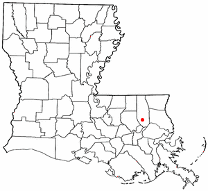
Louisiana Highway 1077 (LA 1077) is a state highway located in southeastern Louisiana. It runs 20.61 miles (33.17 km) in a general north–south direction from a dead end at Lake Pontchartrain in Madisonville to a junction with LA 25 south of Folsom.

Bayou Manchac is an 18-mile-long (29 km) bayou in southeast Louisiana, USA. First called the Iberville River by its French discoverers, the bayou was once a very important waterway linking the Mississippi River to the Amite River. East Baton Rouge Parish lies on its northern side, while its southern side is divided between Ascension Parish and Iberville Parish. The large unincorporated community of Prairieville and the city of St. Gabriel both lie on its southern side.

<span class="mw-page-title-main">U.S. Route 51 in Louisiana</span> Section of U.S. Highway in Louisiana, United States

U.S. Highway 51 (US 51) is a part of the United States Numbered Highway System that spans 1,277 miles (2,055 km) from LaPlace, Louisiana to a point north of Hurley, Wisconsin. Within the state of Louisiana, the highway travels 69.12 miles (111.24 km) from the national southern terminus at US 61 in LaPlace to the Mississippi state line north of Kentwood.

<span class="mw-page-title-main">Pass Manchac Light</span> Former lighthouse in Louisiana, United States

Pass Manchac Light was a historic lighthouse in Tangipahoa Parish, Louisiana, which was originally established in 1838, to mark the north side of the entrance to Pass Manchac, the channel between Lake Pontchartrain and Lake Maurepas. The fourth and last tower on this particular site was constructed in 1857 and was in service for 130 years. The first three had been built in 1838, 1842, and 1846, in each case requiring replacement due to poor construction and/or encroaching lake waters.

<span class="mw-page-title-main">Battle of Ponchatoula</span> Battle of the American Civil War

The Battle of Ponchatoula was a battle in Ponchatoula, Louisiana, and Ponchatoula Creek at the onset of the Vicksburg Campaign during the American Civil War. Fought from March 24 to March 26, 1863, the battle was part of an offensive campaign waged by the Union's 6th Michigan, 9th Connecticut, 14th Maine, 24th Maine, 165th New York Zouaves, and 77th New York infantry against Confederate troops to capture Ponchatoula for the Union and destroy the town's railroad bridge. This was ultimately a failure by the Union, as the outcome of the battle led to the Confederates regaining control of Ponchatoula.

Joyce Wildlife Management Area is a 34,520 acres (13,970 ha) protected area in Tangipahoa Parish, Louisiana, owned by the Louisiana Department of Wildlife and Fisheries. It is located 10 miles (16 km) south of Hammond and features a boardwalk leading into the swamps on the northwest corner.

<span class="mw-page-title-main">Fort Bute</span> Historic site in now East Baton Rouge Parish, Louisiana

Fort Bute (1766–1779) was a colonial fort built by the British in 1766 to protect the confluence of Bayou Manchac with the Mississippi River and was named in honor of the Earl of Bute. Fort Bute was located on Bayou Manchac, about 115 miles (185 km) up the Mississippi River from New Orleans, on the far western border of British West Florida. It was one of the three outposts maintained by the British in the lower Mississippi along with Fort Panmure and the Baton Rouge outpost.

<span class="mw-page-title-main">Expedition to Pass Manchac and Ponchatoula</span> Action of the American Civil War

The Expedition to Pass Manchac and Ponchatoula was a military engagement of the American Civil War that took place September 13–15, 1862 in and around Pass Manchac and Ponchatoula, Louisiana. The objective of the Union troops was to sabotage the Manchac bridge and to possibly capture Confederate Brig. Gen. M. Jeff Thompson to prevent a reprise attack from the Confederates into New Orleans. Union forces reached the town under fire from Confederate troops and ended up damaging the Manchac railroad bridge and burning 20 freight train cars after overwhelming the Confederate forces. The Confederate then regrouped with reinforcements and attacked the federal troops, forcing them back to New Orleans.

References

  1. "Akers ZIP Code". zipdatamaps.com. 2022. Retrieved November 11, 2022.
  2. William A. Read (October 12, 2008). Louisiana Place Names of Indian Origin: A Collection of Words. University of Alabama Press. p. 40. ISBN   978-0-8173-5505-0.
  3. Clare D’Artois Leeper (October 19, 2012). Louisiana Place Names: Popular, Unusual, and Forgotten Stories of Towns, Cities, Plantations, Bayous, and Even Some Cemeteries. LSU Press. pp. 156–. ISBN   978-0-8071-4738-2.
  4. Cyrus Byington (1915), A Dictionary of the Choctaw Language, Native American Book Publishers, p. 59, ISBN   9781878592071
  5. "Tennent Family, Tangipahoa Parish, Louisiana". usgwarchives.net. Retrieved September 19, 2020.
  6. Cazorla, Frank (2919). The governor Louis de Unzaga (1717-1793) Pioneer in the Birth of the United States of America and in Liberalism, Foundation Malaga, pages 42-56, 63, 82-83
  7. Arthur H. DeRosier, Jr.: William Dunbar: scientific pioneer of the old Southwest , University Press of Kentucky, Lexington, Ky., 2007, pp. 39-44
  8. Arnold, Morris S. (2000). The Rumble of a Distant Drum. University of Arkansas Press. p. 93. ISBN   1-55728-839-9.
  9. "New Orleans, Jackson, and Great Northern Stations". Confederate Railroads. Retrieved May 1, 2021.
  10. Lighthousefriends.com: Pass Manchac, LA, http://www.lighthousefriends.com/light.asp?ID=809, accessed 1 Jun 2010.
  11. Pass Manchac at LighthouseFriends.com accessed 25 Mar 2015.