Swamp

Last updated
A freshwater swamp in Florida, United States Florida freshwater swamp usgov image.jpg
A freshwater swamp in Florida, United States

A swamp is a forested wetland. [1] Swamps are considered to be transition zones because both land and water play a role in creating this environment. [2] Swamps vary in size and are located all around the world. The water of a swamp may be fresh water, brackish water, or seawater. Freshwater swamps form along large rivers or lakes where they are critically dependent upon rainwater and seasonal flooding to maintain natural water level fluctuations. [2] [3] Saltwater swamps are found along tropical and subtropical coastlines. [4] Some swamps have hammocks, or dry-land protrusions, covered by aquatic vegetation, or vegetation that tolerates periodic inundation [5] or soil saturation. The two main types of swamp are "true" or swamp forests and "transitional" or shrub swamps. In the boreal regions of Canada, the word swamp is colloquially used for what is more formally termed a bog, fen, or muskeg. Some of the world's largest swamps are found along major rivers such as the Amazon, the Mississippi, and the Congo. [6]

Contents

Differences between marshes and swamps

Difference between swamp and marsh USGS image cropped.jpg
Difference between swamp and marsh

Swamps and marshes are specific types of wetlands that form along waterbodies containing rich, hydric soils. [7] Marshes are wetlands, continually or frequently flooded by nearby running bodies of water, that are dominated by emergent soft-stem vegetation and herbaceous plants. Swamps are wetlands consisting of saturated soils or standing water and are dominated by water-tolerant woody vegetation such as shrubs, bushes, and trees. [8] [4]

Hydrology

Swamps are characterized by their saturated soils and slow-moving waters. [8] The water that accumulates in swamps comes from a variety of sources including precipitation, groundwater, tides and/or freshwater flooding. [4] These hydrologic pathways all contribute to how energy and nutrients flow in and out of the ecosystem. As water flows through the swamp, nutrients, sediment and pollutants are naturally filtered out. Chemicals like phosphorus and nitrogen that end up in waterways get absorbed and used by the aquatic plants within the swamp, purifying the water. Any remaining or excess chemicals present will accumulate at the bottom of the swamp, being removed from the water and buried within the sediment. [2] The biogeochemical environment of a swamp is dependent on its hydrology, affecting the levels and availability of resources like oxygen, nutrients, water pH and toxicity, which will influence the whole ecosystem. [4]

Values and ecosystem services

The Linnaistensuo Mire, a nature reserve swamp in Lahti, Finland. Linnaistensuo swamp, Lahti, Finland.jpg
The Linnaistensuo Mire, a nature reserve swamp in Lahti, Finland.

Swamps and other wetlands have traditionally held a very low property value compared to fields, prairies, or woodlands. They have a reputation for being unproductive land that cannot easily be utilized for human activities, other than hunting, trapping, or fishing. Farmers, for example, typically drained swamps next to their fields so as to gain more land usable for planting crops, both historically, and to a lesser extent, presently. On the other hand, swamps can (and do) play a beneficial ecological role in the overall functions of the natural environment and provide a variety of resources that many species depend on. Swamps and other wetlands have shown to be a natural form of flood management and defense against flooding. In such circumstances where flooding does occur, swamps absorb and use the excess water within the wetland, preventing it from traveling and flooding surrounding areas. [2] Dense vegetation within the swamp also provides soil stability to the land, holding soils and sediment in place whilst preventing erosion and land loss. Swamps are an abundant and valuable source of fresh water and oxygen for all life, and they are often breeding grounds for a wide variety of species. Floodplain swamps are an important resource in the production and distribution of fish. [10] Two thirds of global fish and shellfish are commercially harvested and dependent on wetlands. [2]

Impacts and conservation

Historically, humans have been known to drain and/or fill swamps and other wetlands in order to create more space for human development and to reduce the threat of diseases borne by swamp insects. Wetlands are removed and replaced with land that is then used for things like agriculture, real estate, and recreational uses. Many swamps have also undergone intensive logging and farming, requiring the construction of drainage ditches and canals. These ditches and canals contributed to drainage and, along the coast, allowed salt water to intrude, converting swamps to marsh or even to open water. [1] Large areas of swamp were therefore lost or degraded. Louisiana provides a classic example of wetland loss from these combined factors. [11] Europe has likely lost nearly half its wetlands. [12] New Zealand lost 90 percent of its wetlands over a period of 150 years. [13] Ecologists recognize that swamps provide ecological services including flood control, fish production, water purification, carbon storage, and wildlife habitats. [1] In many parts of the world authorities protect swamps. In parts of Europe and North America, swamp restoration projects are becoming widespread. [3] [14] The United States government began enforcing stricter laws and management programs in the 1970s in efforts to protect and restore these ecosystems. [2] Often the simplest steps to restoring swamps involve plugging drainage ditches and removing levees. [1]

Conservationists work to preserve swamps such as those in northwest Indiana in the United States Midwest that were preserved as part of the Indiana Dunes. [15] [16] [17]

Notable examples

Swamps can be found on all continents except Antarctica. [18]

The largest swamp in the world is the Amazon River floodplain, which is particularly significant for its large number of fish and tree species. [19] [20] [21]

Africa

The Sudd and the Okavango Delta [22] [23] are Africa's best known marshland areas. The Bangweulu Floodplains make up Africa's largest swamp.

Asia

Marsh Arabs poling a mashoof Marsh Arabs in a mashoof.jpg
Marsh Arabs poling a mashoof

The Mesopotamian Marshes [24] is a large swamp and river system in southern Iraq, traditionally inhabited in part by the Marsh Arabs.

In Asia, tropical peat swamps are located in mainland East Asia and Southeast Asia. In Southeast Asia, peatlands are mainly found in low altitude coastal and sub-coastal areas and extend inland for distance more than 100 km (62 mi) along river valleys and across watersheds. They are mostly to be found on the coasts of East Sumatra, Kalimantan (Central, East, South and West Kalimantan provinces), West Papua, Papua New Guinea, Brunei, Peninsular Malaya, Sabah, Sarawak, Southeast Thailand, and the Philippines (Riley et al.,1996). Indonesia has the largest area of tropical peatland. Of the total 440,000 km2 (170,000 sq mi) tropical peat swamp, about 210,000 km2 (81,000 sq mi) are located in Indonesia (Page, 2001; Wahyunto, 2006).

The Vasyugan Swamp is a large swamp in the western Siberia area of the Russian Federation. This is one of the largest swamps in the world, covering an area larger than Switzerland.

North America

Swamp in southern Louisiana Cypresses.jpg
Swamp in southern Louisiana

The Atchafalaya Swamp at the lower end of the Mississippi River is the largest swamp in the United States. It is an important example of southern cypress swamp [25] but it has been greatly altered by logging, drainage and levee construction. [26] Other famous swamps in the United States are the forested portions of the Everglades, Okefenokee Swamp, Barley Barber Swamp, Great Cypress Swamp and the Great Dismal Swamp. The Okefenokee is located in extreme southeastern Georgia and extends slightly into northeastern Florida. The Great Cypress Swamp is mostly in Delaware, but extends into Maryland on the Delmarva Peninsula. Point Lookout State Park on the southern tip of Maryland contains a large amount of swamps and marshes. The Great Dismal Swamp lies in extreme southeastern Virginia and extreme northeastern North Carolina. Both are National Wildlife Refuges. Another swamp area, Reelfoot Lake of extreme western Tennessee and Kentucky, was created by the 1811–12 New Madrid earthquakes. Caddo Lake, the Great Dismal and Reelfoot are swamps that are centered at large lakes. Swamps are often associated with bayous in the southeastern United States, especially in the Gulf Coast region. A baygall is a type of swamp found in the forest of the Gulf Coast states in the USA. [27] [28] [29]

List of major swamps

A small swamp in Padstow, New South Wales, Australia Saltpancrk12.jpg
A small swamp in Padstow, New South Wales, Australia
Inside a mangrove canopy, Salt Pan Creek, New South Wales Saltpancrk1a.jpg
Inside a mangrove canopy, Salt Pan Creek, New South Wales

The world's largest wetlands include significant areas of swamp, such as in the Amazon and Congo River basins. [21] Further north, however, the largest wetlands are bogs.

Africa

Asia

Australia

Europe

A black alder swamp in Germany Briesetal bei Briese.JPG
A black alder swamp in Germany

North America

South America

Pantanal in Brazil Pantanal, Mato Grosso, Brasil.jpg
Pantanal in Brazil

See also

Related Research Articles

<span class="mw-page-title-main">Everglades</span> Flooded grassland in Florida, United States

The Everglades is a natural region of flooded grasslands in the southern portion of the U.S. state of Florida, comprising the southern half of a large drainage basin within the Neotropical realm. The system begins near Orlando with the Kissimmee River, which discharges into the vast but shallow Lake Okeechobee. Water leaving the lake in the wet season forms a slow-moving river 60 miles (97 km) wide and over 100 miles (160 km) long, flowing southward across a limestone shelf to Florida Bay at the southern end of the state. The Everglades experiences a wide range of weather patterns, from frequent flooding in the wet season to drought in the dry season. Throughout the 20th century, the Everglades suffered significant loss of habitat and environmental degradation.

<span class="mw-page-title-main">Wetland</span> Land area that is permanently, or seasonally saturated with water

A wetland is a distinct ecosystem that is flooded or saturated by water, either permanently for years or decades or seasonally for a shorter periods. Flooding results in oxygen-free anoxic processes prevailing, especially in the soils. The primary factor that distinguishes wetlands from terrestrial land forms or water bodies is the characteristic vegetation of aquatic plants, adapted to the unique anoxic hydric soils. Wetlands are considered among the most biologically diverse of all ecosystems, serving as home to a wide range of plant and animal species. Methods for assessing wetland functions, wetland ecological health, and general wetland condition have been developed for many regions of the world. These methods have contributed to wetland conservation partly by raising public awareness of the functions some wetlands provide. Constructed wetlands are designed and built to treat municipal and industrial wastewater as well as to divert stormwater runoff. Constructed wetlands may also play a role in water-sensitive urban design.

<span class="mw-page-title-main">Fen</span> Type of wetland fed by mineral-rich ground or surface water

A fen is a type of peat-accumulating wetland fed by mineral-rich ground or surface water. It is one of the main types of wetlands along with marshes, swamps, and bogs. Bogs and fens, both peat-forming ecosystems, are also known as mires. The unique water chemistry of fens is a result of the ground or surface water input. Typically, this input results in higher mineral concentrations and a more basic pH than found in bogs. As peat accumulates in a fen, groundwater input can be reduced or cut off, making the fen ombrotrophic rather than minerotrophic. In this way, fens can become more acidic and transition to bogs over time.

<span class="mw-page-title-main">Bog</span> Type of wetland with peat-rich soil

A bog or bogland is a wetland that accumulates peat as a deposit of dead plant materials – often mosses, typically sphagnum moss. It is one of the four main types of wetlands. Other names for bogs include mire, mosses, quagmire, and muskeg; alkaline mires are called fens. A bayhead is another type of bog found in the forest of the Gulf Coast states in the United States. They are often covered in heath or heather shrubs rooted in the sphagnum moss and peat. The gradual accumulation of decayed plant material in a bog functions as a carbon sink.

<span class="mw-page-title-main">Marsh</span> Low-lying and seasonally waterlogged land

In ecology, a marsh is a wetland that is dominated by herbaceous plants rather than by woody plants. More in general, the word can be used for any low-lying and seasonally waterlogged terrain. In Europe and in agricultural literature low-lying meadows that require draining and embanked polderlands are also referred to as marshes or marshland.

<span class="mw-page-title-main">Lake Pontchartrain</span> Estuary located in southeastern Louisiana, United States

Lake Pontchartrain is an estuary located in southeastern Louisiana in the United States. It covers an area of 630 square miles (1,600 km2) with an average depth of 12 to 14 feet. Some shipping channels are kept deeper through dredging. It is roughly oval in shape, about 40 miles (64 km) from west to east and 24 miles (39 km) from south to north.

<span class="mw-page-title-main">Pearl River (Mississippi–Louisiana)</span> River in Mississippi and Louisiana, United States

The Pearl River is a river in the U.S. states of Mississippi and Louisiana. It forms in Neshoba County, Mississippi from the confluence of Nanih Waiya and Tallahaga creeks, and has a meander length of 444 miles (715 km). The lower part of the river forms part of the boundary between Mississippi and Louisiana.

<span class="mw-page-title-main">Wetlands of Louisiana</span>

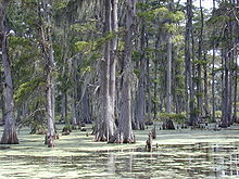
The wetlands of Louisiana are water-saturated coastal and swamp regions of southern Louisiana, often called 'Bayou'.

<span class="mw-page-title-main">Atchafalaya Basin</span> Largest wetland and swamp in the United States

The Atchafalaya Basin, or Atchafalaya Swamp, is the largest wetland and swamp in the United States. Located in south central Louisiana, it is a combination of wetlands and river delta area where the Atchafalaya River and the Gulf of Mexico converge. The river stretches from near Simmesport in the north through parts of eight parishes to the Morgan City southern area.

<span class="mw-page-title-main">Freshwater swamp forest</span> Forest growing on an alluvial zone

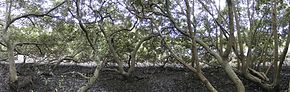
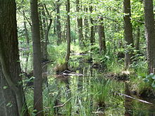
Freshwater swamp forests, or flooded forests, are forests which are inundated with freshwater, either permanently or seasonally. They normally occur along the lower reaches of rivers and around freshwater lakes. Freshwater swamp forests are found in a range of climate zones, from boreal through temperate and subtropical to tropical.

<span class="mw-page-title-main">Pocosin</span> Kind of wetland of the Atlantic plain

Pocosin is a type of palustrine wetland with deep, acidic, sandy, peat soils. Groundwater saturates the soil except during brief seasonal dry spells and during prolonged droughts. Pocosin soils are nutrient-deficient (oligotrophic), especially in phosphorus.

<span class="mw-page-title-main">Wet meadow</span>

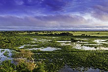
A wet meadow is a type of wetland with soils that are saturated for part or all of the growing season which prevents the growth of trees and brush. Debate exists whether a wet meadow is a type of marsh or a completely separate type of wetland. Wet prairies and wet savannas are hydrologically similar.

<span class="mw-page-title-main">Geography and ecology of the Everglades</span> Details of the natural environment of the Everglades

Before drainage, the Everglades, a region of tropical wetlands in southern Florida, were an interwoven mesh of marshes and prairies covering 4,000 square miles (10,000 km2). The Everglades is both a vast watershed that has historically extended from Lake Okeechobee 100 miles (160 km) south to Florida Bay, and many interconnected ecosystems within a geographic boundary. It is such a unique meeting of water, land, and climate that the use of either singular or plural to refer to the Everglades is appropriate. When Marjory Stoneman Douglas wrote her definitive description of the region in 1947, she used the metaphor "River of Grass" to explain the blending of water and plant life.

Lake Ophelia National Wildlife Refuge was established in 1988 to protect the Mississippi/Red River floodplain ecosystem. The refuge is located in Avoyelles Parish, Louisiana, east central Louisiana. The refuge is named for its most prominent water body, the 350-acre (1.4 km2) Lake Ophelia that was at one time a channel of the nearby Red River of the South.

Classification of wetlands has been a problematical task, with the commonly accepted definition of what constitutes a wetland being among the major difficulties. A number of national wetland classifications exist. In the 1970s, the Ramsar Convention on Wetlands of International Importance introduced a first attempt to establish an internationally acceptable wetland classification scheme.

<span class="mw-page-title-main">Habitats of the Indiana Dunes</span> Set of habitats in the United States

The Indiana Dunes comprise ten different habitats. Each provides for a unique combination of plants and animals. The range of the Indiana Dunes varies depending your source. The Indiana Lake Michigan Coastal Program uses the river drainage systems along the shoreline. This expands the area from the areas of lakeshore southward to the edges of the Valparaiso Moraine. This entire region has been dune landscapes since over 114,000 years before present (YBP). Traditionally, the Indiana Dunes area thought of as a narrow area along the shores of Lake Michigan, including the areas of Marquette Park in Gary, Indiana (1920), Indiana Dunes State Park (1926) and Indiana Dunes National Park,. The identified ten habitats can be found in these parks, where they have been preserved, but are also visible throughout the three counties of Northwest Indiana.

<span class="mw-page-title-main">Peatland</span> Wetland terrain without forest cover, dominated by living, peat-forming plants

A peatland is a type of wetland whose soils consist of organic matter from decaying plants, forming layers of peat. Peatlands arise because of incomplete decomposition of organic matter, usually litter from vegetation, due to water-logging and subsequent anoxia. Like coral reefs, peatlands are unusual landforms that derive mostly from biological rather than physical processes, and can take on characteristic shapes and surface patterning.

The Mississippi Alluvial Plain is a Level III ecoregion designated by the Environmental Protection Agency (EPA) in seven U.S. states, though predominantly in Arkansas, Louisiana, and Mississippi. It parallels the Mississippi River from the Midwestern United States to the Gulf of Mexico.

<span class="mw-page-title-main">Coastal erosion in Louisiana</span> Overview of costal erosion in Louisiana

Coastal erosion in Louisiana is the process of steady depletion of wetlands along the state's coastline in marshes, swamps, and barrier islands, particularly affecting the alluvial basin surrounding the mouth of the Mississippi River. In the last century, coastal Louisiana has lost an estimated 4,833 square kilometers (1,866 sq mi) of land, approximately the size of Delaware's land area. Coast wide rates of wetland change have varied from −83.5 square kilometers (−32.2 sq mi) to −28.01 square kilometers (−10.81 sq mi) annually, with peak loss rates occurring during the 1970's. One consequence of coastal erosion is an increased vulnerability to hurricane storm surges, which affects the New Orleans metropolitan area and other communities in the region. The state has outlined a comprehensive master plan for coastal restoration and has begun to implement various restoration projects such as fresh water diversions, but certain zones will have to be prioritized and targeted for restoration efforts, as it is unlikely that all depleted wetlands can be rehabilitated.

<span class="mw-page-title-main">Southern Coastal Plain (ecoregion)</span> Level III ecoregion in the United States

The North American Southern Coastal Plain is a Level III ecoregion designated by the Environmental Protection Agency (EPA) in six U.S. states. The region stretches across the Gulf coast from eastern Louisiana to Florida, forms the majority of Florida, and forms the coastlines of Georgia and much of South Carolina. It has been divided into twelve Level IV ecoregions.

References

  1. 1 2 3 4 Keddy, P.A. 2010. Wetland Ecology: Principles and Conservation (2nd edition). Cambridge University Press, Cambridge, UK. 497 p.
  2. 1 2 3 4 5 6 "swamp". National Geographic Society. 2011-01-21. Archived from the original on 2021-03-03. Retrieved 2019-09-26.
  3. 1 2 Hughes, F.M.R. (ed.). 2003. The Flooded Forest: Guidance for policy makers and river managers in Europe on the restoration of floodplain forests. FLOBAR2, Department of Geography, University of Cambridge, Cambridge, UK. 96 p.
  4. 1 2 3 4 Mitsch, W.J., & Gosselink, J.G.(2015). Wetlands. Hoboken, NJ: John Wiley & Sons Inc.
  5. Swamp Archived 2007-06-10 at the Wayback Machine (from glossary web page of the United States Geological Survey)
  6. Keddy, P.A., L.H. Fraser, A.I. Solomeshch, W.J. Junk, D.R. Campbell, M.T.K. Arroyo and C.J.R. Alho. 2009. Wet and wonderful: the world's largest wetlands are conservation priorities. BioScience 59: 39–51.
  7. "Swamps". Nature Works- New Hampshire PBS. Archived from the original on 2019-11-12. Retrieved 2019-11-26.
  8. 1 2 "Classification and Types of Wetlands". EPA. 9 April 2015. Archived from the original on 23 November 2019. Retrieved 26 November 2019.
  9. "Linnaistensuo Mire". Visit Lahti. Lahti Region. Archived from the original on 1 December 2021. Retrieved 18 November 2020.
  10. Lowe-McConnell, R. H. (1975). Fish Communities in Tropical Fresh waters: Their Distribution, Ecology and Evolution. London: Long man
  11. Keddy, P.A., D. Campbell, T. McFalls, G. Shaffer, R. Moreau, C. Dranguet, and R. Heleniak. 2007. The wetlands of lakes Pontchartrain and Maurepas: past, present and future. Environmental Reviews 15: 1- 35.
  12. Dugan, P. (ed.) 2005. Guide to Wetlands. Buffalo, New York. Firefly Books. 304 p.
  13. Peters, M. and Clarkson, B. 2010. Wetland Restoration: A Handbook for New Zealand Freshwater Systems. Manaaki Whenua Press, Lincoln, N.Z. ISBN   978-0-478-34707-4 (online)
  14. Environment Canada. 2004. How Much Habitat is Enough? A Framework for Guiding Habitat Rehabilitation in Great Lakes Areas of Concern. 2nd ed. 81 p.
  15. Smith, S. & Mark, S. (2006). Alice Gray, Dorothy Buell, and Naomi Svihla: Preservationists of Ogden Dunes. The South Shore Journal, 1. "South Shore Journal - Alice Gray, Dorothy Buell, and Naomi Svihla: Preservationists of Ogden Dunes". Archived from the original on 2012-09-13. Retrieved 2012-06-11.
  16. Smith, S. & Mark, S. (2009). The Historical Roots of the Nature Conservancy in the Northwest Indiana/Chicagoland Region: From Science to Preservation. The South Shore Journal, 3. "South Shore Journal - the Historical Roots of the Nature Conservancy in the Northwest Indiana/Chicagoland Region: From Science to Preservation". Archived from the original on 2016-01-01. Retrieved 2015-11-22.
  17. Smith, S. & Mark, S. (2007). The cultural impact of a museum in a small community: The Hour Glass of Ogden Dunes. The South Shore Journal, 2. "South Shore Journal - the Cultural Impact of a Museum in a Small Community: The Hour Glass in Ogden Dunes". Archived from the original on 2012-11-30. Retrieved 2012-06-11.
  18. Hunter, Malcolm L. (1999). Maintaining Biodiversity in Forest Ecosystems . Cambridge University Press. p.  325. ISBN   978-0521637688.
  19. Goulding, M. (1980). The Fishes and the Forest: Explorations in Amazonian Natural History. Berkeley, CA: University of California Press.
  20. Lowe-McConnell, R. H. (1975). Fish Communities in Tropical Freshwaters: Their Distribution, Ecology and Evolution. London: Longman
  21. 1 2 L.H. Fraser and P.A. Keddy (eds.). 2005. The World's Largest Wetlands: Ecology and Conservation. Cambridge University Press, Cambridge, UK. 488 p.
  22. 1 2 Main, Douglas (2013-11-26). "Photos: The Biggest Lions on Earth". Live Science. Archived from the original on 2018-04-18. Retrieved 2018-04-18.
  23. 1 2 "Lions of the Okavango". Siyabona Africa. Archived from the original on 2018-04-26. Retrieved 2018-04-18.
  24. Daoudy, Marwa (2005). Le Partage des Eaux entre la Syrie, l'Irak et la Turquie (in French). CNRS. pp. 1–269. ISBN   2-271-06290-X. Archived from the original on 2023-04-05. Retrieved 2016-04-06.
  25. Conner, W. H. and Buford, M. A. (1998). Southern deepwater swamps. In Southern Forested Wetlands: Ecology and Management, eds. M. G. Messina and W. H. Conner, pp. 261–87. Boca Raton, FL: Lewis Publishers.
  26. Reuss, M. (1998). Designing the Bayous: The Control of Water in the Atchafalaya Basin 1800–1995. Alexandria, VA: U.S. Army Corps of Engineers Office of History.
  27. Watson, Geraldine Ellis (2006) Big Thicket Plant Ecology: An Introduction, Third Edition (Temple Big Thicket Series #5). University of North Texas Press. Denton, Texas. 152 pp. ISBN   978-1574412147
  28. Natural Communities of Louisiana: Bayhead Swamp/Forested Seep Archived 2020-07-03 at the Wayback Machine . Louisiana Department of Wildlife and Fisheries. Retrieved 7 July 2020.
  29. Texas Parks and Wildlife. Ecological Mapping systems of Texas: West Gulf Coastal Plain Seepage Swamp and Baygall Archived 2020-07-10 at the Wayback Machine . Retrieved 7 July 2020
  30. "India wild tiger census shows population rise". BBC News . 28 March 2011. Archived from the original on 2022-04-23. Retrieved 2011-02-08.
  31. Price, C., & Kelly, A. (2011). National Wetlands Update 2011 (No. 19; Annual Update for Australia’s Wetland Community, p. 56). Australian Government. https://www.environment.gov.au/system/files/resources/766781bf-a9d9-4c04-8a96-77bccd2e0426/files/wa-19.pdf
  32. Nowell, K.; Jackson, P., eds. (1996). "Panthera Onca". Wild Cats. Status Survey and Conservation Action Plan (PDF). Gland, Switzerland: IUCN/SSC Cat Specialist Group. IUCN. pp. 118–302. Archived (PDF) from the original on 2019-02-05. Retrieved 2015-09-07.