Allen Parish, Louisiana

Last updated

Allen Parish
Courthouse of Allen Parish, Louisiana.jpg
Allen Parish Courthouse in Oberlin (near sunset)
Seal of Allen Parish, Louisiana.png
Logo of Allen Parish, Louisiana.png
Map of Louisiana highlighting Allen Parish.svg
Location within the U.S. state of Louisiana
Louisiana in United States.svg
Louisiana's location within the U.S.
Coordinates: 30°40′N92°50′W / 30.66°N 92.83°W / 30.66; -92.83
CountryFlag of the United States.svg United States
StateFlag of Louisiana.svg  Louisiana
Founded1912
Named for Henry Watkins Allen
Seat Oberlin
Largest city Oakdale
Area
  Total766 sq mi (1,980 km2)
  Land762 sq mi (1,970 km2)
  Water4.1 sq mi (11 km2)  0.5%
Population
 (2020)
  Total22,750
  Density30/sq mi (11/km2)
Time zone UTC−6 (Central)
  Summer (DST) UTC−5 (CDT)
Area code
Congressional district 4th
Website www.allenparish.com

Allen Parish (French : Paroisse d'Allen) is a parish located in the U.S. state of Louisiana. As of the 2020 census, the population was 22,750. [1] The parish seat is Oberlin and the largest city is Oakdale. [2] Allen Parish is in southwestern Louisiana, southwest of Alexandria.

Contents

Allen Parish is named for former Confederate States Army general and Governor of Louisiana Henry Watkins Allen. It was separated in 1912 from the larger Calcasieu Parish to the southwest.

Geography

According to the U.S. Census Bureau, the parish has a total area of 766 square miles (1,980 km2), of which 762 square miles (1,970 km2) is land and 4.1 square miles (11 km2) (0.5%) is water. [3]

Allen Parish is bordered on the east by Evangeline Parish, on the south by Jefferson Davis Parish, and on the west by Beauregard Parish. Rapides Parish and Vernon Parish both border Allen Parish on the north. Allen Parish may be considered to belong to either the Southwest Louisiana region or to Central Louisiana. It is bordered on the east by Acadiana (Evangeline Parish). Part of Allen Parish, west of the Calcasieu River, lies within the historical "No Man's Land" or Neutral Ground of disputed territory between the US and Spain.

The geologic composition of Allen Parish, like most of Louisiana, is clay and mud. [4]

Ecoregionally, Allen Parish primarily lies within the South Central Plains (USGS ecoregion 35), particularly the Flatwoods (ecoregion 35f), but also a bit of the Southern Tertiary Uplands (35e) in the northwestern corner of the parish. The southeastern corner of the parish, is in the Western Gulf Coastal Plain (ecoregion 34), specifically the Northern Humid Gulf Coastal Prairies (34a). The Calcasieu river forms the primary boundary between the piney woods and prairie regions of the parish. [5]

Waterways

Protected area

Climate

Allen Parish, Louisiana
Climate chart (explanation)
J
F
M
A
M
J
J
A
S
O
N
D
 
 
6.4
 
 
59
39
 
 
4.7
 
 
63
43
 
 
4.1
 
 
70
50
 
 
5.1
 
 
77
56
 
 
5.1
 
 
83
64
 
 
5.8
 
 
89
70
 
 
5.6
 
 
90
72
 
 
5.1
 
 
91
72
 
 
5.1
 
 
87
67
 
 
4.6
 
 
79
57
 
 
4.8
 
 
69
47
 
 
5.5
 
 
61
42
Average max. and min. temperatures in °F
Precipitation totals in inches
Source: National Weather Service
Metric conversion
J
F
M
A
M
J
J
A
S
O
N
D
 
 
163
 
 
15
4
 
 
118
 
 
17
6
 
 
104
 
 
21
10
 
 
130
 
 
25
13
 
 
130
 
 
29
18
 
 
146
 
 
31
21
 
 
141
 
 
32
22
 
 
129
 
 
33
22
 
 
129
 
 
31
19
 
 
116
 
 
26
14
 
 
122
 
 
20
8
 
 
140
 
 
16
5
Average max. and min. temperatures in °C
Precipitation totals in mm


Demographics

Historical population
CensusPop.Note
1920 18,382
1930 15,261−17.0%
1940 17,54014.9%
1950 18,8357.4%
1960 19,8675.5%
1970 20,7944.7%
1980 21,3902.9%
1990 21,226−0.8%
2000 25,44019.9%
2010 25,7641.3%
2020 22,750−11.7%
U.S. Decennial Census [6]
1790-1960 [7] 1900-1990 [8]
1990-2000 [9] 2010 [10]

2020 census

Allen Parish racial composition [11]
RaceNumberPercentage
White (non-Hispanic)15,14666.58%
Black or African American (non-Hispanic)4,01617.65%
Native American 5252.31%
Asian 1830.8%
Pacific Islander 70.03%
Other/Mixed 9804.31%
Hispanic or Latino 1,8938.32%

As of the 2020 United States census, there were 22,750 people, 7,925 households, and 5,566 families residing in the parish.

2000 census

As of the census [12] of 2000, there were 25,440 people, 8,102 households, and 5,930 families residing in the parish. The population density was 33 people per square mile (13 people/km2). There were 9,157 housing units at an average density of 12 per square mile (4.6/km2). The racial makeup of the parish was 71.90% White, 24.60% Black or African American, 1.72% Native American, 0.57% Asian, 0.01% Pacific Islander, 0.24% from other races, and 0.96% from two or more races. 4.50% of the population were Hispanic or Latino of any race. 6.22% reported speaking French or Cajun French at home, while 4.68% speak Spanish. [13]

There were 8,102 households, out of which 36.90% had children under the age of 18 living with them, 54.00% were married couples living together, 15.20% had a female householder with no husband present, and 26.80% were non-families. 24.30% of all households were made up of individuals, and 11.10% had someone living alone who was 65 years of age or older. The average household size was 2.62 and the average family size was 3.12.

In the parish the population was spread out, with 24.60% under the age of 18, 9.30% from 18 to 24, 33.40% from 25 to 44, 20.80% from 45 to 64, and 11.80% who were 65 years of age or older. The median age was 35 years. For every 100 females there were 126.40 males. For every 100 females age 18 and over, there were 133.50 males.

The median income for a household in the parish was $27,777, and the median income for a family was $33,920. Males had a median income of $32,371 versus $17,154 for females. The per capita income for the parish was $13,101. About 17.90% of families and 19.90% of the population were below the poverty line, including 22.60% of those under age 18 and 21.50% of those age 65 or over.

The most populated city as of the 2000 census was Oakdale, LA.

Economy

Allen Parish had 303 employer establishments in 2021, with a total employment of 3,513. [14] Allen Parish's gross domestic product in 2022 was $898,617. [15]

Lumber production is a strong industry in the parish, particularly in the area of Oakdale. [16]

The Coushatta Casino Resort, owned and operated by the Coushatta Tribe of Louisiana, is located in Kinder and employs about 2,600 people. [17]

According to the Kinder Chamber of Commerce, "the gaming and hospitality industries, along with a plywood manufacturing facility, three prison facilities and a natural gas relay facility are the major private sector employers in the parish." [18] The primary crops are rice and soybeans. [18]

Arts and culture

The Coushatta Tribe of Louisiana's territory is bounded within Allen and Jefferson Davis parishes, and the tribe maintains traditional creative expressions such as music, dance, and fiber arts. An annual powwow celebrating these arts takes place at the Coushatta Casino Resort near Kinder. [19]

Allen Parish is the origin of several notable musicians: blues singer Roy Brown, and zydeco musicians Preston Frank and his son Keith Frank.

The Allen Parish Tourism Commission operates the Allen Parish Cultural Center near Kinder. [20]

On September 27, 2008, the Allen Parish Tourist Commission opened Leatherwood Museum in Oakdale in a two-story house which served during the early 20th century as a hospital where women waited on the second-floor balcony to deliver their babies. The museum focuses on the history of agriculture and timber. [21]

Politics

Allen was a strongly Democratic parish in Presidential and Congressional elections; the last Republican to win a majority in the parish before 2000 was Richard Nixon in 1972. Starting in 2000, when George W. Bush narrowly won the parish, Allen has become a Republican stronghold; John McCain won nearly two-thirds of the parish's vote in 2008.

Allen is part of Louisiana's 4th congressional district, held by Republican Mike Johnson. In the Louisiana House of Representatives Allen is part of the 32nd district, held by Republican R. DeWitt Carrier. In the Louisiana Senate Allen is part of the 28th district, held by Republican Heather Cloud.

United States presidential election results for Allen Parish, Louisiana [22]
Year Republican Democratic Third party
No.%No.%No.%
2020 7,57477.21%2,10821.49%1281.30%
2016 6,86774.28%2,10622.78%2722.94%
2012 6,49569.79%2,61728.12%1952.10%
2008 6,33366.90%2,89130.54%2432.57%
2004 5,14056.33%3,79141.55%1932.12%
2000 4,03548.66%3,91447.20%3434.14%
1996 2,58929.27%4,93055.74%1,32514.98%
1992 3,06930.64%5,62656.16%1,32213.20%
1988 3,67440.87%5,20457.89%1111.23%
1984 4,47447.69%4,84251.61%660.70%
1980 3,32834.80%6,05763.33%1791.87%
1976 2,08027.11%5,37370.02%2202.87%
1972 3,58159.41%2,02933.66%4186.93%
1968 1,00413.83%2,02627.91%4,22958.26%
1964 2,70441.66%3,78758.34%00.00%
1960 1,67626.97%3,71959.84%82013.19%
1956 2,46950.46%2,28446.68%1402.86%
1952 1,46128.02%3,75471.98%00.00%
1948 2417.49%1,99662.01%98230.51%
1944 33613.22%2,20586.78%00.00%
1940 2779.65%2,59290.35%00.00%
1936 32412.80%2,20787.20%00.00%
1932 1305.89%2,07593.93%40.18%
1928 72535.66%1,30864.34%00.00%
1924 41028.83%1,01271.17%00.00%
1920 24219.36%1,00880.64%00.00%
1916 8110.24%70889.51%20.25%

Education

Residents are zoned to Allen Parish Schools [23]

It is in the service area of Sowela Technical Community College. [24]

Media

Allen Parish's newspapers are The Oakdale Journal and The Kinder Courier News , owned by Louisiana State Newspapers, Inc. [25] [26]

Allen Parish is home to one FM radio station, KKST-FM, an urban contemporary station in Oakdale. [27] Oakdale listeners receive signals from Alexandria and Lafayette stations, while those in Kinder tend to receive from Lafayette and Lake Charles. [28]

For television, Oakdale is served by Alexandria stations KATC (ABC and CW), and KALB (NBC, CBS, and CW). [29] Kinder and Oberlin primarily receive Lake Charles station KPLC (NBC and CW). [30] [31]

Transportation

Transportation in Allen Parish relies on highways and parish roads. The nearest long-distance bus stations are in Alexandria, Opelousas, Lafayette, and Lake Charles.

US 165 runs North⁠–South. The other major highways, which are US 190, LA 10, and LA 26, run East⁠–West.

Major highways

National Guard

Detachment 1, B Company 3-156TH Infantry Battalion of the 256TH IBCT resided in Oakdale, Louisiana. This unit deployed twice to Iraq in 2004-5 and 2010. Armory was closed, elements moved to Camp Beauregard.

Communities

Map of Allen Parish, Louisiana With Municipal Labels Map of Allen Parish Louisiana With Municipal Labels.PNG
Map of Allen Parish, Louisiana With Municipal Labels

City

Towns

Village

Unincorporated communities

Notable people

See also

Related Research Articles

<span class="mw-page-title-main">Vernon Parish, Louisiana</span> Parish in Louisiana, United States

Vernon Parish is a parish located in the U.S. state of Louisiana. As of the 2020 census, the population was 48,750. The parish seat is Leesville. Bordered on the west by the Sabine River, the parish was founded in 1871 during the Reconstruction era.

<span class="mw-page-title-main">Vermilion Parish, Louisiana</span> Parish in Louisiana, United States

Vermilion Parish is a parish located in the U.S. state of Louisiana, created in 1844. The parish seat is Abbeville. Vermilion Parish is part of the Lafayette metropolitan statistical area, and located in southern Acadiana. At the 2020 U.S. census, the population was 57,359.

<span class="mw-page-title-main">St. Tammany Parish, Louisiana</span> Parish in Louisiana, United States

St. Tammany Parish is a parish located in the U.S. state of Louisiana named after Tamanend, the legendary Lenape Chief of Chiefs and the "Patron Saint of America." At the 2020 census, the population was 264,570, making it the fourth-most populous parish in Louisiana. The parish seat is Covington. The parish was founded in 1810.

<span class="mw-page-title-main">St. Landry Parish, Louisiana</span> Parish in Louisiana, United States

St. Landry Parish is a parish located in the U.S. state of Louisiana. As of the 2020 Census, the population was 82,540. The parish seat is Opelousas. The parish was established in 1807.

<span class="mw-page-title-main">St. James Parish, Louisiana</span> Parish in Louisiana, United States

St. James Parish is a parish located in the U.S. state of Louisiana. The parish seat is Convent. The parish was created in 1807. St. James Parish is a part of the New Orleans–Metairie, Louisiana metropolitan statistical area, sitting between New Orleans and Baton Rouge on the Mississippi River. According to the 2020 United States census, the population was 20,192.

<span class="mw-page-title-main">Rapides Parish, Louisiana</span> Parish in Louisiana, United States

Rapides Parish is a parish located in the U.S. state of Louisiana. As of the 2020 census, the population was 130,023. The parish seat is Alexandria, which developed along the Red River of the South. Rapides is the French word for "rapids". The parish was created in 1807 after the United States acquired this territory in the Louisiana Purchase.

<span class="mw-page-title-main">Livingston Parish, Louisiana</span> Parish in Louisiana, United States

Livingston Parish is a parish in the U.S. state of Louisiana. Its parish seat is the town of Livingston. Livingston Parish is one of the Florida Parishes, a region which, unlike the rest of the state, was part of the Spanish Empire rather than the French Empire.

<span class="mw-page-title-main">Lafayette Parish, Louisiana</span> Parish in Louisiana, United States

Lafayette Parish is a parish located in the U.S. state of Louisiana. According to the 2020 U.S. census, the parish had a population of 241,753, up from 221,578 at the 2010 United States census. The parish seat is the city of Lafayette. The parish was founded in 1823. Since 1996, the city and parish have operated as a consolidated government.

<span class="mw-page-title-main">Jefferson Davis Parish, Louisiana</span> Parish in Louisiana, United States

Jefferson Davis Parish is a parish located in the U.S. state of Louisiana. As of the 2020 census, the population was 32,250. The parish seat is Jennings. Jefferson Davis Parish is named after the president of the Confederacy during the American Civil War, Jefferson Davis. It is located in southwestern Louisiana and forms a part of the Acadiana region.

<span class="mw-page-title-main">Evangeline Parish, Louisiana</span> Parish in Louisiana, United States

Evangeline Parish is a parish located in the U.S. state of Louisiana. As of the 2020 census, the population was 32,350. The parish seat is Ville Platte.

<span class="mw-page-title-main">Cameron Parish, Louisiana</span> Parish in Louisiana, United States

Cameron Parish is a parish in the southwest corner of the U.S. state of Louisiana. As of the 2020 census, the population was 5,617. The parish seat is Cameron. Although it is the largest parish by area in Louisiana, it has the second-smallest population in the state, ahead of only Tensas. Cameron Parish is part of the Lake Charles metropolitan statistical area.

<span class="mw-page-title-main">Calcasieu Parish, Louisiana</span> Parish in Louisiana, United States

Calcasieu Parish is a parish located on the southwestern border of the U.S. state of Louisiana. As of the 2020 census, the population was 216,785. The parish seat is Lake Charles.

<span class="mw-page-title-main">Beauregard Parish, Louisiana</span> Parish in Louisiana, United States

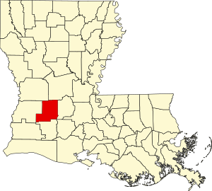
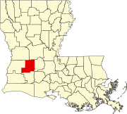
Beauregard Parish is a parish located in the U.S. state of Louisiana. As of the 2020 census, the population was 36,549. The parish seat is DeRidder. The parish was formed on January 1, 1913.

<span class="mw-page-title-main">Acadia Parish, Louisiana</span> Parish in Louisiana, United States

Acadia Parish is a parish located in the U.S. state of Louisiana. At the 2020 U.S. census, the population was 57,576. The parish seat is Crowley. The parish was founded from parts of St. Landry Parish in 1886, and later an election was held to determine the parish seat, ending when Crowley beat Rayne and Prairie Hayes. Acadia Parish is included in the Lafayette metropolitan statistical area.

<span class="mw-page-title-main">Kinder, Louisiana</span> Town in Louisiana, United States

Kinder is a small town in Allen Parish, Louisiana, in the United States. The population was 2,477 at the 2010 census.

<span class="mw-page-title-main">Oakdale, Louisiana</span> City in Louisiana, United States

Oakdale is a city in Allen Parish in south Louisiana, United States. The population was 7,780 at the 2010 census.

<span class="mw-page-title-main">Lake Charles, Louisiana</span> City in Louisiana, United States

Lake Charles is the fifth-most populous city in the U.S. state of Louisiana, and the parish seat of Calcasieu Parish, located on Lake Charles, Prien Lake, and the Calcasieu River. Founded in 1861 in Calcasieu Parish, it is a major industrial, cultural, and educational center in the southwest region of the state. As of the 2020 U.S. census, Lake Charles's population was 84,872.

<span class="mw-page-title-main">Elton, Louisiana</span> Town in Louisiana, United States

Elton is a town in Jefferson Davis Parish, Louisiana, United States. The population was 992 at the 2020 census, down from 1,128 at the 2010 census. It is part of the Jennings Micropolitan Statistical Area.

<span class="mw-page-title-main">Louisiana Highway 26</span> State highway in Louisiana, United States

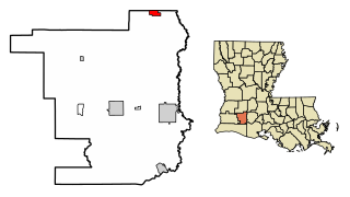
Louisiana Highway 26 (LA 26) is a state highway located in southwestern Louisiana. It runs 75.86 miles (122.08 km) in a northwest to southeast direction from a junction with the concurrent U.S. Highways 171 and 190 southeast of DeRidder to LA 14 in Lake Arthur.

Allen Parish School Board is a school district headquartered in Oberlin in Allen Parish in southwestern Louisiana, United States.

References

  1. "Census - Geography Profile: Allen Parish, Louisiana". United States Census Bureau . Retrieved January 21, 2023.
  2. "Find a County". National Association of Counties. Archived from the original on May 31, 2011. Retrieved June 7, 2011.
  3. "2010 Census Gazetteer Files". United States Census Bureau. August 22, 2012. Archived from the original on September 28, 2013. Retrieved August 20, 2014.
  4. Stoeser, Douglas B.; et al. (2005). "Geology of Louisiana, USA". Data Basin. Retrieved March 9, 2024.
  5. Daigle, Jerry J.; Griffith, Glenn E.; Omernik, James M.; Faulkner, Patricia L.; McCulloh, Richard P.; Handley, Lawrence R.; Smith, Latimore M.; Chapman, Shannen S. (2006). "Ecoregions of Louisiana" (PDF). United States Geological Survey . Archived (PDF) from the original on September 30, 2023. Retrieved March 8, 2024.
  6. "U.S. Decennial Census". United States Census Bureau. Retrieved August 20, 2014.
  7. "Historical Census Browser". University of Virginia Library. Retrieved August 20, 2014.
  8. "Population of Counties by Decennial Census: 1900 to 1990". United States Census Bureau. Retrieved August 20, 2014.
  9. "Census 2000 PHC-T-4. Ranking Tables for Counties: 1990 and 2000" (PDF). United States Census Bureau. Retrieved August 20, 2014.
  10. "State & County QuickFacts". United States Census Bureau. Archived from the original on June 7, 2011. Retrieved August 20, 2013.
  11. "Explore Census Data". data.census.gov. Retrieved December 29, 2021.
  12. "U.S. Census website". United States Census Bureau . Retrieved January 31, 2008.
  13. "Language Map Data Center". apps.mla.org.
  14. "U.S. Census Bureau QuickFacts: Allen Parish, Louisiana". United States Census Bureau . Retrieved March 9, 2024.
  15. U.S. Bureau of Economic Analysis (January 1, 2001). "Gross Domestic Product: All Industries in Allen Parish, LA". FRED, Federal Reserve Bank of St. Louis. Retrieved March 9, 2024.
  16. "Allen Parish". LSU AgCenter. July 31, 2023. Retrieved March 9, 2024.
  17. "About Coushatta Casino Resort". Coushatta Casino Resort. Retrieved March 9, 2024.
  18. 1 2 "Economic Development". Kinder Chamber of Commerce. Retrieved March 9, 2024.
  19. "Coushatta Powwow". Coushatta Powwow. Retrieved March 9, 2024.
  20. "Allen Parish Cultural Center". Allen Parish. Retrieved March 9, 2024.
  21. Sumrall, Bill (September 27, 2008). "A step into past: Museum showcases history of Allen Parish". The Town Talk.[ dead link ]
  22. Leip, David. "Dave Leip's Atlas of U.S. Presidential Elections". uselectionatlas.org. Retrieved March 9, 2018.
  23. Board, Allen Parish School. "Allen Parish School Board - Home". www.allen.k12.la.us.
  24. "Our Colleges". Louisiana's Technical and Community Colleges . Retrieved June 3, 2021.
  25. "Oakdale Journal". Louisiana Press Association. February 18, 2020. Retrieved March 9, 2024.
  26. "The Kinder Courier News". Louisiana Press Association. February 20, 2020. Retrieved March 9, 2024.
  27. "Radio Member Directory". Louisiana Association of Broadcasters. June 1, 2020. Retrieved March 9, 2024.
  28. "Radio Stations in Oakdale, Louisiana". radio-locator.com. Retrieved March 9, 2024.
  29. "Oakdale TV Channels - 71463 TV Antenna". Channel Master. Retrieved March 9, 2024.
  30. "Kinder TV Channels - 70648 TV Antenna". Channel Master. Retrieved March 9, 2024.
  31. "Oberlin TV Channels - 70655 TV Antenna". Channel Master. Retrieved March 9, 2024.

Geology