Climate change in Louisiana

Last updated
Koppen climate types in Louisiana show that the entire state is humid subtropical. Louisiana Koppen.png
Köppen climate types in Louisiana show that the entire state is humid subtropical.

Climate change in Louisiana encompasses the effects of climate change, attributed to man-made increases in atmospheric carbon dioxide, in the U.S. state of Louisiana.

Contents

Studies show that Louisiana is among a string of "Deep South" states that will experience the worst effects of climate change. [1] According to the United States Environmental Protection Agency (EPA), "[i]n the coming decades, Louisiana will become warmer, and both floods and droughts may become more severe. Unlike most of the nation, Louisiana did not become warmer during the last century. But soils have become drier, annual rainfall has increased, more rain arrives in heavy downpours, and sea level is rising. The changing climate is likely to increase damages from floods, reduce crop yields and harm fisheries, increase the number of unpleasantly hot days, and increase the risk of heat stroke and other heat-related illnesses". [2]

Louisiana is expected to be the site of substantial climate refugee challenge, because of the loss of coastline, changing environmental conditions that make the humid coastal ecosystems not easily habitable, and declining economic viability of industries in that geography. [3]

In 2021, Louisiana experienced a substantial impact from Hurricane Ida, which was noted as having characteristics that are probably more common in a warmer climate: the intensity, the rapid intensification, and the amount of rainfall over land. [4]

Rising seas and retreating shores

Land loss in coastal Louisiana 1932 vs 2011 Land loss in coastal Louisiana since 1932 NOAA2013.jpg
Land loss in coastal Louisiana 1932 vs 2011
Population density and low elevation coastal zones in Louisiana New Orleans, Louisiana, United States of America Population Density and Low Elevation Coastal Zones (5457913950).jpg
Population density and low elevation coastal zones in Louisiana
Aftermath of Hurricane Laura, Lake Charles HurricaneLauraAftermathLA-13.jpg
Aftermath of Hurricane Laura, Lake Charles

According to the EPA: "Rising sea level is likely to accelerate coastal erosion caused today by sinking land and human activities. The sediment washing down the Mississippi River created the river delta that comprises most of coastal Louisiana. These sediments gradually compact, so the land sinks about one inch every three years. Historically, the river would occasionally overflow its banks and deposit enough new sediment to allow the land surface to keep pace with rising sea level and the delta’s tendency to sink. But today, river levees, navigation channels, and other human activities thwart this natural land-building process, so coastal lands are being submerged. Louisiana has been losing about 25 square miles of land per year in recent decades". [2]

The EPA further reports: "If temperatures continue to warm, sea level is likely to rise one to three feet during the next century. Rising sea level has the same effect as sinking land, so changing climate is likely to accelerate coastal erosion and land loss. Federal, state, and local governments have ongoing projects to slow land loss in Louisiana, but if the sea rises more rapidly in the future, these efforts will become increasingly difficult". [2]

Tropical storms

President Donald Trump viewing Hurricane Laura damage, Lake Charles President Trump in Louisiana (50290475166).jpg
President Donald Trump viewing Hurricane Laura damage, Lake Charles

According to the EPA, "tropical storms and hurricanes have become more intense during the past 20 years. Although warming oceans provide these storms with more potential energy, scientists are not sure whether the recent intensification reflects a long-term trend. Nevertheless, hurricane wind speeds and rainfall rates are likely to increase as the climate continues to warm". [2] According to the Fifth National Climate Assessment published in 2023, coastal states including California, Florida, Louisiana, and Texas are experiencing "more significant storms and extreme swings in precipitation". [5]

Climate change impacts on tropical storms, have already increased damage to cities like New Orleans, causing climate migration. For example, New Orleans has 60,000 fewer people than it did before Hurricane Katrina. [3]

Increased flooding

Walgreens destroyed in Hurricane Ida, Larose, 2021 Alabama National Guard protects damaged Walgreens from Hurricane Ida survivors, Larose, Louisiana 02.jpg
Walgreens destroyed in Hurricane Ida, Larose, 2021

"Whether or not tropical storms become more frequent, rising sea level makes low-lying areas more prone to flooding. Many coastal roads, railways, airports, and oil and gas facilities are vulnerable to the impacts of storms and sea level rise. Louisiana is especially vulnerable, because much of New Orleans and other populated areas are below sea level, protected by levees and pumping systems that remove rainwater, which cannot drain naturally. With a higher sea level, these levees may be overtopped more readily during storms.

Solar roof, City Park, New Orleans, 2021 City Park, New Orleans, 5 October 2021 - 46.jpg
Solar roof, City Park, New Orleans, 2021

Severe flooding can disrupt the economy of a city by inducing people to move away, which occurred after Hurricane Katrina in New Orleans. The greater flood risk is also likely to increase flood insurance rates". [2]

Flooding, Holly Beach FEMA - 16666 - Photograph by Win Henderson taken on 10-03-2005 in Louisiana.jpg
Flooding, Holly Beach

The EPA notes that "changing climate is also likely to increase the risk of inland flooding. Since 1958, the amount of precipitation falling during heavy rainstorms has increased by 27 percent in the Southeast, and the trend toward increasingly heavy rainstorms is likely to continue. Moreover, the amount of rainfall in the Midwest is also likely to increase, which could worsen flooding in Louisiana, because most of the Midwest drains into the Mississippi River". [2]

The EPA further reports that "the Port of New Orleans is vulnerable to river floods that shut down traffic on the Mississippi River, as well as coastal storms that can flood port facilities. In 2011, high water levels on the Mississippi River led the U.S. Army Corps of Engineers to divert water through the Morganza Spillway to the Atchafalaya River to prevent serious flooding of Baton Rouge and New Orleans. The resulting high water on the Atchafalaya flooded small towns and about 1,000 square miles of agricultural land, and required temporary levees to protect Morgan City. Although major flooding on the Mississippi River was avoided, high water levels still caused a barge collision that led the Corps to close the river near Baton Rouge for four days". [2]

Agriculture, forests, and fisheries

A heat stroke victim is treated during the 2016 Louisiana floods Heat stroke treatment, Baton Rouge, 2016 Louisiana floods.jpg
A heat stroke victim is treated during the 2016 Louisiana floods
Wildfire, Lacassine NWR, 2014 Goose Fire - Lacassine NWR (13151078275).jpg
Wildfire, Lacassine NWR, 2014

According to the EPA, "changing climate will have both harmful and beneficial effects on farming. Seventy years from now, Louisiana is likely to have 35 to 70 days with temperatures above 95°F, compared with about 15 days today. Even during the next few decades, hotter summers are likely to reduce yields of corn and rice. But higher concentrations of atmospheric carbon dioxide increase crop yields, and that fertilizing effect is likely to offset the harmful effects of heat on soybeans and cotton—if adequate water is available. On farms without irrigation, however, increasingly severe droughts could cause more crop failures.

Higher temperatures are also likely to reduce livestock productivity, because heat stress disrupts the animals’ metabolism. Higher temperatures and changes in rainfall are unlikely to substantially reduce forest cover in Louisiana, although the composition of trees in the forests may change. More droughts would reduce forest productivity, and climate change is also likely to increase the damage from insects and disease. But longer growing seasons and increased concentrations of carbon dioxide could more than offset the losses from those factors. Forests cover about half of the state, with loblolly-shortleaf pine forests most common outside of wetland areas. Changing climate may cause the loblolly and shortleaf pine trees to give way to oak-pine forests". [2]

The EPA further reports that "rising sea level and higher temperatures threaten Louisiana's fisheries. Coastal wetlands account for most of the land that the state has been losing. Those wetlands support shrimp, oyster, crab, crawfish, menhaden, and other fisheries–about 75 percent of the state’s total commercial fisheries". [2]

Oysters and shrimp are sensitive to severe weather conditions due to their requirements for water temperature and water salinity. [6] The changes in shrimp distribution have directly impacted the Vietnamese shrimping community. [7]

The EPA also notes that "rising temperatures may also harm fish by reducing levels of dissolved oxygen in the water, promoting harmful algal blooms, bacteria, and other factors that contribute to diseases in coastal waters". [2]

See also

Related Research Articles

<span class="mw-page-title-main">Gulf Coast of the United States</span> Coastline in the United States

The Gulf Coast of the United States, also known as the Gulf South or the South Coast, is the coastline along the Southern United States where they meet the Gulf of Mexico. The coastal states that have a shoreline on the Gulf of Mexico are Texas, Louisiana, Mississippi, Alabama, and Florida, and these are known as the Gulf States.

<span class="mw-page-title-main">Hurricane preparedness in New Orleans</span>

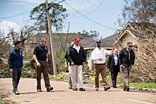
Hurricane preparedness in New Orleans has been an issue since the city's early settlement because of its location.

Drainage in New Orleans, Louisiana, has been a major concern since the founding of the city in the early 18th century, remaining an important factor in the history of New Orleans today. The central portion of metropolitan New Orleans is fairly unusual in that it is almost completely surrounded by water: Lake Pontchartrain to the north, Lake Borgne to the east, wetlands to the east and west, and the Mississippi River to the south. Half of the land area between these bodies of water is at or below sea level, and no longer has a natural outlet for flowing surface water. As such, virtually all rainfall occurring within this area must be removed through either evapotranspiration or pumping. Thus, flood threats to metropolitan New Orleans include the Mississippi River, Lake Pontchartrain, canals throughout the city, and natural rainfall. Artificial levees have been built to keep out rising river and lake waters but have had the negative effect of keeping rainfall in, and have failed on numerous occasions.

<span class="mw-page-title-main">Effects of Hurricane Isaac in Louisiana</span> Effects of Hurricane Isaac in 2012

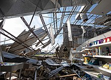
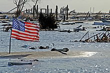
The effects of Hurricane Isaac in Louisiana were more severe than anywhere in the storm's path, and included $611.8615 million in damages and five total deaths. Forming from a tropical wave in the central Atlantic, Isaac traversed across many of the Lesser and Greater Antilles, before reaching peak intensity with winds of 80 mph (130 km/h) on August 28, 2012 while in the Gulf of Mexico. Nearing the coast of Louisiana, the Category 1 hurricane slowly moved towards the west, making two landfalls in the state with little change of intensity prior to moving inland for a final time. The hurricane weakened and later dissipated on September 1 while over Missouri. Before landfall, Governor Bobby Jindal declared a state of emergency to the state, as well as ordering the mandatory evacuation of 60,000 residents in low-lying areas of Louisiana along the Tangipahoa River in Tangipahoa Parish.

<span class="mw-page-title-main">Coastal erosion in Louisiana</span> Overview of costal erosion in Louisiana

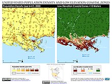
Coastal erosion in Louisiana is the process of steady depletion of wetlands along the state's coastline in marshes, swamps, and barrier islands, particularly affecting the alluvial basin surrounding the mouth of the Mississippi River. In the last century, Southeast Louisiana has lost a large portion of its wetlands and is expected to lose more in the coming years, with some estimates claiming wetland losses equivalent to up to one football field per hour. One consequence of coastal erosion is an increased vulnerability to hurricane storm surges, which affects the New Orleans metropolitan area and other communities in the region. The state has outlined a comprehensive master plan for coastal restoration and has begun to implement various restoration projects such as fresh water diversions, but certain zones will have to be prioritized and targeted for restoration efforts, as it is unlikely that all depleted wetlands can be rehabilitated.

<span class="mw-page-title-main">Climate change in Alabama</span> Climate change in the US state of Alabama

Climate change in Alabama encompasses the effects of climate change, attributed to man-made increases in atmospheric carbon dioxide, in the U.S. state of Alabama.

<span class="mw-page-title-main">Climate change in Arkansas</span> Climate change in the US state of Arkansas

In contrast to other parts of the United States, Arkansas has not seen a significant increase in temperature over the last 50–100 years. In fact, some parts of the state have cooled. However, the state does receive more annual rainfall and more frequent downpours than other states. Over the next few decades, Arkansas is expected to warm, experiencing an increased severity of flooding and droughts. It is also expected to suffer more storm damage, reduced agricultural yields, and harm to livestock. Arkansas might also have to contend with a heightened risk of heat-related illnesses. In addition, there has been an increase in the number of tornadoes observed in the central United States, including Arkansas.

<span class="mw-page-title-main">Climate change in Connecticut</span> Climate change in the US state of Connecticut

Climate change in Connecticut encompasses the effects of climate change, attributed to man-made increases in atmospheric carbon dioxide, in the U.S. state of Connecticut.

<span class="mw-page-title-main">Climate change in Delaware</span> Climate change in the US state of Delaware

Climate change in Delaware encompasses the effects of climate change, attributed to man-made increases in atmospheric carbon dioxide, in the U.S. state of Delaware.

<span class="mw-page-title-main">Climate change in Georgia (U.S. state)</span> Climate change in the US state of Georgia

Climate change in Georgia encompasses the effects of climate change, attributed to man-made increases in atmospheric carbon dioxide, in the U.S. state of Georgia.

Climate change in Guam encompasses the effects of climate change, attributed to man-made increases in atmospheric carbon dioxide, in the U.S. territory of Guam.

<span class="mw-page-title-main">Climate change in Minnesota</span> Climate change in the US state of Minnesota

Climate change in Minnesota encompasses the effects of climate change, attributed to human-caused increases in atmospheric carbon dioxide, in the U.S. state of Minnesota.

<span class="mw-page-title-main">Climate change in Mississippi</span> Climate change in the US state of Mississippi

Climate change in Mississippi encompasses the effects of climate change, attributed to man-made increases in atmospheric carbon dioxide, in the U.S. state of Mississippi.

<span class="mw-page-title-main">Climate change in the United States Virgin Islands</span> Impacts and responses of the US Virgin Islands related to climate change

Climate change in the United States Virgin Islands encompasses the effects of climate change, attributed to man-made increases in atmospheric carbon dioxide, in the U.S. territory of the United States Virgin Islands. The United States Environmental Protection Agency (EPA) has noted a variety of expected consequences of this phenomenon.

<span class="mw-page-title-main">Climate change in South Carolina</span> Climate change in the US state of South Carolina

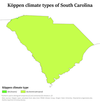
Climate change in South Carolina encompasses the effects of climate change, attributed to man-made increases in atmospheric carbon dioxide, in the U.S. state of South Carolina.

<span class="mw-page-title-main">Climate change in Tennessee</span> Climate change in the US state of Tennessee

Climate change in Tennessee encompasses the effects of climate change, attributed to man-made increases in atmospheric carbon dioxide, in the U.S. state of Tennessee.

<span class="mw-page-title-main">Climate change in Virginia</span> Climate change in the US state of Virginia

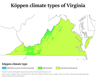
Climate change in Virginia encompasses the effects of climate change, attributed to man-made increases in atmospheric carbon dioxide, in the U.S. state of Virginia.

<span class="mw-page-title-main">Climate change in New Jersey</span> Climate change in the US state of New Jersey

Climate change in New Jersey is of concern due to its effects on the ecosystem, economy, infrastructure, and people of the U.S. state of New Jersey. According to climatology research by the U.S. National Oceanic and Atmospheric Administration, New Jersey has been the fastest-warming state by average air temperature over a 100-year period beginning in the early 20th century, related to global warming.

<span class="mw-page-title-main">Climate change in Texas</span> Climate change in the US state of Texas

The climate in Texas is changing partially due to global warming and rising trends in greenhouse gas emissions. As of 2016, most area of Texas had already warmed by 1.5 °F (0.83 °C) since the previous century because of greenhouse gas emissions by the United States and other countries. Texas is expected to experience a wide range of environmental impacts from climate change in the United States, including rising sea levels, more frequent extreme weather events, and increasing pressure on water resources.

<span class="mw-page-title-main">Climate change in Pennsylvania</span> Climate change in the US state of Pennsylvania

Climate change in Pennsylvania encompasses the effects of climate change, attributed to man-made increases in atmospheric carbon dioxide, in the U.S. state of Pennsylvania.

References

  1. Meyer, Robinson (June 29, 2017). "The American South Will Bear the Worst of Climate Change's Costs". The Atlantic .
  2. 1 2 3 4 5 6 7 8 9 10 "What Climate Change Means for Louisiana" (PDF). United States Environmental Protection Agency. August 2016.
  3. 1 2 McDonnell, Tim. "Louisiana's population is already moving to escape climate catastrophe". Quartz. Retrieved 2020-09-18.
  4. Gibbens, Sarah (August 31, 2021). "How climate change is fueling hurricanes like Ida". National Geographic. Archived from the original on August 31, 2021. Retrieved September 1, 2021.
  5. Nilsen, Ella (November 14, 2023). "No place in the US is safe from the climate crisis, but a new report shows where it's most severe". CNN.
  6. Buchanan, Susan (18 February 2019). "Climate change hurts Louisiana's oysters and shrimp". Louisiana Weekly. Archived from the original on 2019-02-20. Retrieved 2019-11-13.
  7. Wist, Allie (2019-11-13). "How Louisiana's Vietnamese Shrimpers Are Adapting to Climate Change". Saveur. Archived from the original on 2019-11-13. Retrieved 2019-11-13.

Further reading