West Feliciana Parish is a civil parish located in the U.S. state of Louisiana. At the 2010 census, the population was 15,625, and 15,310 at the 2020 census. The parish seat is St. Francisville. The parish was established in 1824.

Vermilion Parish is a parish located in the U.S. state of Louisiana, created in 1844. The parish seat is Abbeville. Vermilion Parish is part of the Lafayette metropolitan statistical area, and located in southern Acadiana. At the 2010 U.S. census, the population was 57,999; the 2019 American Community Survey estimated its population was 59,865.
Richland Parish is a parish located in the North Louisiana Delta Country in the U.S. state of Louisiana, known for its fertile, flat farmland, cane brakes, and open spaces. The name Richland was chosen due to the rich production from farming. The parish seat and largest community is Rayville.

East Feliciana Parish is a parish located in the U.S. state of Louisiana. At the 2010 census, the population was 20,267, and 19,531 in 2020. The parish seat is Clinton.

East Baton Rouge Parish is the most populous parish in the U.S. state of Louisiana. At the 2010 U.S. census, its population was 440,171, and 456,781 at the 2020 census. The parish seat is Baton Rouge, Louisiana's state capital. East Baton Rouge Parish is located within the Greater Baton Rouge area.

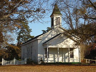
Jackson is a town in East Feliciana Parish, Louisiana, United States. The population was 3,842 at the 2010 U.S. census, down from 4,130 in 2000; the 2020 population estimates program determined Jackson had a population of 3,707. It is part of the Baton Rouge metropolitan statistical area.

Harvey is a census-designated place (CDP) in Jefferson Parish, Louisiana, United States. Harvey is on the south side of the Mississippi River, within the New Orleans–Metairie–Kenner metropolitan statistical area. The majority-minority population was 20,348 at the 2010 census, down from 22,226 at the 2000 census. The 2020 census determined 22,236 people lived in the CDP.

Jefferson is a census-designated place (CDP) in Jefferson Parish, Louisiana, United States, on the north side of the Mississippi River. Jefferson is part of the New Orleans–Metairie–Kenner metropolitan statistical area. The population was 11,193 at the 2010 census, and 10,533 in 2020. It is often known by locals as "Old Jefferson", but should not be confused with Old Jefferson in East Baton Rouge Parish, Louisiana.
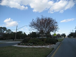
River Ridge is an unincorporated community and census-designated place (CDP) in Jefferson Parish, Louisiana, United States. It is a suburb of New Orleans. The population was 13,591 in 2020.
Terrytown is an unincorporated community and census-designated place (CDP) in Jefferson Parish, Louisiana, United States. It is on the "Westbank" of the Mississippi River. It is a suburb within the New Orleans–Metairie–Kenner metropolitan statistical area. The population was 23,319 at the 2010 census, and 25,278 in 2020.
Waggaman is a census-designated place and unincorporated community in Jefferson Parish, Louisiana, United States. Waggaman is on the West Bank of the Mississippi River, within the New Orleans–Metairie–Kenner metropolitan statistical area. The population was 9,835 at the 2020 census. The area was named for U.S. Senator George Augustus Waggaman (1782–1843).

Westwego is a city in the U.S. state of Louisiana, located in Jefferson Parish. It is a suburban community of New Orleans in the Greater New Orleans metropolitan area and lies along the west bank of the Mississippi River. The population of the city of Westwego was 8,568 at the 2020 United States census.

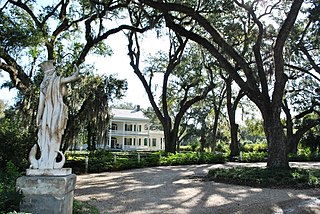
St. Francisville is a town in and the parish seat of, West Feliciana Parish, Louisiana, United States. The population was 1,765 at the 2010 U.S. census, and 1,589 at the 2020 population estimates program. It is part of the Baton Rouge metropolitan statistical area.
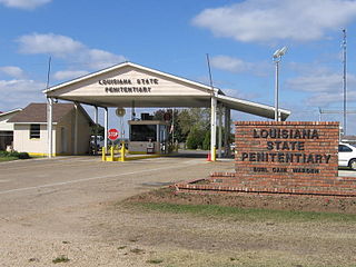
The Louisiana State Penitentiary is a maximum-security prison farm in Louisiana operated by the Louisiana Department of Public Safety & Corrections. It is named "Angola" after the former slave plantation that occupied this territory. The plantation was named after the country of Angola from which many slaves originated before arriving in Louisiana.
Wakefield is an unincorporated community in West Feliciana Parish, Louisiana, United States. Its elevation is 246 feet.
East Feliciana Public Schools is a school district headquartered in Clinton, Louisiana, United States. The district serves students in East Feliciana Parish.

West Feliciana Parish Public Schools (WFPPS) or West Feliciana Parish School Board (WFPSB) is a school district headquartered in St. Francisville, Louisiana, United States.
Baton Rouge offers a wide range of educational and cultural opportunities including being the home to three major universities and colleges and a variety of public and private schools.

Louisiana Highway 66 (LA 66) is a state highway located in southeastern Louisiana. It runs 19.62 miles (31.58 km) in a general east–west direction from the main entrance of the Louisiana State Penitentiary at Angola to a junction with U.S. Highway 61 (US 61) north of St. Francisville.
Tunica is an unincorporated community in West Feliciana Parish, Louisiana, United States. Its elevation is 66 feet.


