Benton County | |
---|---|
Coordinates: 44°29′25″N123°25′57″W / 44.490277777778°N 123.4325°W | |
Country | United States |
State | Oregon |
Founded | December 23, 1847 |
Named for | Thomas H. Benton |
Seat | Corvallis |
Largest city | Corvallis |
Area | |
• Total | 679 sq mi (1,760 km2) |
• Land | 676 sq mi (1,750 km2) |
• Water | 2.7 sq mi (7 km2) 0.4% |
Population (2020) | |
• Total | 95,184 |
• Estimate (2023) | 97,713 |
• Density | 127/sq mi (49/km2) |
Time zone | UTC−8 (Pacific) |
• Summer (DST) | UTC−7 (PDT) |
Congressional district | 4th |
Website | www |
Benton County is one of the 36 counties in the U.S. state of Oregon. As of the 2020 census, the population was 95,184. [1] Its county seat is Corvallis. [2] The county was named after Thomas Hart Benton, a U.S. Senator who advocated American control over the Oregon Country. Benton County is designated as the Corvallis, OR Metropolitan Statistical Area, which is included in the Portland–Vancouver–Salem, OR–WA Combined Statistical Area. It is in the Willamette Valley.
Benton County was created on December 23, 1847, by an act of the Provisional Government of Oregon. [3] The county was named after Democratic Senator Thomas Hart Benton of Missouri, an advocate of the doctrine of Manifest Destiny and the belief that the American government should control the whole of the Oregon Country. At the time of its formation the county included all the country west of the Willamette River, south of Polk County and running all the way to the California border in the south and the Pacific Ocean in the west. [4]
The county was created out of lands originally inhabited by the Klickitat, who rented it from the Kalapuyas for use as hunting grounds. All aboriginal claims to land within Benton County were ceded in the Treaty of Dayton in 1855. Portions of Benton County were taken to form Coos, Curry, Douglas, Jackson, Josephine, Lane and Lincoln Counties, leaving Benton County in its present form.
The city of Marysville, later renamed Corvallis, was made the county seat in 1851. The city briefly was the capital of Oregon. [5] In 1862 Corvallis became the site of the Oregon State Agricultural College, known today as Oregon State University.
According to the United States Census Bureau, the county has a total area of 679 square miles (1,760 km2), of which 676 square miles (1,750 km2) is land and 2.7 square miles (7.0 km2) (0.4%) is water. [6] It is the fourth-smallest county in Oregon by land area and third-smallest by total area.
Census | Pop. | Note | %± |
---|---|---|---|
1850 | 814 | — | |
1860 | 3,074 | 277.6% | |
1870 | 4,584 | 49.1% | |
1880 | 6,403 | 39.7% | |
1890 | 8,650 | 35.1% | |
1900 | 6,706 | −22.5% | |
1910 | 10,663 | 59.0% | |
1920 | 13,744 | 28.9% | |
1930 | 16,555 | 20.5% | |
1940 | 18,629 | 12.5% | |
1950 | 31,570 | 69.5% | |
1960 | 39,165 | 24.1% | |
1970 | 53,776 | 37.3% | |
1980 | 68,211 | 26.8% | |
1990 | 70,811 | 3.8% | |
2000 | 78,153 | 10.4% | |
2010 | 85,579 | 9.5% | |
2020 | 95,184 | 11.2% | |
2023 (est.) | 97,713 | [7] | 2.7% |
U.S. Decennial Census [8] 1790–1960 [9] 1900–1990 [10] 1990–2000 [11] 2010–2020 [1] |
As of the 2020 census, there were 95,184 people, the racial make up of the county was 75.9% non-Hispanic white, 1% African American, 0.6% Native American, 6.7% Asian, 6.1% of two or more races. Residents of Hispanic or Latino ancestry made up 9% of the population.
As of the 2010 census, there were 85,579 people, 34,317 households, and 19,256 families residing in the county. [12] The population density was 126.6 inhabitants per square mile (48.9 inhabitants/km2). There were 36,245 housing units at an average density of 53.6 units per square mile (20.7 units/km2). [13] The racial makeup of the county was 87.1% white, 5.2% Asian, 0.9% black or African American, 0.7% American Indian, 0.2% Pacific islander, 2.3% from other races, and 3.6% from two or more races. Those of Hispanic or Latino origin made up 6.4% of the population. [12] In terms of ethnicity, 22.6% reported German ancestry, 16.1% English, 13.5% Irish, and 3.6% were American heritage. [14]
Of the 34,317 households, 24.2% had children under the age of 18 living with them, 45.3% were married couples living together, 7.3% had a female householder with no husband present, 43.9% were non-families, and 28.2% of all households were made up of individuals. The average household size was 2.35 and the average family size was 2.87. The median age was 32.1 years. [12]
The median income for a household in the county was $48,012 and the median income for a family was $71,763. Males had a median income of $50,282 versus $35,387 for females. The per capita income for the county was $26,177. About 7.7% of families and 19.1% of the population were below the poverty line, including 13.6% of those under age 18 and 5.5% of those age 65 or over. [15]
As of the 2000 census, there were 78,153 people, 30,145 households, and 18,237 families residing in the county. The population density was 116 people per square mile (45 people/km2). There were 31,980 housing units at an average density of 47 units per square mile (18/km2). The racial makeup of the county was 89.16% White, 0.84% Black or African American, 0.79% Native American, 4.49% Asian, 0.24% Pacific Islander, 1.92% from other races, and 2.56% from two or more races. 4.66% of the population were Hispanic or Latino of any race. 18.2% were of German, 11.6% English, 8.9% Irish and 7.0% American ancestry. 91.1% spoke English, 4.1% Spanish and 1.0% Chinese as their first language.
There were 30,145 households, out of which 28.40% had children under the age of 18 living with them, 50.40% were married couples living together, 7.20% had a female householder with no husband present, and 39.50% were non-families. 26.10% of all households were made up of individuals, and 6.70% had someone living alone who was 65 years of age or older. The average household size was 2.43 and the average family size was 2.95.
In the county, 21.30% of the population was under the age of 18, 20.20% was from 18 to 24, 26.70% from 25 to 44, 21.40% from 45 to 64, and 10.30% was 65 years of age or older. The median age was 31 years. For every 100 females there were 99.10 males. For every 100 females age 18 and over, there were 97.80 males.
The median income for a household in the county was $41,897, and the median income for a family was $56,319. Males had a median income of $42,018 versus $29,795 for females. The per capita income for the county was $21,868. About 6.80% of families and 14.60% of the population were below the poverty line, including 10.60% of those under age 18 and 4.90% of those age 65 or over.
Benton County has the lowest church attendance per capita of any county in the nation (25% attendance). [16]
For a long time, Benton County strongly favored the Republican Party due to its significant Yankee influence. In the 1932 presidential election, it was the only county in the state to vote for Herbert Hoover instead of FDR. Along with Riverside County in California, it was one of only two counties in the Pacific States to be held by Hoover that year. As late as 1960, [17] Benton was the most Republican county in the traditionally Republican state of Oregon, which at that point had never supported a Democrat other than FDR for president, except for 1912 when the Republican Party was divided and a very narrow victory in 1868. Up to 1984, Benton County had voted for a Democratic presidential candidate only four times, in the above-mentioned 1868 election plus the national Democratic landslides of 1912, 1936, and 1964. In 1964, Lyndon Johnson became the first Democrat to win an absolute majority of the county's vote since Horatio Seymour. [18]
The Republican edge in the county narrowed from the 1970s onward, culminating when it swung from a five-point victory for Ronald Reagan in 1984 to a nine-point victory for Michael Dukakis in 1988. Since then, Benton County has become a strongly Democratic county, and is usually the second-strongest Democratic bastion in the state, behind only Multnomah County (Portland). This is largely due to the leanings of Oregon State's student body and staff, closely tracking with Democratic gains in other counties influenced by college towns. No Republican has come within nine percentage points of carrying Benton County since 1988, and Barack Obama, Hillary Clinton, and Joe Biden have won the county by over thirty percentage points during each of the last four presidential elections. Overall, Benton County is a reliable state bellwether, having voted for Oregon's statewide winner in every presidential election since 1948, along with Hood River County.
Since 1972, Benton County has been a home rule county, meaning that the citizens have full control over the county charter, rather than using a standard charter issued by the state. [19] The voters have chosen to eliminate the traditional elected county offices of Assessor, Treasurer, Surveyor, Justice of the Peace, and Clerk. Currently, they only elect three County Commissioners and a Sheriff. [20] [21]
The three current Benton County Commissioners are Chair Pat Malone, Xanthippe Augerot, and Nancy Wyse. They are all members of the Democratic Party and have served since 2019, 2017, and 2021; respectively. Wyse and Augerot's current terms expire in January 2025, while Malone's is up in January 2023. [21] [22] [23]
The current Benton County Sheriff is Jef Van Arsdall. He was appointed to the office in March 2021 to fill the remainder of the term of retiring sheriff Scott Jackson. [24]
Benton County is currently one of 11 counties in Oregon in which therapeutic psilocybin is legal.
Year | Republican | Democratic | Third party | |||
---|---|---|---|---|---|---|
No. | % | No. | % | No. | % | |
2020 | 14,878 | 28.18% | 35,827 | 67.86% | 2,094 | 3.97% |
2016 | 13,445 | 27.58% | 29,193 | 59.88% | 6,115 | 12.54% |
2012 | 14,991 | 33.46% | 27,776 | 62.00% | 2,035 | 4.54% |
2008 | 15,264 | 32.84% | 29,901 | 64.33% | 1,313 | 2.82% |
2004 | 18,460 | 40.36% | 26,515 | 57.98% | 760 | 1.66% |
2000 | 15,825 | 41.40% | 19,444 | 50.87% | 2,957 | 7.74% |
1996 | 12,450 | 36.09% | 17,211 | 49.89% | 4,839 | 14.03% |
1992 | 11,550 | 30.46% | 17,966 | 47.37% | 8,407 | 22.17% |
1988 | 14,004 | 44.30% | 16,930 | 53.56% | 676 | 2.14% |
1984 | 17,836 | 52.36% | 16,073 | 47.19% | 153 | 0.45% |
1980 | 14,982 | 43.42% | 13,150 | 38.11% | 6,375 | 18.47% |
1976 | 15,555 | 53.08% | 11,887 | 40.56% | 1,865 | 6.36% |
1972 | 14,906 | 56.34% | 10,842 | 40.98% | 708 | 2.68% |
1968 | 11,654 | 61.29% | 6,538 | 34.38% | 824 | 4.33% |
1964 | 7,250 | 43.98% | 8,971 | 54.42% | 265 | 1.61% |
1960 | 9,734 | 64.36% | 5,391 | 35.64% | 0 | 0.00% |
1956 | 9,016 | 68.15% | 4,214 | 31.85% | 0 | 0.00% |
1952 | 9,229 | 75.27% | 2,966 | 24.19% | 67 | 0.55% |
1948 | 6,839 | 66.21% | 3,135 | 30.35% | 355 | 3.44% |
1944 | 5,242 | 64.39% | 2,830 | 34.76% | 69 | 0.85% |
1940 | 5,089 | 62.99% | 2,942 | 36.42% | 48 | 0.59% |
1936 | 3,390 | 45.67% | 3,547 | 47.78% | 486 | 6.55% |
1932 | 4,068 | 54.73% | 3,121 | 41.99% | 244 | 3.28% |
1928 | 4,605 | 75.55% | 1,412 | 23.17% | 78 | 1.28% |
1924 | 3,417 | 60.68% | 1,579 | 28.04% | 635 | 11.28% |
1920 | 3,752 | 66.25% | 1,719 | 30.35% | 192 | 3.39% |
1916 | 2,902 | 50.72% | 2,488 | 43.48% | 332 | 5.80% |
1912 | 715 | 27.43% | 986 | 37.82% | 906 | 34.75% |
1908 | 1,183 | 55.99% | 773 | 36.58% | 157 | 7.43% |
1904 | 1,107 | 62.51% | 442 | 24.96% | 222 | 12.54% |
Along with Oregon State University, agriculture, lumber, wood products, and some printing technology research and development form the economic base of the county. A substantial portion of the nation's research in forestry, agriculture, engineering, education and the sciences takes place at OSU.
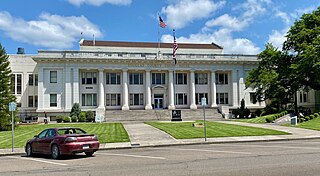
Washington County is one of 36 counties in the U.S. state of Oregon and part of the Portland metropolitan area. The 2020 census recorded the population as 600,372, making it the second most populous county in the state and most populous "Washington County" in the United States. Hillsboro is the county seat and largest city, while other major cities include Beaverton, Tigard, Cornelius, Banks, Gaston, Sherwood, North Plains, and Forest Grove, the county's oldest city. Originally named Twality when created in 1843, the Oregon Territorial Legislature renamed it for the nation's first president in 1849 and included the entire northwest corner of Oregon before new counties were created in 1854. The Tualatin River and its drainage basin lie almost entirely within the county, which shares its boundaries with the Tualatin Valley. It is bordered on the west and north by the Northern Oregon Coast Range, on the south by the Chehalem Mountains, and on the north and east by the Tualatin Mountains, or West Hills.
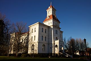
Corvallis is a city and the seat of government of Benton County in central western Oregon, United States. It is the principal city of the Corvallis, Oregon Metropolitan Statistical Area, which encompasses all of Benton County. As of the 2023 Census Population Estimates, the population was 61,087, making it the 9th most populous city in Oregon. Corvallis is the location of Oregon State University and Good Samaritan Regional Medical Center. Corvallis is the westernmost city in the contiguous 48 states with a population larger than 50,000.
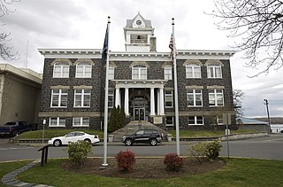
Wahkiakum County is a county located in the U.S. state of Washington. As of the 2020 census, the population was 4,422, making it one of the least populous counties in Washington. The county seat and only incorporated town is Cathlamet. The county was formed out of Cowlitz County in April 1854 and is named for Chief Wahkiakum of the Chinook, who is buried in the Pioneer Cemetery in Cathlamet.
Klickitat County is a county located in the U.S. state of Washington. As of the 2020 census, the population was 22,735. The county seat and largest city is Goldendale. The county is named after the Klickitat tribe.
Yamhill County is one of the 36 counties in the U.S. state of Oregon. As of the 2020 census, the population was 107,722. The county seat is McMinnville. Yamhill County was named after the Yamhelas, members of the Kalapuya Tribe.
Wheeler County is a county in the U.S. state of Oregon. As of the 2020 census, the population was 1,451, making it Oregon's least populous county. It is named in honor of Henry H. Wheeler. an early settler who owned a farm near Mitchell. The county seat is Fossil, and Wheeler County is known for having Oregon's largest deposit of fossils.
Wallowa County is the northeastern most county in the U.S. state of Oregon. As of the 2020 census, the population was 7,391, making it Oregon's fifth-least populous county. Its county seat is Enterprise. According to Oregon Geographic Names, the origins of the county's name are uncertain, with the most likely explanation being it is derived from the Nez Perce term for a structure of stakes used in fishing. An alternative explanation is that Wallowa is derived from a Nez Perce word for "winding water". The journals of Lewis and Clark Expedition record the name of the Wallowa River as Wil-le-wah.
Union County is one of the 36 counties in the U.S. state of Oregon, and one of the 8 counties of eastern Oregon. As of the 2020 census, the population was 26,196. The county comprises the La Grande micropolitan statistical area and the county seat is La Grande.
Polk County is one of the 36 counties in the U.S. state of Oregon. As of the 2020 census, the population was 87,433. The county seat is Dallas. The county is named for James Knox Polk, the 11th president of the United States.
Morrow County is one of the 36 counties in the U.S. state of Oregon. As of the 2020 census, the population was 12,186. The county seat is Heppner. The county is named for one of its first settlers, Jackson L. Morrow, who was a member of the state legislature when the county was created. Half of the Umatilla Chemical Depot, which includes the Umatilla Chemical Agent Disposal Facility, and the Naval Weapons Systems Training Facility Boardman are located within the county. Morrow County is part of the Pendleton-Hermiston, OR, Micropolitan Statistical Area. It is located on the south side of the Columbia River and is included in the eight-county definition of Eastern Oregon.
Malheur County is one of the 36 counties in the U.S. state of Oregon. As of the 2020 census, the population was 31,571. Its county seat is Vale, and its largest city is Ontario. The county was named after the Malheur River, which runs through the county. The word "malheur" is French for misfortune or tragedy. Malheur County is included in the Ontario, Oregon Micropolitan Statistical Area, which is also included in the Boise Combined Statistical Area. It is included in the eight-county definition of Eastern Oregon.
Linn County is one of the 36 counties in the U.S. state of Oregon. As of the 2023 census popluation estimates, the population was 131,496. The county seat is Albany. The county is named in the honor of Lewis F. Linn, a U.S. Senator from Missouri who advocated the American settlement of the Oregon Country. Linn County comprises the Albany, OR Metropolitan Statistical Area, which is included in the Portland-Vancouver-Salem, OR-WA Combined Statistical Area. It is located in the Willamette Valley. In 2010, the center of population of Oregon was located in Linn County, near the city of Lyons.
Lincoln County is one of the 36 counties in the U.S. state of Oregon. As of the 2020 census, its population was 50,395. The county seat is Newport. The county is named for Abraham Lincoln, 16th president of the United States.
Lane County is one of the 36 counties in the U.S. state of Oregon. As of the 2020 census, the population was 382,971, making it the fourth-most populous county in Oregon. The county seat is Eugene, the state's second most populous city. It is named in honor of Joseph Lane, Oregon's first territorial governor.
Jefferson County is one of the 36 counties in the U.S. state of Oregon. At the 2020 census, the population was 24,502. The county seat is Madras. The county is named after Mount Jefferson, the second tallest mountain in Oregon.
Douglas County is one of the 36 counties in the U.S. state of Oregon. As of the 2020 census, the population was 111,201. The county seat is Roseburg. The county is named after Stephen A. Douglas, an American politician who supported Oregon statehood. Douglas County comprises the Roseburg, OR Micropolitan Statistical Area. In regards to area, Douglas County is the largest county west of the Oregon Cascades.
Columbia County is one of the 36 counties in the U.S. state of Oregon. As of the 2020 census, the population was 52,589. The county seat is St. Helens.
Clatsop County is one of the 36 counties in the U.S. state of Oregon. As of the 2020 census, the population was 41,072. The county seat is Astoria. The county is named for the Clatsop tribe of Native Americans, who lived along the coast of the Pacific Ocean prior to European settlement. Clatsop County comprises the Astoria, OR Micropolitan Statistical Area, or Sunset Empire, and is located in Northwest Oregon.
Benton County is a county located in the west central part of the U.S. state of Missouri. The population was 19,394 as of the 2020 Census. Its county seat is Warsaw. The county was organized January 3, 1835, and named for U.S. Senator Thomas Hart Benton of Missouri.
Howard County is a county located in the US state of Iowa. As of the 2020 census, the population was 9,469. The county seat is Cresco. The county was founded in 1851; it was named for General Tilghman Ashurst Howard, a Representative of Indiana.