Union County, Oregon

Last updated

Union County
Union County Museum - Union Oregon.jpg
Union County Museum
Map of Oregon highlighting Union County.svg
Location within the U.S. state of Oregon
Oregon in United States.svg
Oregon's location within the U.S.
Coordinates: 45°19′38″N118°05′36″W / 45.327222222222°N 118.09333333333°W / 45.327222222222; -118.09333333333
CountryFlag of the United States.svg United States
StateFlag of Oregon.svg  Oregon
FoundedOctober 14, 1864
Named for Union, Oregon
Seat La Grande
Largest cityLa Grande
Area
  Total2,039 sq mi (5,280 km2)
  Land2,037 sq mi (5,280 km2)
  Water1.9 sq mi (5 km2)  0.1%
Population
 (2020)
  Total26,196
  Estimate 
(2023)
25,944 Decrease2.svg
  Density13/sq mi (5/km2)
Time zone UTC−8 (Pacific)
  Summer (DST) UTC−7 (PDT)
Congressional district 2nd
Website www.union-county.org

Union County is one of the 36 counties in the U.S. state of Oregon, and one of the 8 counties of eastern Oregon. As of the 2020 census, the population was 26,196. [1] The county comprises the La Grande micropolitan statistical area and the county seat is La Grande. [2]

Contents

History

According to Oregon Geographic Names , the county is named for the town of Union. Union County was originally part of Baker County (which was originally a part of Wasco County, which was originally part of Clackamas County). The northern end of the Grande Ronde Valley was the first part to be settled. [3] During the 1860s, population growth in eastern Oregon prompted the State Legislature to split Umatilla and Baker Counties from Wasco County in 1862. Further settlement in the Grande Ronde Valley led to the division of Baker County to create Union County on October 14, 1864. The county doubled in population between 1880 and 1890. [3]

The choice of a county seat resulted in competition, based on geography and on economic and population growth, between La Grande and the city of Union. The county seat alternated between Union and La Grande until it permanently came to rest at La Grande in 1905. Between 1875 and 1913, adjustments were made between Union County's borders and the borders of Baker, Umatilla, and Wallowa counties.

Geography

Union County UnionCountyMap.png
Union County

According to the United States Census Bureau, the county has a total area of 2,039 square miles (5,280 km2), of which 2,037 square miles (5,280 km2) is land and 1.9 square miles (4.9 km2) (0.1%) is water. [4] The Forest Service owns 47% of the land in the county.[ citation needed ]

Adjacent counties

Demographics

Historical population
CensusPop.Note
1870 2,552
1880 6,550156.7%
1890 12,04483.9%
1900 16,07033.4%
1910 16,1910.8%
1920 16,6362.7%
1930 17,4925.1%
1940 17,399−0.5%
1950 17,9623.2%
1960 18,1801.2%
1970 19,3776.6%
1980 23,92123.5%
1990 23,598−1.4%
2000 24,5303.9%
2010 25,7485.0%
2020 26,1961.7%
2023 (est.)25,944 [5] −1.0%
U.S. Decennial Census [6]
1790–1960 [7] 1900–1990 [8]
1990–2000 [9] 2010–2020 [1]

2010 census

As of the 2010 census, there were 25,748 people, 10,501 households, and 6,804 families living in the county. [10] The population density was 12.6 inhabitants per square mile (4.9/km2). There were 11,489 housing units at an average density of 5.6 units per square mile (2.2 units/km2). [11] The racial makeup of the county was 93.1% white, 1.1% American Indian, 0.9% Pacific islander, 0.8% Asian, 0.5% black or African American, 1.3% from other races, and 2.3% from two or more races. Those of Hispanic or Latino origin made up 3.9% of the population. [10] In terms of ancestry, 25.2% were German, 17.8% were Irish, 17.3% were English, and 6.9% were American. [12]

Of the 10,501 households, 28.2% had children under the age of 18 living with them, 51.3% were married couples living together, 9.5% had a female householder with no husband present, 35.2% were non-families, and 27.6% of all households were made up of individuals. The average household size was 2.38 and the average family size was 2.89. The median age was 40.0 years. [10]

The median income for a household in the county was $42,162 and the median income for a family was $52,558. Males had a median income of $40,720 versus $30,373 for females. The per capita income for the county was $22,947. About 10.5% of families and 16.1% of the population were below the poverty line, including 22.6% of those under age 18 and 10.2% of those age 65 or over. [13]

2000 census

As of the 2000 census, there were 24,530 people, 9,740 households, and 6,516 families living in the county. The population density was 12 people per square mile (4.6 people/km2). There were 10,603 housing units at an average density of 5 units per square mile (1.9/km2). The racial makeup of the county was 94.29% White, 0.85% Native American, 0.85% Asian, 0.62% Pacific Islander, 0.51% Black/African American, 1.22% from other races, and 1.67% from two or more races. Hispanics and Latinos of any race constitute 2.45% of the population. 20.2% were of German, 15.5% American, 12.2% English and 10.5% Irish ancestry.

There were 9,740 households, out of which 30.00% had children under the age of 18 living with them, 55.10% were married couples living together, 8.50% had a female householder with no husband present, and 33.10% were non-families. 26.10% of all households were made up of individuals, and 10.80% had someone living alone who was 65 years of age or older. The average household size was 2.45 and the average family size was 2.94.

In the county, the population was spread out, with 24.60% under the age of 18, 12.10% from 18 to 24, 23.50% from 25 to 44, 25.00% from 45 to 64, and 14.70% who were 65 years of age or older. The median age was 38 years. For every 100 females there were 95.10 males. For every 100 females age 18 and over, there were 92.40 males.

The median income for a household in the county was $33,738, and the median income for a family was $40,520. Males had a median income of $33,028 versus $21,740 for females. The per capita income for the county was $16,907. About 8.50% of families and 13.80% of the population were below the poverty line, including 13.60% of those under age 18 and 9.50% of those age 65 or over.

Communities

Cities

Unincorporated communities

Government and politics

Registered voters of 2009. Political orientations in Union County, Oregon (March 2009).gif
Registered voters of 2009.

Like the rest of eastern Oregon, the majority of registered voters who are part of a political party in Union County belong to the Republican Party. [14] In the 2016 presidential election, 65 percent of Union County voters voted for Republican Donald Trump, while 25 percent voted for Democrat Hillary Clinton and 10 percent of voters either voted for a Third Party candidate or wrote in a candidate. [15] These numbers show a large shift away from the Democratic party towards third-party candidates when compared to the 2012 presidential election, when 63.2% of Union Country voters voted for Mitt Romney, 32.9% voted for Barack Obama, and 3.8% of voters either voted for a third party candidate or wrote in a candidate. In 2020, however, the third party turnout dropped to 2.62% and Joe Biden won 28.47% of the vote, but the Republican lean remained with Trump winning over 68% of the vote.

United States presidential election results for Union County, Oregon [16]
Year Republican Democratic Third party
No.%No.%No.%
2020 10,29868.91%4,25428.47%3922.62%
2016 8,43165.01%3,24925.05%1,2889.93%
2012 7,63663.26%3,97332.92%4613.82%
2008 7,58160.20%4,61336.63%4003.18%
2004 8,87965.68%4,42832.75%2121.57%
2000 7,83664.89%3,57729.62%6635.49%
1996 5,41447.72%4,37938.60%1,55213.68%
1992 4,22336.44%3,99034.43%3,37529.12%
1988 5,06150.16%4,68246.40%3473.44%
1984 6,64561.36%4,13438.18%500.46%
1980 6,51457.79%3,67732.62%1,0819.59%
1976 5,11152.00%4,28043.54%4384.46%
1972 5,07356.46%3,27236.42%6407.12%
1968 3,79649.00%3,40944.00%5427.00%
1964 2,55334.09%4,92965.82%70.09%
1960 3,68947.48%4,08152.52%00.00%
1956 3,74946.07%4,38953.93%00.00%
1952 4,11453.69%3,52646.01%230.30%
1948 2,66839.83%3,80856.85%2223.31%
1944 2,41337.56%3,95161.50%600.93%
1940 2,64236.71%4,50062.53%540.75%
1936 1,51722.60%4,64369.17%5528.22%
1932 1,70526.85%4,45070.08%1953.07%
1928 3,21959.13%2,15439.57%711.30%
1924 2,42842.87%1,81632.07%1,41925.06%
1920 2,84456.65%1,89937.83%2775.52%
1916 2,25339.77%3,08654.47%3265.75%
1912 67121.41%1,09034.78%1,37343.81%
1908 1,51050.67%1,19139.97%2799.36%
1904 1,88462.88%77525.87%33711.25%

Oregon Legislative Assembly

Union County is located in Oregon State House District 58 which is currently represented by Bobby Levy. It is also located in Oregon State Senate District 29, represented by Bill Hansell. Both Levy and Hansell are registered Republicans. [17]

Board of Commissioners

Union County is represented and governed by three commissioners. The Union County Board of Commissioners is currently made up of Paul Anderes, Matt Scarfo, and Donna Beverage.[ needs update ] [18]

Economy

The initial economic interest in Union County was mining, but most of the mines in the area were annexed by Baker County in 1901.[ citation needed ] The local economy continues to be based on natural resources, including farming (wheat, fruit, vegetables, mint, and grass seed), ranching (cattle and sheep), and timber. The ridges of Pyles Canyon are the site of the Elkhorn Valley Wind Farm, owned and operated by Horizon Wind Energy and whose power is sold to Idaho Power. [19] Since October 2010, the county board of commissioners has supported a "strategic investment program" for another wind power project in Oregon, Horizon Wind Energy's proposed Antelope Ridge Wind Farm; [20] after delays due to concerns about the project's impact on wildlife, [21] the project has received support from Oregon Department of Fish and Wildlife. [22]

Nearby mountains and streams offer hunting, fishing, skiing, and camping, all of which attract vacationers. Attractions include the Anthony Lakes (and its ski area), Minam River, Mount Emily, Blue Mountains, Umatilla National Forest, Wallowa–Whitman National Forest (including Eagle Cap Wilderness), Catherine Creek State Park, Hilgard Junction State Recreation Area, Thief Valley Reservoir, Cove Hot Springs Pool, the Hot Lake Hotel (first built in the 1860s due to nearby hot springs), and the Eagle Cap Excursion Train.

Basalt outcroppings along the Grande Ronde River (August 2011). Grande Ronde River and Grande Ronde Basalt IMG 4536.jpg
Basalt outcroppings along the Grande Ronde River (August 2011).

Notes

    Related Research Articles

    <span class="mw-page-title-main">Garfield County, Washington</span> County in Washington, United States

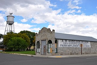
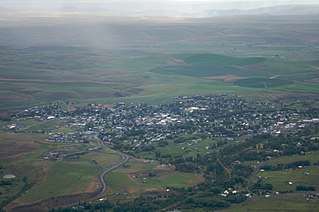
    Garfield County is a county located in the U.S. state of Washington. As of the 2020 census, the population was 2,286, making it the least populous county in Washington; with about 3.2 inhabitants per square mile (1.2/km2), it is also the least densely populated county in Washington. The county seat and only city is Pomeroy.

    <span class="mw-page-title-main">Columbia County, Washington</span> County in Washington, United States

    Columbia County is a county located in the U.S. state of Washington. As of the 2020 census, the population was 3,952, making it the second-least populous county in Washington. The county seat and largest city is Dayton. The county was created out of Walla Walla County on November 11, 1875, and is named after the Columbia River. Columbia County is included in the Walla Walla, WA Metropolitan Statistical Area.

    <span class="mw-page-title-main">Asotin County, Washington</span> County in Washington, United States

    Asotin County is a county in the far southeastern corner of the U.S. state of Washington. As of the 2020 census, the population was 22,285. The county seat is at Asotin, and its largest city is Clarkston. The county was created out of Garfield County in 1883 and derives its name from a Nez Perce word meaning "Eel Creek." Asotin County is part of the Lewiston–Clarkston metropolitan area, which includes Nez Perce County, Idaho, and Asotin County.

    <span class="mw-page-title-main">Wheeler County, Oregon</span> County in Oregon, United States

    Wheeler County is a county in the U.S. state of Oregon. As of the 2020 census, the population was 1,451, making it Oregon's least populous county. It is named in honor of Henry H. Wheeler. an early settler who owned a farm near Mitchell. The county seat is Fossil, and Wheeler County is known for having Oregon's largest deposit of fossils.

    <span class="mw-page-title-main">Wallowa County, Oregon</span> County in Oregon, United States

    Wallowa County is the northeastern most county in the U.S. state of Oregon. As of the 2020 census, the population was 7,391, making it Oregon's fifth-least populous county. Its county seat is Enterprise. According to Oregon Geographic Names, the origins of the county's name are uncertain, with the most likely explanation being it is derived from the Nez Perce term for a structure of stakes used in fishing. An alternative explanation is that Wallowa is derived from a Nez Perce word for "winding water". The journals of Lewis and Clark Expedition record the name of the Wallowa River as Wil-le-wah.

    <span class="mw-page-title-main">Umatilla County, Oregon</span> County in Oregon, United States

    Umatilla County is one of the 36 counties in the U.S. state of Oregon. The population of 81,826 ranks it as the 14th largest in Oregon, and largest in Eastern Oregon. Hermiston is the largest city in Umatilla County, but Pendleton remains the county seat. Umatilla County is part of the Hermiston-Pendleton, OR Micropolitan Statistical Area, which has a combined population of 94,833. It is included in the eight-county definition of Eastern Oregon.

    <span class="mw-page-title-main">Morrow County, Oregon</span> County in Oregon, United States

    Morrow County is one of the 36 counties in the U.S. state of Oregon. As of the 2020 census, the population was 12,186. The county seat is Heppner. The county is named for one of its first settlers, Jackson L. Morrow, who was a member of the state legislature when the county was created. Half of the Umatilla Chemical Depot, which includes the Umatilla Chemical Agent Disposal Facility, and the Naval Weapons Systems Training Facility Boardman are located within the county. Morrow County is part of the Pendleton-Hermiston, OR, Micropolitan Statistical Area. It is located on the south side of the Columbia River and is included in the eight-county definition of Eastern Oregon.

    <span class="mw-page-title-main">Malheur County, Oregon</span> County in Oregon, United States

    Malheur County is one of the 36 counties in the U.S. state of Oregon. As of the 2020 census, the population was 31,571. Its county seat is Vale, and its largest city is Ontario. The county was named after the Malheur River, which runs through the county. The word "malheur" is French for misfortune or tragedy. Malheur County is included in the Ontario, Oregon Micropolitan Statistical Area, which is also included in the Boise Combined Statistical Area. It is included in the eight-county definition of Eastern Oregon.

    <span class="mw-page-title-main">Jefferson County, Oregon</span> County in Oregon, United States

    Jefferson County is one of the 36 counties in the U.S. state of Oregon. At the 2020 census, the population was 24,502. The county seat is Madras. The county is named after Mount Jefferson, the second tallest mountain in Oregon.

    <span class="mw-page-title-main">Grant County, Oregon</span> County in Oregon, United States

    Grant County is one of the 36 counties in the U.S. state of Oregon. As of the 2020 census, the population was 7,233, making it Oregon's fourth-least populous county. The county seat is Canyon City. It is named for President Ulysses S. Grant, who served as an army officer in the Oregon Territory, and at the time of the county's creation was a Union general in the American Civil War.

    <span class="mw-page-title-main">Gilliam County, Oregon</span> County in Oregon, United States

    Gilliam County is one of the 36 counties in the U.S. state of Oregon. As of the 2020 census, the population was 1,995, making it the third-least populous county in Oregon. The county seat is Condon. The county was established in 1885 and is named for Cornelius Gilliam, a colonel who commanded the forces of the provisional government of Oregon after the Whitman Massacre.

    <span class="mw-page-title-main">Baker County, Oregon</span> County in Oregon, United States

    Baker County is one of the 36 counties in the U.S. state of Oregon. As of the 2020 census, the population was 16,668. The county seat and largest city is Baker City. The county was organized on September 22, 1862, when a portion of Wasco County was partitioned off. The new county's area was reduced in 1864 when Union County was partitioned off, and again in 1887 when Malheur County was partitioned off. The county's lines were last adjusted in 1901 when a parcel was added to the county.

    <span class="mw-page-title-main">Baker City, Oregon</span> City in Oregon, United States

    Baker City is a city in and the county seat of Baker County, Oregon, United States. It was named after Edward Dickinson Baker, the only U.S. Senator ever killed in military combat. The population was 10,099 at the time of the 2020 census.

    <span class="mw-page-title-main">Irrigon, Oregon</span> City in Morrow County, Oregon, United States

    Irrigon is a city in Morrow County, Oregon, United States, on the Columbia River and U.S. Route 730. The city is part of the Pendleton–Hermiston Micropolitan Statistical Area. The population was 1,826 at the 2010 census.

    <span class="mw-page-title-main">Elgin, Oregon</span> City in Oregon, United States

    Elgin is a city in Union County, Oregon, United States. The population was 1,711 at the 2010 census. The community is named after the Lady Elgin, a ship lost on Lake Michigan.

    <span class="mw-page-title-main">La Grande, Oregon</span> City in Oregon, United States

    La Grande is a city in Union County, Oregon, United States. La Grande is Union County's largest city, with a population of 13,082 at the time of the 2010 U.S. Census. The La Grande metro population is 25,076. It is the 16th largest metropolitan area in Oregon.

    <span class="mw-page-title-main">North Powder, Oregon</span> City in Oregon, United States

    North Powder is a city in Union County, Oregon, United States. The population was 439 at the 2010 census.

    <span class="mw-page-title-main">Union, Oregon</span> City in Oregon, United States

    Union is a city in Union County, Oregon, United States, originally platted in 1864, and located 15 miles (24 km) southeast of La Grande. It is the namesake of Union County, which references the Union states, or Northern States, of the American Civil War. The population was 2,152 at the 2020 census. The city is known for the numerous historic Victorian homes that line its Main Street, some of which are registered on the National Register of Historic Places. It is also home to Oregon State University's Eastern Oregon Agricultural Research Center, founded in 1888, which is contemporarily housed in the former Union train station.

    <span class="mw-page-title-main">Enterprise, Oregon</span> City in Oregon, United States

    Enterprise is a city in and the county seat of Wallowa County, Oregon, United States. The population was 1,940 in the 2010 census.

    <span class="mw-page-title-main">Blue Mountains (Pacific Northwest)</span> Mountain range in Oregon and Washington, United States

    The Blue Mountains are a mountain range in the northwestern United States, located largely in northeastern Oregon and stretching into extreme southeastern Washington. The range has an area of about 15,000 square miles (39,000 km2), stretching east and southeast of Pendleton, Oregon, to the Snake River along the Oregon–Idaho border.

    References

    1. 1 2 "State & County QuickFacts". United States Census Bureau. Retrieved May 20, 2023.
    2. "Find a County". National Association of Counties. Retrieved June 7, 2011.
    3. 1 2 Bailey, Barbara Ruth (1982). Main Street: Northeastern Oregon. Oregon Historical Society. pp. 25–26. ISBN   0-87595-073-6.
    4. "2010 Census Gazetteer Files". United States Census Bureau. August 22, 2012. Retrieved February 28, 2015.
    5. "Annual Estimates of the Resident Population for Counties: April 1, 2020 to July 1, 2023" . Retrieved March 24, 2024.
    6. "U.S. Decennial Census". United States Census Bureau. Retrieved February 28, 2015.
    7. "Historical Census Browser". University of Virginia Library. Retrieved February 28, 2015.
    8. Forstall, Richard L., ed. (March 27, 1995). "Population of Counties by Decennial Census: 1900 to 1990". United States Census Bureau. Retrieved February 28, 2015.
    9. "Census 2000 PHC-T-4. Ranking Tables for Counties: 1990 and 2000" (PDF). United States Census Bureau. April 2, 2001. Archived from the original (PDF) on February 26, 2015. Retrieved February 28, 2015.
    10. 1 2 3 "DP-1 Profile of General Population and Housing Characteristics: 2010 Demographic Profile Data". United States Census Bureau. Archived from the original on February 13, 2020. Retrieved February 23, 2016.
    11. "Population, Housing Units, Area, and Density: 2010 - County". United States Census Bureau. Archived from the original on February 13, 2020. Retrieved February 23, 2016.
    12. "DP02 SELECTED SOCIAL CHARACTERISTICS IN THE UNITED STATES – 2006-2010 American Community Survey 5-Year Estimates". United States Census Bureau. Archived from the original on February 13, 2020. Retrieved February 23, 2016.
    13. "DP03 SELECTED ECONOMIC CHARACTERISTICS – 2006-2010 American Community Survey 5-Year Estimates". United States Census Bureau. Archived from the original on February 13, 2020. Retrieved February 23, 2016.
    14. 1 2 "Content Manager WebDrawer - 2009 April Voter Registration". records.sos.state.or.us. Retrieved April 20, 2009.
    15. "Union County, Oregon". www.union-county.org. Retrieved April 7, 2023.
    16. Leip, David. "Dave Leip's Atlas of U.S. Presidential Elections". uselectionatlas.org. Retrieved April 11, 2018.
    17. "The Voter's Self Defense System". www.votesmart.org. Retrieved October 22, 2009.
    18. "Commissioners – Union County". union-county.org. Retrieved January 10, 2019.
    19. "Elkhorn Valley Wind Farm". EDP Renováveis. Archived from the original on January 1, 2012. Retrieved February 2, 2012. Elkhorn Valley Wind Farm spreads across the ridges of Pyles Canyon in Union County, Oregon... Commercial operation began in December 2007, and Idaho Power buys the wind farm's green energy.
    20. Proposed Antelope Ridge SIP [ permanent dead link ] from the county's official website as of February 2, 2012
    21. An impact on wildlife Archived March 7, 2016, at the Wayback Machine , an article by Charlie Gillis published April 15, 2011, by The Observer
    22. ODFW and EDP Renewables North America agree to a solution for the coexistence of wildlife and the proposed Antelope Ridge Wind Farm, a November 14, 2011, announcement from the website of the Oregon Department of Fish and Wildlife

    45°19′38″N118°5′36″W / 45.32722°N 118.09333°W / 45.32722; -118.09333