1800 United States census | ||
---|---|---|
| ||
General information | ||
Country | United States | |
Authority | Office of the United States Marshal | |
Results | ||
Total population | 5,308,483 ( 35.1%) | |
Most populous | Virginia 886,149 | |
Least populous | Delaware 64,273 |
The 1800 United States census was the second census conducted in the United States. It was conducted on August 4, 1800. It showed that 5,308,483 people were living in the United States, of whom 893,602 were slaves. The 1800 census included the new District of Columbia. The census for the following states were lost: Georgia, Kentucky, New Jersey, Tennessee, and Virginia.
The 1800 census asks the following information in columns, left to right: [1]
Column | Title |
1 | Name of the head |
2 | Number of free white males under age 10 |
3 | Number of free white males of age 10 and under 16 |
4 | Number of free white males of age 16 and under 26 |
5 | Number of free white males of age 26 and under 45 |
6 | Number of free white males of age 45 and over. |
7 | Number of free white females under age 10 |
8 | Number of free white females of age 10 and under 16 |
9 | Number of free white females of age 16 and under 26 |
10 | Number of free white females of age 26 and under 45 |
11 | Number of free white females of age 45 and over. |
12 | Number of all other free persons |
13 | Number of slaves |
This census is one of the several for which some of the original data are no longer available. Original census returns for Georgia, Kentucky, Mississippi, New Jersey, Tennessee, and Virginia were lost over the years. [2]
No microdata from the 1800 population census are available, but aggregate data for small areas, together with compatible cartographic boundary files, can be downloaded from the National Historical Geographic Information System.
District | Free white males under age 10, | Free white males age 10–16 | Free white males age 16–26 | Free white males age 26–45 | Free white males over age 45 | Free white females under age 10 | Free white females age 10–16 | Free white females age 16–26 | Free white females age 26–45 | Free white females over age 45 | All other free persons | Slaves | Total |
---|---|---|---|---|---|---|---|---|---|---|---|---|---|
New Hampshire | 30,694 | 14,881 | 16,379 | 17,589 | 11,715 | 29,871 | 14,193 | 17,153 | 18,381 | 12,142 | 852 | 8 | 183,858 |
Massachusetts | 63,646 | 32,507 | 37,905 | 39,729 | 31,348 | 60,920 | 30,674 | 40,491 | 43,833 | 35,340 | 6,452 | 0 | 422,845 |
Maine | 27,970 | 12,305 | 12,900 | 15,318 | 8,339 | 26,899 | 11,338 | 13,295 | 14,496 | 8,041 | 818 | 0 | 151,719 |
Connecticut | 37,946 | 19,408 | 21,683 | 23,180 | 18,976 | 35,736 | 18,218 | 23,561 | 25,186 | 20,827 | 5,330 | 951 | 251,002 |
Vermont | 29,420 | 12,046 | 13,242 | 16,544 | 8,076 | 28,272 | 11,366 | 12,606 | 15,287 | 7,049 | 557 | 0 | 154,465 |
Rhode Island | 9,945 | 5,352 | 5,889 | 5,785 | 4,887 | 9,524 | 5,026 | 6,463 | 6,919 | 5,648 | 3,304 | 380 | 69,122 |
New York (excluding Duchess, Ulster, Orange counties) | 83,161 | 36,953 | 40,045 | 52,454 | 25,497 | 79,154 | 32,822 | 39,086 | 47,710 | 23,161 | 8,573 | 15,602 | 484,065 |
New York (Duchess, Ulster, Orange counties) | 16,936 | 7,320 | 9,230 | 9,140 | 6,358 | 16,319 | 6,649 | 9,030 | 8,701 | 5,490 | 1,801 | 5,011 | 101,985 |
New Jersey | 33,900 | 15,859 | 16,301 | 19,956 | 12,629 | 32,622 | 14,827 | 17,018 | 19,533 | 11,600 | 4,402 | 12,422 | 211,149 |
Pennsylvania (eastern district) | 52,767 | 24,438 | 29,393 | 33,864 | 20,824 | 51,176 | 23,427 | 29,879 | 30,892 | 19,329 | 11,253 | 557 | 327,979 |
Pennsylvania (western district) | 50,459 | 21,623 | 24,869 | 25,469 | 17,761 | 48,448 | 20,362 | 24,095 | 22,954 | 14,066 | 3,311 | 1,149 | 274,566 |
Delaware | 8,250 | 4,437 | 5,121 | 5,012 | 2,213 | 7,628 | 4,277 | 5,543 | 4,981 | 2,390 | 8,268 | 6,153 | 64,273 |
Maryland (including Washington County in the District of Columbia [a] , but excluding parts of Baltimore County) | 33,520 | 16,581 | 20,560 | 22,169 | 12,617 | 32,463 | 15,718 | 21,506 | 20,363 | 11,240 | 18,646 | 102,465 | 317,348 |
Maryland (additional return for Baltimore County) | 567 | 226 | 318 | 343 | 249 | 517 | 222 | 375 | 318 | 199 | 41 | 847 | 4,276 |
Virginia (eastern district) | 57,837 | 25,998 | 32,444 | 34,588 | 19,087 | 54,597 | 25,469 | 34,807 | 32,641 | 18,821 | 13,194 | 322,199 | 676,682 |
Virginia (western district) | 34,601 | 14,502 | 16,264 | 15,674 | 11,134 | 32,726 | 13,366 | 15,923 | 3,632 | 15,169 | 1,930 | 23,597 | 203,518 |
Virginia (Alexandria and part of Fairfax County in the District of Columbia [a] ) | 889 | 320 | 483 | 557 | 221 | 670 | 313 | 479 | 473 | 189 | 383 | 1,172 | 5,949 |
North Carolina | 63,118 | 27,073 | 31,560 | 31,209 | 18,688 | 59,074 | 25,874 | 32,989 | 30,665 | 17,514 | 7,043 | 133,296 | 478,103 |
South Carolina | 37,411 | 16,156 | 17,761 | 19,344 | 10,244 | 34,664 | 15,857 | 18,145 | 17,236 | 9,437 | 3,185 | 146,151 | 345,591 |
Georgia | 19,841 | 8,469 | 9,787 | 10,914 | 4,957 | 18,407 | 7,914 | 9,243 | 8,835 | 3,894 | 1,919 | 59,699 | 162,686 |
Kentucky | 37,274 | 14,045 | 15,705 | 17,699 | 9,238 | 34,949 | 13,433 | 15,524 | 14,934 | 7,075 | 741 | 40,343 | 220,959 |
Northwest Territory | 9,362 | 3,647 | 4,636 | 4,833 | 1,955 | 8,644 | 3,353 | 3,861 | 3,342 | 1,395 | 337 | 0 | 45,365 |
Indiana Territory | 854 | 347 | 466 | 645 | 262 | 791 | 280 | 424 | 393 | 115 | 163 | 135 | 5,641 [b] |
Mississippi Territory | 999 | 356 | 482 | 780 | 290 | 953 | 376 | 352 | 462 | 165 | 182 | 3,489 | 8,850 |
District | Free white males under age 10 | Free white males age 10–16 | Free white males age 16–26 | Free white males age 26–45 | Free white males over age 45 | Free white females under age 10 | Free white females age 10–16 | Free white females age 16–26 | Free white females age 26–45 | Free white females over age 45 | All other free persons | Slaves | Total |
---|---|---|---|---|---|---|---|---|---|---|---|---|---|
Uncorrected Total | 741,367 | 334,849 | 383,423 | 422,795 | 257,526 | 705,024 | 315,354 | 391,848 | 392,167 | 250,296 | 102,685 | 875,626 | 5,172,312 |
Tennessee [c] | 19,227 | 7,194 | 8,282 | 8,352 | 4,125 | 18,450 | 7,042 | 8,554 | 6,992 | 3,491 | 309 | 13,584 | 105,602 |
Maryland corrected [d] | 36,751 | 17,743 | 21,929 | 23,553 | 13,712 | 34,703 | 16,787 | 22,915 | 21,725 | 12,180 | 19,987 | 107,707 | 349,692 |
Corrected Total | 763,288 | 359,792 | 392,765 | 432,979 | 262,497 | 725,197 | 323,243 | 401,436 | 400,203 | 254,524 | 104,294 | 893,605 | 5,305,982 |
^ a: At the time of the 1800 census, the territory donated to form the District of Columbia was still being administered by the states of Maryland and Virginia. The state of Maryland included the population of the District under its control within its own return. The population of the District of Columbia within Maryland was 8,144 persons, including 5,672 whites, 400 free blacks, and 2,472 enslaved persons. [3]
^ b: Persons 766 added to the particular items of this return.
^ c: This return has been received since the communication of the above Aggregate to Congress.
^ d: This return has also been since received, and is stated by the Marshal to be more correct than the first. [4]
The Bureau of Labor Statistics (BLS) is a unit of the United States Department of Labor. It is the principal fact-finding agency for the U.S. government in the broad field of labor economics and statistics and serves as a principal agency of the U.S. Federal Statistical System. The BLS collects, processes, analyzes, and disseminates essential statistical data to the American public, the U.S. Congress, other Federal agencies, State and local governments, business, and labor representatives. The BLS also serves as a statistical resource to the United States Department of Labor, and conducts research measuring the income levels families need to maintain a satisfactory quality of life.
In the United States, a county or county equivalent is an administrative or political subdivision of a state which consists of a geographic region with specific boundaries and usually some level of governmental authority. The term "county" is used in 48 states, while Louisiana and Alaska have functionally equivalent subdivisions called parishes and boroughs, respectively. The specific governmental powers of counties vary widely between the states, with many providing some level of services to civil townships, municipalities, and unincorporated areas. Certain municipalities are in multiple counties; New York City is uniquely partitioned into five counties, referred to at the city government level as boroughs. Some municipalities have been consolidated with their county government to form consolidated city-counties, or have been legally separated from counties altogether to form independent cities. Conversely, those counties in Connecticut, Rhode Island, eight of Massachusetts's 14 counties, and Alaska's Unorganized Borough have no government power, existing only as geographic distinctions.
The Mid-Atlantic is a region of the United States located in the overlap between the Northeastern and Southeastern states of the United States. Its exact definition differs upon source, but the region typically includes Delaware, the District of Columbia, Maryland, New Jersey, New York, Pennsylvania, Virginia, and West Virginia with some additional sources including or excluding other areas in parts of the Northeast region and the South Atlantic states, for practical reasons. The region has its origin in 18th century, and its states were each among the Thirteen Colonies of pre-revolutionary British America.
In the United States census, the U.S. Census Bureau and the Office of Management and Budget define a set of self-identified categories of race and ethnicity chosen by residents, with which they most closely identify. Residents can indicate their origins alongside their race, and are asked specifically whether they are of Hispanic or Latino origin in a separate question.
The Northeastern United States, also referred to as the Northeast, the East Coast, or the American Northeast, is a geographic region of the United States located on the Atlantic coast of North America. It borders Canada to its north, the Southern United States to its south, the Midwestern United States to its west, and the Atlantic Ocean to its east.
The United States census is a census that is legally mandated by the Constitution of the United States. It takes place every ten years. The first census after the American Revolution was taken in 1790 under Secretary of State Thomas Jefferson. There have been 23 federal censuses since that time. The census includes Territories of the United States. The United States Census Bureau is responsible for conducting the census.
The Eastern United States, often abbreviated as simply The East, is a region of the United States located east of the Mississippi River. It includes 26 states and the national capital of Washington, D.C.
The Northern United States, commonly referred to as the American North, the Northern States, or simply the North, is a geographical or historical region of the United States.
The South Atlantic United states form one of the nine Census Bureau Divisions within the United States that are recognized by the United States Census Bureau. This region, U.S. Census Bureau Region 3, Division 5, corresponds to the South with the addition of Florida.
These are lists of school districts in the United States
Tri-state area is an informal term in the United States which can refer to any of multiple areas that lie across three states. When referring to populated areas, the term implies a shared economy or culture among the area's residents, typically concentrated around a central metropolis.
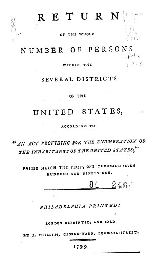
The 1790 United States census was the first United States census. It recorded the population of the whole United States as of Census Day, August 2, 1790, as mandated by Article 1, Section 2, of the Constitution and applicable laws. In the first census, the population of the United States was enumerated to be 3,929,214 inhabitants.
The 1810 United States census was the third census conducted in the United States. It was conducted on August 6, 1810. It showed that 7,239,881 people were living in the United States, of whom 1,191,362 were slaves.
The 1820 United States census was the fourth census conducted in the United States. It was conducted on August 7, 1820. The 1820 census included six new states: Louisiana, Indiana, Mississippi, Illinois, Alabama and Maine. There has been a district wide loss of 1820 census records for Arkansas Territory, Missouri Territory, and New Jersey.
The 1830 United States census, the fifth census undertaken in the United States, was conducted on June 1, 1830. The only loss of census records for 1830 involved some countywide losses in Massachusetts, Maryland, and Mississippi.
The District of Columbia is a federal district with an ethnically diverse population. In 2020, the District had a population of 689,545 people, with a resident density of 11,515 people per square mile.