Halfmoon, New York

Last updated

Halfmoon
Town of Halfmoon
Twinbridges.jpg
Halfmoon NY flag.jpg
Halfmoon Saratoga NY.png
Location within Saratoga County
USA New York location map.svg
Red pog.svg
Halfmoon
Location within the state of New York
Coordinates: 42°51′24″N73°44′33″W / 42.85667°N 73.74250°W / 42.85667; -73.74250
Country United States
State New York
County Saratoga
Settled1788
Named for Halve Maen
Government
  SupervisorKevin Tollisen (R)
Area
[1]
  Total33.63 sq mi (87.10 km2)
  Land32.58 sq mi (84.38 km2)
  Water1.05 sq mi (2.72 km2)
Elevation
282 ft (86 m)
Population
 (2020)
  Total25,662
  Density787.66/sq mi (304.12/km2)
Time zone UTC-5 (Eastern (EST))
  Summer (DST) UTC-4 (EDT)
ZIP code
12065 & 12118
Area code 518
FIPS code 36-31489
GNIS feature ID0979035
Website Town website

Halfmoon is a town in Saratoga County, New York, United States. The population was 25,662 at the 2020 census. The town is apparently named for the shape of the lower elevation land north of the junction of the Hudson and Mohawk Rivers. It is also said to be named for Henry Hudson's ship, the Halve Maen.

Contents

Halfmoon is in the southeastern part of the county and is north of Albany.

History

The earliest settlements took place circa 1680 by the Mohawk River.

The town was formed while still part of Albany County in 1788. The name was briefly changed to Orange when the town of Waterford was created in 1816 from part of Halfmoon; however, the current name was restored in 1820. In 1828, the western portion of the town was used to create the town of Clifton Park.

The Erie Canal was built along the southern part of Halfmoon, part of the Mohawk River. [2]

Geography

According to the United States Census Bureau, the town has a total area of 33.7 square miles (87 km2), of which 32.7 square miles (85 km2) is land and 1.0 square mile (2.6 km2) (3.00%) is water.

The southern town line, delineated by the Mohawk River, is the border of Albany County. The eastern town line, at the Hudson River, is the border of Rensselaer County. The northern town line is marked by the Anthony Kill, a tributary of the Hudson River.

Interstate 87, the Adirondack Northway, is a six-lane north–south freeway along the western edge of Halfmoon. U.S. Route 9 parallels the interstate farther to the east and crosses into the town from Albany County on the Crescent Bridge. New York State Route 146, an east–west highway, intersects US-9 at the hamlet of Clifton Park. U.S. Route 4 is a north–south highway in the eastern part of the town. New York State Route 236 is a short state highway linking NY-146 to US-9.

Demographics

Historical population
CensusPop.Note
1820 4,024
1830 2,042−49.3%
1840 2,63128.8%
1850 2,7886.0%
1860 3,13012.3%
1870 3,093−1.2%
1880 3,1020.3%
1890 3,73220.3%
1900 5,10136.7%
1910 5,98017.2%
1920 1,534−74.3%
1930 1,73913.4%
1940 1,96913.2%
1950 2,83644.0%
1960 4,12045.3%
1970 9,287125.4%
1980 11,86027.7%
1990 13,87917.0%
2000 18,47433.1%
2010 21,53516.6%
2020 25,66219.2%
U.S. Decennial Census [3]

As of the census [4] of 2000, there were 18,474 people, 7,778 households, and 4,861 families residing in the town. The population density was 565.9 inhabitants per square mile (218.5/km2). There were 8,172 housing units at an average density of 250.3 per square mile (96.6/km2). The racial makeup of the town was 94.94% White, 1.27% African American, 0.17% Native American, 1.89% Asian, 0.02% Pacific Islander, 0.41% from other races, and 1.30% from two or more races. Hispanic or Latino of any race were 1.65% of the population.

There were 7,778 households, out of which 30.3% had children under the age of 18 living with them, 49.9% were married couples living together, 9.0% had a female householder with no husband present, and 37.5% were non-families. 29.1% of all households were made up of individuals, and 7.1% had someone living alone who was 65 years of age or older. The average household size was 2.35 and the average family size was 2.93.

In the town, the population was spread out, with 23.7% under the age of 18, 6.9% from 18 to 24, 36.3% from 25 to 44, 22.5% from 45 to 64, and 10.6% who were 65 years of age or older. The median age was 36 years. For every 100 females, there were 94.7 males. For every 100 females age 18 and over, there were 91.4 males.

The median income for a household in the town was $46,234, and the median income for a family was $53,515. Males had a median income of $40,076 versus $30,512 for females. The per capita income for the town was $23,714. About 3.7% of families and 4.5% of the population were below the poverty line, including 5.6% of those under age 18 and 6.4% of those age 65 or over.

Notable people

Education

The Town of Halfmoon falls within three school districts: [5]

Communities and locations in Halfmoon

Related Research Articles

<span class="mw-page-title-main">Saratoga County, New York</span> County in New York, United States

Saratoga County is a county in the U.S. state of New York, and is the fastest-growing county in Upstate New York. As of the 2020 U.S. census, the county's population was enumerated at 235,509, its highest decennial count ever and a 7.2% increase from the 219,607 recorded at the 2010 census, representing one of the fastest growth rates in the northeastern United States; and despite the worldwide toll of the COVID-19 pandemic in the early 2020s, Saratoga County has continued its rapid growth. The county seat is Ballston Spa. The county is part of the Capital District region of the state.

<span class="mw-page-title-main">Cohoes, New York</span> City in New York, United States

Cohoes is an incorporated city located in the northeast corner of Albany County in the U.S. state of New York. It is called the "Spindle City" because of the importance of textile manufacturing to its growth in the 19th century. The city's factories processed cotton from the Deep South.

<span class="mw-page-title-main">Montezuma, New York</span> Town in New York, United States

Montezuma is a town in Cayuga County, New York, United States. The population was 1,277 at the 2010 census.

<span class="mw-page-title-main">Danube, New York</span> Town in New York, United States

Danube is a town in Herkimer County, New York, United States. The population was 801 at the 2020 census, down from 1,039 in 2010. Early Palatine German immigrants in the eighteenth century named the town after the Danube River in Europe.

<span class="mw-page-title-main">Florida, Montgomery County, New York</span> Town in New York, United States

Florida is a town south of the Mohawk River in Montgomery County, New York, United States. The population was 2,696 in the 2010 United States Census. The town was named after the state of Florida. It is located in the eastern end of Montgomery County and is south of the City of Amsterdam, which it borders.

<span class="mw-page-title-main">Root, New York</span> Town in New York, United States

Root is a town in Montgomery County, New York, United States. The population was 1,715 at the 2010 census. The town was named for Erastus Root, a legislator in the early Federal period.

<span class="mw-page-title-main">Deerfield, New York</span> Town in New York, United States

Deerfield is a town in Oneida County, New York, United States. The population was 4,273 at the 2010 census.

<span class="mw-page-title-main">Ballston, New York</span> Town in New York, United States

Ballston is a town in Saratoga County, New York, United States. The population was 11,831 at the 2020 census. The name is derived from an early settler, Eliphalet Ball, a Presbyterian minister who relocated there from Westchester County, New York in 1770. The town is in the southern part of the county, and is north of Schenectady.

<span class="mw-page-title-main">Clifton Park, New York</span> Town in New York, United States

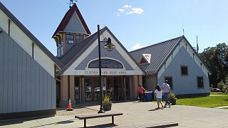
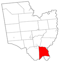
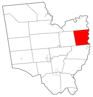
Clifton Park is a suburban town in Saratoga County, New York, United States. It is the largest municipality in the county, with a 2020 population of 38,029, according to the 2020 census. The name is derived from an early land patent. The town is in the southern part of Saratoga County, approximately 12 miles (19 km) north of Albany, 7 miles (11 km) northeast of Schenectady, and 10 miles (16 km) south of Saratoga Springs.

<span class="mw-page-title-main">Mechanicville, New York</span> City in New York, United States

Mechanicville is a city in Saratoga County, New York, United States. The population was 5,163 at the 2020 census, a small decrease from 5,196 in 2010. It is the smallest city by area in the state. The name is derived from the occupations of early residents.

<span class="mw-page-title-main">Northumberland, New York</span> Town in New York, United States

Northumberland is a town in Saratoga County, New York, United States. Immediately north of Schuylerville and northeast of Saratoga Springs the town is also located on the west bank of the Hudson River.

<span class="mw-page-title-main">Saratoga, New York</span> Town in New York, United States

Saratoga is a town in Saratoga County, New York, United States. The population was 5,808 at the 2020 census. It is also the commonly used, but not official, name for the neighboring and much more populous city, Saratoga Springs. The major village in the town of Saratoga is Schuylerville, which is often, but not officially, called Old Saratoga. Saratoga contains a second village, named Victory.

<span class="mw-page-title-main">Little Falls (town), New York</span> Town in New York, United States

Little Falls is a town in Herkimer County, New York, United States. The population was 1,587 at the 2010 census. The town is named after falls and rapids on the Mohawk River nearby.

<span class="mw-page-title-main">Amsterdam (town), New York</span> Town in New York, United States

Amsterdam is a town in Montgomery County, New York, United States. The population was 5,566 at the 2010 census. The town is named after Amsterdam, the capital of the Netherlands.

<span class="mw-page-title-main">Schaghticoke, New York</span> Town in New York, United States

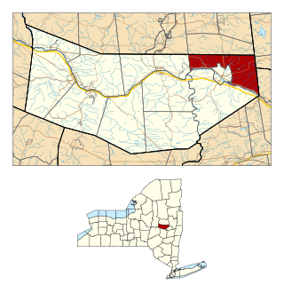
SchaghticokeSKAT-i-kohk is a town in Rensselaer County, New York, United States. The population was 7,445 at the 2020 census. It was named for the Schaghticoke, a Native American tribe formed in the seventeenth century from an amalgamation of remnant peoples of eastern New York and New England. The tribe has one of the oldest reservations in the United States, located in what is now Litchfield County, Connecticut. It has been recognized by the state of Connecticut but has not yet achieved federal recognition.

<span class="mw-page-title-main">Stillwater, New York</span> Town in New York, United States

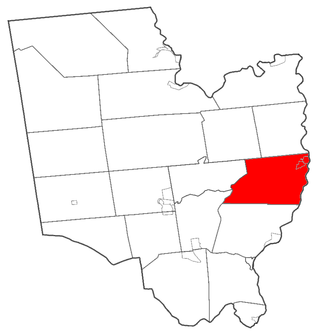
Stillwater is a town in Saratoga County, New York, United States, with a population of 9,022 at the 2020 census. The town contains a village called Stillwater. The town is at the eastern border of the county, southeast of Saratoga Springs and borders both Rensselaer and Washington counties. Saratoga National Historical Park is located within the town's limits. There is a hamlet in Minerva, Essex County, New York, with the same name which has nothing to do with this town.

<span class="mw-page-title-main">Waterford (village), New York</span> Village in New York, United States

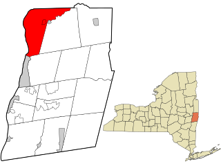
Waterford is a village in Saratoga County, New York, United States. The population was 2,038 at the 2020 census. The name derives from the ford between the mainland and Peebles Island.

<span class="mw-page-title-main">Waterford, New York</span> Town in New York, United States

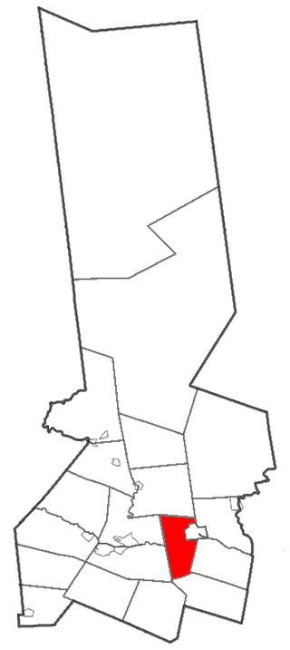
Waterford is a town in Saratoga County, New York, United States. The population was 8,208 at the 2020 census. The name of the town is derived from its principal village, also called Waterford. The town is located in the southeast corner of Saratoga County and north-northwest of Troy at the junction of the Erie Canal and the Hudson River.

<span class="mw-page-title-main">Mohawk Valley</span> Six-county region in New York, United States

The Mohawk Valley region of the U.S. state of New York is the area surrounding the Mohawk River, sandwiched between the Adirondack Mountains and Catskill Mountains, northwest of the Capital District. As of the 2010 United States Census, the region's counties have a combined population of 622,133 people. In addition to the Mohawk River valley, the region contains portions of other major watersheds such as the Susquehanna River.

<span class="mw-page-title-main">Mohawk Towpath Scenic Byway</span>

The Mohawk Towpath Scenic Byway is a National Scenic Byway in the Capital District region of New York in the United States. It extends from Schenectady to Waterford by way of a series of local, county, and state highways along the Mohawk River and the Erie Canal. The byway is intended to showcase the history of the waterway, from Native American times through the creation of the Erie Canal and the role the waterside communities played in the Industrial Revolution and the westward expansion of the United States. At its east end, the byway connects to the Lakes to Locks Passage, an All-American Road.

References

  1. "2016 U.S. Gazetteer Files". United States Census Bureau. Retrieved July 5, 2017.
  2. "The Erie Canal in Halfmoon & Clifton Park · The Erie Canal in Saratoga County · The Erie Canal in Saratoga County". cpheriecanal.omeka.net. Retrieved May 28, 2024.
  3. "Census of Population and Housing". Census.gov. Retrieved June 4, 2015.
  4. "U.S. Census website". United States Census Bureau . Retrieved January 31, 2008.
  5. "School Payments". Town of Halfmoon, New York. Retrieved July 24, 2002.