Franklin County, Virginia

Last updated

Franklin County
Franklin County Courthouse Rocky Mount Virginia.JPG
Franklin County Courthouse in May 2010
Map of Virginia highlighting Franklin County.svg
Location within the U.S. state of Virginia
Virginia in United States.svg
Virginia's location within the U.S.
Coordinates: 36°59′N79°53′W / 36.99°N 79.88°W / 36.99; -79.88
CountryFlag of the United States.svg United States
StateFlag of Virginia.svg  Virginia
Founded1785
Named for Benjamin Franklin
Seat Rocky Mount
Largest townRocky Mount
Area
  Total712 sq mi (1,840 km2)
  Land690 sq mi (1,800 km2)
  Water21 sq mi (50 km2)  3.0%
Population
 (2020)
  Total54,477 Decrease2.svg
  Density77/sq mi (30/km2)
Time zone UTC−5 (Eastern)
  Summer (DST) UTC−4 (EDT)
Congressional district 9th
Website www.franklincountyva.gov

Franklin County is located in the Blue Ridge foothills of the Commonwealth of Virginia. As of the 2020 census, the population was 54,477. [1] Its county seat is Rocky Mount. [2] Franklin County is part of the Roanoke Metropolitan Statistical Area and is located in the Roanoke Region of Virginia. [3] The Roanoke River forms its northeast boundary with Bedford County.

Contents

History

Franklin County historic marker, State of Virginia Franklin County Virginia historic marker.JPG
Franklin County historic marker, State of Virginia

The Blue Ridge Foothills had long been inhabited by Native Americans. At the time of European encounter, mostly Siouan-speaking tribes lived in this area.

A few colonists moved into the area before the American Revolutionary War, but most settlement happened afterward, as people moved west seeking new lands. Cultivation of tobacco had exhausted soils in the eastern part of the state. The county was formed in 1785 from parts of Bedford and Henry counties. It was named for Benjamin Franklin. [4] The Piedmont and backcountry areas were largely settled by Scots-Irish, who were the last major immigrant group from the British Isles to enter the colonies before the Revolutionary War. There were also migrants from coastal areas, including free people of color, who moved to the frontier to escape racial strictures associated with the slave society of Virginia. [5]

The Great Moonshine Conspiracy era

In the 20th century during Prohibition, local wits named Franklin County the "Moonshine Capital of the World", as moonshine production and bootlegging drove the economy. As of 2000, the local chamber of commerce had adopted the title as a heritage identification for the area. Moonshine is still being made in the area. [6]

Historians estimate that in the 1920s, 99 of every 100 Franklin County residents were in some way involved in the illegal liquor trade. [7] The bootleggers became involved with gangsters from Chicago and other major cities, and some local law enforcement officials were part of the criminal activities and killing of competitors. [8] "Between 1930 and 1935 local still operators and their business partners sold a volume of whiskey that would have generated $5,500,000 in excise taxes at the old 1920 tax rate." [8]

A lengthy federal investigation resulted in indictments and trials for 34 suspects in 1935 for what was called the "Great Moonshine Conspiracy," which attracted national attention. The writer Sherwood Anderson was among the many outsiders who came to cover the trial. At what was then the longest trial in state history, 31 people were convicted, but their jail sentences were relatively light (two years or less). Thirteen conspirators were sentenced only to probation. [8]

This period has recently received new attention by writers. T. Keister Greer's history The Great Moonshine Conspiracy Trial of 1935 (2002) covered the trial and its background in the county. [9] The writer Matt Bondurant had ancestors in the area, whose exploits during this period inspired his historical novel, The Wettest County in the World (2008). (The title was based on a statement by Anderson.) The book was adapted as a film, Lawless , in 2012. In 2014 an historical novel with much history about the county and town came out: "Moonshine Corner, Keys to Rocky Mount," ISBN   9781500980115, by the widow of T. Keister Greer, Ibby Greer.

Late 20th century to present

Since the 1980s, much residential development has occurred around Smith Mountain Lake. People live there who commute to work in the urbanized areas of Roanoke, Lynchburg, Martinsville, and Danville. Retirees have also moved in, and both groups have increased the county's population.

Geography

According to the U.S. Census Bureau, the county has a total area of 712 square miles (1,840 km2), of which 690 square miles (1,800 km2) is land and 21 square miles (54 km2) (3.0%) is water. [10] It is upriver of the fall line of the Roanoke River, located at Roanoke Rapids, North Carolina.

Districts

The county is divided into supervisor districts; a few are: Blackwater, Blue Ridge, Boones Mill, Gills Creek, Rocky Mount, Snow Creek, Union Hall, Ferrum, Glade Hill, Penhook, and Callaway

Adjacent counties

National protected areas

Major highways

Demographics

Historical population
CensusPop.Note
1790 6,842
1800 9,30236.0%
1810 10,72415.3%
1820 12,01712.1%
1830 14,91124.1%
1840 15,8326.2%
1850 17,43010.1%
1860 20,09815.3%
1870 18,264−9.1%
1880 25,08437.3%
1890 24,985−0.4%
1900 25,9533.9%
1910 26,4802.0%
1920 26,283−0.7%
1930 24,337−7.4%
1940 25,8646.3%
1950 24,560−5.0%
1960 25,9255.6%
1970 26,8583.6%
1980 35,74033.1%
1990 39,54910.7%
2000 47,28619.6%
2010 56,15918.8%
2020 54,477−3.0%
U.S. Decennial Census [11]
1790-1960 [12] 1900-1990 [13]
1990-2000 [14] 2010 [15] 2020 [16]

2020 census

Franklin County, Virginia – Racial and ethnic composition
Note: the US Census treats Hispanic/Latino as an ethnic category. This table excludes Latinos from the racial categories and assigns them to a separate category. Hispanics/Latinos may be of any race.
Race / Ethnicity (NH = Non-Hispanic)Pop 2010 [15] Pop 2020 [16] % 2010% 2020
White alone (NH)49,07246,21887.38%84.84%
Black or African American alone (NH)4,5413,8488.09%7.06%
Native American or Alaska Native alone (NH)112750.20%0.14%
Asian alone (NH)2513030.45%0.56%
Pacific Islander alone (NH)10200.02%0.04%
Some Other Race alone (NH)1441530.26%0.28%
Mixed Race or Multi-Racial (NH)6051,9051.08%3.50%
Hispanic or Latino (any race)1,4241,9552.54%3.59%
Total56,15954,477100.00%100.00%

2000 Census

As of the census [17] of 2000, there were 47,286 people, 18,963 households, and 13,918 families residing in the county. The population density was 68 people per square mile (26 people/km2). There were 22,717 housing units at an average density of 33 units per square mile (13 units/km2). The racial makeup of the county was 88.95% White, 9.35% Black or African American, 0.19% Native American, 0.36% Asian, 0.02% Pacific Islander, 0.42% from other races, and 0.71% from two or more races. 1.21% of the population were Hispanic or Latino of any race.

There were 18,963 households, out of which 29.10% had children under the age of 18 living with them, 60.10% were married couples living together, 9.40% had a female householder with no husband present, and 26.60% were non-families. 22.60% of all households were made up of individuals, and 8.90% had someone living alone who was 65 years of age or older. The average household size was 2.44 and the average family size was 2.84.

In the county, the population was spread out, with 22.20% under the age of 18, 8.10% from 18 to 24, 28.20% from 25 to 44, 27.20% from 45 to 64, and 14.30% who were 65 years of age or older. The median age was 40 years. For every 100 females there were 97.20 males. For every 100 females age 18 and over, there were 96.30 males.

The median income for a household in the county was $38,056, and the median income for a family was $45,163. Males had a median income of $29,807 versus $22,215 for females. The per capita income for the county was $19,605. About 7.30% of families and 9.70% of the population were below the poverty line, including 12.70% of those under age 18 and 9.80% of those age 65 or over.

Government

Board of supervisors

Constitutional officers

Franklin is represented by Republicans David Suetterlein and Bill Stanley in the Virginia Senate, Republicans Wren Williams and Kathy Byron in the Virginia House of Delegates, and Morgan Griffith in the U.S. House of Representatives.

Education

Franklin County Public Schools operates public schools serving the county. The school system includes 12 elementary schools, one middle school, and one high school.

Middle School - Benjamin Franklin Middle School(BFMS), VA

High School - Franklin County High School(FCHS), VA

About four miles outside of Callaway is the Phoebe Needles Mission School, an Episcopal mission school dating from 1907. The school and mission church were used to serve the rural and mountain children of the county who could not get to the public schools in Callaway, Ferrum, or Rocky Mount. The school has now become a church parish, Center for Lifelong Learning and summer camp operated by the Episcopal Diocese of Southwestern Virginia.

Ferrum College was established in 1913. Ferrum College offers bachelor's degrees in twenty-eight major degree programs. The college continues to operate under the auspices of the Virginia Annual Conference of the United Methodist Church and the United Methodist Women of the Virginia Annual Conference.

United States presidential election results for Franklin County, Virginia [18]
Year Republican Democratic Third party
No.%No.%No.%
2020 20,89570.35%8,38128.22%4261.43%
2016 18,56968.85%7,25726.91%1,1454.25%
2012 16,71862.60%9,09034.04%8993.37%
2008 15,41460.68%9,61837.86%3691.45%
2004 14,04863.21%8,00236.01%1730.78%
2000 11,22559.62%7,14537.95%4592.44%
1996 7,38243.46%7,30042.97%2,30513.57%
1992 6,72442.83%6,59041.97%2,38715.20%
1988 7,39155.73%5,73443.24%1361.03%
1984 7,68460.21%4,90338.42%1751.37%
1980 4,99345.02%5,68551.26%4123.72%
1976 3,53234.63%6,43963.13%2282.24%
1972 4,67465.74%2,27331.97%1632.29%
1968 3,03636.54%2,02524.37%3,24739.08%
1964 2,27939.72%3,44760.08%110.19%
1960 2,08041.47%2,92458.29%120.24%
1956 2,12548.81%2,14249.20%872.00%
1952 1,97649.08%2,01249.98%380.94%
1948 1,10039.10%1,34347.74%37013.15%
1944 1,20637.41%2,00262.10%160.50%
1940 92531.17%2,03768.63%60.20%
1936 97529.80%2,28569.83%120.37%
1932 81226.39%2,24572.96%200.65%
1928 1,52945.10%1,86154.90%00.00%
1924 1,07735.98%1,90263.55%140.47%
1920 1,38143.83%1,76556.01%50.16%
1916 1,09442.37%1,48157.36%70.27%
1912 41518.35%1,23854.73%60926.92%

Communities

Towns

Census-designated places

Other unincorporated communities

Notable people

See also

Related Research Articles

<span class="mw-page-title-main">Montgomery County, Virginia</span> County in Virginia, United States

Montgomery County is a county located in the Valley and Ridge area of the U.S. state of Virginia. As population in the area increased, Montgomery County was formed in 1777 from Fincastle County, which in turn had been taken from Botetourt County. As of the 2020 census, the population was 99,721. Its county seat is Christiansburg, and Blacksburg is the largest town. Montgomery County is part of the Blacksburg-Christiansburg metropolitan area. It is dominated economically by the presence of Virginia Tech, Virginia's third largest public university, which is the county's largest employer.

<span class="mw-page-title-main">Roanoke County, Virginia</span> County in Virginia, United States

Roanoke County is a county located in the U.S. state of the Commonwealth of Virginia. As of the 2020 census, the population was 96,929. Its county seat is Salem, but the county administrative offices are located in the census-designated place of Cave Spring.

<span class="mw-page-title-main">Patrick County, Virginia</span> County in Virginia, United States

Patrick County is a county located on the central southern border of the Commonwealth of Virginia. As of the 2020 census, the county's population was 17,608. Its county seat is Stuart. It is located within both the rolling hills and valleys of the Piedmont Region and the more mountainous regions of Southwest Virginia.

<span class="mw-page-title-main">Galax, Virginia</span> Independent city in Virginia, United States

Galax is an independent city in the southwestern part of the Commonwealth of Virginia. As of the 2020 census, the population was 6,720.

<span class="mw-page-title-main">Floyd County, Virginia</span> County in Virginia, United States

Floyd County is a county located in the Commonwealth of Virginia. As of the 2020 census, the population was 15,476. Its county seat is the town of Floyd. Floyd County is included in the Blacksburg-Christiansburg, VA Metropolitan Statistical Area. Named after Virginia politician John Floyd, the county was established in 1831. The county is located on the high plateau of the Blue Ridge Mountains and surrounded by the Little River. In the 1960s and 1970s, Floyd proved popular with people in the era's counterculture, particularly those who wanted to live in closer contact with nature.

<span class="mw-page-title-main">Buena Vista, Virginia</span> Independent city in Virginia, United States

Buena Vista is an independent city located in the Blue Ridge Mountains region of Virginia in the United States. As of the 2020 census, the population was 6,641. The Bureau of Economic Analysis combines the independent cities of Buena Vista and Lexington, along with surrounding Rockbridge County, for statistical purposes.

<span class="mw-page-title-main">Botetourt County, Virginia</span> County in Virginia, United States

Botetourt County is a US county that lies in the Roanoke Region of Virginia. Located in the mountainous portion of the state, the county is bordered by two major ranges, the Blue Ridge Mountains and the Appalachian Mountains.

<span class="mw-page-title-main">Bedford County, Virginia</span> County in Virginia, United States

Bedford County is a United States county located in the Piedmont region of the Commonwealth of Virginia. Its county seat is the town of Bedford, which was an independent city from 1968 until rejoining the county in 2013.

<span class="mw-page-title-main">Northampton County, North Carolina</span> County in North Carolina, United States

Northampton County is a county located in the U.S. state of North Carolina. As of the 2020 census, the population was 17,471. Its county seat is Jackson.

<span class="mw-page-title-main">Blue Ridge, Virginia</span> Census-designated place in Virginia, United States

Blue Ridge is a census-designated place (CDP) in southern Botetourt County, Virginia, United States. The population was 3,185 at the 2020 census. The CDP is located along U.S. Route 460. It is part of the Roanoke Metropolitan Statistical Area.

<span class="mw-page-title-main">Boones Mill, Virginia</span> Town in Virginia, United States

Boones Mill is a town in Franklin County, Virginia, United States. The population was 239 in 2018, down from 285 at the 2000 census.

<span class="mw-page-title-main">Ferrum, Virginia</span> CDP in Virginia, United States

Ferrum is a census-designated place (CDP) in Franklin County, Virginia, United States. The population was 2,043 at the 2010 census, an increase of over fifty percent from the 1,313 reported in 2000. Ferrum is home to Ferrum College and its Blue Ridge Folklife Festival. It is part of the Roanoke Metropolitan Statistical Area.

North Shore is a census-designated place (CDP) in Franklin County, Virginia, United States. The community lies along State Route 616. It is part of the Roanoke Metropolitan Statistical Area.

<span class="mw-page-title-main">Rocky Mount, Virginia</span> Town in Virginia, United States

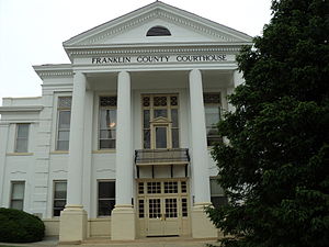
Rocky Mount is a town in and the county seat of Franklin County, Virginia, United States. The town is part of the Roanoke Metropolitan Statistical Area, and had a population of 4,903 as of the 2020 census. It is located in the Roanoke Region of Virginia.

<span class="mw-page-title-main">Vinton, Virginia</span> Town in Virginia, United States

Vinton is a town in eastern Roanoke County, Virginia, United States. The population was 8,059 at the 2020 census. Vinton is part of the Roanoke Metropolitan Statistical Area and the Roanoke Region of Virginia.

<span class="mw-page-title-main">Roanoke metropolitan area</span> Metropolitan area in Virginia, United States

The Roanoke Metropolitan Statistical Area is a Metropolitan Statistical Area (MSA) in Virginia as defined by the United States Office of Management and Budget (OMB). The Roanoke MSA is sometimes referred to as the Roanoke Valley, even though the Roanoke MSA occupies a larger area than the Roanoke Valley. It is geographically similar to the area known as the Roanoke Region of Virginia, but while the latter includes Alleghany County, the former does not. As of the 2020 census, the MSA had a population of 315,251.

The Roanoke Valley in southwest Virginia is an area adjacent to and including the Roanoke River between the Blue Ridge Mountains to the east and the Appalachian Plateau to the west. The valley includes much of Roanoke County, as well as the two independent cities of Roanoke and Salem.

The Roanoke Region is the area of the Commonwealth of Virginia surrounding the city of Roanoke. Its usage may refer to the metropolitan statistical area or the Roanoke Valley, but it sometimes includes areas in the Allegheny Mountains and New River Valley which includes Alleghany County, Montgomery County, Covington, Clifton Forge, Blacksburg, Christiansburg, and Radford. Bedford County and Floyd County are sometimes included as part of the region.

<span class="mw-page-title-main">Callaway, Virginia</span> Unincorporated community in Virginia, United States

Callaway is an unincorporated community in Franklin County, Virginia, United States. Callaway is 8.8 miles (14.2 km) west of Rocky Mount. Callaway has a post office with ZIP code 24067, which opened on July 14, 1871.

<span class="mw-page-title-main">Washington Iron Furnace</span> United States historic place

Washington Iron Furnace is an historic iron furnace, located in Rocky Mount, Franklin County, Virginia. The granite furnace was built around 1770, and measures 30 feet high on its south face. It helped establish industry in the county, and was listed on the National Register of Historic Places in 1973.

References

  1. "Franklin County, Virginia". United States Census Bureau . Retrieved January 30, 2022.
  2. "Find a County". National Association of Counties. Archived from the original on May 31, 2011. Retrieved June 7, 2011.
  3. "Home - Roanoke Regional Partnership". Roanoke Regional Partnership. Archived from the original on June 13, 2009. Retrieved May 13, 2018.
  4. Gannett, Henry (1905). The Origin of Certain Place Names in the United States. Govt. Print. Off. pp.  131.
  5. Paul Heinegg, Free African Americans in Virginia, North and South Carolina, Maryland and Delaware, 2005
  6. "Making Illegal Liquor and profits in Appalachian Hills" Archived October 22, 2007, at the Wayback Machine , CNN, August 28, 2000
  7. America: The Story of Us , television documentary, 2010, The History Channel
  8. 1 2 3 Moonshine - Blue Ridge Style Archived June 23, 2013, at the Wayback Machine , Blue Ridge Institute, accessed May 17, 2013
  9. Review: "The Great Moonshine Conspiracy Trial of 1935 by T. Keister Greer", Blue Ridge Traditions Magazine, 2002, ISBN   0-9722355-1-5 Magazine has closed down, referring to archive.org image instead.
  10. "US Gazetteer files: 2010, 2000, and 1990". United States Census Bureau. February 12, 2011. Retrieved April 23, 2011.
  11. "Census of Population and Housing from 1790-2000". US Census Bureau . Retrieved January 24, 2022.
  12. "Historical Census Browser". University of Virginia Library. Archived from the original on August 11, 2012. Retrieved January 2, 2014.
  13. "Population of Counties by Decennial Census: 1900 to 1990". United States Census Bureau. Archived from the original on December 15, 2013. Retrieved January 2, 2014.
  14. "Census 2000 PHC-T-4. Ranking Tables for Counties: 1990 and 2000" (PDF). United States Census Bureau. Archived (PDF) from the original on December 18, 2014. Retrieved January 2, 2014.
  15. 1 2 "P2 Hispanic or Latino, and Not Hispanic or Latino by Race – 2010: DEC Redistricting Data (PL 94-171) - Franklin County, Virginia". United States Census Bureau .
  16. 1 2 "P2 Hispanic or Latino, and Not Hispanic or Latino by Race – 2020: DEC Redistricting Data (PL 94-171) - Franklin County, Virginia". United States Census Bureau .
  17. "U.S. Census website". United States Census Bureau . Retrieved May 14, 2011.
  18. David Leip. "Dave Leip's Atlas of U.S. Presidential Elections". Uselectionatlas.org. Retrieved December 8, 2020.

36°59′N79°53′W / 36.99°N 79.88°W / 36.99; -79.88