North Shore, Virginia

Last updated
North Shore, Virginia
USA Virginia location map.svg
Red pog.svg
North Shore
Usa edcp location map.svg
Red pog.svg
North Shore
Coordinates: 37°4′47″N79°39′41″W / 37.07972°N 79.66139°W / 37.07972; -79.66139
Country United States
State Virginia
County Franklin
Area
  Total20.1 sq mi (52.1 km2)
  Land13.7 sq mi (35.4 km2)
  Water6.4 sq mi (16.7 km2)
Elevation
1,004 ft (306 m)
Population
 (2020)
  Total3,332
  Density170/sq mi (64/km2)
Time zone UTC−5 (Eastern (EST))
  Summer (DST) UTC−4 (EDT)
ZIP Code
24121 (Moneta)
24184 (Wirtz)
Area code(s) 540 and 826
FIPS code 51-57531 [1]
GNIS feature ID1852917 [2]

North Shore is a census-designated place (CDP) in Franklin County, Virginia, United States. The community lies along State Route 616. It is part of the Roanoke Metropolitan Statistical Area.

Contents

Westlake Corner borders the community to the north and northwest.

Geography

North Shore is located in northeastern Franklin County at 37°5′30″N79°39′4″W / 37.09167°N 79.65111°W / 37.09167; -79.65111 (37.091605, 79.651248). [3] It occupies a 6-mile-long (10 km) peninsula in Smith Mountain Lake, an impoundment on the Roanoke River. The northeast edge of the CDP follows the Roanoke River arm of the lake, which is also the Bedford County line, while the southern and southwestern edge follows the Blackwater River and Gills Creek arm. It is bordered to the north by the Westlake Corner CDP, with the border formed by Patience Lane, Gilford Road, Scruggs Road, and Lakewood Forest Road. [4] The unincorporated community of Scruggs is in the center of the North Shore CDP.

According to the United States Census Bureau, the North Shore CDP has a total area of 20.1 square miles (52.1 km2), of which 13.7 square miles (35.4 km2) is land and 6.4 square miles (16.7 km2), or 32.05%, is water. [5]

Demographics

2020 census

As of the census of 2020, there were 3,332 people residing in the CDP. There were 2,954 housing units. The racial makeup of the CDP was 95.0% White, 0.6% African American or Black, 0.2% American Indian, 0.4% Asian, 0.0% Pacific Islander, 0.4% from other races, and 3.5% from two or more races. Hispanic or Latino of any race were 1.4% of the population.

2010 census

As of the census of 2010, there were 3,094 people residing in the CDP. [5] There were 2,950 housing units. The racial makeup of the CDP was 97.3% White, 1.3% African American, 0.5% Native American, 0.3% Asian, 0.0% Pacific Islander, 0.2% from other races, and 0.4% from two or more races. Hispanic or Latino of any race were 1.0% of the population.

2000 census

As of the census [1] of 2000, there were 2,112 people, 994 households, and 748 families residing in the CDP. The population density was 154.6 people per square mile (59.7/km2). There were 1,919 housing units at an average density of 140.4/sq mi (54.2/km2). The racial makeup of the CDP was 98.11% White, 1.33% African American, 0.05% Native American, 0.09% Asian, 0.09% from other races, and 0.33% from two or more races. Hispanic or Latino of any race were 0.80% of the population.

There were 994 households, out of which 15.1% had children under the age of 18 living with them, 70.0% were married couples living together, 4.0% had a female householder with no husband present, and 24.7% were non-families. 21.2% of all households were made up of individuals, and 8.6% had someone living alone who was 65 years of age or older. The average household size was 2.12 and the average family size was 2.44.

In the CDP, the population was spread out, with 12.2% under the age of 18, 3.5% from 18 to 24, 18.4% from 25 to 44, 42.5% from 45 to 64, and 23.5% who were 65 years of age or older. The median age was 54 years. For every 100 females there were 99.6 males. For every 100 females age 18 and over, there were 98.8 males.

The median income for a household in the CDP was $55,288, and the median income for a family was $62,546. Males had a median income of $34,323 versus $24,612 for females. The per capita income for the CDP was $34,028. About 1.3% of families and 1.6% of the population were below the poverty line, including none of those under the age of eighteen or sixty-five or over.

Parks and recreation

Smith Mountain Lake Community Park, a public park maintained by the Franklin County Parks and Recreation Department is located within the CDP. The 37-acre park opened in June 2007 and includes walking trails, a fishing pier, playground, and community beach.

Crazy Horse Marina as well as the Virginia Department of Wildlife Resources operated Scruggs #8 offer public boating access sites to Smith Mountain Lake in North Shore.

The Waterfront Country Club, a country club is located within the CDP.

Government

The United States Postal Service does not operate a post office within the CDP. Addresses within North Shore use a Moneta or Wirtz ZIP Code.

Education

The community is served by Franklin County Public Schools. Public school students residing in North Shore are zoned to attend Dudley Elementary School, Benjamin Franklin Middle School, Franklin County High School.

The closest higher education institutions are located in Ferrum and Roanoke.

Infrastructure

Public safety

Law enforcement is provided by the Franklin County Sheriff's Office. Fire protection and emergency medical services are provided by the Scruggs Volunteer Fire Department and Rescue Squad, which operates a fire station within the CDP.

Transportation

Air

Smith Mountain Lake Airport is the closest general aviation airport to the CDP. The Roanoke-Blacksburg Regional Airport is the closest airport with commercial service to the CDP.

Highways

Rail

No rail lines are located within the CDP. The closest passenger rail service is located in Roanoke.

Related Research Articles

<span class="mw-page-title-main">Paisley, Florida</span> Census-designated place in Florida

Paisley is an unincorporated community and census-designated place (CDP) in Lake County, Florida, United States. The population was 818 at the 2010 census, up from 734 at the 2000 census. It is part of the Orlando–Kissimmee Metropolitan Statistical Area.

Fox Lake Hills is an unincorporated community and census-designated place (CDP) in Lake Villa Township, Lake County, Illinois, United States. Per the 2020 census, the population was 2,684.

<span class="mw-page-title-main">Lansdowne-Baltimore Highlands, Maryland</span> Former census-designated place in Maryland, United States

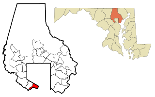
Lansdowne-Baltimore Highlands was a census-designated place (CDP) in Baltimore County, Maryland, United States. The population was 15,724 at the 2000 census. At the 2010 census the area was split into two separate CDPs, the unincorporated communities of Lansdowne and Baltimore Highlands.

<span class="mw-page-title-main">Lake Michigan Beach, Michigan</span> Census-designated place & unincorporated community in Michigan, United States

Lake Michigan Beach is an unincorporated community in Berrien County in the U.S. state of Michigan. It is a census-designated place (CDP) for statistical purposes, without any legal status as a municipality. The population was 1,216 at the 2010 census.

<span class="mw-page-title-main">Woodland Beach, Michigan</span> Census-designated place & unincorporated community in Michigan, United States

Woodland Beach is a census-designated place (CDP) and unincorporated community in Monroe County in the U.S. state of Michigan. The population was 1,899 at the 2020 census. The CDP is located within Frenchtown Charter Township.

<span class="mw-page-title-main">Gray Summit, Missouri</span> Census-designated place in Missouri, United States

Gray Summit is an unincorporated community and census-designated place (CDP) in Franklin County, Missouri, United States. The population was 2,701 at the 2010 census. Also called "Gray's Summit", it was founded by Daniel Gray of New York, who built a hotel here in 1845. It is located on Missouri Route 100 just north of Interstate 44.

<span class="mw-page-title-main">Vado, New Mexico</span> Place and community in the United States

Vado is an unincorporated community and census-designated place (CDP) in Doña Ana County, New Mexico, United States. The population was 3,194 at the 2010 census. The ZIP code for Vado is 88072, its area code is 575, and it is part of the Las Cruces Metropolitan Statistical Area.

<span class="mw-page-title-main">Wanchese, North Carolina</span> CDP in North Carolina, United States

Wanchese is a census-designated place (CDP) on Roanoke Island in Dare County, North Carolina, United States. It was named after Wanchese, the last known ruler of the Roanoke Native American tribe encountered by English colonists in the sixteenth century. The population was 1,642 at the 2010 census. Today, Wanchese is the center of commercial fishing and boatbuilding on the Outer Banks.

<span class="mw-page-title-main">South Rosemary, North Carolina</span> Census-designated place in North Carolina, United States

South Rosemary is an unincorporated area and census-designated place (CDP) in Halifax County, North Carolina, United States. The population was 2,836 at the 2010 census. It is part of the Roanoke Rapids, North Carolina Micropolitan Statistical Area.

<span class="mw-page-title-main">Westport, North Carolina</span> Census-designated place in North Carolina, United States

Westport is an unincorporated community and census-designated place (CDP) located in Lincoln County, North Carolina, United States. The population of the CDP was 4,026 at the 2010 census, up from 2,006 at the 2000 census. The community's name comes from its location on the west side of Lake Norman.

Cloverdale is a census-designated place (CDP) in southern Botetourt County, Virginia, United States. The population was 3,410 at the 2020 census. The community is located along State Route 654. It is part of the Roanoke Metropolitan Statistical Area.

Daleville is a census-designated place (CDP) in southern Botetourt County, Virginia, United States. The population was 3,070 at the 2020 census. The CDP is located along U.S. Route 220. It is part of the Roanoke Metropolitan Statistical Area.

Laymantown is a census-designated place (CDP) in southern Botetourt County, Virginia, United States. The population was 1,867 at the 2020 census. The community is located along State Route 658. It is part of the Roanoke Metropolitan Statistical Area.

<span class="mw-page-title-main">Troutville, Virginia</span> Town in Virginia, United States

Troutville is a town in Botetourt County, Virginia, United States. The population was 458 at the 2020 census. The town is located along the U.S. Route 11 between Cloverdale and Buchanan. It is part of the Roanoke Metropolitan Statistical Area.

Penhook is a census-designated place (CDP) in Franklin County, Virginia, United States. The population was 801 at the 2010 census, up from 726 in 2000. It is part of the Roanoke Metropolitan Statistical Area.

Westlake Corner is a census-designated place in Franklin County, Virginia, United States. The population was 1,553 at the 2020 census up fro 976 at the 2010 census. It is part of the Roanoke Metropolitan Statistical Area.

Elliston-Lafayette was a census-designated place (CDP) in Montgomery County, Virginia, United States. The population was 1,241 at the 2000 census; in 2010, Elliston and Lafayette were split into separate CDPs. It is part of the Blacksburg–Christiansburg Metropolitan Statistical Area, which encompasses all of Montgomery County, Virginia, including the towns of Blacksburg and Christiansburg, and the city of Radford. However, many residents of the eastern section of Montgomery County more often travel to Roanoke or Salem for work, shopping, and services since these cities are generally closer and do not require driving up Christiansburg Mountain on U.S. Route 460 or Interstate 81.

Cave Spring is a census-designated place (CDP) in Roanoke County, Virginia, United States. The population was 26,755 at the 2020 census. Cave Spring covers much of the area known locally as "Southwest County" which has the most affluent suburbs of Roanoke. It is part of the Roanoke Metropolitan Statistical Area.

<span class="mw-page-title-main">Tracyton, Washington</span> Census-designated place in Washington, United States

Tracyton is a census-designated place (CDP) in Kitsap County, Washington, United States. Its population was 5,233 at the 2010 census. It was named for 19th century Secretary of the Navy Benjamin F. Tracy.

Lake Royale is a census-designated place (CDP) in southeastern Franklin County, North Carolina, United States. The population was 3,392 at the 2020 census.

References

  1. 1 2 "U.S. Census website". United States Census Bureau . Retrieved 2008-01-31.
  2. "US Board on Geographic Names". United States Geological Survey. 2007-10-25. Retrieved 2008-01-31.
  3. "US Gazetteer files: 2010, 2000, and 1990". United States Census Bureau. 2011-02-12. Retrieved 2011-04-23.
  4. "TIGERweb". U.S. Census Bureau, Geography Division. Retrieved October 20, 2016.
  5. 1 2 "Geographic Identifiers: 2010 Demographic Profile Data (G001): North Shore CDP, Virginia". U.S. Census Bureau, American Factfinder. Retrieved October 20, 2016.[ dead link ]