Moneta, Virginia

Last updated
Moneta, Virginia
Lakes, VA, USA - panoramio - Idawriter.jpg
Railroad tracks near Moneta
USA Virginia location map.svg
Red pog.svg
Moneta, Virginia
Usa edcp location map.svg
Red pog.svg
Moneta, Virginia
Coordinates: 37°10′53″N79°37′2″W / 37.18139°N 79.61722°W / 37.18139; -79.61722 Coordinates: 37°10′53″N79°37′2″W / 37.18139°N 79.61722°W / 37.18139; -79.61722
Country United States
State Virginia
County Bedford
Area
  Total3.846 sq mi (9.96 km2)
  Land3.834 sq mi (9.93 km2)
  Water0.012 sq mi (0.03 km2)
Elevation
860 ft (260 m)
Population
 (2020)
  Total450
  Density120/sq mi (45/km2)
Time zone UTC-5 (Eastern (EST))
  Summer (DST) UTC-4 (EDT)
ZIP Code
24121
Area code(s) 540 and 826
FIPS code 51-52536
GNIS feature ID 2807404

Moneta is a census-designated place (CDP) in southern Bedford County, Virginia, United States. The community is located along Route 122 between the towns of Bedford and Rocky Mount. It is part of the Lynchburg Metropolitan Statistical Area.

Contents

History

Olive Branch Missionary Baptist Church and the Holland-Duncan House are listed on the National Register of Historic Places. [1]

On August 26, 2015, the community made news when journalists Alison Parker and Adam Ward were murdered on live television by former colleague Vester Flanagan at a nearby shopping center and marina. [2]

Geography

According to the United States Census Bureau, the CDP has a total area of 3.846 square miles (9.96 km²).

Demographics

Historical population
CensusPop.Note
2020 450
Source: U.S. Census Bureau

2020 census

The community was delineated by the United States Census Bureau for the first time during the 2020 census.

As of the census of 2020, there were 450 people residing in the CDP. There were 223 housing units. The racial makeup of the CDP was 81.8% White, 6.9% African American or Black, 0.0% American Indian, 0.7% Asian, 0.0% Pacific Islander, 2.4% from other races, and 8.2% from two or more races. Hispanic or Latino of any race were 6.7% of the population.

Parks and recreation

Moneta Park, a 119-acre public park maintained by the Bedford County Parks and Recreation Department, is located in the CDP. The park features two multi-use ball fields, a football field, an 18-hole disc golf course, picnic shelters, and walking trails. [3]

Waterwheel Marina, Bridgewater Marina, and Crystal Shores Marina Resort offer waterfront access to Smith Mountain Lake.

Government

The United States Postal Service operates the Moneta Post Office within the CDP. The Moneta ZIP Code extends to both sides of Smith Mountain Lake, including parts of Franklin County, since there is no Smith Mountain Lake postal address.

Education

The CDP is served by Bedford County Public Schools. Public school students residing in Moneta are zoned to attend Moneta Elementary School, Staunton River Middle School, and Staunton River High School.

The closest higher education institutions are located in Bedford, Lynchburg, and Roanoke.

Infrastructure

The Bedford Regional Water Authority operates a public water and wastewater system within the CDP.

Public safety

Law enforcement is provided by the Bedford County Sheriff's Office, which maintains a field office within the CDP. Fire protection is provided by Moneta Volunteer Fire Department, which operates three fire stations, including one within the CDP. Emergency medical services are provided by the Moneta Volunteer Rescue Squad and Bedford County Department of Fire and Rescue.

Transportation

Air

The Smith Mountain Lake Airport is the closest general aviation airport to Moneta. The Roanoke-Blacksburg Regional Airport and Lynchburg Regional Airport are the closest airports with commercial service.

Highways

Rail

The Norfolk Southern operated Altavista District runs through the CDP. The closest passenger rail service is located in Roanoke and Lynchburg.

Moneta was popularized as the filming location for scenes in the 1991 movie What About Bob? . In the movie, Bob arrived by bus with his goldfish and went into a local general store, which still stands, albeit in a disheveled state because it is no longer open.

Related Research Articles

<span class="mw-page-title-main">Bedford County, Virginia</span> County in Virginia, United States

Bedford County is a United States county located in the Piedmont region of the Commonwealth of Virginia. Its county seat is the town of Bedford, which was an independent city from 1968 until rejoining the county in 2013.

<span class="mw-page-title-main">Forest, Virginia</span> Census-designated place in Virginia, United States

Forest is a census-designated place (CDP) in eastern Bedford County, Virginia, United States. The population was 11,709 at the 2020 census. It is part of the Lynchburg Metropolitan Statistical Area.

<span class="mw-page-title-main">Blue Ridge, Virginia</span> Census-designated place in Virginia, United States

Blue Ridge is a census-designated place (CDP) in southern Botetourt County, Virginia, United States. The population was 3,185 at the 2020 census. The CDP is located along U.S. Route 460. It is part of the Roanoke Metropolitan Statistical Area.

Daleville is a census-designated place (CDP) in southern Botetourt County, Virginia, United States. The population was 3,070 at the 2020 census. The CDP is located along U.S. Route 220. It is part of the Roanoke Metropolitan Statistical Area.

Laymantown is a census-designated place (CDP) in southern Botetourt County, Virginia, United States. The population was 1,867 at the 2020 census. The community is located along State Route 658. It is part of the Roanoke Metropolitan Statistical Area.

<span class="mw-page-title-main">Troutville, Virginia</span> Town in Virginia, United States

Troutville is a town in Botetourt County, Virginia, United States. The population was 458 at the 2020 census. The town is located along the U.S. Route 11 between Cloverdale and Buchanan. It is part of the Roanoke Metropolitan Statistical Area.

North Shore is a census-designated place (CDP) in Franklin County, Virginia, United States. The community lies along State Route 616. It is part of the Roanoke Metropolitan Statistical Area.

<span class="mw-page-title-main">Vinton, Virginia</span> Town in Virginia, United States

Vinton is a town in eastern Roanoke County, Virginia, United States. The population was 8,059 at the 2020 census. Vinton is part of the Roanoke Metropolitan Statistical Area and the Roanoke Region of Virginia.

<span class="mw-page-title-main">Smith Mountain Lake</span> Body of water

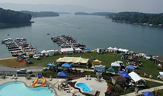
Smith Mountain Lake is a large reservoir in the Roanoke Region of Virginia, United States, located southeast of the City of Roanoke and southwest of Lynchburg. The lake was created in 1963 by the Smith Mountain Dam impounding the Roanoke River. The majority of the south shore of the lake lies in Franklin County while a small portion, including access to the dam, lies in Pittsylvania County. Bedford County makes up the northern half of the lake with the Roanoke River as the dividing line. The lake has become a popular recreation spot and has also experienced significant development in the last decade. It is the largest lake contained entirely within the Commonwealth of Virginia.

<span class="mw-page-title-main">WDBJ</span> CBS affiliate in Roanoke, Virginia

WDBJ is a television station licensed to Roanoke, Virginia, United States, serving as the CBS affiliate for the Roanoke–Lynchburg market. It is owned by Gray Television alongside Danville-licensed MyNetworkTV affiliate WZBJ, channel 24. WDBJ and WZBJ share studios on Hershberger Road in northwest Roanoke; through a channel sharing agreement, the two stations transmit using WDBJ's spectrum from an antenna on Poor Mountain in Roanoke County.

<span class="mw-page-title-main">Hardy, Virginia</span> Unincorporated community in Virginia, United States

Hardy is an unincorporated community in southwestern Bedford County and northeastern Franklin County, Virginia, United States. The community lies along State Route 634 and is approximately nine miles southeast of Roanoke.

Thaxton is an unincorporated community in western Bedford County, Virginia, United States. The community is located along U.S. Route 460 between Bedford and Montvale. It is part of the Lynchburg Metropolitan Statistical Area.

Glen Wilton is a census-designated place (CDP) in northern Botetourt County, Virginia, United States. The population was 129 at the 2020 census. The CDP is located along the James River, between Eagle Rock and Iron Gate. It is part of the Roanoke Metropolitan Statistical Area.

<span class="mw-page-title-main">Big Island, Virginia</span> Census-designated place in Virginia, United States

Big Island is a census-designated place (CDP) in northern Bedford County, Virginia, United States. The population as of the 2020 United States census was 300. The CDP is located along the James River and U.S. Route 501, between Glasgow and Coleman Falls. It is part of the Lynchburg Metropolitan Statistical Area.

<span class="mw-page-title-main">Montvale, Virginia</span> Census-designated place in Virginia, United States

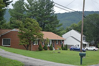
Montvale is a census-designated place (CDP) in western Bedford County, Virginia, United States. The population as of the 2020 census was 635. The community is located between Roanoke and Bedford. It is part of the Lynchburg Metropolitan Statistical Area.

<span class="mw-page-title-main">Chamblissburg, Virginia</span> Unincorporated community in Virginia, United States

Chamblissburg is an unincorporated community in southwestern Bedford County, Virginia, United States. It lies along State Route 24, east of Stewartsville. It is part of the Lynchburg Metropolitan Statistical Area.

<span class="mw-page-title-main">Huddleston, Virginia</span> Unincorporated community in Virginia, United States

Huddleston is an unincorporated community in southeastern Bedford County, Virginia, United States. The community lies along State Route 626 and is located 12.5 miles (20.1 km) south-southeast of Bedford. It is part of the Lynchburg Metropolitan Statistical Area.

Villamont is an unincorporated community in western Bedford County, Virginia, United States. Villamont is located along U.S. Route 460 between Blue Ridge and Montvale. It is part of the Lynchburg Metropolitan Statistical Area.

The Group 3A West Region is a division of the Virginia High School League. The region was formed in 2013 when the VHSL adopted a six classification format and eliminated the previous three classification system. For the purpose of regular season competition, schools may compete within districts that existed prior to 2013, while post-season competition will be organized within four conferences that make up each region.

Stewartsville is a census-designated place (CDP) in southwestern Bedford County, Virginia, United States. The population as of the 2020 census was 533. The CDP is located along State Route 24, between Vinton and Chamblissburg. It is part of the Lynchburg Metropolitan Statistical Area.

References

  1. "National Register Information System". National Register of Historic Places . National Park Service. March 13, 2009.
  2. Web Staff (August 26, 2015). "Two WDBJ7 employees killed in attack at Bridgewater Plaza". WDBJ . Schurz Communications. Archived from the original on October 14, 2020. Retrieved October 15, 2020.
  3. "Moneta Park". www.bedfordcountyva.gov. Bedford County. Retrieved 22 April 2023.