The Advisory Committee on Antarctic Names is an advisory committee of the United States Board on Geographic Names responsible for recommending commemorative names for features in Antarctica.
The UK Antarctic Place-Names Committee is a United Kingdom government committee, part of the Foreign and Commonwealth Office, responsible for recommending names of geographical locations within the British Antarctic Territory (BAT) and the South Georgia and the South Sandwich Islands (SGSSI). Such names are formally approved by the Commissioners of the BAT and SGSSI respectively, and published in the BAT Gazetteer and the SGSSI Gazetteer maintained by the Committee. The BAT names are also published in the international Composite Gazetteer of Antarctica maintained by SCAR.

The Great Craggy Mountains, commonly called the Craggies, are a mountain range in western North Carolina, United States. They are a subrange of the Blue Ridge Mountains and encompass an area of approx. 194 sq mi (503 km²). They are situated in Buncombe County, North Carolina, 14 miles northeast of Asheville. The Black Mountains lie to the northeast, across the upper Cane River valley.
Chester is an unincorporated community in central Sanpete County, Utah, United States.

Richland Township is one of eleven townships in Fountain County, Indiana, United States. As of the 2010 census, its population was 950 and it contained 423 housing units.

Greenwood is an unincorporated community in Albemarle County, Virginia, United States. It is home to the Greenwood Country Store and the Greenwood Community Center, which has the area's only roller skating rink. Greenwood has a post office with ZIP code 22943 The Greenwood Tunnel, built by Claudius Crozet for the Blue Ridge Railroad and used by the Chesapeake and Ohio Railway until its abandonment during World War II, is near Greenwood by the Buckingham Branch Railroad tracks.
Oak Park is an unincorporated community in Maywood Township, Benton County, Minnesota, United States. The community is located along State Highway 23 near Benton County Road 7. Nearby places include Foley, Ronneby, and Foreston.
Buchanan, originally named Mouth of Bear, is an unincorporated community located in Lawrence County, Kentucky, United States at the mouth of Bear Creek where it joins the Big Sandy River, five miles downstream from the mouth of Blaine Creek.
Bartville is an unincorporated community in Lancaster County, Pennsylvania, United States. It operated a post office during the 1870s and 1880s.
Oak Ridge is an unincorporated community in Armstrong County, Pennsylvania, United States. The community is located on the south bank of Redbank Creek between Hawthorn and New Bethlehem. Oak Ridge has a post office, with ZIP code 16245.
Burr Oak is an unincorporated community in Noble Township, Noble County, in the U.S. state of Indiana.
Oak is an unincorporated community in Baldwin County, Alabama, United States.
Refuge is an unincorporated community located in Washington County, Mississippi, United States.
Oaks Corners is a hamlet in Ontario County, New York, United States. The community is 4.7 miles (7.6 km) north-northwest of Geneva. Oaks Corners has a post office with ZIP code 14518.

Indian Lake is a hamlet located in the Town of Indian Lake in Hamilton County, New York, United States. Adirondack Lake is located northeast of the hamlet and Indian Lake is located south of the hamlet. NY 28 and NY 30 run through the hamlet.

Dango is a ghost town located in southwestern Jackson County, Kentucky, United States. The town was located at the confluence of Racoon Creek and Horse Lick Creek, which flows into the Rockcastle River. It is located southwest of McKee by 8 miles, and 2.7 miles southeast of another ghost town, Loam. Near the confluence of the two creeks is the historical Carpenter School, which may be named after Carpenter Ridge, of which it is two miles south of. Heavy settlement and farming occurred in the area around Horse Lick Creek, where Dango was, until the early 1900s. The area where Dango was is currently occupied by the Daniel Boone National Forest, known as the Horse Lick Creek Biopreserve, with the majority of ownership being private.
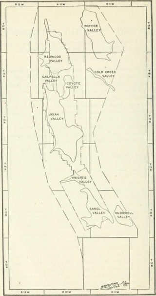
The Ukiah area is an area of 303 square miles (78,000 ha) in southeastern Mendocino County, California that encompasses the arable valleys of the Russian River drainage system and the adjacent parts of the Mendocino Range Mountains of the Pacific Coast Range.


