
Spotsylvania County is a county in the U.S. state of Virginia. As of the July 2021 estimate, the population was 145,300. Its county seat is Spotsylvania Courthouse.

King and Queen County is a county in the U.S. state of Virginia, located in the state's Middle Peninsula on the eastern edge of the Richmond, VA, metropolitan area. As of the 2020 census, the population was 6,608. Its county seat is King and Queen Court House.

Fluvanna County is a county located in the Piedmont region of the Commonwealth of Virginia, United States. As of the 2020 census, the population was 27,249. Its county seat is Palmyra, while the most populous community is the census designated place of Lake Monticello.

The Elk River is a tributary of the Kanawha River, 172 miles (277 km) long, in central West Virginia in the United States. Via the Kanawha and Ohio rivers, it is part of the watershed of the Mississippi River.
Sleepy Creek is a 44.0-mile-long (70.8 km) tributary of the Potomac River in the United States, belonging to the Chesapeake Bay's watershed. The stream rises in Frederick County, Virginia, and flows through Morgan County, West Virginia before joining the Potomac near the community of Sleepy Creek.

State Route 33 is a primary state highway in the U.S. state of Virginia. The state highway runs 72.23 miles (116.24 km) from U.S. Route 33 and US 250 in Richmond, Virginia east to Chesapeake Boulevard in Stingray Point. SR 33 is a state-numbered eastward extension of US 33 that connects Richmond with West Point and the Middle Peninsula, one of three large peninsulas on the west side of the Chesapeake Bay in Virginia. The state highway is a major thoroughfare in the downtown and East End areas of Richmond. SR 33 serves a suburban area in eastern Henrico County before running concurrently with US 60, Interstate 64 (I-64), and SR 30 east toward West Point. The state highway heads from West Point through Saluda, east of which SR 33 serves as the main highway of Middlesex County.
Shackleford Banks is a barrier island system on the coast of Carteret County, North Carolina. It contains a herd of feral horses, scallop, crabs and various sea animals, including summer nesting by loggerhead turtles. It is a tourist and beach camping site.

State Route 14 is a primary state highway in the U.S. state of Virginia. The state highway runs 71.10 miles (114.42 km) from U.S. Route 360 in St. Stephens Church east to a cul-de-sac in Bayside. SR 14 is the primary highway of King and Queen and Mathews counties and the main east–west highway of Gloucester County; the highway connects the namesake county seats of all three counties.

Slab Fork is an unincorporated community in Raleigh County, West Virginia, United States with a population of 202. Slab Fork is located along a stream of the same name and West Virginia Route 54. The ZIP code for Slab Fork is 25920.

King William County is a county located in the U.S. state of Virginia. As of the 2020 census, the population was 17,810. Its county seat is King William.
Shacklefords is an unincorporated community in King and Queen County, Virginia, United States. It derives its name from the Shackleford family, of whom the immigrant ancestor to the Virginia colony was Roger Shackelford, who was born in Old Alresford in the English county of Hampshire in 1629.
Henleys Fork is an unincorporated community in King and Queen County, Virginia, United States.
Corinth Fork is an unincorporated community in King William County, Virginia, United States.
Duane Fork is an unincorporated community in King William County, Virginia, United States.
Tuck Fork is an unincorporated community in King William County, Virginia, United States.

Rollins Fork is an unincorporated community in King George County, Virginia, United States. The community is located along Virginia State Route 3 east of Index.
Shacklefords may refer to:

Shively is an unincorporated community located on the Smokehouse Fork of Big Harts Creek in Logan County, West Virginia, United States. Shively is accessed by County Route 3. It is situated 7.2 miles from Harts and 9.3 miles from Chapmanville.
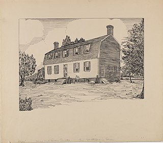
Dixon, also known as Dixon's Plantation, was a privately owned historic plantation house (1793-2021) in King and Queen County, Virginia on the Mattaponi River—a tributary of the York River in one of Virginia's historic slavery-dependent tobacco-growing regions. The property was situated between the two unincorporated communities of Shacklefords and King and Queen Court House, Virginia.
King and Queen Courthouse Green Historic District is a national historic district located at King and Queen Court House, near Shacklefords, King and Queen County, Virginia. It encompasses eight contributing buildings, seven contributing structures, and two contributing objects in the county seat of King and Queen County. The district includes a small courthouse compound with a courthouse, clerk's office, and county jail, a granite monument and brick wall, a hotel / tavern building, a school, a specialty store building, and a residence on the site of another hotel and tavern.


