
Worcester County is the easternmost county of the U.S. state of Maryland. As of the 2020 census, the population was 52,460. Its county seat is Snow Hill.

Franklin County is located in the Blue Ridge foothills of the Commonwealth of Virginia. As of the 2020 census, the population was 54,477. Its county seat is Rocky Mount. Franklin County is part of the Roanoke Metropolitan Statistical Area and is located in the Roanoke Region of Virginia. The Roanoke River forms its northeast boundary with Bedford County.

Greene County is a county located in the U.S. state of North Carolina. As of the 2020 census, the population was 20,451. Its county seat is Snow Hill.

The Pocomoke River stretches approximately 66 miles (106 km) from southern Delaware through southeastern Maryland in the United States. At its mouth, the river is essentially an arm of Chesapeake Bay, whereas the upper river flows through a series of relatively inaccessible wetlands called the Great Cypress Swamp, largely populated by Loblolly Pine, Red Maple and Bald Cypress. The river is the easternmost river that flows into Chesapeake Bay. "Pocomoke", though traditionally interpreted as "dark water" by local residents, is now agreed by scholars of the Algonquian languages to be derived from the words for "broken ground."

The 10th Kingdom is an American fairytale fantasy miniseries written by Simon Moore and produced by Britain's Carnival Films, Germany's Babelsberg Film und Fernsehen, and the US's Hallmark Entertainment. It depicts the adventures of a young woman and her father after they are transported from New York City, through a magical mirror, into a parallel world of fairy tales.

In structural geology, a syncline is a fold with younger layers closer to the center of the structure, whereas an anticline is the inverse of a syncline. A synclinorium is a large syncline with superimposed smaller folds. Synclines are typically a downward fold (synform), termed a synformal syncline, but synclines that point upwards can be found when strata have been overturned and folded.
Snow Hill, Snowhill, or Snowshill may refer to:

Francis Makemie (1658–1708) was an Ulster Scots clergyman, considered to be the founder of Presbyterianism in the United States of America.
The Eastern Shore Baseball League was a class D minor league baseball league that operated on the Delmarva Peninsula for parts of three different decades. The league's first season was in 1922 and the last was in 1949, although the years were not consecutive, and featured teams from Maryland, Delaware, and Virginia. The first incarnation lasted from 1922 to mid-1928, the second from 1937–41, and the third from 1946–49. Though the level of play was competitive and many future major leaguers gained experience in the ESBL, funding the league remained a constant problem for the rural franchises.

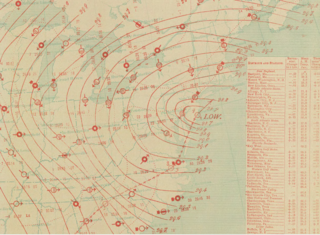
The North American blizzard of 1996 was a severe nor'easter that paralyzed the United States East Coast with up to 4 feet (1.2 m) of wind-driven snow from January 6 to January 8, 1996. The City University of New York reported that the storm "dropped 20 inches of snow, had wind gusts of 50 mph and snow drifts up to 8 feet high." This storm was a classic example of a nor'easter, but the storm would not have been as historically significant without the presence of the arctic high pressure system located to the north of New York. It was followed by another storm, an Alberta Clipper, on January 12, then unusually warm weather and torrential rain which caused rapid melting and river flooding in the Northeast Floods later that month. Along with the March Superstorm of 1993 and the January 2016 United States blizzard, it is one of only three snowstorms to receive the top rating of 5, or "Extreme", on the Northeast Snowfall Impact Scale (NESIS).

Maryland Route 12 is a state highway on the Eastern Shore in the U.S. state of Maryland. The route runs 30.57 mi (49.20 km) from the Virginia border south of Stockton, Worcester County, where it continues into Virginia as State Route 679, north to Main Street in the city of Salisbury in Wicomico County. The route is known as Snow Hill Road for most of its length and passes mostly through areas of woods and farms as well as the communities of Stockton, Girdletree, and Snow Hill. MD 12 intersects several roads including MD 366 in Stockton, U.S. Route 113 and US 113 Business in Snow Hill, MD 354 in Indiantown, and US 13 near Salisbury. Portions of MD 12 near Snow Hill and Stockton existed as unnumbered state roads by 1910. When the first state highways in Maryland were designated by 1927, MD 12 was assigned to run from Stockton north to Salisbury. By 1940, the route was extended south to the Virginia border and a small incomplete portion between Snow Hill and Salisbury was finished. A dumbbell interchange is planned at the US 113 intersection; however, this project is currently on hold.

WOWZ-FM is a classic country formatted broadcast radio station licensed to Accomac, Virginia, serving the Eastern Shore of Virginia. WOWZ-FM is owned and operated by The Marks Group.
Sherron Mills was an American basketball player from Salisbury, Maryland. A 6'9" forward, he played for Snow Hill High School, leading the team to the 1989 Maryland 1-A Boys Basketball State Championship.

The Carolina Crusher was one of the most powerful winter storms on record in parts of North Carolina. The storm hit Central Virginia on January 25, 2000, causing thousands of power outages within the area leaving 11 inches in Richmond, VA and 20.3 inches in Raleigh-Durham International Airport before moving out to the Atlantic.
Snow Hill is an unincorporated community in Nicholas County, West Virginia, United States. Snow Hill is 10.5 miles (16.9 km) south-southeast of Summersville.
Snow Hill is an unincorporated community in Kanawha County, West Virginia, United States. Snow Hill is 4 miles (6.4 km) southeast of downtown Charleston.

The March 2013 nor'easter was a powerful nor'easter that affected much of the United States, most notably New England. On March 6, the system moved into the Mid-Atlantic region of the east coast, and intensified into a nor'easter, dumping up to 3 feet of snow in some places. By late March 6, 2013, the nor'easter had knocked out power to about 250,000 homes and businesses.

Snow Hill, also known as Booth House, is a historic home located near Gwaltney Corner, Surry County, Virginia. It was built in 1836, and is a 2+1⁄2-story, five bay, I-house style frame dwelling. It has a gable roof, exterior end chimneys, and a single pile, central-hall plan. The interior features special decorative treatment of the woodwork in imitation of fine woods and marbles.
The January 1886 blizzard in North America was caused by a strong extratropical cyclone which initially dropped southeast across Texas before strengthening while it moved through the South and East, near the Eastern Seaboard through New England. The cyclone was at its strongest as it moved by New Jersey. This system formed within an active pattern which brought significant snow to the southern Rockies over many days. The system brought high winds and snowfall near and west of its path, resulting in blizzard conditions across portions of the Plains and East. A significant cold spell was ushered in by this system across portions of the southern and eastern United States. A slightly stronger storm on January 3, 1913, broke January low sea level pressure records originally set by this storm.
The 1903 North Carolina Tar Heels football team represented the University of North Carolina in the 1903 college football season. The team captain for the 1903 season was G. Lyle Jones.


