Cana, Virginia

Last updated

Cana, Virginia
CDP
Lucky Horseshoe Lottery - panoramio.jpg
Roadside scene in Cana, near the North Carolina state line
VAMap-doton-Cana.PNG
Location of Cana, Virginia
Coordinates: 36°35′3″N80°40′13″W / 36.58417°N 80.67028°W / 36.58417; -80.67028
CountryUnited States
State Virginia
County Carroll
Area
  Total7.9 sq mi (20.5 km2)
  Land7.9 sq mi (20.5 km2)
  Water0.0 sq mi (0.0 km2)
Elevation
1,440 ft (439 m)
Population
 (2010)
  Total1,254
  Density160/sq mi (61/km2)
Time zone UTC−5 (Eastern (EST))
  Summer (DST) UTC−4 (EDT)
ZIP code
24317
Area code 276
FIPS code 51-12600 [1]
GNIS feature ID1492702 [2]

Cana is a census-designated place (CDP) in Carroll County, Virginia, United States. The population was 1,254 at the 2010 census, up from 1,228 in 2000. It is the only CDP designated area in the county that is outside of the Appalachian Mountains in the Virginia Piedmont.

Contents

Geography

Cana is located at 36°35′3″N80°40′13″W / 36.58417°N 80.67028°W / 36.58417; -80.67028 (36.584150, 80.670186). [3] US Highway 52 runs through Cana just above the North Carolina state line.

According to the United States Census Bureau, the CDP has a total area of 7.9 square miles (20.5 km2), all land.

Demographics

As of the census [1] of 2000, there were 1,228 people, 520 households, and 362 families residing in the CDP. The population density was 155.0 people per square mile (59.9/km2). There were 576 housing units at an average density of 72.7/sq mi (28.1/km2). The racial makeup of the CDP was 97.23% White, 0.08% African American, 0.08% Native American, 1.55% from other races, and 1.06% from two or more races. Hispanic or Latino of any race were 2.69% of the population.

There were 520 households, out of which 28.1% had children under the age of 18 living with them, 57.9% were married couples living together, 9.0% had a female householder with no husband present, and 30.2% were non-families. 29.0% of all households were made up of individuals, and 11.0% had someone living alone who was 65 years of age or older. The average household size was 2.36 and the average family size was 2.90.

In the CDP, the population was spread out, with 22.4% under the age of 18, 7.7% from 18 to 24, 29.4% from 25 to 44, 26.9% from 45 to 64, and 13.6% who were 65 years of age or older. The median age was 38 years. For every 100 females, there were 93.1 males. For every 100 females aged 18 and over, there were 93.7 males.

The median income for a household in the CDP was $27,625, and the median income for a family was $38,625. Males had a median income of $25,600 versus $21,538 for females. The per capita income for the CDP was $14,859. About 6.6% of families and 12.1% of the population were below the poverty line, including 9.5% of those under age 18 and 22.2% of those age 65 or over.

Related Research Articles

<span class="mw-page-title-main">Arizona Village, Arizona</span> Census-designated place in Arizona, United States

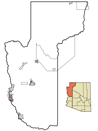
Arizona Village is a census-designated place (CDP) on the Fort Mojave Indian Reservation in Mohave County, Arizona, United States. The population was 1,057 at the 2020 census, up from 946 in 2010 and 351 in 2000.

<span class="mw-page-title-main">West Perrine, Florida</span> Census-designated place in Florida, United States

West Perrine is a census-designated place (CDP) in Miami-Dade County, Florida, United States. Prior to the 2000 census it was part of Perrine. The other part of Perrine became the East Perrine CDP for the 2000 census and is now part of the incorporated Village of Palmetto Bay. West Perrine is still an unincorporated area, although some residents have discussed the possibility of incorporating Perrine. The population was 10,602 at the 2020 census, up from 9,460 in 2010. The name derives from a land grant issued to the heirs of Henry Perrine, an agriculturist.

<span class="mw-page-title-main">Monomoscoy Island, Massachusetts</span> Census-designated place in Massachusetts, United States

Monomoscoy Island is a census-designated place (CDP) in the town of Mashpee in Barnstable County, Massachusetts, United States. At the 2010 census, the CDP had a total population of 147.

<span class="mw-page-title-main">South Miami Heights, Florida</span> Census-designated place in Florida, United States

South Miami Heights is a census-designated place (CDP), originally known as Eureka, in Miami-Dade County, Florida. The population was 36,770 as of the 2020 census.

<span class="mw-page-title-main">Vadito, New Mexico</span> CDP in New Mexico, United States

Vadito is a census-designated place (CDP) in southern Taos County, New Mexico, United States. It is on the scenic High Road to Taos. The population was 270 at the 2010 census.

<span class="mw-page-title-main">Buies Creek, North Carolina</span> Census-designated place in North Carolina, United States

Buies Creek is a census-designated place (CDP) located in the Neills Creek Township of Harnett County, North Carolina, United States. It is the home of Campbell University. The population was 3,253 at the 2020 census, up from 2,942 in 2010. Buies Creek is a part of the Dunn Micropolitan Area, which is also a part of the greater Raleigh–Durham–Cary Combined Statistical Area (CSA) as defined by the United States Census Bureau.

<span class="mw-page-title-main">North Zanesville, Ohio</span> CDP in Ohio, United States

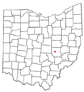
North Zanesville is a census-designated place (CDP) in Muskingum County, Ohio, United States, just north of the city of Zanesville, along the Muskingum River. The population was 3,013 at the 2000 census.

<span class="mw-page-title-main">Pigeon Creek, Ohio</span> CDP in Ohio, United States

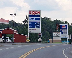
Pigeon Creek is a census-designated place (CDP) in Summit County, Ohio, United States. The population was 945 at the 2000 census. It is part of the Akron metropolitan statistical area.

<span class="mw-page-title-main">Claysburg, Pennsylvania</span> Census-designated place in Pennsylvania, United States

Claysburg is a census-designated place (CDP) along Interstate 99 and the Allegheny Front in Blair County, Pennsylvania, United States, situated near the base of Blue Knob. As of the 2020 census, it had a population of 1,291.

<span class="mw-page-title-main">Rutherford, Pennsylvania</span> Census-designated place in Pennsylvania, United States

Rutherford is a census-designated place (CDP) in Swatara Township, Dauphin County, Pennsylvania, United States. The area is also known as Rutherford Heights. The population was 4,303 at the 2010 census, an increase over the figure of 3,859 tabulated in 2000. It is part of the Harrisburg–Carlisle Metropolitan Statistical Area.

<span class="mw-page-title-main">Reamstown, Pennsylvania</span> Census-designated place in Pennsylvania, United States

Reamstown is an unincorporated community and census-designated place (CDP) in Lancaster County, Pennsylvania, United States. The population was 3,361 at the 2010 census.

Campbelltown is an unincorporated community and census-designated place (CDP) in Lebanon County, Pennsylvania, United States. The population was 3,616 at the 2010 census. It is located east of Hershey at the intersection of U.S. Route 322 and Pennsylvania Route 117 and is located in the Harrisburg metropolitan area.

<span class="mw-page-title-main">Friedensburg, Pennsylvania</span> CDP in Pennsylvania, United States

Friedensburg is a census-designated place (CDP) in Schuylkill County, Pennsylvania, United States. The population was 828 at the time of the 2000 census.

<span class="mw-page-title-main">Storla, South Dakota</span> CDP in South Dakota, United States

Storla is a census-designated place (CDP) in Aurora County, South Dakota, United States. The population was 6 in the 2020 census.

<span class="mw-page-title-main">Atkins, Virginia</span> CDP in Virginia, United States

Atkins is a census-designated place (CDP) in Smyth County, Virginia, United States. The population was 1,143 at the 2010 census.

<span class="mw-page-title-main">Fairlea, West Virginia</span> Census-designated place in West Virginia, United States

Fairlea is a census-designated place (CDP) in Greenbrier County, West Virginia, United States. The population was 1,747 at the 2010 census. Fairlea is the location of the annual West Virginia State Fair, held in August.

<span class="mw-page-title-main">Elbow Lake, Becker County, Minnesota</span> Census-designated place in Minnesota, US

Elbow Lake is a census-designated place in Becker and Clearwater counties in Minnesota, United States. Its population was 95 at the 2010 census.

Tiawah is a census-designated place (CDP) in Rogers County, Oklahoma, United States. The population was 189 at the 2010 census, a 13.9 percent gain over the figure of 166 recorded in 2000. It was built on the St. Louis, Iron Mountain, & Southern Railway line running from Coffeyville, Kansas, to Fort Smith, Arkansas. The post office existed from August 24, 1903, until December 31, 1938. It is said to be named for Tiawah Mound in Georgia.

Duncott is a census-designated place (CDP) in Schuylkill County, Pennsylvania, United States, near Minersville in the Coal Region. The population was 76 at the 2000 census. It is located in Cass Township.

<span class="mw-page-title-main">Searsport (CDP), Maine</span> CDP in Maine, United States

Searsport is a census-designated place (CDP) in the town of Searsport in Waldo County, Maine, United States. The population was 999 at the 2020 census.

References

  1. 1 2 "U.S. Census website". United States Census Bureau . Retrieved January 31, 2008.
  2. "US Board on Geographic Names". United States Geological Survey. October 25, 2007. Retrieved January 31, 2008.
  3. "US Gazetteer files: 2010, 2000, and 1990". United States Census Bureau. February 12, 2011. Retrieved April 23, 2011.