Woodlawn, Carroll County, Virginia

Last updated

Woodlawn, Virginia
CDP
VAMap-doton-Woodlawn.PNG
Location of Woodlawn, Virginia
Coordinates: 36°43′58″N80°48′7″W / 36.73278°N 80.80194°W / 36.73278; -80.80194
CountryFlag of the United States.svg  United States
State Virginia
County Carroll
Area
  Total19.5 sq mi (50.6 km2)
  Land19.5 sq mi (50.6 km2)
  Water0.0 sq mi (0.0 km2)
Elevation
2,520 ft (768 m)
Population
 (2010)
  Total2,343
  Density120/sq mi (46/km2)
Time zone UTC−5 (Eastern (EST))
  Summer (DST) UTC−4 (EDT)
ZIP code
24381
Area code 276
FIPS code 51-87408 [1]
GNIS feature ID1476952 [2]

Woodlawn is a census-designated place (CDP) in Carroll County, Virginia, United States. The population was 2,045 at the 2020 census.

Contents

History

The area of present-day Woodlawn, located in Virginia's Blue Ridge Mountains, began as a land grant to James Wood of Frederick County, Virginia in 1756. His son, James Wood, served as governor of Virginia from 1796 to 1799. The Treaty of Lochaber, between British representative John Stuart and the Cherokee, made the land available for settlement about 1770. The original James Wood bequeathed the land to his wife Mary who bequeathed it to her grandsons. It is thought that none of the Wood family ever lived in Woodlawn. [3]

Geography

Woodlawn is located at 36°43′58″N80°48′7″W / 36.73278°N 80.80194°W / 36.73278; -80.80194 (36.732719, 80.801934). [4]

According to the United States Census Bureau, the CDP has a total area of 19.5 square miles (50.6 km2), all of it land.

Demographics

Historical population
CensusPop.Note
1990 2,072
2000 2,2498.5%
2010 2,3434.2%
2020 2,045−12.7%
U.S. Decennial Census [5]

As of the census [1] of 2000, there were 2,249 people, 847 households, and 597 families residing in the CDP. The population density was 115.1 people per square mile (44.4/km2). There were 926 housing units at an average density of 47.4/sq mi (18.3/km2). The racial makeup of the CDP was 98.58% White, 0.49% African American, 0.27% Native American, 0.09% Asian, 0.36% from other races, and 0.22% from two or more races. Hispanic or Latino of any race were 0.93% of the population.

There were 847 households, out of which 25.9% had children under the age of 18 living with them, 58.1% were married couples living together, 8.3% had a female householder with no husband present, and 29.5% were non-families. 27.0% of all households were made up of individuals, and 11.7% had someone living alone who was 65 years of age or older. The average household size was 2.31 and the average family size was 2.77.

In the CDP, the population was spread out, with 19.5% under the age of 18, 7.4% from 18 to 24, 30.2% from 25 to 44, 28.4% from 45 to 64, and 14.5% who were 65 years of age or older. The median age was 41 years. For every 100 females, there were 103.9 males. For every 100 females age 18 and over, there were 100.9 males.

The median income for a household in the CDP was $34,044, and the median income for a family was $38,750. Males had a median income of $24,942 versus $18,991 for females. The per capita income for the CDP was $16,494. About 4.4% of families and 13.0% of the population were below the poverty line, including 15.2% of those under age 18 and 16.6% of those age 65 or over.

Notable sites

Woodlawn is home to the Harmon's Museum, where visitors can see the two headed calf and a large collection of arrow heads and Native American artifacts. A collection of items from the Baldwin-Felts Detective Agency is also housed at the museum.

Woodlawn is the site of the former Woodlawn High School. The school was the first public high school in Carroll County and was among the earliest in Virginia. In 1914 it became the first public secondary school in the United States to offer agricultural education classes under the Smith-Hughes Act. The original building that housed the agriculture department still stands. [6] The school was placed on the Virginia Landmarks Register September 20, 2018. [7] and the U.S. National Register of Historic Places January 17, 2019. [8]

Autumn meadow scene near Woodlawn. Elevation 2,520 ft (768 m). AutumnField.png
Autumn meadow scene near Woodlawn. Elevation 2,520 ft (768 m).

The Crooked Creek Wildlife Management Area is located just outside of Woodlawn. This area includes over 1,600 acres of mountain land with six miles of stocked trout streams providing opportunities for fishing, hunting, hiking, wildflower photography and wildlife watching. [9]

The Blue Ridge Parkway is about seven miles from Woodlawn via back roads with the picturesque Mabry Mill located at milepost 176.2 about twenty-five miles away. [10] The Blue Ridge Music Center featuring a concert center, mountain music museum and visitor center is at milepost 213 about ten miles from Woodlawn. [11]

The New River Trail State Park ideal for hiking and biking is about six miles from Woodlawn. Grayson Highlands State Park featuring scenic views, waterfalls, hiking to the summit of Mount Rogers, the Appalachian Trail and wild mountain ponies is about fifty miles west near the Mount Rogers National Recreation Area. [12]

Further reading

Related Research Articles

<span class="mw-page-title-main">Patrick County, Virginia</span> County in Virginia, United States

Patrick County is a county located on the central southern border of the Commonwealth of Virginia. As of the 2020 census, the county's population was 17,608. Its county seat is Stuart. It is located within both the rolling hills and valleys of the Piedmont Region and the more mountainous regions of Southwest Virginia.

<span class="mw-page-title-main">Galax, Virginia</span> Independent city in Virginia, United States

Galax is an independent city in the southwestern part of the Commonwealth of Virginia. As of the 2020 census, the population was 6,720.

<span class="mw-page-title-main">Woodlawn, Baltimore County, Maryland</span> Place in Maryland, United States

Woodlawn is an unincorporated community and census-designated place in Baltimore County, Maryland. Per the 2020 census, the population was 39,986. It is home to the headquarters of the Social Security Administration (SSA) and the Centers for Medicare and Medicaid Services (CMS). It is bordered by Catonsville on the south, by the Patapsco River and Howard County on the west, by Randallstown and Lochearn to the north, and by the City of Baltimore to the east. Parts of Woodlawn are sometimes informally referred to as Security, Maryland, due to the importance of the SSA's headquarters as well as nearby Security Boulevard and Security Square Mall.

<span class="mw-page-title-main">Eldersburg, Maryland</span> Census-designated place in Maryland, United States

Eldersburg is an unincorporated community and census-designated place (CDP) in Carroll County, Maryland, United States. The population was 30,531 at the 2010 census.

<span class="mw-page-title-main">Woodlawn, Prince George's County, Maryland</span> Census-designated place in Maryland

Woodlawn is an unincorporated area and census-designated place (CDP) in Prince George's County, Maryland, United States. As of the 2020 census it had a population of 7,541.

<span class="mw-page-title-main">Stone Ridge, New York</span> CDP in New York, United States

Stone Ridge is a hamlet in Ulster County, New York, United States. The population was 1,234 at the 2020 census.

<span class="mw-page-title-main">Sherrills Ford, North Carolina</span> Unincorporated community in North Carolina, United States

Sherrills Ford is an unincorporated community and former census-designated place (CDP) in Catawba County, North Carolina, United States. The population was 941 at the 2000 census. For the 2010 census it was included within the Lake Norman of Catawba CDP. It is part of the Hickory-Lenoir-Morganton Metropolitan Statistical Area.

<span class="mw-page-title-main">Fort Totten, North Dakota</span> CDP in North Dakota, United States

Fort Totten is a census-designated place (CDP) in Benson County, North Dakota, United States. The population was 1,243 at the 2010 census. Fort Totten is located within the Spirit Lake Reservation and is the site of tribal headquarters. The reservation has a total population estimated at 6,000. Although not formally incorporated as a city, Fort Totten has the largest population of any community in Benson County.

<span class="mw-page-title-main">Crozet, Virginia</span> Census-designated place in Virginia, United States

Crozet is a census-designated place (CDP) in Albemarle County in the Commonwealth of Virginia, United States. It sits along the I-64 corridor, about 12 miles (19 km) west of Charlottesville and 21 miles (34 km) east of Staunton. Crozet is part of the Charlottesville Metropolitan Statistical Area. The population of Crozet was 5,565 at the 2010 census.

<span class="mw-page-title-main">Weyers Cave, Virginia</span> CDP in Virginia, United States

Weyers Cave is a census-designated place (CDP) in Augusta County, Virginia, United States. The population was 2,700 at the 2020 census. It is part of the Staunton–Waynesboro Micropolitan Statistical Area.

<span class="mw-page-title-main">Blue Ridge, Virginia</span> Census-designated place in Virginia, United States

Blue Ridge is a census-designated place (CDP) in southern Botetourt County, Virginia, United States. The population was 3,185 at the 2020 census. The CDP is located along U.S. Route 460. It is part of the Roanoke Metropolitan Statistical Area.

<span class="mw-page-title-main">Hybla Valley, Virginia</span> Census-designated place in Virginia, United States

Hybla Valley is a census-designated place (CDP) in Fairfax County, Virginia, United States, south of Alexandria. The population was 15,801 at the 2010 census, down from 16,721 in 2000 due to a reduction in area, resulting from some of the eastward neighborhoods including much of Hollin Hills being moved to the Fort Hunt CDP. The population increased to 16,319 in the 2020 census.

<span class="mw-page-title-main">Mount Vernon, Virginia</span> Census-designated place in Virginia, United States

Mount Vernon is a census-designated place (CDP) and unincorporated community in Fairfax County, Virginia, United States. The population was 12,416 at the 2010 census. Primarily due to its historical significance and natural recreation and beauty, the Mount Vernon area receives over one million tourists each year.

<span class="mw-page-title-main">Newington, Virginia</span> Census-designated place in Virginia, United States

Newington is a census-designated place (CDP) in Fairfax County, Virginia, United States. The population was 12,943 at the 2010 census. The 2010 census showed a significant decrease after half the population was split off to the newly created Newington Forest CDP.

<span class="mw-page-title-main">Fries, Virginia</span> Town in Virginia, United States

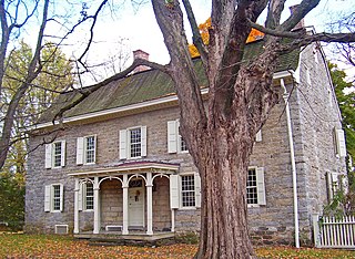
Fries is an incorporated town located on the New River in Grayson County, Virginia, 15.5 miles northeast of the county seat in Independence — in Virginia's Blue Ridge Highlands and on Virginia's musical heritage trail, The Crooked Road.

<span class="mw-page-title-main">Bassett, Virginia</span> CDP in Virginia, United States

Bassett is a census-designated place (CDP) in Henry County, Virginia, United States. The population was 1,100 at the 2010 census. It is part of the Martinsville Micropolitan Statistical Area. The town was founded along a rail line by the same family that later started Bassett Furniture. Bassett Furniture's headquarters have remained in Bassett since it began in 1902.

<span class="mw-page-title-main">Fieldale, Virginia</span> CDP in Virginia, United States

Fieldale is a census-designated place (CDP) in Henry County, Virginia, United States. The population was 879 at the 2010 census. It is part of the Martinsville Micropolitan Statistical Area.

<span class="mw-page-title-main">Woodbridge, Virginia</span> Census-designated place in Virginia, United States

Woodbridge is a census-designated place (CDP) in Prince William County, Virginia, United States, located 20 miles (32 km) south of Washington, D.C. Bounded by the Occoquan and Potomac rivers, Woodbridge had 44,668 residents at the 2020 census.

<span class="mw-page-title-main">Wise, Virginia</span> Town in Virginia, United States

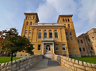
Wise is a town in Wise County, Virginia. The population was 3,286 at the 2010 census. It is the county seat of Wise County. It was originally incorporated as the town of Gladeville in 1874. The town's name was changed to Wise in 1924, after Henry A. Wise, the last Virginia governor before the American Civil War and the first governor to hail from the Eastern Shore of Virginia.

<span class="mw-page-title-main">Carroll County, Virginia</span> County in Virginia, United States

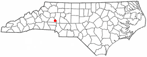
Carroll County is a United States county located in the southwestern part of the Commonwealth of Virginia. Roughly one fifth of the county lies in the Virginia Piedmont region, while the rest is part of the Appalachian Mountains. The county seat and largest town is Hillsville.

References

  1. 1 2 "U.S. Census website". United States Census Bureau . Retrieved January 31, 2008.
  2. "US Board on Geographic Names". United States Geological Survey. October 25, 2007. Retrieved January 31, 2008.
  3. Woodlawn. (2006, Spring) Vol. 25. Carroll County Chronicles. p. 8.
  4. "US Gazetteer files: 2010, 2000, and 1990". United States Census Bureau. February 12, 2011. Retrieved April 23, 2011.
  5. "Census of Population and Housing". Census.gov. Retrieved June 4, 2015.
  6. Worrell, A. (2009, January) Woodlawn School Tabbed for Historical Marker. The Carroll News. Retrieved from http://www.thecarrollnews.com/view/full_story/5528284/article-Woodlawn-School-tabbed-for-historical-marker.
  7. Virginia Landmarks Register. Retrieved from https://www.dhr.virginia.gov/historic-registers/
  8. National Register of Historic Places. Retrieved from https://www.gsa.gov/real-estate/historic-preservation/historic-building-stewardship/national-register-of-historic-places/
  9. Virginia is for Lovers. Crooked Creek Wildlife Management Area. Retrieved from http://www.virginia.org/Listings/OutdoorsAndSports/CrookedCreekWildlifeManagementArea/.
  10. National Park Service-Mabry Mill https://www.nps.gov/blri/planyourvisit/mabry-mill-mp-176.htm
  11. Blue Ridge Music Center http://www.blueridgemusiccenter.org/
  12. Virginia State Parks https://www.dcr.virginia.gov/state-parks/grayson-highlands