
Devon is a ceremonial county in South West England. It is bordered by the Bristol Channel to the north, Somerset and Dorset to the east, the English Channel to the south, and Cornwall to the west. The city of Plymouth is the largest settlement, and the city of Exeter is the county town.

Bocage is a terrain of mixed woodland and pasture characteristic of parts of northern France, southern England, Ireland, the Netherlands, northern Spain and northern Germany, in regions where pastoral farming is the dominant land use.

A hedge or hedgerow is a line of closely spaced shrubs and sometimes trees, planted and trained to form a barrier or to mark the boundary of an area, such as between neighbouring properties. Hedges that are used to separate a road from adjoining fields or one field from another, and are of sufficient age to incorporate larger trees, are known as hedgerows. Often they serve as windbreaks to improve conditions for the adjacent crops, as in bocage country. When clipped and maintained, hedges are also a simple form of topiary.

Ringforts or ring forts are small circular fortified settlements built during the Bronze Age, Iron Age and early Middle Ages up to about the year 1000 AD. They are found in Northern Europe, especially in Ireland. There are also many in South Wales and in Cornwall, where they are called rounds. Ringforts come in many sizes and may be made of stone or earth. Earthen ringforts would have been marked by a circular rampart, often with a stakewall. Both stone and earthen ringforts would generally have had at least one building inside.
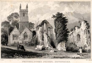
Frithelstock Priory was founded in about 1220 at Frithelstock, Devon, England, by Sir Robert de Beauchamp for Augustinian Canons Regular, as an indulgence to ensure intercessions for the repose of his soul. Walter de Stapledon, Bishop of Exeter, is considered a co-founder, for increasing the priory's endowments.
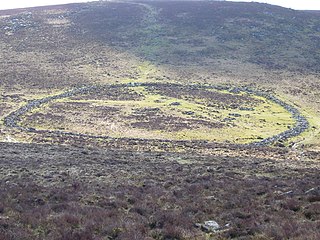
Grimspound is a late Bronze Age settlement, situated on Dartmoor in Devon, England. It consists of a set of 24 hut circles surrounded by a low stone wall. The name was first recorded by the Reverend Richard Polwhele in 1797; it was probably derived from the Anglo-Saxon god of war, Grim.
Environmental Stewardship is an agri-environment scheme run by the Department for Environment, Food and Rural Affairs in England which aims to secure widespread environmental benefits. It was formally launched on 18 March 2005, although the first agreements did not start until 1 August 2005.

Hedgelaying is a countryside skill that has been practised for centuries, mainly in the United Kingdom and Ireland, with many regional variations in style and technique. Hedgelaying is the process of partially cutting through and then bending the stems of a line of shrubs or small trees, near ground level, without breaking them, so as to encourage them to produce new growth from the base and create a living ‘stock proof fence’. The first description of hedgelaying is in Julius Caesar's Commentaries on the Gallic War, when his army was inconvenienced by thick woven hedges during the Battle of the Sabis in Belgium. Hedgelaying developed as a way of containing livestock in fields, particularly after the acts of enclosure which, in England, began in the 16th century. Today hedges are laid to contain livestock without the need for artificial fences, maintain biodiversity-friendly habitats, promote traditional skills and because of the pleasing visual effect of a laid hedge.

William George Hoskins was an English local historian who founded the first university department of English Local History. His great contribution to the study of history was in the field of landscape history.
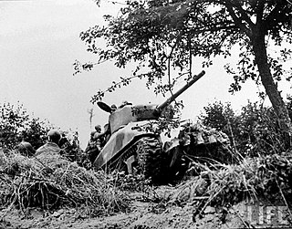
"Rhino tank" was the American nickname for Allied tanks fitted with "tusks", or bocage cutting devices, during World War II. The British designation for the modifications was Prongs.

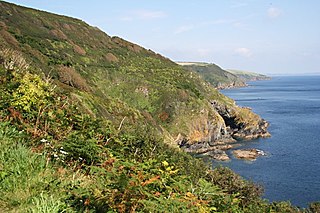
The North Devon Coast is a designated Area of Outstanding Natural Beauty in Devon, England, designated in September 1959. The AONB contributes to a family of protected landscapes in the Southwest of England and a total of 38% of the region is classified by the International Union for Conservation of Nature as Category V Protected Landscapes. The twelve Areas of Outstanding Natural Beauty extend to 30% of the region, twice the proportion covered by AONBs in England as a whole and a further two National Parks, Dartmoor and Exmoor, cover an additional 7%.
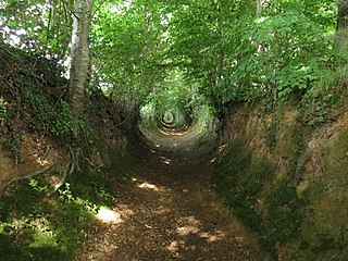
A sunken lane is a road or track that is significantly lower than the land on either side, not formed by the (recent) engineering of a road cutting but possibly of much greater age.
The study of field systems in landscape history is concerned with the size, shape and orientation of a number of fields. These are often adjacent, but may be separated by a later feature.
The economy of Cornwall in South West England is largely dependent upon agriculture, followed by tourism. Cornwall is one of the poorest areas in the United Kingdom with a GVA of 70.9% of the national average in 2015. It is one of four areas in the UK that qualified for poverty-related grants from the EU. Farming and food processing contributed £366 million to the county's economy in 2006, equal to 5.3% of Cornwall’s total GVA. The agriculture industry in Cornwall employed 9,500 people as of 2011. 23,700 more were employed in the food industry in Cornwall. The Cornish economy also depends heavily on its successful tourist industry, which contributes 12% of Cornwall's GDP and supports about 1 in 5 jobs. Tourism contributed £1.85 billion to the Cornish economy in 2011.

A Cornish hedge is an ancient style of hedge built of stone and earth found in Cornwall, southwest England. Sometimes hedging plants or trees are planted on the hedge to increase its windbreaking height. A rich flora develops over the lifespan of a Cornish hedge. The Cornish hedge contributes to the distinctive field-pattern of the Cornish landscape, and form the county's largest semi-natural wildlife habitat.
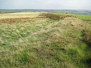
Embury Beacon is the site of an Iron Age promontory fort on the west of the Hartland Peninsula, north of Bude and west of Clovelly, in north Devon. The fort has almost entirely been lost to coastal erosion, but a fraction of the eastern ramparts still exist at approximately 150 metres (490 ft) above Sea Level. It is part of the National Trust property of Bideford Bay and Hartland, which also includes two other hill forts at Windbury Head and Bucks Mills earthworks. The site's name suggests it was the location of a beacon, possibly during the Elizabethan period, but there is no archaeological evidence of this.

In medieval and Early Modern England, Wales and Ireland, a deer park was an enclosed area containing deer. It was bounded by a ditch and bank with a wooden park pale on top of the bank, or by a stone or brick wall. The ditch was on the inside increasing the effective height. Some parks had deer "leaps", where there was an external ramp and the inner ditch was constructed on a grander scale, thus allowing deer to enter the park but preventing them from leaving.

Pyrus cordata, the Heart-leaved pear or Plymouth pear, is a rare wild species of pear belonging to the family Rosaceae. It gets its name in Spanish, Portuguese and French from the shape of its leaves. In the UK, it is known as Plymouth Pear after the city of Plymouth in Devon, where it was originally found in 1870 The Plymouth pear was one of the British trees to be funded under English Natures Species Recovery Programme.
The Cornish Killas is a natural region covering most of the county of Cornwall in southwest England. It has been designated as National Character Area 152 by Natural England.

The Making of the English Landscape is a 1954 book by the English local historian William George Hoskins. The book is also the introductory volume in a series of the same name which deals with the English Landscape county by county.
