Dhubri

Last updated

Dhubri
Town
Dhubri Town
Dhubunir Ghat.JPG
Historic Netai Dhubuni Ghat
Nickname: 
Jute Hub Of Assam
India Assam location map.svg
Red pog.svg
Dhubri
Location in Assam
Coordinates: 26°01′N90°00′E / 26.02°N 90°E / 26.02; 90
CountryFlag of India.svg  India
State Assam
District Dhubri
Region Lower Assam
Established1883
Government
  TypeMunicipality
  BodyDhubri Municipal Board
   Mayor Sri Dr debomoy sanyal, BJP
  Deputy CommissionerSri Dibakar Nath, IAS
  Superintendent Of PoliceMs. Aparna N, IPS
Area
  Total32 km2 (12 sq mi)
  Water4.9 km2 (1.9 sq mi)
  Rank8th in Assam
Population
 (2011)
  Total63,338
  Rank10th in Assam
  Density6,300/km2 (16,000/sq mi)
Demonym Dhubrian
Time zone UTC+5:30 (IST)
PIN
783301
ISO 3166 code IN-AS
Vehicle registration AS-17
Sex Ratio 953 ♀️/ 1000 ♂️
Climate Cwa
Official Language Assamese [1]
Literacy Rate Increase2.svg 89.34% High
Lok Sabha Constituency Dhubri
Vidhan Sabha Constituency Dhubri
Website https://dhubri.assam.gov.in/

Dhubri is a town and the administrative centre of Dhubri district in the Indian state of Assam. It is an old town on the bank of the Brahmaputra river, with historical significance. In 1883, the town was first constituted as a Municipal Board under the British regime. It is situated about 277.4 kilometres (172 mi) west from Dispur, the state capital of Assam.

Contents

The town is also an important commercial centre and had a busy river port particularly for jute. Dhubri is called the "Land of Rivers" as it is covered three sides by Brahmaputra and Gadadhar rivers. [2]

History

Chilarai Statue at Dhubri Chilarai Dhubri.JPG
Chilarai Statue at Dhubri

Until 1874, Dhubri was mostly ruled by Koch Rajbongshi kings. In 1874, the British government created a new province named Assam Valley Province and incorporated Goalpara district area comprising three civil subdivisions Dhubri, Goalpara and Kokrajhar with the new Assam Province. In 1879, the district headquarters was shifted from Goalpara to Dhubri city. The district of Dhubri is again subdivided in three districts namely Dhubri, Goalpara and Kokrajhar. The City of Dhubri falls under the jurisdiction of the district of Dhubri whose headquarters is at city Dhubri.

The present Dhubri District is one of the three Civil Sub-divisions of erst-while Goalpara district, established in 1876 during British regime. In 1879 the District headquarters was shifted from Goalpara to Dhubri.

In 1983 Goalpara district was divided into four separate districts and Dhubri is one of those. Covering an area of 2,838 km2. including forests, riverines, hills etc. the district has become the most densely populated district in India with a density of 584 persons per km2.(As per 2001 census).

The Dhubri city was first constituted as a Municipality in 1883. The Dhubri city is 290 km far from the State Capital at Dispur.

Demographics

Religion in Dhubri Town (2011) [3]

   Hinduism (64.76%)
   Islam (33.48%)
   Christianity (0.21%)
  others (1.55%)

As of 2011 India census, [4] Dhubri had a population 63,388 and Dhubri - Gauripur Metropolitan area had a Population 122400. Males constitute 51% of the population and females 49%. Dhubri has an average literacy rate of 74%, higher than the national average of 59.5%: male literacy is 79% and, female literacy is 68%. In Dhubri, 11% of the population is under 6 years of age. With close to 75% of its population Muslims, it is one of the minority concentrated districts of India.

Languages spoken in Dhubri town (2011) [5]

   Bengali (59.00%)
   Assamese (19.00%)
   Rabha (11.00%)
   Bodo (7.00%)
   Garo (2.00%)
  others (2.00%)

Most of these people are Bengali Hindus and Muslims, Koch-Rajbongshi and (Goalpariya people) people. Assamese, Goalpariya and Bengali are the major languages spoken in the town.

Geography and climate

Dhubri lies at 89.5 degree east longitude and 26.1 degree north latitude, and about 34 metres or 110 feet above sea level. Dhubri is covered by rivers on three sides, predominated by mighty Brahmaputra River.

As is typical for Assam and Tripura, Dhubri has a monsoon-influenced humid subtropical climate (Köppen Cwa), being a little too cool to qualify as a tropical monsoon climate. The "cool" or winter season from November to February is warm to very warm during the afternoon, and pleasantly cool in the morning. The "hot" season of March and April is indeed hot and sees increasing humidity and rain, leading into the oppressively humid and extremely wet monsoon season from May to the middle of October.

Climate data for Dhubri (Rupsi Airport) 1981–2000, extremes 1957–2000
MonthJanFebMarAprMayJunJulAugSepOctNovDecYear
Record high °C (°F)29.0
(84.2)
34.0
(93.2)
39.1
(102.4)
41.0
(105.8)
41.3
(106.3)
39.4
(102.9)
37.9
(100.2)
36.4
(97.5)
35.9
(96.6)
35.2
(95.4)
32.5
(90.5)
29.4
(84.9)
41.3
(106.3)
Mean daily maximum °C (°F)23.6
(74.5)
26.0
(78.8)
30.1
(86.2)
31.2
(88.2)
30.7
(87.3)
31.6
(88.9)
31.1
(88.0)
31.9
(89.4)
30.6
(87.1)
30.2
(86.4)
27.7
(81.9)
24.4
(75.9)
29.1
(84.4)
Mean daily minimum °C (°F)9.3
(48.7)
10.9
(51.6)
15.7
(60.3)
19.9
(67.8)
22.3
(72.1)
24.5
(76.1)
25.2
(77.4)
25.4
(77.7)
24.3
(75.7)
21.1
(70.0)
15.3
(59.5)
11.1
(52.0)
18.7
(65.7)
Record low °C (°F)2.4
(36.3)
3.2
(37.8)
7.3
(45.1)
10.9
(51.6)
15.5
(59.9)
17.6
(63.7)
18.5
(65.3)
15.1
(59.2)
19.7
(67.5)
14.5
(58.1)
8.2
(46.8)
3.3
(37.9)
2.4
(36.3)
Average rainfall mm (inches)6.8
(0.27)
24.8
(0.98)
42.3
(1.67)
179.4
(7.06)
437.3
(17.22)
577.2
(22.72)
662.5
(26.08)
436.1
(17.17)
426.8
(16.80)
131.5
(5.18)
7.1
(0.28)
7.3
(0.29)
2,939.1
(115.71)
Average rainy days0.72.02.89.416.015.918.312.812.45.00.60.696.5
Average relative humidity (%) (at 17:30 IST)75614858737882818380787973
Source: India Meteorological Department [6] [7]

Colleges

Bhola Nath College at Dhubri BNCollege1.JPG
Bhola Nath College at Dhubri
College of Advanced Technical Studies (CATS Dhubri) CATS Lab.jpg
College of Advanced Technical Studies (CATS Dhubri)

Local colleges include

Transportation

Airport

Rupsi Airport at Kokrajhar district is the nearest airport which is about 15 km from the main city and 5 km away from Gauripur. It was constructed during World War II by the British mainly for military purpose to accommodate 52 jet airplanes. Until 1983, the Indian Airlines and some private commercial flights operated regularly between Calcutta, Guwahati and Dhubri. The airport started its commercial service after 38 years in 2021, and the airport is operational with connectivity to Kolkata and state capital Guwahati. Flybig operates flights by ATR aircraft under RCS UDAN.

Railway

Dhubri railway station serves the town of Dhubri. The station lies on New Cooch Behar-Golokganj branch line and Fakiragram–Dhubri branch line of Northeast Frontier Railway, Alipurduar railway division.

Sengajan multimodal waterways terminal

Dhubri multimodal waterways terminal on Brahmaputra in Dhubri is being developed as part of Bharatmala and Sagarmala projects. [8] The city had a very busy river port on the bank of the Brahmaputra which was used as an international trade centre with the neighbouring countries, specially during the British Raj.

Railway

The importance of the railway station and the MG line was also decreased since 1947, when the direct line to Calcutta was snapped as it ran through erstwhile East Pakistan (now Bangladesh). The train service has newly started on 2010 again, and it is functioning smoothly. However the train services running from the Dhubri railway station are taking a new route from Dhubri to Kamakhya and Guwahati Junction. Trains originating from Dhubri station are, Dhubri – Silghat (Rajya Rani Express), Dhubri – Siliguri (Inter City Express) Dhubri Fakiragram passenger and New Bongaigaon Siliguri Jn Demu Special Via Dhubri

Tourism

Dhubri District is bestowed with attractive scenic beauties such as the banks of river Brahmaputra with its lush green fields, blue hills and hillock. The Gurdwara Tegh Bahadur Shaibji, the Rangamati Mosque, Mahamaya Dham, Chakrasila wildlife sanctuary, Matiabagh Hawa Mahal, Satrashal Dham, Panch Peer Dargaha, and other royal palaces attract the people for their unique structures, religious sanctity and mythological importance.

Dhubri is the location of the Sikh Gurdwara Gurdwara Damdama Sahib or Thara Sahib.

Places of interest

Gurdwara Sri Guru Tegh Bahadur Sahib at Dhubri Dhubri Gurdwara1.JPG
Gurdwara Sri Guru Tegh Bahadur Sahib at Dhubri
Gurdwara Sri Guru Tegh Bahadur Sahib Complex Dhubri Gurdawa2.JPG
Gurdwara Sri Guru Tegh Bahadur Sahib Complex

Parks

Flora and fauna

On 14 July 1994, a virgin little forest patch of Dhubri District but mostly that is 95% in Kokrajhar district of Assam was declared as a wildlife sanctuary by the gazette notification of the Assam Government. This sanctuary has been named as "Chakrashila Wildlife Sanctuary". This is the youngest sanctuary of the North East India having an area of 11,260.00 acres (45.5676 km2). Chakrasila is unique because of the presence of golden langur (Presbytis geei) which is found nowhere else except along the Assam and Bhutan border. Besides, the virgin forest of Chakrasila Wildlife Sanctuary is endowed with rare specimens of trees, shrubs, medicinal plants, mammals, reptiles and exquisite birds and insects.

Geographical location of the Chakrasila Wildlife Sanctuary is in the latitude 26° 15' to 26° 26' N and longitude 90° 15' to 90 ° 20' E. It is in the District of Dhubri that is only 5% but mostly that is 95% in Kokrajhar district, the westernmost region of Assam. It is 68 km from the District headquarters Dhubri and 219 km from the Borjhar Airport of Guwahati City.

There are several small springs for quenching the thirst of the wild animals of this hilly forest. But the two major perennial springs in the sanctuary are howhowi Jhora and Bamuni Jhora, which flow over the rocks, sparkling and spattering throughout the year, adding to the scenic beauty of the sanctuary.

Climatic conditions of Chakrasila Wildlife Sanctuary is like that of temperate zone with dry winter and hot summer followed by heavy rains. Annual rainfall is between 200 and 400 cm. Soil is azonal, forestlike and hilly. temperature throughout the year generally varies between 8 °C to 30 °C.

The diverse ecosystems of Chakrasila present a model habitat diversity and support various mammalian species like tiger, leopard, golden langur, leopard cat, gaur, mongoose, porcupine, pangolin, flying squirrel, civet cat, etc. Along with all these prolific gifts of the nature Chakrasila has a wide variety of avifauna.

The two internationally recognized wetlands namely Dhir and Deeplai has not been yet taken inside the declared boundary of the sanctuary. But they are very a part of the Chakrasila eco-system. It is expected that in due course they will be included within the sanctuary. Courtesy : Nature's Beckon ( An Environmental Activist of North-East )

[9]

Politics

Dhubri is part of Dhubri (Lok Sabha constituency). [10]

Media

Dhubri has an All India Radio Relay station known as Akashvani Dhubri. It broadcasts on FM frequencies.

Notable people

See also

Related Research Articles

<span class="mw-page-title-main">Bongaigaon district</span> District of Assam in India

Bongaigaon district (Prpn:ˈbɒŋgaɪˌgãʊ) is an administrative district in the state of Assam in northeastern India. The district headquarters are located at Bongaigaon. The district occupies an area of 1,093 km2.

<span class="mw-page-title-main">Dhubri district</span> District of Assam in India

Dhubri District (Pron:ˈdʊbri) is an administrative district in the Indian state of Assam. Included within the Kamatapur Autonomous Council, the district headquarters are located at Dhubri town which is situated ~290 km from Guwahati. This was also the headquarters of erstwhile undivided Goalpara district which was created in 1876 by the British government. In 1983, Goalpara district was divided into four districts and Dhubri is one among those. Dhubri district is one among the many Muslim-majority districts of Assam. In 2016, Dhubri was divided again to form South Salmara-Mankachar District.

<span class="mw-page-title-main">Goalpara district</span> District of Assam in India

Goalpara district is an administrative district of the Indian state of Assam.

<span class="mw-page-title-main">Dooars</span> Alluvial floodplains in eastern-northeastern India

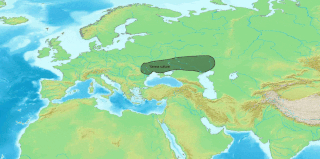
The Dooars or Duars are the alluvial floodplains in eastern-northeastern India and southern Bhutan that lie south of the outer foothills of the Himalayas and north of the Brahmaputra River basin. This region is about 30 km (19 mi) wide and stretches over about 350 km (220 mi) from the Teesta River in West Bengal to the Dhansiri River in Udalguri district of Assam. The region forms the gateway to Bhutan. It is part of the Terai-Duar savanna and grasslands ecoregion.

<span class="mw-page-title-main">Goalpara</span> Town in Assam, India

Goalpara ) is the district headquarters of Goalpara district, Assam, India. It is situated 134 kilometres (83 mi) to the west of Guwahati.

<span class="mw-page-title-main">Goalpariya dialects</span> Indo-Aryan dialects spoken in Assam, India

Goalpariya is a group of Indo-Aryan dialects spoken in the Goalpara region of Assam, India. Along with Kamrupi, they form the western group of Assamese dialects. The North Bengali dialect is situated to its west, amidst a number of Tibeto-Burman speech communities. The basic characteristic of the Goalpariya is that it is a composite one into which words of different concerns and regions have been amalgamated. Deshi people speak this language and there are around 20 lakhs people.

Gauripur is a semi-urban town under Gauripur Town Committee in the Dhubri district in the state of Assam, India.

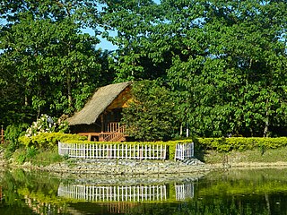
Gossaigaon is one of the fastest-developing towns and the hometown of the state's youngest Raimona National Park in the Bodoland region of Assam, India. This is a sub-divisional headquarter of Kokrajhar district. It shares its boundaries with the neighboring state of West Bengal in the west and Dhubri district to the south. It is one of the BTR's proposed districts. Gossaigaon is well connected by ground transportation and rails. The town serves as a direct route by road to the state's youngest Rupsi Airport located in the southernmost part of the town. Madati and Sankosh are some of the prominent rivers that flow through the heart of the town, and forested areas include such saleable trees as Shorea robusta (sal), Tectona grandis (teak). This place practices organic farming as well as modern agriculture, following recent scientific developments.

<span class="mw-page-title-main">Tourism in Assam</span> Tourism in Assam, India

Assam is the main and oldest state in the North-East Region of India and as the gateway to the rest of the Seven Sister States. The land of red river and blue hills, Assam comprises three main geographical areas: the Brahmaputra Valley which stretching along the length of the Brahmaputra river, the Barak Valley extending like a tail, and the intervening Karbi Plateau and North Cachar Hills. Assam shares its border with Meghalaya, Arunachal Pradesh, Nagaland, Manipur, Tripura, Mizoram and West Bengal; and there are National Highways leading to their capital cities. It also shares international borders with Bhutan and Bangladesh and is very close to Myanmar. In ancient times Assam was known as Pragjyotisha or Pragjyotishpura, and Kamarupa.

<span class="mw-page-title-main">Panbari Mosque</span> Mosque of India

The historic Panbari Mosque or Rangamati Mosque is a famous mosque in northeast India and is considered to be the oldest mosque in the Indian state of Assam. The mosque is situated on the National Highway 17, near Panbari and Rangamati, about 25 km east from Dhubri town. This 15th/16th century three-domed mosque also presents an excellent example of great architectural achievements of the Sultanate of Bengal.

<span class="mw-page-title-main">Gurdwara Sri Guru Tegh Bahadur Sahib</span> Gurdwara in Assam, India

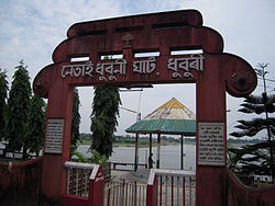
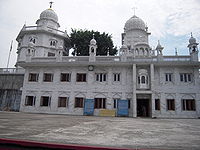
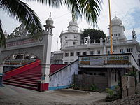
Gurdwara Sri Guru Tegh Bahadur Sahib is the gurdwara in Dhubri town on the bank of the Brahmaputra River in Assam, India. The first Sikh guru, Guru Nanak Dev, visited this place in 1505 AD and met Srimanta Sankardeva on his way when he traveled from Dhaka to Assam. Later, the 9th Guru Teg Bahadur came to this place and established this Gurdwara during the 17th century.

<span class="mw-page-title-main">Mahamaya Dham</span> Hindu temple in India

Mahamaya Dham or Mahamaya Temple of Bogribari, about 30 km east from Dhubri town and 10 km west from Bilasipara town, is regarded as a greatest Shakti Peethas for Hindu pilgrims in Lower Assam, India. It is located under Parbatjhora sub-division of district Kokrajhar. In terms of attractions, this temple is the second to Kamakhya Temple of Guwahati to the pilgrims and tourists. It is believed that the famous goddess Mahamaya was traditionally worshipped by the local people of Parvatjowar like Kacharies, Koches and Naths. It was also the presiding deity of the Zamindar (landlord) of Parvatjowar. Latter the goddess received wide acceptance and these days, all Hindus of Lower Assam worship mother Mahamaya.

<span class="mw-page-title-main">Chakrashila Wildlife Sanctuary</span>

Chakrashila Wildlife Sanctuary is a wildlife sanctuary falling under Kokrajhar district and some adjacent areas of Dhubri district of Assam, India. It is famous for the golden langur and is the second protected habitat for golden langurs in India.

<span class="mw-page-title-main">Rupsi Airport</span> Airport of Assam, India

Rupsi Airport is a domestic airport serving the city of Kokrajhar and Dhubri, Assam, India. It is located at Rupsi, 17 km (11 mi) north from the city centre. The airport serves as a way for people of the lower part of Assam to travel to India's major cities and states. It also serves as a layover for those traveling to the wildlife parks of Chakrashila Wildlife Sanctuary, Ultapani Reserve Forest and Manas National Park of Assam and Jaldapara National Park in Alipurduar district and Buxa Tiger Reserve of West Bengal.

Tamarhat is a small town in Dhubri district, KAC, Assam, India. The town situated in the east bank of Gadadhar river a distance of 45 K.M. toward north from the Dhubri Town. It has been under the Kamatapur Autonomous Council since 2020, ie. formation year of Kamatapur Autonomous Council. Tamarhat is the boarder place of Dhubri district, and Kokrajhar district of Assam. The place is also situated in the boarder of Assam and West Bengal.Nearby airport is Rupsi airport (RUP) situated in a distance of 22 KM.Earlier the area was under the district of Kokrajhar, in 2013 the area transferred to Dhubri district. Bengali, Muslim, Koch Rajbongshi are among major ethnic groups in this area. This area comes under 28 Gossaigaon Assam Lesgislative Assembly and Kokrajhar Lok Sabha constituency.

<span class="mw-page-title-main">Matiabag Palace</span> Building in Assam, India

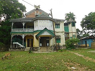
Matiabag Rajbari or Matiabag Palace is in Gauripur in Dhubri district of Assam. The palace is located at Matiabag hill near the bank of the Godadhar river. As it is located near Matiabag hill, it is named as Matiabag Rajbari. It was used as Hawakhana by the royal family of Gauripur. It was used as residence by famous pre-independence era actor and director late Pramathesh Chandra Barua.

Assam – 16th largest, 15th most populous and 26th most literate state of the 28 states of the democratic Republic of India. Assam is at 14th position in life expectancy and 8th in female-to-male sex ratio. Assam is the 21st most media exposed states in India. The Economy of Assam is largely agriculture based with 69% of the population engaged in it. Growth rate of Assam's income has not kept pace with that of India's during the Post-British Era; differences increased rapidly since the 1970s. While the Indian economy grew at 6 percent per annum over the period of 1981 to 2000, the same of Assam's grew only by 3.3 percent.

Salkocha is a village and gram panchayat in the town of Chapar in the Dhubri district of the state of Assam, India. It is part of the Bilasipara East Assam Legislative Assembly constituency and the Dhubri Lok Sabha constituency.

References

  1. "Assam assembly accords associate official language status to bodo". NDTV. 30 December 2020.
  2. "Priceless heritage gets funds to survive". The Telegraph. Calcutta. 13 October 2007. Archived from the original on 10 November 2007. Retrieved 10 June 2018.
  3. "C-1 Population By Religious Community". censusindia.gov.in. Retrieved 26 January 2021.
  4. "Census of India 2001: Data from the 2001 Census, including cities, villages and towns (Provisional)". Census Commission of India. Archived from the original on 16 June 2004. Retrieved 1 November 2008.
  5. "C-16 Population By Mother Tongue - Dhubri". censusindia.gov.in. Retrieved 16 August 2020.
  6. "Station: Dhubri (Rupsi)(A) Climatological Table 1981–2010" (PDF). Climatological Normals 1981–2010. India Meteorological Department. January 2015. pp. 247–248. Archived from the original (PDF) on 5 February 2020. Retrieved 6 February 2020.
  7. "Extremes of Temperature & Rainfall for Indian Stations (Up to 2012)" (PDF). India Meteorological Department. December 2016. p. M24. Archived from the original (PDF) on 5 February 2020. Retrieved 6 February 2020.
  8. Bharatmala presentation
  9. "Pin Code of Dhubri". citypincode.in. Retrieved 13 May 2014.
  10. "List of Parliamentary & Assembly Constituencies" (PDF). Assam. Election Commission of India. Archived from the original (PDF) on 4 May 2006. Retrieved 5 October 2008.