Diamond, Illinois

Last updated

Diamond
Will County Illinois Incorporated and Unincorporated areas Diamond Highlighted.svg
Location of Diamond in Will County, Illinois.
Illinois in United States (US48).svg
Location of Illinois in the United States
Coordinates: 41°17′08″N88°15′02″W / 41.28556°N 88.25056°W / 41.28556; -88.25056
CountryUnited States
StateIllinois
Counties Grundy, Will
Government
  MayorTerry Kernc[ citation needed ]
Area
[1]
  Total1.90 sq mi (4.92 km2)
  Land1.90 sq mi (4.92 km2)
  Water0.00 sq mi (0.00 km2)
Elevation
[2]
564 ft (172 m)
Population
 (2020)
  Total2,640
  Density1,389.47/sq mi (536.58/km2)
Time zone UTC-6 (CST)
  Summer (DST) UTC-5 (CDT)
ZIP Code(s)
60416
Area codes 815 & 779
FIPS code 17-19837
GNIS feature ID2398721 [2]
Wikimedia CommonsDiamond, Illinois
Website www.villageofdiamond.org

Diamond is a village in Grundy and Will Counties, Illinois. The population was 2,640 at the 2020 census. [3]

Contents

History

A post office called Diamond was established in 1872, and remained in operation until 1909. [4] Black Diamond had its start as a coal town. [5] The village was named for its location in the center of the "Black Diamond" coal district. [6]

On February 16, 1883, the Diamond Mine flooded, killing 72 miners. A monument was erected in Diamond memorializing the event. [7]

On November 17, 2013, an EF-2 tornado hit Diamond.[ citation needed ]

Geography

Diamond is located at 41°17′16″N88°15′14″W / 41.28778°N 88.25389°W / 41.28778; -88.25389 (41.287699, -88.253824). [8]

According to the 2021 census gazetteer files, Diamond has a total area of 1.90 square miles (4.92 km2), all land. [9]

Demographics

Historical population
CensusPop.Note
1880 424
1900 672
1910 255−62.1%
1920 85−66.7%
1930 928.2%
1940 80−13.0%
1950 10733.8%
1960 250133.6%
1970 45280.8%
1980 1,170158.8%
1990 1,077−7.9%
2000 1,39329.3%
2010 2,52781.4%
2020 2,6404.5%
U.S. Decennial Census [10]

As of the 2020 census [3] there were 2,640 people, 1,206 households, and 771 families residing in the village. The population density was 1,389.47 inhabitants per square mile (536.48/km2). There were 1,043 housing units at an average density of 548.95 per square mile (211.95/km2). The racial makeup of the village was 87.84% White, 0.95% African American, 0.34% Native American, 0.53% Asian, 0.11% Pacific Islander, 2.31% from other races, and 7.92% from two or more races. Hispanic or Latino of any race were 6.67% of the population.

There were 1,206 households, out of which 35.5% had children under the age of 18 living with them, 43.70% were married couples living together, 14.26% had a female householder with no husband present, and 36.07% were non-families. 31.09% of all households were made up of individuals, and 17.99% had someone living alone who was 65 years of age or older. The average household size was 2.90 and the average family size was 2.31.

The village's age distribution consisted of 25.8% under the age of 18, 6.9% from 18 to 24, 26.4% from 25 to 44, 28.5% from 45 to 64, and 12.5% who were 65 years of age or older. The median age was 37.3 years. For every 100 females, there were 106.2 males. For every 100 females age 18 and over, there were 87.7 males.

The median income for a household in the village was $51,019, and the median income for a family was $73,750. Males had a median income of $53,148 versus $29,327 for females. The per capita income for the village was $30,891. About 11.9% of families and 11.0% of the population were below the poverty line, including 20.1% of those under age 18 and 9.2% of those age 65 or over.

Related Research Articles

<span class="mw-page-title-main">Grundy County, Illinois</span> County in Illinois, United States

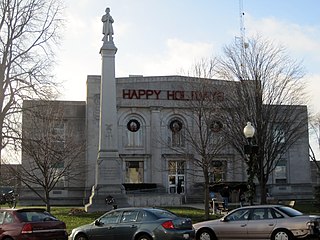
Grundy County is a county in the U.S. state of Illinois. According to the 2020 census, it has a population of 52,533. Its county seat is Morris.

<span class="mw-page-title-main">Ladd, Illinois</span> Village in Illinois, United States

Ladd is a village in Bureau County, Illinois, United States. The population was 1,236 at the 2020 census. It is part of the Ottawa Micropolitan Statistical Area. Ladd is perhaps most known for a Vietnam War tank located in the center of its park.

<span class="mw-page-title-main">Hanaford, Illinois</span> Village in Illinois, United States

Hanaford is a village in Franklin County, Illinois, United States. The population was 320 at the 2020 census. Hanaford is also known as Logan.

<span class="mw-page-title-main">Carbon Hill, Illinois</span> Village in Illinois, United States

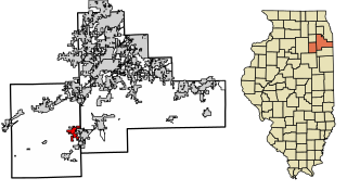
Carbon Hill is a village in Grundy County, Illinois, United States. The population was 372 at the 2020 census.

<span class="mw-page-title-main">Coal City, Illinois</span> Village in Illinois, United States

Coal City is a village in Grundy and Will Counties in the U.S. state of Illinois. It is considered a fringe town of the Chicago metropolitan area. The population was 5,705 at the 2020 census.

<span class="mw-page-title-main">Godley, Illinois</span> Village in Illinois, United States

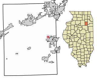
Godley is a village in Grundy and Will counties, Illinois, United States. The population was 566 at the 2020 census.

<span class="mw-page-title-main">Minooka, Illinois</span> Village in Illinois, United States

Minooka is a village in Grundy, Kendall, and Will counties, Illinois, United States. The population was 12,758 at the 2020 census, up from 10,924 at the 2010 census. The village is part of the Chicago metropolitan area.

<span class="mw-page-title-main">Seneca, Illinois</span> Village in Illinois, United States

Seneca is a village in LaSalle and Grundy counties in the U.S. state of Illinois. The population was 2,353 at the 2020 census, down from 2,371 at the 2010 census.

<span class="mw-page-title-main">South Wilmington, Illinois</span> Village in Illinois, United States

South Wilmington is a village in Grundy County, Illinois, United States. The population was 710 at the 2020 census.

<span class="mw-page-title-main">New Burnside, Illinois</span> Village in Illinois, United States

New Burnside is a village in Johnson County, Illinois, United States. The population was 211 at the 2010 census.

<span class="mw-page-title-main">Cedar Point, Illinois</span> Village in Illinois, United States

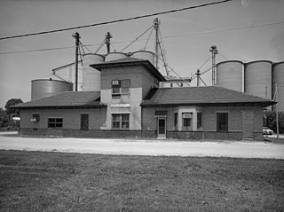
Cedar Point is a village in LaSalle County, Illinois, United States. The population was 266 at the 2020 census, down from 277 at the 2010 census. It is part of the Ottawa Micropolitan Statistical Area. North of town was the Cedar Point Mine, which operated from 1906 to 1924.

<span class="mw-page-title-main">Granville, Illinois</span> Place in Illinois, United States

Granville is a village in Putnam County, Illinois, United States. The population was 1,427 at the 2010 census, up from 1,414 in 2000, making it the largest community in Putnam County. It is part of the Ottawa Micropolitan Statistical Area.

<span class="mw-page-title-main">Galatia, Illinois</span> Village in Illinois, United States

Galatia is a village in Saline County, Illinois, in the United States. As of the 2010 census, the village population was 933.

<span class="mw-page-title-main">Aux Sable Township, Grundy County, Illinois</span> Township in Illinois, United States

Aux Sable Township is one of seventeen townships in Grundy County, Illinois, USA. As of the 2020 census, its population was 15,361 and it contained 5,184 housing units.

<span class="mw-page-title-main">Braceville Township, Grundy County, Illinois</span> Township in Illinois, United States

Braceville Township is one of seventeen townships in Grundy County, Illinois, USA. As of the 2010 census, its population was 6,463 and it contained 2,617 housing units.

<span class="mw-page-title-main">Erienna Township, Grundy County, Illinois</span> Township in Illinois, United States

Erienna Township is one of seventeen townships in Grundy County, Illinois, USA. As of the 2020 census, its population was 2,408 and it contained 974 housing units.

<span class="mw-page-title-main">Felix Township, Grundy County, Illinois</span> Township in Illinois, United States

Felix Township is one of seventeen townships in Grundy County, Illinois, USA. As of the 2020 census, its population was 4,438 and it contained 1,923 housing units.

<span class="mw-page-title-main">Garfield Township, Grundy County, Illinois</span> Township in Illinois, United States

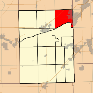
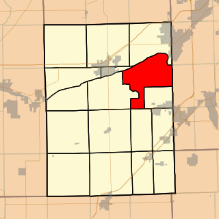
Garfield Township is one of seventeen townships in Grundy County, Illinois, USA. As of the 2020 census, its population was 1,454 and it contained 659 housing units.

<span class="mw-page-title-main">Goose Lake Township, Grundy County, Illinois</span> Township in Illinois, United States

Goose Lake Township is one of seventeen townships in Grundy County, Illinois, USA. As of the 2020 census, its population was 1,755 and it contained 811 housing units.

<span class="mw-page-title-main">Maine Township, Grundy County, Illinois</span> Township in Illinois, United States

Maine Township is one of seventeen townships in Grundy County, Illinois, USA. As of the 2020 census, its population was 293 and it contained 125 housing units.

References

  1. "2020 U.S. Gazetteer Files". United States Census Bureau. Retrieved March 15, 2022.
  2. 1 2 U.S. Geological Survey Geographic Names Information System: Diamond, Illinois
  3. 1 2 "Explore Census Data". data.census.gov. Retrieved June 28, 2022.
  4. "Grundy County". Jim Forte Postal History. Retrieved November 4, 2015.
  5. Callary, Edward (September 29, 2008). Place Names of Illinois. University of Illinois Press. p. 93. ISBN   978-0-252-09070-7.
  6. Gannett, Henry (1905). The Origin of Certain Place Names in the United States. Govt. Print. Off. pp.  106.
  7. "Coal City Public Library".
  8. "US Gazetteer files: 2010, 2000, and 1990". United States Census Bureau. February 12, 2011. Retrieved April 23, 2011.
  9. Bureau, US Census. "Gazetteer Files". Census.gov. Retrieved June 29, 2022.
  10. "Census of Population and Housing". Census.gov. Retrieved June 4, 2015.