Cape Town is a legislative capital of South Africa. Colloquially named the Mother City, it is the primate city of the Western Cape province. It forms part of the City of Cape Town metropolitan municipality.

John Selwyn Gummer, Baron Deben is a British Conservative Party politician, formerly Member of Parliament (MP) for Suffolk Coastal and now a member of the House of Lords.

The Northern Cape is the largest and most sparsely populated province of South Africa. It was created in 1994 when the Cape Province was split up. Its capital is Kimberley. It includes the Kalahari Gemsbok National Park, part of the Kgalagadi Transfrontier Park, an international park shared with Botswana. It also includes the Augrabies Falls and the diamond mining regions in Kimberley and Alexander Bay. The Namaqualand region in the west is famous for its Namaqualand daisies. The southern towns of De Aar and Colesberg, in the Great Karoo, are major transport nodes between Johannesburg, Cape Town and Port Elizabeth. In the northeast, Kuruman is known as a mission station and also for its artesian spring, the Eye of Kuruman. The Orange River flows through the province, forming the borders with the Free State in the southeast and with Namibia to the northwest. The river is also used to irrigate the many vineyards in the arid region near Upington.

The West Coast District Municipality is a district municipality located in the Western Cape province of South Africa. Its municipality code is DC1. Moorreesburg is the seat of the district. As of 2011 it had a total population of 391,766.
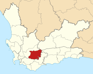
Langeberg Municipality is a local municipality located within the Cape Winelands District Municipality in the Western Cape province of South Africa. As of 2011 it had a population of 97,724. Its municipality code is WC026.

Bergrivier Local Municipality is a local municipality in the Western Cape province of South Africa. It governs the towns of Piketberg, Velddrif and Porterville, as well as the surrounding villages and rural areas. As of 2011 it had a population of 61,897. It is located within the West Coast District Municipality and has municipality code WC013.

Theewaterskloof Municipality is a local municipality located within the Overberg District Municipality, in the Western Cape province of South Africa. As of 2007, the population was 108,790. Its municipality code is WC031. The enormous Theewaterskloof Dam, which provides water for Cape Town and the surrounding areas, is located in this municipality.

Makhanda is a town of about 70,000 people in the Eastern Cape province of South Africa. It is situated about 110 kilometres (70 mi) northeast of Port Elizabeth and 130 kilometres (80 mi) southwest of East London. Makhanda is the largest town in the Makana Local Municipality, and the seat of the municipal council. It also hosts Rhodes University, the Eastern Cape Division of the High Court, The South African Library for the Blind (SALB) and a diocese of the Anglican Church of Southern Africa and 6 South African Infantry Battalion.
Sarah Baartman District Municipality is situated in the western part of the Eastern Cape province, covering an area of 58 242 square kilometres. The area of the district municipality includes nine local municipalities. The seat of Sarah Baartman is the city of Port Elizabeth, although Port Elizabeth is not itself in the district. The languages most spoken among the 388,201 people are Xhosa and Afrikaans.. The district code is DC10.

The City of Cape Town is the metropolitan municipality which governs the city of Cape Town, South Africa and its suburbs and exurbs. As of the 2011 census, it had a population of 3,740,026.

The River Deben is a river in Suffolk rising to the west of Debenham, though a second, higher source runs south from the parish of Bedingfield. The river passes through Woodbridge, turning into a tidal estuary before entering the North Sea at Felixstowe Ferry. The mouth of the estuary is crossed by a ferry connecting Felixstowe and Bawdsey.

Gamagara Local Municipality is an administrative area in the John Taolo Gaetsewe District of the Northern Cape in South Africa.

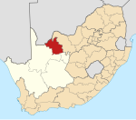
Dikgatlong Local Municipality is an administrative area in the Frances Baard District of the Northern Cape in South Africa. Dikgatlong is a Setswana name meaning "confluence", and refers to the place where the Harts and Vaal rivers flow into each other in Delportshoop. The name was used as early as 1700.

Dingleton is a town in Northern Cape, South Africa.

Solar power in South Africa includes photovoltaics (PV) as well as concentrated solar power (CSP). In 2016, South Africa had 1,329 MW of installed solar power capacity. Installed capacity is expected to reach 8,400 MW by 2030.
The Northern Cape province of South Africa is governed in a parliamentary system in which the people elect the provincial legislature and the legislature, in turn, elects the Premier as head of the executive. The Premier leads an Executive Council consisting of members who oversee various executive departments. The structure of the provincial government is defined by chapter six of the Constitution of South Africa.
Askham is a village in the Dawid Kruiper Local Municipality in the ZF Mgcawu District Municipality in the Northern Cape province of South Africa. Askham lies not far from the confluence of the mostly dry Molopo and Kuruman Rivers in the Red Kalahari Desert, about 200 km north of Upington at the junction of the R31 and the R360 roads.
Sanddrif is a town in Richtersveld Local Municipality in the Northern Cape province of South Africa, on the banks of the Orange River. It is located 57 km east of Alexander Bay.