Dickinson County, Michigan

Last updated

Dickinson County
2009-0619-IronMountain-Courthouse.jpg
Map of Michigan highlighting Dickinson County.svg
Location within the U.S. state of Michigan
Michigan in United States.svg
Michigan's location within the U.S.
Coordinates: 46°00′N87°52′W / 46°N 87.87°W / 46; -87.87
CountryFlag of the United States.svg United States
StateFlag of Michigan.svg  Michigan
Founded1891 [1] [2]
Named for Donald M. Dickinson
Seat Iron Mountain
Largest cityIron Mountain
Area
  Total777 sq mi (2,010 km2)
  Land761 sq mi (1,970 km2)
  Water16 sq mi (40 km2)  2.0%
Population
 (2020)
  Total25,947
  Density34/sq mi (13/km2)
Time zone UTC−6 (Central)
  Summer (DST) UTC−5 (CDT)
Congressional district 1st
Website www.dickinsoncountymi.gov

Dickinson County is a county in the Upper Peninsula of the U.S. state of Michigan. As of the 2020 census, the population was 25,947. [3] The county seat is Iron Mountain. [4] Dickinson is Michigan's newest county, formed in 1891 from parts of Marquette, Menominee, and Iron counties. [2] It was named for Donald M. Dickinson, who served as U.S. Postmaster General under President Grover Cleveland. [1] [2]

Contents

Dickinson County is part of the Iron Mountain, MI–WI micropolitan statistical area.

Geography

According to the U.S. Census Bureau, the county has a total area of 777 square miles (2,010 km2), of which 761 square miles (1,970 km2) is land and 16 square miles (41 km2) (2.0%) is water. [5] Along with its western neighbor Iron County, it is one of only two landlocked counties in the Upper Peninsula.

Major highways

Airport

Adjacent counties

Communities

U.S. Census data map showing local municipal boundaries within Dickinson County. Shaded areas represent incorporated cities. Dickinson County, MI census map.png
U.S. Census data map showing local municipal boundaries within Dickinson County. Shaded areas represent incorporated cities.

Cities

Charter township

Civil townships

Census-designated place

Other unincorporated communities

Demographics

Historical population
CensusPop.Note
1900 17,890
1910 20,52414.7%
1920 19,456−5.2%
1930 29,94153.9%
1940 28,731−4.0%
1950 24,844−13.5%
1960 23,917−3.7%
1970 23,753−0.7%
1980 25,3416.7%
1990 26,8315.9%
2000 27,4722.4%
2010 26,168−4.7%
2020 25,947−0.8%
2023 (est.)25,982 [9] 0.1%
U.S. Decennial Census [10]
1790-1960 [11] 1900-1990 [12]
1990-2000 [13] 2010-2018 [3]

In 2020, the county had a population of 25,947. [3]

The 2010 American Community Survey 3-year estimate indicated the median income for a household in the county was $42,331 and the median income for a family was $52,222. [14] Males had a median income of $31,402 versus $14,957 for females. The per capita income for the county was $22,583. About 3.4% of families and 10.9% of the population were below the poverty line, including 11.4% of those under the age 18 and 11.3% of those age 65 or over.

Government

United States presidential election results for Dickinson County, Michigan [15] [16]
Year Republican Democratic Third party
No.%No.%No.%
2020 9,61765.80%4,74432.46%2541.74%
2016 8,58064.84%3,92329.65%7295.51%
2012 7,68859.82%4,95238.53%2111.64%
2008 7,04952.96%5,99545.04%2672.01%
2004 7,73457.08%5,65041.70%1651.22%
2000 6,93254.02%5,53343.12%3672.86%
1996 4,40838.03%5,61448.43%1,56913.54%
1992 4,27332.79%5,68943.66%3,06923.55%
1988 6,15849.89%6,12949.66%560.45%
1984 6,88054.91%5,61444.80%360.29%
1980 6,61450.58%5,69443.54%7695.88%
1976 5,92248.63%6,13450.37%1210.99%
1972 5,98951.12%5,33945.57%3873.30%
1968 4,92043.95%5,72651.15%5484.90%
1964 3,36529.79%7,92170.12%110.10%
1960 5,33644.49%6,64555.40%140.12%
1956 6,20054.72%5,11345.13%170.15%
1952 6,04551.18%5,71048.34%560.47%
1948 4,41739.06%6,29555.66%5975.28%
1944 4,98742.11%6,74056.92%1150.97%
1940 6,18844.65%7,58254.71%890.64%
1936 4,56335.28%7,95261.48%4193.24%
1932 5,12042.55%6,48353.88%4293.57%
1928 5,84055.57%4,62644.02%430.41%
1924 4,53868.66%4006.05%1,67125.28%
1920 3,53976.65%58012.56%49810.79%
1916 2,39360.63%1,29132.71%2636.66%
1912 1,37140.90%36110.77%1,62048.33%
1908 2,50776.18%54416.53%2407.29%
1904 2,98487.84%2838.33%1303.83%
1900 2,85884.51%45113.34%732.16%
1896 2,60880.59%52816.32%1003.09%
1892 1,60651.05%1,25539.89%2859.06%
Dickinson County fairgrounds DickensonCountyMichiganFairgrounds.jpg
Dickinson County fairgrounds

The county government operates the jail, maintains rural roads, operates the major local courts, keeps files of deeds and mortgages, maintains vital records, administers public health regulations, and participates with the state in the provision of welfare and other social services. The county board of commissioners controls the budget but has only limited authority to make laws or ordinances. In Michigan, most local government functions — police and fire, building and zoning, tax assessment, street maintenance, etc. — are the responsibility of individual cities and townships. In the 2006 elections, it was also the most supportive county of proposal 2, a state constitutional amendment banning affirmative action programs. It received 74.2% support in the county.

The county was a bellwether in every presidential election from 1920 to 2004 (with exception to 1968).

Elected officials

(information as of July 2013) [17]

See also

Related Research Articles

<span class="mw-page-title-main">Florence County, Wisconsin</span> County in Wisconsin, United States

Florence County is a county located in the U.S. state of Wisconsin. As of the 2020 census, the population was 4,558, making it the second-least populous county in Wisconsin after Menominee County. Its county seat is Florence.

<span class="mw-page-title-main">Menominee County, Michigan</span> County in Michigan, United States

Menominee County is a county located in the Upper Peninsula in the U.S. state of Michigan. As of the 2020 census, the population was 23,502. The county seat is Menominee. The county's name comes from an American Indian word meaning "wild rice eater" used to describe a tribe. The county was created in 1861 from area partitioned out of Delta County, under the name of Bleeker. When county government was organized in 1863, the name was changed to Menominee.

<span class="mw-page-title-main">Marquette County, Michigan</span> County in Michigan, United States

Marquette County is a county located in the Upper Peninsula of the U.S. state of Michigan. As of the 2020 census, the population was 66,017. The county seat is Marquette. The county is named for Father Marquette, a Jesuit missionary. It was set off in 1843 and organized in 1851. Marquette County is the largest county in land area in Michigan, and the most populous county in the Upper Peninsula.

<span class="mw-page-title-main">Iron County, Michigan</span> County in Michigan, United States

Iron County is one of two landlocked counties in the Upper Peninsula of the U.S. state of Michigan. As of the 2020 census, the population was 11,631. The county seat is Crystal Falls.

<span class="mw-page-title-main">Delta County, Michigan</span> County in Michigan, United States

Delta County is a county in the Upper Peninsula in the U.S. state of Michigan. As of the 2020 census, the population was 36,903. The county seat is Escanaba. The county was surveyed in 1843 and organized in 1861. Its name originates from the Greek letter delta (Δ), which refers to the triangular shape of the original county which included segments of Menominee, Dickinson, Iron, and Marquette counties. Recreation and forest products are major industries, and crops include hay, corn, small grains, potatoes, and strawberries.

<span class="mw-page-title-main">Baraga County, Michigan</span> County in Michigan, United States

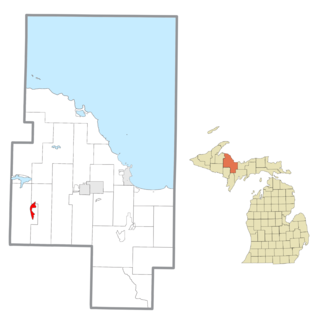
Baraga County is a county in the Upper Peninsula in the U.S. state of Michigan. As of the 2020 census, the population was 8,158, making it Michigan's fifth-least populous county. The county seat is L'Anse. The county is named after Bishop Frederic Baraga, a Catholic missionary who ministered to the Ojibwa Indians in the Michigan Territory.

<span class="mw-page-title-main">Breitung Charter Township, Michigan</span> Charter township in Michigan, United States

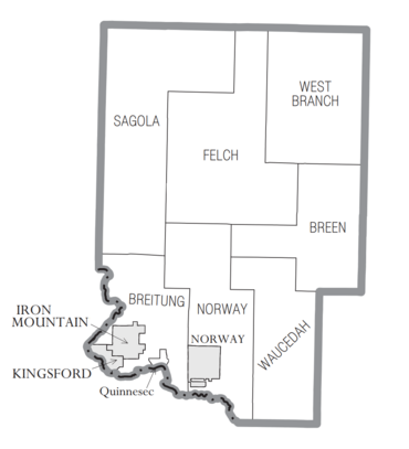
Breitung Charter Township is a charter township of Dickinson County in the U.S. state of Michigan. As of the 2020 census, the township population was 5,831.

<span class="mw-page-title-main">Felch Township, Michigan</span> Civil township in Michigan, United States

Felch Township is a civil township of Dickinson County in the U.S. state of Michigan, named in honor of Alpheus Felch. The population was 687 at the 2020 census.

<span class="mw-page-title-main">Iron Mountain, Michigan</span> City in Michigan, United States

Iron Mountain is a city and the county seat of Dickinson County, Michigan. The population was 7,518 at the 2020 census, down from 7,624 at the 2010 census. In the state's Upper Peninsula, Iron Mountain was named for the valuable iron ore found in the vicinity.

<span class="mw-page-title-main">Kingsford, Michigan</span> City in Michigan, United States

Kingsford is a city in Dickinson County, Michigan, United States. Its population was 5,139 at the 2020 census, a slight increase from the 5,133 recorded at the 2010 census. It was named for the developer Edward G. Kingsford.

<span class="mw-page-title-main">Norway, Michigan</span> City in Michigan, United States

Norway is a city in Dickinson County in the U.S. state of Michigan. The population was 2,840 at the 2020 census. It is part of the Iron Mountain, MI–WI micropolitan statistical area.

<span class="mw-page-title-main">Quinnesec, Michigan</span> Census-designated place & unincorporated community in Michigan, United States

Quinnesec is an unincorporated community in Dickinson County in the U.S. state of Michigan. It is a census-designated place (CDP) for statistical purposes and has no legally recognized status as a municipality. The population was 1,083 at the 2020 census. It is part of the Iron Mountain, MI–WI Micropolitan Statistical Area.

<span class="mw-page-title-main">Sagola Township, Michigan</span> Civil township in Michigan, United States

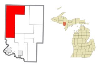
Sagola Township is a civil township of Dickinson County in the U.S. state of Michigan. The population was 1,066 at the 2020 census.

<span class="mw-page-title-main">West Branch Township, Dickinson County, Michigan</span> Civil township in Michigan, United States

West Branch Township is a civil township of Dickinson County in the U.S. state of Michigan. The population was 51 at the 2020 census.

<span class="mw-page-title-main">Marquette Township, Marquette County, Michigan</span> Charter township in Michigan, United States

Marquette Township is a charter township in Marquette County in the U.S. state of Michigan. The population was 4,140 at the 2020 census. The city of Marquette is located to the southeast of the township and is administratively autonomous.

<span class="mw-page-title-main">Michigamme, Michigan</span> Census-designated place & unincorporated community in Michigan, United States

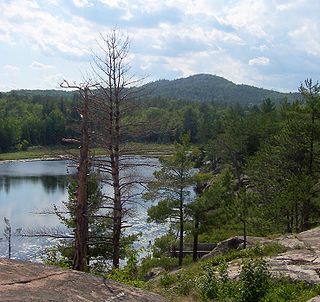
Michigamme is an unincorporated community in Marquette County in the U.S. state of Michigan. It is located within Michigamme Township on the north shores of Lake Michigamme. For statistical purposes, the United States Census Bureau has defined Michigamme as a census-designated place (CDP). The CDP had a population of 255 at the 2020 census.

<span class="mw-page-title-main">Powell Township, Michigan</span> Civil township in Michigan, United States

Powell Township is a civil township of Marquette County in the U.S. state of Michigan. The population was 732 at the 2020 census, down from 816 in 2010.

<span class="mw-page-title-main">Republic, Michigan</span> Census-designated place & unincorporated community in Michigan, United States

Republic is an unincorporated community in Marquette County in the U.S. state of Michigan. It is also a census-designated place (CDP) for statistical purposes and no legal status as an incorporated municipality. The CDP had a population of 470 at the 2020 census, down from 570 in 2010. The community is located mostly within Republic Township with a small portion extending north into Humboldt Township.

<span class="mw-page-title-main">Meyer Township, Michigan</span> Civil township in Michigan, United States

Meyer Township is a civil township of Menominee County in the U.S. state of Michigan. The population was 992 at the 2020 census. Most of the population is concentrated in Hermansville, an unincorporated village within the township.

<span class="mw-page-title-main">Iron Mountain micropolitan area</span> Combined Statistical Area in the United States

The Iron Mountain Micropolitan Statistical Area, as defined by the United States Census Bureau, is an area consisting of two counties – one in Michigan and one in Wisconsin – anchored by the city of Iron Mountain, Michigan. As of the 2000 census, the μSA had a population of 32,560.

References

  1. 1 2 "Bibliography on Dickinson County". Clarke Historical Library, Central Michigan University . Retrieved July 6, 2013.
  2. 1 2 3 "County History/Development". Dickinson County, Michigan. Retrieved February 25, 2013.
  3. 1 2 3 "State & County QuickFacts". United States Census Bureau. Retrieved September 15, 2021.
  4. "Find a County". National Association of Counties. Archived from the original on May 31, 2011. Retrieved June 7, 2011.
  5. "2010 Census Gazetteer Files". United States Census Bureau. August 22, 2012. Archived from the original on November 13, 2013. Retrieved September 21, 2014.
  6. "Antoine". Geographic Names Information System . United States Geological Survey, United States Department of the Interior.
  7. Romig, Walter (1986) [1973]. Michigan Place Names. Detroit, Michigan: Wayne State University Press. ISBN   0-8143-1838-X.
  8. U.S. Geological Survey Geographic Names Information System: Spruce
  9. "Annual Estimates of the Resident Population for Counties: April 1, 2020 to July 1, 2023". United States Census Bureau. Retrieved April 4, 2024.
  10. "U.S. Decennial Census". United States Census Bureau. Retrieved September 21, 2014.
  11. "Historical Census Browser". University of Virginia Library. Retrieved September 21, 2014.
  12. "Population of Counties by Decennial Census: 1900 to 1990". United States Census Bureau. Retrieved September 21, 2014.
  13. "Census 2000 PHC-T-4. Ranking Tables for Counties: 1990 and 2000" (PDF). United States Census Bureau. Archived (PDF) from the original on March 27, 2010. Retrieved September 21, 2014.
  14. "U.S. Census website". United States Census Bureau . Retrieved July 6, 2013.
  15. "Dave Leip's Atlas of U.S. Presidential Elections".
  16. The leading "other" candidate, Progressive Theodore Roosevelt, received 1,337 votes, while Socialist candidate Eugene Debs received 233 votes, Prohibition candidate Eugene Chafin received 43 votes, and Socialist Labor candidate Arthur Reimer received 7 votes.
  17. "Dickinson County Elected Officials" . Retrieved July 6, 2013.

46°00′N87°52′W / 46.00°N 87.87°W / 46.00; -87.87