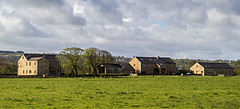
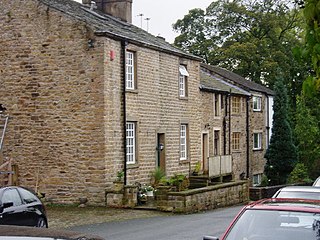
Read is a village in Lancashire 5 miles west northwest of Burnley and 2 miles east of Whalley. It is on the A671 which is the main road between Burnley and Clitheroe. The population of the civil parish as taken at the 2011 census was 1,419.

West Lancashire is a local government district with borough status in Lancashire, England. The council is based in Ormskirk, and the largest town is Skelmersdale. The district borders Fylde to the north, over the Ribble Estuary; South Ribble, Chorley, and Wigan to the east; St Helens, and Knowsley to the south; and Sefton to the south and west.

South Ribble is a local government district with borough status in Lancashire, England. Its council is based in Leyland. The borough also includes the towns and villages of Penwortham, Leyland, Farington, Hutton, Longton, Walmer Bridge, Salmesbury, Lostock Hall, Walton le Dale and Bamber Bridge. Many of the built-up areas in the borough form part of the wider Preston built-up area.

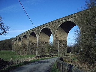
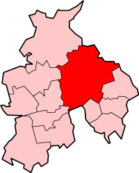
Ribble Valley is a local government district with borough status in Lancashire, England. Its council is based in Clitheroe, the largest town. The borough also includes the town of Longridge and numerous villages and surrounding rural areas. It is named after the River Ribble. Much of the district lies within the Forest of Bowland, a designated Area of Outstanding Natural Beauty.

The Borough of Burnley is a local government district with the borough status in Lancashire, England. It has an area of 42.7 square miles (110.7 km2) and a population of 94,721 (2021), and is named after its largest town, Burnley. The borough also contains the town of Padiham along with several villages and surrounding rural areas.
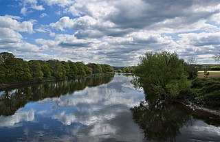
The River Ribble runs through North Yorkshire and Lancashire in Northern England. It starts close to the Ribblehead Viaduct in North Yorkshire, and is one of the few that start in the Yorkshire Dales and flow westwards towards the Irish Sea.

Ribble Valley is a constituency in Lancashire represented in the House of Commons of the UK Parliament since 1992 by Nigel Evans, a Conservative. Evans has served as a Deputy Speaker of the House of Commons and Second Deputy Chairman of Ways and Means since January 2020; he previously served as First Deputy Chairman of Ways and Means from 2010 to 2013.

Farington is a village and civil parish in the South Ribble local government district of Lancashire, England. The population of the civil parish at the 2011 census was 6,674.
Bamber Bridge is a large village in Lancashire, England, 3 miles (5 km) south-east of Preston, in the borough of South Ribble. The name derives from the Old English "bēam" and "brycg", which probably means "tree-trunk bridge". People who live in Bamber Bridge like to be known as Briggers.

Aighton, Bailey and Chaigley is a civil parish in the Borough of Ribble Valley in Lancashire, England, just west of Clitheroe. The population of the civil parish at the 2011 census was 1,307, an increase from 1,249 in 2001.

Slaidburn is a village and civil parish within the Ribble Valley district of Lancashire, England. The parish covers just over 5,000 acres of the Forest of Bowland.

Billington and Langho is a civil parish in the Ribble Valley district of Lancashire, England, covering the villages of Billington and Langho and the hamlets of York and Old Langho and the gated community called Brockhall Village.

Chipping is a village and civil parish in the borough of Ribble Valley, Lancashire, England, within the Forest of Bowland Area of Outstanding Natural Beauty. Its grid reference is SD6243, and the nearest substantial settlement is Longridge, nearly 4 mi (6.4 km) to the south. In the 2001 census, the parish had a population of 1,046, falling slightly to 1,043 at the 2011 census. The village has won several best-kept village competitions over the years. The village also won the village section of the Royal Horticultural Society Britain in Bloom competition in 2009, picking up RHS Tourism and Gold achievement awards in the process.
Ramsgreave is a civil parish in the Ribble Valley district of Lancashire, England. The parish is located on the northern edge of Blackburn although it is just outside the Blackburn with Darwen unitary district, and although the south and east of the parish is suburban, the parish also includes a rural area including Ribble Valley's only greenbelt land. The population of the civil parish taken at the 2011 census was 817. It is served by Ramsgreave and Wilpshire railway station. There are approximately 6 miles of footpaths and 2.5 miles of road within the parish.

Gisburn is a village and civil parish within the Ribble Valley borough of Lancashire, England. Historically within the West Riding of Yorkshire, it lies 8 miles (13 km) northeast of Clitheroe and 11 miles (18 km) west of Skipton. The civil parish had a population of 506, recorded in the 2001 census, increasing to 521 at the 2011 Census.
Wiswell is a small village and civil parish in the Ribble Valley, Lancashire, England, close to Whalley and Clitheroe at the foot of Wiswell Moor.

Pendleton is a small village and civil parish in Ribble Valley, within the county of Lancashire, England. It is close to the towns of Whalley and Clitheroe. The parish lies on the north west side of Pendle Hill below the Nick o' Pendle. The village is just off the A59, Liverpool to York main road, since the construction of the Clitheroe By-Pass. Older roads through the parish include one from Clitheroe to Whalley which passes through the Standen area and another to Burnley which passes Pendleton Hall.

Newsholme is a small village and civil parish in the Ribble Valley, Lancashire, England, but lies within the historic West Riding of Yorkshire. According to the 2001 census, the parish had a population of 50, however the United Kingdom Census 2011 grouped the parish with Horton and Paythorne, giving a total of 253. Today it lies near the boundary with North Yorkshire on the A682, 4 miles (6 km) north of Barnoldswick and 12 miles (19 km) west of Skipton.
Ribble Valley Borough Council elections are held every four years. Ribble Valley Borough Council is the local authority for the non-metropolitan district of Ribble Valley in Lancashire, England. Since the last boundary changes in 2019, 40 councillors have been elected from 26 wards.

The City of Preston, or simply Preston, is a local government district with city status in Lancashire, England. It lies on the north bank of the River Ribble and has a population of 147,617 (2021). The neighbouring districts are Ribble Valley, South Ribble, Fylde and Wyre.