Dir (princely state)

Last updated

Dir
دير
Princely state of British India and West Pakistan
c.1800s–28 July 1969
Flag of the State of Dir 2.svg
Flag
Dir map.png
Dir (highlighted red) shown within the former exclave of West Pakistan
Capital Dir
Area 
 
5,282 km2 (2,039 sq mi)
History
History 
 Established
c.1800s
 Disestablished
28 July 1969
Today part of Pakistan
 · Khyber Pakhtunkhwa

Dir was a princely state in a subsidiary alliance with the British Raj, located within the North-West Frontier Province. Following the Partition of British India, Dir remained independent and unaligned until February 1948, when the Dominion of Pakistan accepted its accession.

Contents

The princely state ceased to exist as a distinct political entity in 1969, when it was fully incorporated into Pakistan. The territory it once covered is today located in the Pakistani province of Khyber Pakhtunkhwa, forming two northern and southern districts called Upper Dir and Lower Dir, respectively.

Geography

Most of the state lay in the valley of the Panjkora river, which originates in the Hindu Kush mountains and joins the Swat River near Chakdara. Apart from small areas in the south-west, Dir is a rugged, mountainous zone with peaks rising to 5,000 metres (16,000 ft) in the north-east and to 3,000 metres (9,800 ft) along the watersheds, with Swat to the east and Afghanistan and Chitral to the west and north.

History

Early period

Dir took its name from its main settlement, Dir, the location of the ruler's palace.

The territories surrounding Dir were populated by their current ethnic majority, the Pakhtuns, beginning from the end of the 14th century. The Pakhtun were divided in several clans (khels), often battling one against the other. The three clans which conquered the zone were the Yusafzai (Painda Khel, Sultan Khel, Osakhel, Nasirdinkhel), Tarkanrai. The Dir territory was populated in the 16th century by the Malizai sub-tribe of the Yusufzai, who took control of the zone assimilating or chasing away the previous inhabitants (Dilazak in Bajour, Jandool, Maiden, and Swatis from areas east of Panjkora) [1] and within this tribe the most prominent fractions became the Painda khel and Sultan khel. [2]

By the 17th century a section of the Painda khel, coming from the Kohan village in the valley of Nihag (a Panjkora tributary), seized the trade routes with Chitral and Afghanistan. [2]

Ruling Khans

The Khanate is said to have been established in the 17th century by Painda khel leader and charismatic mystic figure Akhund Ilyas Khan (Baba), who found the State of Dir. [3] His descendants took the name Akhund khel, preserving and expanding their leadership becoming the Khans of Dir. [4] [1] [2]

Jandool Rule and Fort

Muhammad Umara Khan took power while killing his brother inside the fort and succeeded as the Khan of Jando(o)l.

According to the Sultan Alam Khan (age 90-+ years), "Umara Khan killed his real brother inside the fort," added his son, Sardar Alam Khan, in the historical narration about Umara Khan.

This was the beginning of Umara Khan's control. Later on, he had the Jandool Fort constructed. The large building inside the fort was built in 1960 by Nawabzada Shahabuddin Khan (known as Jandool Khan), the son of Shah Jehan Khan (the then Nawab of Dir). The fort is located strategically controlling the four directions with the bordering area of Bajaur, which borders Afghanistan. The Father of Jan Alam Khan (son of Sultan Alam Khan) related that before shifting / use of this fort, the government of Pakistan took over charge of the Fort at night time. Thus this building remain vacant till the date this was used by Sultan Yousaf (son of Sultan Alam Khan) for the educational purpose as allowed by ex-royal family members after 04 decades of remaining vacant the said Fort.

Jandool Fort was built with purpose of defence. Its corners contain the watch towers and thus the fighters can control either side of the building to keep enemies away. The building has a large number of facilities including a cooking area for hundreds of fighters. A water pond in the middle of the lawn not only provides a good source of water but also adds some beauty to the place. The sons/grandsons of Umara Khan are not living in the Dir area, but their servants are residing beside the building. The fort has lush green areas on four-sides, large trees are adding charm to its beauty, the reception is designed with the aim of receiving guests with honour and good protocols.

In 1881 the ruler of Dir, Muhammad Sharif Khan, was chased away by Khan Umara Khan of Jandool, who conquered Dir, Swat, and the Malakand area. In 1895, however, while the forces of Umara Khan were besieging a British Force near Malakand, Muhammad Sharif Khan decided to make his soldiers join the British Relief Force coming in aid, the Chitral Expedition. During that expedition, Sharif Khan made an agreement with the British Government to keep the road to Chitral open in return for a subsidy. [5] The British eventually won the war and exiled Umara Khan as part of the dual game by British with Umara Khan. This was as a reward for Sharif Khan's help, Sharif Khan was given the whole of Dir and also the lower Swat (the latter territory would be lost in 1917 to the Wali of Swat). [2]

Eventually Umara Khan left the area and went to Kabul, his resting place is in Kabul. The great conqueror was in Afghanistan, far away from the area he belongs to. Strange behavior of British Forces' officers was noted, he is considered as a hero for the Afghans/Pakhtoons of the Dir State.

The ruling Nawabs

The hereditary Nawab Khan Bahador title (nawab for short) was granted in 1897 to Mohammad Sharif Khan and inherited by Sharif's eldest son, [1] Aurangzeb Badshah Khan (nicknamed as Charha Nawab), who ruled between 1904 and 1925. In 1906 his younger brother, Miangul Jan (Munda Khan), tried in vain to wrest power with the assistance of the Khan of Barwa, Sayed Ahmad Khan, a former ally of Mohammad Sharif. A second attempt in 1913 was crowned by success, but for a very short time, [1] as in 1914 Aurangzeb regained the rule over Dir.[ citation needed ] Also, the other son of Mohammad Sharif, Mohammad Isa Khan, attempted around 1915 to seize the Dir throne by allying with the Khan of Barwa, but Aurangzeb managed to preserve his rule. [1]

At Aurangzeb's death, in 1925, the title passed to his eldest son, Mohammad Shah Jahan Khan, who was supported by the British Government against the small rival faction that favored his brother Alamzeb Khan. Alamzeb was exiled in 1928 because of his attempts to take power. Shah Jahan Khan was loyal to the British, who nominated him to KBE in 1933. [1] In 1947, Jahan Khan sent his troops to support Pakistan during the First Kashmir War, and in 1948 united his princely state with the new Dominion of Pakistan. [6] He also nominated his son Muhammad Shah Khan Khusro as successor and other sons (Shahabuddin Khan and Mohammad Shah) governors of different provinces. [2]

Pakistan

On 8 Feb 1948, Dir acceded to the newly created Muslim dominion of Pakistan, initially continuing as one of the surviving princely states of Pakistan. The politics of the late Nawabs are described as reactionary and harsh. [2] [7] The Italian anthropologist Fosco Maraini, who visited the state in 1959 during an expedition towards Hindu-Kush, reported the opinion of the people that the Nawab Jahan Khan (who was about 64 years old at that time) was a tyrannical leader, denying his subjects any freedom of speech and instruction, governing the land with a number of henchmen, and seizing for his harem any girl or woman he wanted. Maraini also noticed the lack of schools, sewers, and paved roads, and the presence of just a rudimentary newly built hospital. The Nawab was negatively compared to the Wali of Swat, whose liberal politics allowed his state to enter into the modern era. [8]

As a consequence, uprisings began eventually to explode. A repressed revolt in 1959 is reported in Maraini's account. [8] Another insurrection in 1960 led to the death of 200 soldiers and put the Nawab in a bad light in the view of the press. General Yahya decided to exile Jahan Khan, who would die in 1968. His throne passed in October 1961 to his eldest son, Mohammad Shah Khosru Khan, educated in India and a serving Major General of the Pakistan Army. However, the effective rule of Dir was taken by the Pakistani government's Political Agent.

A few years later, on 28 July 1969, the Dir state was incorporated into Pakistan, ceasing its political existence. [2] The royal status of the Nawabs was abolished in 1972, at the same time as most other princes of Pakistan.[ citation needed ] [9]

Rulers Timeline

The information for the following table stems from Who's Who in the Dir, Swat, and Chitral Agency. [1] Encyclopædia Britannica [3] and accounts by local people [10] dating back to the 17th century.

TenureRuler
1626–1676Akhund Baba (Mulla Ilyas Khan)
1676–1752Mulla Ismail
1752–1804Ghulam Khan Baba
1804–1814Khan Zafar Khan
1814–1822Khan Qasim Khan
1822–1868Khan Ghazzan Khan
1868-1870Ghasan Khan
1870–1884Khan Rahmat Allah (Rahmatullah) Khan
1886–1890Mohammad Sharif Khan
1890– 1895Mohammad Umara Khan
1895-1904Nawab Mohammad Sharif Khan
1904–1913Nawab Awrangzeb Badshah Khan (first time)
1913–1914Nawab Miangul Jan
1914-1925Nawab Awrangzeb Badshah Khan (second time)
1925–1947Nawab Mohammad Shah Jahan Khan
1947-1960 Nawabzada Shahabuddin Khan
1960–IncumbentNawab Khosru Khan

Demographics

The population of the state in 1911 amounted to about 100,000 people according to Encyclopædia Britannica, [5] rising to 250,000 in 1931 and falling back to 107,000 in 1951.

At the 1947 Partition of India, there was a Muslim majority in Dir with small minorities of Hindus and Sikhs, many of whom left for India during partition.

Flag

The state flag contained several Islamic symbols and three sentences: the top writing is the Bismillah: "In the name of God, the Most Gracious, the Most Merciful", the center one is the shahada in the Urdu language: "There is no god but God, Muhammad is the messenger of God". The bottom phrase reads "with the help of God, victory is near" in the Arabic language. The flag also had a red variant with the same drawings. [11]

Notable People

See also

Related Research Articles

The Yusufzai or Yousafzai, also referred to as the Esapzai, or Yusufzai Afghans historically, are one of the largest tribes of ethnic Pashtuns. They are natively based in the northern part of Khyber Pakhtunkhwa, to which they migrated to from Kabul during the 16th century, but they are also present in smaller numbers in parts of Afghanistan, including Kunar, Kabul, Kandahar and Farah. Outside of these countries, they can be found in Ghoriwala District Bannu, Balochistan Sibi (Akazai), Chagai (Hassanzai) and Rohilkandh.

Miangul Jahan Zeb HPk, HQA, CIE, also known as Miangul Abdul-Haq Jahan Zeb, was the Wāli of Swat from 1949 to 1969, a princely state that is now part of Pakistan. He succeeded his father, Wadud of Swat. He is remembered for building schools, hospitals, and roads, but also for his absolute rule over the region, which ended in 1969. When Pakistan came into being, Wadud of Swat declared the accession of Swat State to Pakistan on November 23, 1947. Muhammad Ali Jinnah, the Governor-General of Pakistan, accepted the Instrument of Accession on November 24, 1947. Wadud of Swat announced his resignation in favor of his son Jehanzeb. Jahanzeb also worked to protect the landmarks of previous cultures.

<span class="mw-page-title-main">Amb (princely state)</span> Former princely state of the British Indian Empire and Pakistan

Amb or the Kingdom of Amb was a princely state in the present day Khyber Pakhtunkhwa region of Pakistan. Together with Phulra, it was known as Feudal Tanawal. ruled by Tanoli tribe a Royal Tenure start from Timurid Empire and end on Last Nawab Muhammad Farid Khan Tanoli, Amb was only Powerful state with Arms Civilized Military of 12,000 Mens, 300 Howitzer with there own Manufacturing Arms Factory Today Part of Pakistan army. Amb had a influence control roots in Swat, Dir and Chitral, A gaining of powerful roots of Amb military start from Second Anglo-Sikh War when East India Company provide military equipment to Jehandad Khan Tanoli to fight against Sikh, and then next Second anglo-Afghan War At the end of December 1947, the Nawab of Amb state acceded to Pakistan while retaining internal self-government. Amb continued as a princely state of Pakistan until 1969, when it was incorporated into the North West Frontier Province.

<span class="mw-page-title-main">Umra Khan</span>

Ghazi Khan Umara Khan of Jandol, also called "The Afghan Napoleon", was a Pashtun chief on the north-western frontier of British India, who was chiefly responsible for the Chitral Expedition of 1895. Umar Khan started his series of conquest and battles from Dir, Swat, Bajaur, Kunar, Kafiristan and in 1892 Umara Khan attacked Chitral and occupied Chitral.

<span class="mw-page-title-main">Bhopal State</span> Islamic principality in India (1708–1949)

Bhopal State was an Islamic principality founded in the beginning of 18th-century India by the Afghan Mughal noble Dost Muhammad Khan. It was a tributary state during 18th century, a princely salute state with 19-gun salute in a subsidiary alliance with British India from 1818 to 1947, and an independent state from 1947 to 1949. Islamnagar was founded and served as the State's first capital, which was later shifted to the city of Bhopal.

<span class="mw-page-title-main">Dir District</span> Place in Pakistan

Dir is a region in northwestern Pakistan in the Khyber Pakhtunkhwa, in the foothills of the Himalayas. Before the independence of Pakistan, Dir was a princely state, and it remained so until 1969 when it was abolished by a presidential declaration, and the Dir District was created the following year. The area covers 5,280 square kilometres. In 1996 Dir district was officially divided into Lower Dir District and Upper Dir District.

<span class="mw-page-title-main">Malakand Division</span> Administrative division of Khyber Pakhtunkhwa, Pakistan

Malakand Division is an administrative division of Khyber Pakhtunkhwa province of Pakistan. It contains the following districts:

<span class="mw-page-title-main">Lower Dir District</span> District of Khyber Pakhtunkhwa in Pakistan

Lower Dir District is a district in the Khyber Pakhtunkhwa province of Pakistan. Timergara city is the district's headquarter. This district was formed in 1996, when Dir District was divided into Upper Dir and Lower Dir districts. Recently, On 22 January 2023, both Lower Dir and Upper Dir districts further bifurcated to create a new Central Dir District.

<span class="mw-page-title-main">Upper Dir District</span> District of Khyber Pakhtunkhwa in Pakistan

Upper Dir District is a district located in the Malakand Division of Khyber Pakhtunkhwa province of Pakistan. The city of Dir is its district headquarter. Geographically, it is located in the northern part of Pakistan. It borders with the Chitral district on the north, Afghanistan on the northwest, the Swat district on the east, and the Lower Dir district on the south. It shares 40 to 50 kilometers border with Afghanistan.

The Utmankhel is a Pashtun tribe present in Pakistan, with substantial numbers in Afghanistan. They lie between the Mohmands and the Ranizais of Swat, to the west and south-west of the junction of the Swat and Panjkora rivers. The Utmankhel mostly living in Malakand, Bajaur, Mohmand, Lower Dir, Mardan and Orakzai. The Utmankhel are Pashtuns, part of the Karlani tribal confederacy, who fought against British and Mughals emperors in Pakhtunkhwa. The British regarded the Utmankhel tribesmen as “warlike” peoples and one of the Martial Race. The Utmankhel are a tall, stout and fair race, but their dress and general customs have been assimilated by the neighboring peoples of Bajaur. Utmankhel speak the same dialect of Pashtu called Yousafzai Pashto.

<span class="mw-page-title-main">Malakand Agency</span> Administrative division of British India and later Pakistan

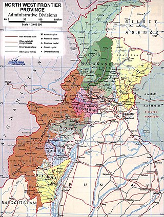
The Malakand Agency was one of the agencies in the North West Frontier Province of British India and later of Pakistan until 2010. It included the princely states of Chitral, Dir and Swat, and an area around the Malakand Pass known as the Malakand Protected Area. The largest city in the area was Mingora, while the three state capitals were Chitral, Dir, and Saidu Sharif. In 1970, following the abolition of the princely states, the agency became the Malakand Division, which was divided into districts, one of which was the Malakand Protected Area, known as Malakand District. In 2000 the Malakand Division was abolished. Despite the constitutional changes since 1970, the expression Malakand Agency is still used, sometimes of the entire area of the former Agency, but more often of Malakand District.

The Wāli of Swat was the official title of the leader (wāli) of the Miangul dynasty that ruled over the state of Swat between 1857 and 1969.

<span class="mw-page-title-main">Batkhela</span> City in Khyber Pakhtunkhwa, Pakistan

Batkhela is a city, tehsil and the district headquarter of the Malakand District within the Khyber Pakhtunkhwa province of Pakistan. According to the 2017 Census of Pakistan, the population of Batkhela was recorded at 68,200. Batkhela is considered as one of the most popular business cities in the Khyber Pakhtunkhwa province. A water canal that pours into a small dam in the Jabban area near Batkhela is the main source of electricity production here.

<span class="mw-page-title-main">Thana, Malakand</span> Village in Pakistan

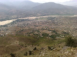
Thana is the biggest city of Malakand District. The name is derived from the Pashto word "Thanrha" which means "Place Of Courting", and was a main political center during the tribal period. The literacy Rate in the city is approximately 95% and the poverty rate is approx 24%. The nominal GDP of the city Thana is approx $690 million. The area is 230 km (140 mi) and the elevation is 950 metres (3,120 ft). The average snowfall is 2.3 cm (0.91 in).

<span class="mw-page-title-main">Dara Utmankhel</span>

Dara Utmankhel, also known as Shaikhan, is a valley in the Lower Dir District of Khyber Pakhtunkhwa, Pakistan. It consists of nine villages: Maniband ما نی بند, Jabaghi جبګۍ, Zara Doghy زړه ډوګۍ, Kot Koshah کوټ کو شاه, Mandal Korona کورونه ماندل, Kot کوټ, Ghwandy غونډئ, Fazal Abad and Shah Kuronu شاه کو رونه. It lies in Timergara tehsil, east of the main road from Timergara to Dir. The inhabitants of this area belong to the Mandal, a clan of Utmankhel tribe of Pashtuns. The Utmankhel is one of the Karlanri Pashtun or Afghan tribes who appeared in concert with other tribes like Yousafzai and Tarkalani. They first settled in the areas of Malakand, Bajaur and Mohmand. These people were mainly associated with trade as the land was not suitable for agriculture.

<span class="mw-page-title-main">Princely states of Pakistan</span> Territories incorporated into Pakistan from 1947 to 1974

The princely states of Pakistan were princely states of the British Indian Empire which acceded to the new Dominion of Pakistan between 1947 and 1948, following the partition of British India and its independence.

Miangul Abdul Wadud was the Wāli of Swat and grandson of the Akhund of Swat. He was elected Badshah Sahib (king) of Swat by a loya jirga held at Kabal in November 1918, and was recognized by the British authorities as ruler and formally installed as Wāli of Swat in Saidu Sharif on 3 May 1926. He ruled from 1918 to 1949, when he abdicated in favour of his eldest son, Miangul Jahan Zeb.

<span class="mw-page-title-main">Manglawar</span> Union council in Khyber-Pakhtunkhwa, Pakistan

Manglawar is an administrative unit, known as Union council of Tehsil Babuzai, of Swat District in the Khyber Pakhtunkhwa province of Pakistan and former capital of Kingdom of Swat. It is located at 34°48'30.7"N 72°25'50.0"E with an average altitude of 987 meters.

<span class="mw-page-title-main">Nawabzada Shahabuddin Khan</span> Khan of Jandool, Pakistan (1932-2007)

Nawabzada Muhammad Shahabuddin Khan was the last Khan of Jandol, a princely state that is now part of Lower Dir District, Pakistan from 1947 to 1969. He is remembered for building schools, hospitals, forts and roads but also for his absolute rule over the region, which ended when Pakistan took control of Dir after local unrest.

<span class="mw-page-title-main">Dir Levies</span> Pakistani paramilitary gendarmerie

The Dir Levies is a paramilitary force in the Dir District of the Pakistani province of Khyber Pakhtunkhwa. It operates as the primary law enforcement agency tasked with maintaining law and order within the division. The force has its origins back in the days of the British Raj, and has continued to function for over a century.

References

  1. 1 2 3 4 5 6 7 Who's Who in the Dir, Swat and Chitral Agency – Corrected up to 1st September 1933 (PDF). New Delhi: The Manager Government of India Press. 1933. Retrieved 31 July 2013.
  2. 1 2 3 4 5 6 7 Syed Ziafat Ali. "Welcome To Dir State" . Retrieved 13 August 2013.
  3. 1 2 Dir at the Encyclopædia Britannica
  4. Rose, Horace Arthur; Ibbetson, Denzil; Maclagan, Edward Douglas (1911). A Glossary of the Tribes and Castes of the Punjab and North-West Frontier Province: A.-K, Volume 2. Lahore: Printed by the superintendent, Government Printing, Punjab. p. 11. Retrieved 31 July 2013.
  5. 1 2 Chisholm, Hugh, ed. (1911). "Dir"  . Encyclopædia Britannica . Vol. 8 (11th ed.). Cambridge University Press. p. 309.
  6. Jinnah Papers The states: Historical and Policy Perspectives and Accession to Pakistan. First series volume VIII, Editor: Z.H.Zaidi, Quaid-i-Azam Papers Project, Government of Pakistan 2003 Pg xxxix.
  7. Jinnah Papers The states: Historical and Policy Perspectives and Accession to Pakistan, First series volume VIII, Editor: Z.H.Zaidi, Quaid-i-Azam Papers Project, Government of Pakistan 2003 Pg xvii.
  8. 1 2 Maraini, Fosco (1965). Where four worlds meet: Hindu Kush, 1959. London: Hamish Hamilton.
  9. "Dir Royal Family[Akhun khel]: History".
  10. "Call for preservation of Sufi shrine in Dir". Dawn. 14 January 2013. Retrieved 31 July 2013.
  11. Roberto Breschi. "Dir" . Retrieved 25 July 2013.. The site cites J. D. McMeekin, Arms and Flags of the Indian Princely States, 3, sec. 12, 1990.