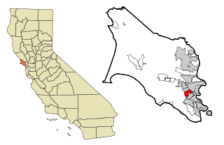
Marin County is a county located in the northwestern part of the San Francisco Bay Area of the U.S. state of California. As of the 2020 census, the population was 262,231. Its county seat and largest city is San Rafael. Marin County is across the Golden Gate Bridge from San Francisco, and is included in the San Francisco–Oakland–Berkeley, CA Metropolitan Statistical Area.

San Anselmo is an incorporated town in Marin County, California, United States. San Anselmo is located 1.5 miles (2.4 km) west of San Rafael, at an elevation of 46 feet. It is located about 20 miles (32 km) north of San Francisco. The town is bordered by San Rafael to the east, Fairfax to the west, and Ross to the south. Mount Tamalpais dominates the view to the south. The population was 12,830 at the 2020 census.

Corte Madera is an incorporated town in Marin County, California. Corte Madera is located 3.25 miles (5.2 km) south of San Rafael, at an elevation of 39 feet. The population was 10,222 at the 2020 census. The town was named after the Spanish imperative command "chop wood", as the area was famous for producing redwood tree lumber which was used in the construction of the city of San Francisco.
Kentfield is a census-designated place (CDP) in Marin County, California, United States, just north of San Francisco. Kentfield is located 2 miles (3 km) southwest of downtown San Rafael, at an elevation of 115 feet. The population was 6,808 at the 2020 census. The ZIP codes are 94904 for street addresses, and 94914 for PO boxes, and are shared with the neighboring community of Greenbrae.

Lucas Valley-Marinwood is a census-designated place (CDP) in Marin County, California, United States. It includes the neighborhoods of Lucas Valley and Marinwood. As of the 2020 census, the population was 6,259.

Mill Valley is a city in Marin County, California, United States, located about 14 miles (23 km) north of San Francisco via the Golden Gate Bridge and 52 miles (84 km) from Napa Valley. The population was 14,231 at the 2020 census.
Novato is a city in Marin County, California, in the North Bay region of the Bay Area. At the 2020 census, Novato had a population of 53,225.

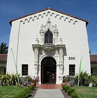
San Rafael is a city and the county seat of Marin County, California, United States. The city is located in the North Bay region of the San Francisco Bay Area. As of the 2020 U.S. census, the city's population was 61,271, up from 57,713 in 2010.

Stinson Beach is an unincorporated community and census-designated place (CDP) in Marin County, California, on the west coast of the United States. Stinson Beach is located 2.5 miles (4 km) east-southeast of Bolinas, at an elevation of 26 feet (8 m). The population of the Stinson Beach CDP was 541 at the 2020 census.

Nicasio is an unincorporated community and census-designated place in Marin County, California, United States. It is located 8 miles (13 km) west-southwest of Novato, at an elevation of 194 feet (59 m). As of the 2020 census the CDP population was 81, while population estimates for the surrounding area range from about 600 to about 900 people.

Marin City is an unincorporated community and census-designated place (CDP) in Marin County, California, United States. As of the 2020 census, it had a population of 2,993, up from 2,666 in 2010. It is located 1.5 miles northwest of downtown Sausalito, 8 miles (13 km) south-southeast of San Rafael, and about 5 miles (8 km) north of San Francisco from the Golden Gate Bridge, at an elevation of 23 feet (7.0 m). Marin City was developed for housing starting in 1942, to accommodate wartime shipyard workers and other migrants to California. Among those were African Americans from the South in the Great Migration, which continued until 1970.
The Marin County Civic Center, designed by Frank Lloyd Wright, is located in San Rafael, California, United States. Groundbreaking for the Civic Center Administration Building took place in 1960, after Wright's death and under the watch of Wright's protégé, Aaron Green; it was completed in 1962. The Hall of Justice was begun in 1966 and completed in 1969. Veterans Memorial Auditorium opened in 1971, and the Exhibit Hall opened in 1976.

Terra Linda is a district of the city of San Rafael, California. It was formerly an unincorporated community within Marin County. It lies at an elevation of 171 feet.
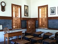
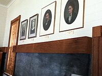
San Rafael City Schools is a school district headquartered in San Rafael, California, United States.

Dogtown is an unincorporated community in the rural West Marin region of coastal Marin County, California in the San Francisco Bay Area's North Bay. It lies at an elevation of 187 feet. With a population of 30, the town is located beside the Golden Gate National Recreation Area and Point Reyes National Seashore, in the Olema Valley west of the Bolinas Ridge mountain range.

Havilah is an unincorporated community in Kern County, California. It is located in the mountains between Walker Basin and the Kern River Valley, 5 miles (8.0 km) south-southwest of Bodfish at an elevation of 3,136 feet (956 m).
Marin County, California contains many public and private schools and a few higher education institutions.

The Miller Creek Elementary School District, formerly the Dixie School District, is a school district located in San Rafael, California that operates four schools in the northern portion of the city: Mary E. Silveira Elementary School in the Marinwood area, Vallecito Elementary School in the Terra Linda area, Lucas Valley Elementary School, and Miller Creek Middle School in the Marinwood area. All four are California Distinguished Schools.
Rancho San Pedro, Santa Margarita y Las Gallinas was a 21,679-acre (87.73 km2) Mexican land grant in present-day Marin County, California given in 1844 by Governor Manuel Micheltorena to Timothy Murphy. Las Gallinas means "the hens" in Spanish. The grant extended from east of Nicasio, California, south-east along the Lucas Valley, California, then along Miller Creek to Las Gallinas and the San Pablo Bay.
The Marin Museum of Contemporary Art (MarinMOCA) was founded in 2007 and is located in Novato, California, United States. The museum includes several galleries, over fifty artist studios, a classroom wing for studio art classes, and a museum store.