
The Dollart (German name) or Dollard (Dutch name) is a bay in the Wadden Sea between the northern Netherlands and Germany, on the west side of the estuary of the Ems river. Most of it dries at low tide. Many water birds feed there.
The Dollart (German name) or Dollard (Dutch name) is a bay in the Wadden Sea between the northern Netherlands and Germany, on the west side of the estuary of the Ems river. Most of it dries at low tide. Many water birds feed there.
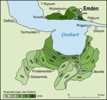
According to legend, the Dollart Bay was created by a catastrophic storm surge in 1277, [1] covering the district of Reiderland and large parts of the Oldambt district. The flood was rumoured to have caused 80,000 deaths. [2] The story, however, is not true and based on legend instead of facts. [3] [4] [5] The Dollart was created as a slow inundation over many centuries [6] which accumulated in a storm surge in 1509. The 1509 surge extended the Dollart, and flooded 30 more villages, [5] and by 1520 the Dollart had its largest extension. Between the 16th and the 20th centuries, two thirds of the drowned area was reclaimed again.
Nowadays the unembanked forelands have been declared world natural heritage, as they are a paradise for all kinds of birds and other aquatic species. [7]

The Netherlands and Germany do not agree on the exact course of the border through the bay, [8] yet they have agreed to disagree by signing a treaty in 1960, laying out mutual responsibilities. [9] Around 2011, the territorial dispute gained relevance with plans for the Borkum Riffgat offshore wind farm. [10] The question about use and administration of the territorial waters between 3 and 12 nautical miles (where the wind farm is located) was settled with another treaty in 2014 by defining a "line", while the border dispute itself remained unresolved. [11]

Drenthe is a province of the Netherlands located in the northeastern part of the country. It is bordered by Overijssel to the south, Friesland to the west, Groningen to the north, and the German state of Lower Saxony to the east. As of November 2019, Drenthe had a population of 493,449 and a total area of 2,680 km2 (1,030 sq mi).

The Ems is a river in northwestern Germany. It runs through the states of North Rhine-Westphalia and Lower Saxony, and discharges into the Dollart Bay which is part of the Wadden Sea. Its total length is 362.4 kilometres (225.2 mi). The state border between the Lower Saxon area of East Friesland (Germany) and the province of Groningen (Netherlands), whose exact course was the subject of a border dispute between Germany and the Netherlands, runs through the Ems estuary.

Bad Nieuweschans is a village in the north-eastern Netherlands on the border with Germany. It forms part of the municipality of Oldambt. Nieuweschans means "new fortification (sconce)". In 2009, the word Bad ("spa") was prefixed to the name of the village to promote it as a tourist destination.
Greater Netherlands is an irredentist concept which unites the Netherlands, Flanders, and sometimes Brussels. Additionally, a Greater Netherlands state may include the annexation of the French Westhoek, Suriname, formerly Dutch-speaking areas of Germany and France, or even the ethnically Dutch and/or Afrikaans-speaking parts of South Africa, though such variants are mostly limited to far-right groups. A related proposal is the Pan-Netherlands concept, which includes Wallonia and potentially also Luxembourg.

Beerta is a village and former municipality with a population of 2,205 in the municipality of Oldambt in the province of Groningen in the Netherlands. In the 20th century, Beerta was a communist stronghold. In 1933, the municipal council was dismissed by the government, and was ruled by a government commissioner until 1935. Between 1982 and 1990, Beerta was the only municipality with a communist mayor.
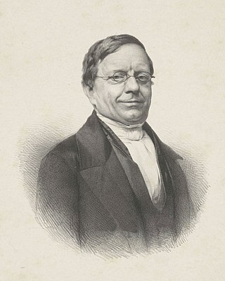
Abraham Jacob van der Aa was a Dutch writer best known for his dictionaries, one of notable people and the other of notable places in the Netherlands.

Oude Pekela is a town in the Dutch province of Groningen. It is located in the municipality of Pekela, about 5 km southwest of Winschoten. It was established to exploit the peat in the area. During the 19th century, it was known for its maritime transport. During the 20th century, Oude Pekela became the centre of the cardboard and potato starch industry.

Michaël Henricus Gertrudis (Michiel) van Kempen is a Dutch writer, art historian and literary critic. He has written novels, short stories, essays, travel literature and scenarios. He was the compiler of a huge range of anthologies of Dutch-Caribbean literature and wrote an extensive history of the literature of Suriname, in two volumes.

The Kingdom of the Netherlands, commonly known simply as the Netherlands, is a sovereign state consisting of a collection of constituent territories united under the monarch of the Netherlands, who functions as head of state. The realm is not a federation; it is a unitary monarchy with its largest subdivision, the eponymous Netherlands, predominantly located in Western Europe and with several smaller island territories located in the Caribbean.

Dutch–Finnish relations are foreign relations between the Netherlands and Finland. The Netherlands recognised Finland's independence on 28 January 1918. Diplomatic relations between them were established on 14 August 1918. The Netherlands has an embassy in Helsinki and consulates. Finland has an embassy in the Hague, an honorary consulate general in Amsterdam and other honorary consulates in Rotterdam and Terneuzen. Both countries are full members of the Council of Europe, the European Union and NATO. The Netherlands supported Finland's NATO membership during Finland's accession into NATO, which was finalized on 4 April 2023.

John of Nassau, German: Johann von Nassau, Dutch: Jan van Nassau was a clergyman from the House of Nassau. From 1267 to 1290 he was Bishop-Elect of the Bishopric of Utrecht as John I. He did not care much for his spiritual functions, and his government also failed due to his weak political and poor financial management. During his reign, the influence of the County of Holland in the Bishopric greatly increased. John's government was one of the worst the Bishopric had to endure; without talent and energy, slavishly surrendering to all sensual pleasures, it was never possible for him to maintain the inner peace, under which the Nedersticht in particular suffered greatly.
The Franco-Dutch treaty on Saint Martin border controls, sometimes shortened to the Franco-Dutch treaty and in full the Treaty between the Kingdom of the Netherlands and the French Republic on the control of persons entering Saint Martin through the airports, is a treaty between France and the Netherlands aimed at improving border controls at the two airports on the divided island of Saint Martin. The island is divided into French Saint-Martin and Dutch Sint Maarten.
The Convention on the association of the Netherlands Antilles with the European Economic Community is an international agreement amending the Treaty establishing the European Economic Community, with the aim of awarding OCT status to the Netherlands Antilles, which was a constituent country of the Kingdom of the Netherlands from 1954 until 2010. A full treaty revision was needed because Belgium, France, Germany, Italy, and Luxembourg wanted to add a protocol on the import of refined petroleum products from the Netherlands Antilles.
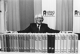
The Kingdom of the Netherlands During World War II is the standard reference on the history of the Netherlands during World War II. The series was written by Loe de Jong (1914–2005), director of the Dutch Institute for War Documentation, and was published between 1969 and 1991. The series contains 14 volumes, published in 29 parts. De Jong was commissioned to write the work in 1955 by the Ministry of Education, Culture and Science. The first volume appeared in 1969, and de Jong wrote his last in 1988. The final volume, containing critique and responses, appeared in 1991.

This is a timeline of Belgian history, including important legal and territorial changes and political events in Belgium and its predecessor states. To read about the background to these events, see History of Belgium. See also the list of Belgian monarchs.

A voorcompagnie (pre-company) is the name given to trading companies from the Republic of the Seven United Netherlands that traded in Asia between 1594 and 1602, before they merged to form the Dutch East India Company (VOC). The pre-companies were financed by merchants from the Northern Netherlands and rich immigrants from the Southern Netherlands. Because of the deadly competition, the government forced the smaller trading companies to unite and form the (United) East India Company. In its turn, it received the exclusive rights for the trade with Asia for the following 21 years.

Carel Hendrik Theodoor Bussemaker was a Dutch historian who held chairs in history at the University of Groningen and the University of Leiden.

Netherlands–Sweden relations are diplomatic relations between the kingdoms of Sweden and the Netherlands. Both countries are full members of the Council of Europe and the European Union. The Netherlands has an embassy in Stockholm, while Sweden has an embassy in The Hague. the Netherlands strongly supports Sweden's NATO membership.
Johan Willem Friso Wielenga is a Dutch contemporary historian.

Pekel A (also Pekel Aa; Dutch pronunciation:[ˈpeːkəlaː]) is a river in the Province of Groningen in the Netherlands. The villages of Oude Pekela and Nieuwe Pekela have been named after the river. The name translates to Brine (Pekel) River (A), and used to flow from the Dollart into a large raised bog. The Dollart was poldered from the 15th century until 1924, and the river now has its source at the confluence with the Westerwoldsche Aa at De Bult. The river was canalised and extended. The part from Oude Pekela to Stadskanaal was renamed Pekelderdiep. From 1599 until 1810, the area through which the river flowed, was a peat colony. In the 20th century, the Pekel A was a heavily polluted river, but it has been cleaned up since the 1970s.
dollart ems flood 1277.
| International | |
|---|---|
| National | |
53°17′N7°10′E / 53.29°N 7.16°E
Bays and former bays on the East Frisian Peninsula | ||
|---|---|---|
 | ||
| | This Netherlands-related article is a stub. You can help Wikipedia by expanding it. |