Domoni

Last updated
Domoni
Comoros location map.svg
Red pog.svg
Domoni
Location of Domoni on the island of Anjouan
Coordinates: 12°15′31″S44°31′49″E / 12.25861°S 44.53028°E / -12.25861; 44.53028
CountryFlag of the Comoros.svg  Comoros
Island Anjouan
Population
 (2012)
  Total16,276
Time zone UTC+3 (Eastern Africa Time)
Area code 269

Domoni (population 15,351) is the second largest city on the Comorian island of Anjouan in the Indian Ocean and is located on the east coast of the island. It was the capital of the island in the past while the present capital of Anjouan is Mutsamudu.

Contents

History

In ancient times, Domoni was the capital of the Nzwani sultans. [1] According to archaeological finds the town was established in the 12th century. [2] Domoni was already a flourishing centre for trade in the 15th century with Africa, Persia, Arab countries, and India. Archaeological artifacts indicated trades occurred with places as far away as Japan. [3] [4] Ibn Majid Ibn, a navigator who travelled in this area frequently and who had guided Vasco da Gama to India, confirmed this port as a major trading centre. [2] It was ruled in the 16th century by many chiefs (known as Feni) who controlled different parts of the island. Until the end of the 18th century, it was the capital of the Anjouan sultanate. It is home to a significant chirazienne (Shirazi) population who are descents of Sunni aristocratic immigrants from Shiraz, Persia, between the 14th and 18th centuries. [5]

Infighting among the chiefs of Anjouan resulted in their making an appeal to Europeans to broker a peace deal. Following this, Comoros initially became a French Protectorate in 1886, and in 1909, the French made it a part of their country. In 1975 the three islands formed a Republic of the Comoro Island. The first president of the Republic was Ahmed Abdallah, who hailed from Domoni and whose mausoleum is also located there. There were upheavals in the political dispensation in 1997 and again a rebellion in 2008 which was put down. [6]

Mwenye Fani, who took the name Abdallah I when he became Sultan, transferred the capital from Domoni to Mutsamudu. [7] Domoni is the birthplace of the first president of the Comorian Islands, Ahmed Abdallah, and of president Tadjidine ben Saïd Massonde. The third president was also resident of Domoni.[ citation needed ]

Geography and climate

Domoni is located on the east coast of Anjouan. Anjouan topographic map-fr.svg
Domoni is located on the east coast of Anjouan.

Domoni is located on the east coast of Anjouan, also known as the island of Nzwani. Domoni is one of the three major towns of the island; the other two are Bambao and Mutsamudu; the latter is the capital of the island, in the western Indian Ocean. It is connected by road to Domoni, about 10 miles (16 km) away. Ngadzale-Ahajo lies to the southwest and Limbe and Koni-Djojdo lie to the northwest. The Ajajo River flows into the sea to the south. [8] The airport on the island is in the village of Quani, 6 kilometres (3.7 mi) to the north of Mutsamdu. [9] [10] The population of the town is 15,351. [11] Bambao is 6 kilometres (3.7 mi) away to the north. [12] The old town is divided into three neighbourhoods: Hari ya muji, Maweni and Momoni.

The weather data in relation to temperature and rainfall is for the period 2000 to 2012. The maximum and minimum average temperatures recorded are 23 °C (73 °F) in December and 15 °C (59 °F) in August respectively. The average annual rainfall recorded is 1,059 millimetres (41.7 in) with a maximum of 264 millimetres (10.4 in) in December and a minimum of 23 millimetres (0.91 in) in July. [13]

Climate data for Domoni, Comoros
MonthJanFebMarAprMayJunJulAugSepOctNovDecYear
Record high °C (°F)22
(72)
21
(70)
20
(68)
21
(70)
19
(66)
22
(72)
20
(68)
19
(66)
18
(64)
21
(70)
21
(70)
23
(73)
23
(73)
Average low °C (°F)18
(64)
18
(64)
16
(61)
16
(61)
16
(61)
16
(61)
15
(59)
15
(59)
16
(61)
16
(61)
17
(63)
17
(63)
15.0
(59.0)
Average rainfall mm (inches)222
(8.7)
171
(6.7)
111
(4.4)
102
(4.0)
42
(1.7)
15
(0.6)
36
(1.4)
15
(0.6)
24
(0.9)
15
(0.6)
42
(1.7)
264
(10.4)
1,059
(41.7)
Source: World Weather Online [13]

Landmarks

Domoni in 1900. Domani-Anjouan 1930.jpg
Domoni in 1900.

Oil slicks and trash has affected the aesthetic quality of the seafront area. Protective walls built as fortifications around the town were meant to prevent attacks by Malagasy pirates. A tower in the wall fortifications is in a state of ruin. [11]

The first stone building in Domoni was built in the mid-13th century. The old houses built by Shirazis, who had migrated from Persia, are still seen in the town[ dubious ]. [12] The first mosques built were during the eleventh and twelfth centuries and reconstructed in the 13th century and enlarged substantially in the fourteenth and fifteenth centuries. One such mosque was the Mkiri wa Shirazi or the Shirazi Mosque. [14] The mosques in the town are built in stone masonry over raised foundations. [15] While most mosques have one mihrab oriented towards Mecca, the Shirazi Mosque is distinguished by having two mihrabs. The town's Friday mosque has the tallest minaret on the island, which is rectangular in shape. [16] The middle section of the town, known as Hari ya Muzhi, was the centre of activity from the 16th century onwards. It is the zone where the main plaza, the Friday mosque and a large number of mansions of the town are located. The mausoleum of president Ahmed Abdallah Abderemane, who was assassinated in 1989 by a presidential guard, is white in colour and includes four tall minarets. [11]

The town is known for its palaces and mansions of the 16th and 18th centuries, with a maze of houses with richly carved Swahili doors. The doors in mansions have lintels in stone relief work. [11] The stone buildings in the town often have a thatched roof over their terraces. [11]

Culture

The town is renowned for its high quality wooden carvings. Delicate embroidery is made by local craftsmen. [11] A colourful sight seen in the town is of women dabbing sandalwood paste on each other's faces while sitting on the staircase of the houses. [11] Domoni's culture is described in two works by academics from Kansas State University, Marriage in Domoni by Martin Ottenheimer and Music of the Comoro Islands Domoni by Martin and Harriet Ottenheimer. [17] Women create music by using coconut shells, gongs, and sticks, as well as playing the tari (frame drum); men play on different musical instruments such as the fumba, dori, and msindio (drums), along with the gabus (lute), mzumara (double reed), nkayamba (rattle), and ndzedze (box zither). [18] Wedding ceremonies feature a performance, a type of bullfight, evidence of the historical presence of the Portuguese at Domoni. [19]

The town has witnessed scenes of religious intolerance. Incidents of religious harassment of Christians in the premises of mosques in Domoni have been reported. In April 2001 leaders of the Christian community were questioned and threatened by Islamic religious groups. In one incident the father of a Christian leader had to pay a fine and the family live in exile from Domoni for a month. [20]

Related Research Articles

<span class="mw-page-title-main">Comoros</span> African island country in the Indian Ocean

The Comoros, officially the Union of the Comoros, is an independent country made up of three islands in Southeastern Africa, located at the northern end of the Mozambique Channel in the Indian Ocean. Its capital and largest city is Moroni. The religion of the majority of the population, and the official state religion, is Sunni Islam. Comoros proclaimed its independence from France on 6 July 1975. A member of the Arab League, it is the only country in the Arab world which is entirely in the Southern Hemisphere. It is a member state of the African Union, the Organisation internationale de la Francophonie, the Organisation of Islamic Cooperation, and the Indian Ocean Commission. The country has three official languages: Shikomori, French and Arabic.

The history of the Comoros extends to about 800–1000 AD when the archipelago was first inhabited. The Comoros have been inhabited by various groups throughout this time. France colonised the islands in the 19th century, and they became independent in 1975.

<span class="mw-page-title-main">Geography of the Comoros</span>

<span class="mw-page-title-main">Demographics of the Comoros</span>

The Comorians inhabiting Grande Comore, Anjouan, and Mohéli share African-Arab origins. Islam is the dominant religion, and Quranic schools for children reinforce its influence. Although Islamic culture is firmly established throughout, a small minority are Christian.

<span class="mw-page-title-main">Economy of the Comoros</span>

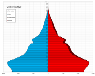
The economy of the Comoros is based on subsistence agriculture and fishing. Comoros has inadequate transportation links, a young and rapidly increasing population, and few natural resources. The low educational level of the labor force contributes to a subsistence level of economic activity, high unemployment, and a heavy dependence on foreign grants and technical assistance. The Comoros, with an estimated gross domestic product (GDP) per capita income of about $700, is among the world's poorest and least developed nations. Although the quality of the land differs from island to island, most of the widespread lava-encrusted soil formations are unsuited to agriculture. As a result, most of the inhabitants make their living from subsistence agriculture and fishing. Average wages in 2007 hover around $3–4 per day.

<span class="mw-page-title-main">Anjouan</span> Autonomous Island of the Union of the Comoros

Anjouan is an autonomous volcanic island in the Comoro Islands in the southwestern Indian Ocean, part of the Union of the Comoros. It is known in Shikomori as Ndzuani, Ndzuwani or Nzwani, and, until the early twentieth century when the name fell out of general use, in English as Johanna. Historically it was also called Hinzuan or Hanzoan.

<span class="mw-page-title-main">Moroni, Comoros</span> Capital of Comoros

Moroni is the largest city, federal capital, and seat of the government of the Union of the Comoros, a sovereign archipelago nation in the Indian Ocean. Moroni means "at the river". Moroni is the capital of the semi-autonomous island of Ngazidja, the largest of the three main islands of the republic. The city's estimated population in 2003 was 41,557 residents. Moroni, which lies along the Route Nationale 1, has a port and several mosques such as the Badjanani Mosque.

<span class="mw-page-title-main">Comoro Islands</span> Archipelago in the Indian Ocean

The Comoro Islands or Comoros form an archipelago of volcanic islands situated off the southeastern coast of Africa, to the east of Mozambique and northwest of Madagascar. The islands are politically divided between the Union of the Comoros, a sovereign country, and Mayotte, an Overseas Department of France.

<span class="mw-page-title-main">Ahmed Abdallah</span> President of the Comoros from 1978 to 1989

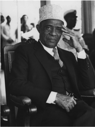
Ahmed Abdallah Abderemane was a top Comorian politician. He was a member of the French Senate from 1959 to 1973, and President of the Comoros from 25 October 1978 until his assassination in 1989.

<span class="mw-page-title-main">Islam in the Comoros</span> Religion in the Comoros

Islam is the largest religion in the Comoros. According to the 2006 estimate by the U.S. Department of State, roughly 98% of the population in the Comoros is Muslim. Virtually all Muslims in the Comoros are Sunni belonging to Shafi'i school of jurisprudence. Most adherents are Arab-Swahili, but there are also people of Indian, largely Gujarati, descent.

<span class="mw-page-title-main">Mutsamudu</span> Place in Anjouan, Comoros

Mutsamudu is the second-largest city in the Comoros. It is also the capital and largest city on the island of Anjouan as well the former home of former Comorian president Ahmed Abdallah Mohamed Sambi. It now houses a deep water port, an ancient citadel, and narrow streets with many shops and small crafts. The population in 2010 stood at 25,471.

<span class="mw-page-title-main">Ahmed Abdallah Mohamed Sambi</span>

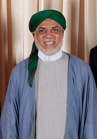
Sayyid Ahmed Abdallah Mohamed Sambi is a Comorian Islamic leader and politician, and former President of Comoros. He is popularly known as 'Ayatollah'. After easily winning the 14 May 2006 presidential election with 58.02% of the national vote, Sambi was inaugurated as President of the Union of the Comoros on 26 May 2006. It was the first peaceful transfer of power in the history of the Comoros.

The Shirazis of the Comoros, 138,000 people with Iranian heritage, are one of the largest ethnic group inhabiting the archipelago nation of Comoros near the east African coast and they represent 17% of the total population of the Comoros. Their origins are linked to Shiraz and the southwestern coastal region of Persia. 89,000 people or 11% of the population from the Comoros have Southeast Asian ancestry. The Shirazi people are notable for helping establish Sunni Islam in Comoros, and the wealth they accumulated from trading commodities and slaves.

Health in the Comoros continues to face public health problems characteristic of developing countries. After Comoros's independence in 1975, the French withdrew their medical teams, leaving the three islands' already rudimentary health care system in a state of severe crisis. French assistance was eventually resumed, and other nations also contributed medical assistance to the young republic.

<span class="mw-page-title-main">2008 invasion of Anjouan</span> Military operation in the Comoros islands

The invasion of Anjouan, on March 25, 2008, was an amphibious assault led by the Comoros, backed by African Union (AU) forces, including troops from Sudan, Tanzania, Senegal, along with logistical support from Libya and France. The objective of the invasion was to topple Colonel Mohamed Bacar's leadership in Anjouan, an island in the Union of Comoros, when he refused to step down after a disputed 2007 election, in defiance of the federal government and the AU. The Comoros archipelago in the Indian Ocean has had a fractious history since its independence from France in 1975, experiencing more than 20 coups or attempted coups.

The Shirazi people, also known as Mbwera, are a Bantu ethnic group inhabiting the Swahili coast and the nearby Indian ocean islands. They are particularly concentrated on the islands of Zanzibar, Pemba and Comoros.

<span class="mw-page-title-main">Languages of the Comoros</span>

The official languages of the Comoros are Comorian, French and Arabic, as recognized under its 2001 constitution. Although each language holds equal recognition under the constitution, language use varies across Comorian society. Unofficial minority languages such as Malagasy and Swahili are also present on the island with limited usage. According to Harriet Joseph Ottenheimer, a professor of anthropology at Kansas State university, the linguistic diversity of the Comoros is the result of its rich history as part of the Indian maritime trade routes and its periods of Malagasy and French colonial rule.

<span class="mw-page-title-main">1997 Anjouan independence referendum</span>

An independence referendum was held on Anjouan, an island in the Comoros, on 26 October 1997. Over 99% of voters voted in favour of independence. However, the vote was not recognised and the island returned to the control of the Comorian government in 2001.

References

  1. Ottenheimer 1994, p. 25.
  2. 1 2 "Comoro Islands". Kansa State University.
  3. Wane 2009, p. 23.
  4. "Travelin Moroni Comoros Culture". africatravelling.net.
  5. Ottenheimer 1985, p. 2.
  6. "Nzwani (Anjouan)". Kansas State University.
  7. Ottenheimer 1994, p. 9.
  8. Google maps, accessed 29 March 2015.
  9. Andrew et al. 2008, p. 251.
  10. Knight 1854, p. 2.
  11. 1 2 3 4 5 6 7 Andrew et al. 2008, p. 254.
  12. 1 2 Penrith & Penrith 2000, p. 274.
  13. 1 2 "Domoni Monthly Climate Average, Comoros". World Weather Online.
  14. Insoll 2003, p. 193.
  15. Ottenheimer 1985, p. 25.
  16. Ottenheimer 1985, p. 30.
  17. Ottenheimer 1994, p. v.
  18. Anderson, Lois Ann (1987). "Music of the Comoro Islands: Domoni by Harriet Ottenheimer; Martin Ottenheimer; Mark Pevar". Ethnomusicology. 31 (3): 528–530. doi:10.2307/851677. JSTOR   851677.
  19. Arens 1976, p. 233.
  20. Lipton 2002, p. 31.

Bibliography

12°15′31″S44°31′49″E / 12.25861°S 44.53028°E / -12.25861; 44.53028