Related Research Articles

Mount Baker, also known as Koma Kulshan or simply Kulshan, is a 10,781 ft (3,286 m) active glacier-covered andesitic stratovolcano in the Cascade Volcanic Arc and the North Cascades of Washington in the United States. Mount Baker has the second-most thermally active crater in the Cascade Range after Mount St. Helens. About 30 miles (48 km) due east of the city of Bellingham, Whatcom County, Mount Baker is the youngest volcano in the Mount Baker volcanic field. While volcanism has persisted here for some 1.5 million years, the current volcanic cone is likely no more than 140,000 years old, and possibly no older than 80–90,000 years. Older volcanic edifices have mostly eroded away due to glaciation.

An oil platform is a large structure with facilities to extract and process petroleum and natural gas that lie in rock formations beneath the seabed. Many oil platforms will also have facilities to accommodate the workers, although it is also common to have a separate accommodation platform bridge linked to the production platform. Most commonly, oil platforms engage in activities on the continental shelf, though they can also be used in lakes, inshore waters, and inland seas. Depending on the circumstances, the platform may be fixed to the ocean floor, consist of an artificial island, or float. In some arrangements the main facility may have storage facilities for the processed oil. Remote subsea wells may also be connected to a platform by flow lines and by umbilical connections. These sub-sea facilities may include of one or more subsea wells or manifold centres for multiple wells.
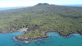
Rangitoto Island is a volcanic island in the Hauraki Gulf near Auckland, New Zealand. The 5.5 km (3.4 mi) wide island is a symmetrical shield volcano cone capped by central scoria cones, reaching a height of 260 m (850 ft). Rangitoto is the youngest and largest of the approximately 50 volcanoes of the Auckland volcanic field, having erupted in two phases about 620 and 600 years ago and covering an area of 2,311 ha. It is separated from the mainland of Auckland's North Shore by the Rangitoto Channel. Since World War II, it has been linked by a causeway to the much older, non-volcanic Motutapu Island.
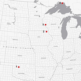
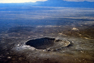
Ames crater is a meteorite crater (astrobleme) in Major County, Oklahoma, United States. Ames, Oklahoma is near the center of the structure, which is 30 miles (48 km) southwest of Enid, Oklahoma. Buried under a thick layer of sediment, it was not discovered until 1991. Subsequent drilling within the crater found a large amount of oil and gas. It is one of the largest of six meteor craters associated with oil-producing formations in the United States.

The Panmure Basin, also sometimes known as the Panmure Lagoon, is a tidal estuary within a volcanic crater or maar in New Zealand's Auckland volcanic field. It is located to the south of Panmure town centre.

The Sidoarjo mud flow is the result of an erupting mud volcano in the subdistrict of Porong, Sidoarjo in East Java, Indonesia that has been in eruption since May 2006. It is the biggest mud volcano in the world; responsibility for the disaster was assigned to the blowout of a natural gas well drilled by PT Lapindo Brantas, although company officials contend it was caused by a very distant earthquake that occurred in a different province.

The Midcontinent Rift System (MRS) or Keweenawan Rift is a 2,000 km (1,200 mi) long geological rift in the center of the North American continent and south-central part of the North American plate. It formed when the continent's core, the North American craton, began to split apart during the Mesoproterozoic era of the Precambrian, about 1.1 billion years ago. The rift failed, leaving behind thick layers of igneous rock that are exposed in its northern reaches, but buried beneath later sedimentary formations along most of its western and eastern arms. Those arms meet at Lake Superior, which is contained within the rift valley. The lake's north shore in Ontario and Minnesota defines the northern arc of the rift. From the lake, the rift's eastern arm trends south to central lower Michigan, and possibly into Indiana, Ohio, Kentucky, Tennessee, and Alabama. The western arm runs from Lake Superior southwest through portions of Wisconsin, Minnesota, Iowa, and Nebraska to northeastern Kansas, and possibly into Oklahoma.
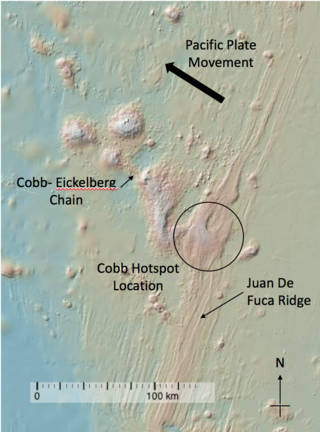
The Cobb hotspot is a marine volcanic hotspot at, which is 460 km (290 mi) west of Oregon and Washington, North America, in the Pacific Ocean. Over geologic time, the Earth's surface has migrated with respect to the hotspot through plate tectonics, creating the Cobb–Eickelberg Seamount chain. The hotspot is currently collocated with the Juan de Fuca Ridge.
Jackson Volcano is an extinct volcano 2,900 feet (880 m) beneath the city of Jackson, Mississippi, under the Mississippi Coliseum. The uplifted terrain around the volcano forms the Jackson Dome, an area of dense rock clearly noticeable in local gravity measurements. E.W. Hilgard published his theory of an anticline beneath Jackson in 1860 due to his observations of surface strata. The dome contains relatively pure carbon dioxide which is used in oil production in Gulf Coast oil fields. The noble gas data suggests mantle origins with a date of 70 million years for the Jackson Dome intrusion. Geologists have evidence of repeated uplifts accompanied by dike intrusions and volcanic extrusions, erosion, and sedimentation with one coral reef having developed during a submergence. Much of the oil at the crest of the dome volatilized during a late uplift, but oil production wells numbered over a hundred in 1934.

Tharsis Tholus is an intermediate-sized shield volcano located in the eastern Tharsis region of the planet Mars. The volcano was discovered by the Mariner 9 spacecraft in 1972 and originally given the informal name Volcano 7. In 1973, the International Astronomical Union (IAU) officially designated it Tharsis Tholus. In planetary geology, tholus is the term for a small domical mountain, usually a volcano.

Offshore oil and gas in the Gulf of Mexico is a major source of oil and natural gas in the United States. The western and central Gulf of Mexico, which includes offshore Texas, Louisiana, Mississippi, and Alabama, is one of the major petroleum-producing areas of the United States. Oil production from US federal waters in the Gulf of Mexico reached an all-time annual high of 1.65 million barrels per day in 2017. Oil production is expected to continue the upward trend in 2018 and 2019, based on ten new oil fields which are planned to start production in those years. According to the Energy Information Administration, "Gulf of Mexico federal offshore oil production accounts for 15% of total U.S. crude oil production and federal offshore natural gas production in the Gulf accounts for 5% of total U.S. dry production."

Esther Applin was an American geologist and paleontologist. She completed her undergraduate degree in 1919 from the University of California, Berkeley. Later, she completed a master's degree which was focused on microfossils. She was a leading figure in the use of microfossils to determine the age of rock formation for use in oil exploration in the Gulf of Mexico region. Her job was to examine microfossils collected in drill holes to determine the age of the rock into which the company was drilling. Applin's discoveries were crucial to successful drilling operations across the entire oil industry. Additionally, her contribution to geology and the study of micropaleontology, put women geologists on the map, and was pivotal in earning them respect in the field.

The Campanian Ignimbrite eruption was a major volcanic eruption in the Mediterranean during the late Quaternary, classified 7 on the Volcanic Explosivity Index (VEI). The event has been attributed to the Archiflegreo volcano, the 13-kilometre-wide (8.1 mi) caldera of the Phlegraean Fields, located 20 km (12 mi) west of Mount Vesuvius under the western outskirts of the city of Naples and the Gulf of Pozzuoli, Italy. Estimates of the date and magnitude of the eruption(s), and the amount of ejected material have varied considerably during several centuries the site has been studied. This applies to most significant volcanic events that originated in the Campanian Plain, as it is one of the most complex volcanic structures in the world. However, continued research, advancing methods, and accumulation of volcanological, geochronological, and geochemical data have improved the dates' accuracy.
Midnight Volcano is believed to be a buried extinct volcano in southern Humphreys County, Mississippi. It is named after the nearby town of Midnight, Mississippi. During the time it was active, Midnight Volcano may have been a volcanic island in the Mississippi Embayment.
The Salton Buttes are a group of volcanoes in California, on the Salton Sea. They consist of a 7-kilometer (4.3 mi)-long row of five lava domes, named Mullet Island, North Red Hill, Obsidian Butte, Rock Hill and South Red Hill. They are closely associated with a fumarolic field and a geothermal field, and there is evidence of buried volcanoes underground. In pre-modern times Obsidian Butte was an important regional source of obsidian.

The Rarotonga hotspot is a volcanic hotspot in the southern Pacific Ocean. The hotspot is claimed to be responsible for the formation of Rarotonga and some volcanics of Aitutaki but an alternative explanation for these islands most recent volcanics has not be ruled out. Recently alternatives to hotspot activity have been offered for several other intra-plate volcanoes that may have been associated with the Rarotonga hotspot hypothesis.
The geology of Nicaragua includes Paleozoic crystalline basement rocks, Mesozoic intrusive igneous rocks and sedimentary rocks spanning the Cretaceous to the Pleistocene. Volcanoes erupted in the Paleogene and within the last 2.5 million years of the Quaternary, due to the subduction of the Cocos Plate, which drives melting and magma creation. Many of these volcanoes are in the Nicaraguan Depression paralleled by the northwest-trending Middle America Trench which marks the Caribbean-Cocos plate boundary. Almost all the rocks in Nicaragua originated as dominantly felsic continental crust, unlike other areas in the region which include stranded sections of mafic oceanic crust. Structural geologists have grouped all the rock units as the Chortis Block.
South Arch volcanic field is an underwater volcanic field south of Hawaiʻi Island. It was active during the last 10,000 years, and covers an area of 35 by 50 kilometres at a depth of 4,950 metres (16,240 ft).

North Arch volcanic field is an underwater volcanic field north of Oahu, Hawaii. It covers an area of about 25,000 square kilometres (9,700 sq mi) and consists of large expanses of alkali basalt, basanite and nephelinite that form extensive lava flows and volcanic cones. Some lava flows are longer than 100 kilometres (62 mi).
A crater is a landform consisting of a hole or depression on a planetary surface, usually caused either by an object hitting the surface, or by geological activity on the planet. A crater has classically been described as: "a bowl-shaped pit that is formed by a volcano, an explosion, or a meteorite impact". On Earth, craters are "generally the result of volcanic eruptions", while "meteorite impact craters are common on the Moon, but are rare on Earth".
References
- ↑ "Abstract: DOOR POINT: VOLCANO IN THE GULF (2015 GSA Annual Meeting in Baltimore, Maryland, USA (1-4 November 2015))". gsa.confex.com. Retrieved 2018-06-08.
- ↑ McMichael, Jules Braunstein , Claude E. (1976). "Abstract: Door Point: A Buried Volcano in Southeast Louisiana" (PDF). 26.
{{cite journal}}: Cite journal requires|journal=(help)
| | This volcanology article is a stub. You can help Wikipedia by expanding it. |