
Lodi is an unincorporated community in northern Marion County, Texas, United States. Its elevation is 253 feet. It has a post office with the ZIP code 75564. The only business in Lodi, Texas is Lodi Drilling & Service Company Inc.
Myra is an unincorporated community in western Cooke County, Texas, United States. It lies just off U.S. Route 82 west of the city of Gainesville, the county seat of Cooke County. Its elevation is 935 feet (285 m). it had a post office, with the ZIP code 76253 until early 2013. It is now closed.
Donie is an unincorporated community in southern Freestone County, Texas, United States. It lies along State Highway 164 south of the city of Fairfield, the county seat of Freestone County. Its elevation is 489 feet (149 m). Although Donie is unincorporated, it has a post office, with the ZIP code of 75838.
Flint is an unincorporated community in southeastern Smith County, Texas, United States. It lies along FM 2493 south of the city of Tyler, the county seat of Smith County. Its elevation is 522 feet (159 m). Although Flint is unincorporated, it has a post office, with the ZIP code of 75762.
Hillister is an unincorporated community in southern Tyler County, Texas, United States. It lies along the concurrent U.S. Routes 69 and 287 south of the town of Woodville, the county seat of Tyler County. Although Hillister is unincorporated, it has a post office, with the ZIP code of 77624.
Cookville is an unincorporated community in eastern Titus County, Texas, United States. It lies along U.S. Route 67 east of the city of Mount Pleasant, the county seat of Titus County. Its elevation is 433 feet (132 m). Although Cookville is unincorporated, it has a post office, with the ZIP code of 75558, located at the junction of US 67 and Farm to Market Road 1000.
Selman City is an unincorporated community in western Rusk County, Texas, United States. It lies along State Highway 64 west of the city of Henderson, the county seat of Rusk County. Its elevation is 407 feet (124 m). Although Selman City is unincorporated, it has a post office, with the ZIP code of 75689.
Knott is an unincorporated community in northwestern Howard County, Texas, United States. It lies along FM 846 northwest of the city of Big Spring, the county seat of Howard County. Its elevation is 2,612 feet (796 m). Although Knott is unincorporated, it has a post office, with the ZIP code of 79748.
Maryneal is an unincorporated community in southern Nolan County, Texas, United States. It lies along FM 608 south of the city of Sweetwater, the county seat of Nolan County. Its elevation is 2,566 feet (782 m). Although Maryneal is unincorporated, it has a post office, with the ZIP code of 79535; the ZCTA for ZIP Code 79535 had a population of 181 at the 2000 census.
Nolan is an unincorporated community in southeastern Nolan County, Texas, United States. It lies along FM 126 southeast of the city of Sweetwater, the county seat of Nolan County. Its elevation is 2,493 feet (760 m), which happens to be the average elevation of the United States. Although Nolan is unincorporated, it has a post office, with the ZIP code of 79537; the ZCTA for ZIP Code 79537 had a population of 94 at the 2000 census.
Tennyson is an unincorporated community in southeastern Coke County, Texas, United States. It lies along U.S. Route 277 southeast of the city of Robert Lee, the county seat of Coke County. Its elevation is 1,883 ft (574 m). Although Tennyson is unincorporated, it has a post office, with the ZIP code of 76953; the ZCTA for ZIP code 76953 had a population of 64 at the 2000 census.
Summerfield is an unincorporated community in northwestern Castro County, Texas, United States. It lies along U.S. Route 60 northwest of the city of Dimmitt, the county seat of Castro County. Its elevation is 3,937 feet (1,200 m). Although Summerfield is unincorporated, it has a post office, with the ZIP code of 79085.
Aiken is an unincorporated community in western Floyd County, Texas, United States. It lies along U.S. Route 70 north of the city of Floydada, the county seat of Floyd County. Its elevation is 3,300 feet (1,006 m). Although Aiken is unincorporated, it has a post office, with the ZIP code of 79221.
Vancourt is an unincorporated community in eastern Tom Green County, Texas, United States. It lies along U.S. Route 87 east of the city of San Angelo, the county seat of Tom Green County. Its elevation is 1,867 feet (569 m). Although Vancourt is unincorporated, it has a post office, with the ZIP code of 76955; the ZCTA for ZIP Code 76955 had a population of 108 at the 2000 census.
Mereta is an unincorporated community in eastern Tom Green County, Texas, United States. It lies along local roads east of the city of San Angelo, the county seat of Tom Green County. Its elevation is 1,755 feet (535 m). Although Mereta is unincorporated, it has a post office, with the ZIP code of 76940; the ZCTA for ZIP Code 76940 had a population of 138 at the 2000 census.

Waring is an unincorporated community in northwestern Kendall County, Texas, United States. It lies along local roads and the Guadalupe River, northwest of the city of Boerne, the county seat of Kendall County. Its elevation is 1,345 feet (410 m). Although Waring is unincorporated, it has a post office, with the ZIP code of 78074; the ZCTA for ZIP Code 78074 had a population of 59 at the 2000 census. The community is part of the San Antonio Metropolitan Statistical Area.

Kendalia is an unincorporated community in northeastern Kendall County, Texas, United States. It is part of the Texas-German belt.
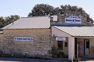
Bergheim is an unincorporated community in eastern Kendall County, Texas, United States known for its German-Texan culture and heritage. It lies along State Highway 46 east of the city of Boerne, the county seat of Kendall County. Its elevation is 1,437 feet (438 m). Although Bergheim is unincorporated, it has a post office, with the ZIP code of 78004; the ZCTA for ZIP Code 78004, consisting mostly of rural land, had a population of 1,183 at the 2010 census. The community is part of the San Antonio metropolitan statistical area. Bergheim is still a predominantly a ranching and agricultural community.

Thomaston is an unincorporated community in southeastern DeWitt County, Texas, United States. It lies along U.S. Route 87 southeast of the city of Cuero, the county seat of DeWitt County. Its elevation is 161 feet (49 m). Although Thomaston is unincorporated, it has a post office, with the ZIP code of 77989.
Lelia Lake is an unincorporated community in central Donley County, Texas, United States. It lies along U.S. Route 287 southeast of the city of Clarendon, the county seat of Donley County. Its elevation is 2,592 feet (790 m). Although Lelia Lake is unincorporated, it has a post office, with the ZIP code of 79240; the ZCTA for ZIP code 79240 had a population of 101 at the 2000 census.


