This article relies largely or entirely on a single source .(November 2020) |
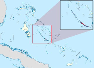
Dove Cay is an island in the Bahamas. It is located in the vicinity of Long Island, Bahamas. [1] It is 1.07km long. [1]
This article relies largely or entirely on a single source .(November 2020) |
Dove Cay is an island in the Bahamas. It is located in the vicinity of Long Island, Bahamas. [1] It is 1.07km long. [1]

The Bahamas are a group of about 700 islands and cays in the western Atlantic Ocean, of which only between 30 and 40 are inhabited. The largest of the islands is Andros Island, located north of Cuba and 200 kilometres southeast of Florida. The Bimini islands are to its northwest. To the North is the island of Grand Bahama, home to the second-largest city in the country, Freeport. The island of Great Abaco is to its east. In the far south is the island of Great Inagua, the second-largest island in the country. Other notable islands include Eleuthera, Cat Island, San Salvador Island, Acklins, Crooked Island, and Mayaguana. Nassau is the capital and largest city, located on New Providence. The islands have a tropical savannah climate, moderated by the Gulf Stream. The total size is 13,878 km2 (5,358 sq mi). Due to the many widespread islands it has the 41st largest Exclusive Economic Zone of 654,715 km2 (252,787 sq mi).

The Arctic Archipelago, also known as the Canadian Arctic Archipelago, is an archipelago lying to the north of the Canadian continental mainland, excluding Greenland and Iceland.
Raft Island is a private island and CDP located near the Pierce County community of Rosedale, Washington, United States. Gig Harbor, Washington is the nearest incorporated town, although unincorporated Artondale is much closer. The island features approximately 200 homes on 160 acres. All of these homes are served through the Gig Harbor post office.

Exuma is a district of The Bahamas, consisting of over 365 islands and cays.

Sutwik Island is a 14-mile-long (22.5 km) island in the U.S. state of Alaska, located at 56°33′26″N157°10′09″W off the Alaska Peninsula, east of Chignik Bay. It is part of Lake and Peninsula Borough and the Alaska Peninsula unit of the Alaska Maritime National Wildlife Refuge.

Cay Sal Bank is the third largest and the westernmost of the Bahama Banks. It is located between 23º27'N - 24º10'N and 079º25'W – 080º35'W. In a geographical sense, it is separate from the Bahamas proper as it is much closer to Cuba than to the closest Bahamian island. It is separated by Santaren Channel from the Great Bahama Bank, the western rim of which is 50 km (31 mi) to the east. The Straits of Florida separate it from the United States mainland and the Florida Keys.

Cropseyville is a hamlet in Rensselaer County, New York, United States. It comprises the ZIP code of 12052. It is located east of the city of Troy, in the town of Brunswick.
Aukum, officially Mount Aukum, is an unincorporated community in El Dorado County, California. It is located 1 mi (1.6 km) northeast of River Pines, 1.2 mi (1.9 km) south of Mount Aukum and 8.5 mi (13.7 km) northeast of Plymouth, at an elevation of 2,155 feet (657 m). The ZIP code is 95656.
Featherstone Fork is an unincorporated community in Caroline County, in the U.S. state of Virginia.
Mollendal is an uninhabited part of Virgin Islands National Park on the island of Saint John in the United States Virgin Islands. The L'Esperance Trail passes through this area.
Opekiska was an unincorporated community located in Monongalia County, West Virginia, United States. The Opekiska Post Office is no longer open.
Pine Lake may refer to two separate lakes in Chisago County, Minnesota
Pinnickinnick Mountain is a summit in West Virginia, in the United States. With an elevation of 1,453 feet (443 m), Pinnickinnick Mountain is the 774th highest summit in the state of West Virginia.
Hubbells is an unincorporated community in Butler County, in the U.S. state of Missouri.
Swift is an extinct town in Pemiscot County, in the U.S. state of Missouri. The GNIS classifies it as a populated place.
Winkler is an unincorporated community in southeast Phelps County, in the U.S. state of Missouri. The community is located on Missouri Route 68, thirteen miles north of Salem and eleven miles south of St. James.
Milton is an unincorporated community in Randolph County, in the U.S. state of Missouri. An old variant name was "Firth".
The Salt Water Barrier was a proposed project on the estuary of the Delaware River, which was projected in the late 1950s to convert the lower reaches of the Delaware into a freshwater lake. The barrier was proposed as a 30-foot (9.1 m) high dam near New Castle, Delaware, 53,300 feet (16,200 m) long, equipped with locks for the passage of shipping to Wilmington and Philadelphia. A study for the project was authorized by Congress in 1958, with engineering evaluations and public hearings by the U.S. Army Corps of Engineers. The prime purpose of the project was to develop the lower river as a source of drinking water for communities along the lower river. Objections to the barrier included concerns about the oyster industry, shipping constraints, increased shoaling, ice formation, and most importantly, the possibility of trapping pollutants above the barrier. The project was found to be technically feasible, but not economically practical. It was not included in the final Delaware River Basin Report of 1962, which proposed reservoirs higher in the Delaware River basin, and no further action was taken.

Stella Maris is a resort town in Long Island, the Bahamas. It was established during 1963. Stella Maris has a year-round population estimated at 80 people.