Dover, Vermont

Last updated
Dover, Vermont
Dover Town Hall, Dover VT.jpg
Dover Town Hall
Dover vt highlight.png
Dover, Vermont
Usa edcp location map.svg
Red pog.svg
Dover, Vermont
Location in the United States
Coordinates: 42°57′26″N72°51′9″W / 42.95722°N 72.85250°W / 42.95722; -72.85250 Coordinates: 42°57′26″N72°51′9″W / 42.95722°N 72.85250°W / 42.95722; -72.85250
Country United States
State Vermont
County Windham
Area
  Total35.3 sq mi (91.4 km2)
  Land35.3 sq mi (91.4 km2)
  Water0.0 sq mi (0.0 km2)
Elevation
1,978 ft (603 m)
Population
 (2020)
  Total1,798
  Density51/sq mi (19.7/km2)
Time zone UTC-5 (Eastern (EST))
  Summer (DST) UTC-4 (EDT)
ZIP code
05341, 05351, 05355, 05356, 05363
Area code 802
FIPS code 50-17875 [1]
GNIS feature ID1462083 [2]
Website https://www.doververmont.com/

Dover is a town in Windham County, Vermont, United States. The population was 1,798 at the 2020 census. [3] It is famed for being the location of the Mount Snow ski area.

Contents

Geography

According to the United States Census Bureau, the town has a total area of 35.3 square miles (91.4 km2), all land. The Rock River and the North Branch of the Deerfield River have their sources in the town. [4]

Climate

This climatic region is typified by large seasonal temperature differences, with warm to hot (and often humid) summers and cold (sometimes severely cold) winters. According to the Köppen Climate Classification system, Dover has a humid continental climate, abbreviated "Dfb" on climate maps. [5]

Demographics

Historical population
CensusPop.Note
1810 859
1820 829−3.5%
1830 8310.2%
1840 729−12.3%
1850 709−2.7%
1860 650−8.3%
1870 635−2.3%
1880 621−2.2%
1890 524−15.6%
1900 503−4.0%
1910 377−25.0%
1920 3852.1%
1930 278−27.8%
1940 244−12.2%
1950 2523.3%
1960 37046.8%
1970 55550.0%
1980 66620.0%
1990 99449.2%
2000 1,41041.9%
2010 1,124−20.3%
2020 1,79860.0%
U.S. Decennial Census [6]

At the 2000 census there were 1,410 people, 611 households, and 372 families in the town. The population density was 39.9 people per square mile (15.4/km2). There were 2,749 housing units at an average density of 77.9 per square mile (30.1/km2). The racial makeup of the town was 97.66% White, 0.07% African American, 1.06% Asian, 0.35% from other races, and 0.85% from two or more races. Hispanic or Latino of any race were 1.21%. [1]

Of the 611 households 27.5% had children under the age of 18 living with them, 51.4% were married couples living together, 6.2% had a female householder with no husband present, and 39.1% were non-families. 29.3% of households were one person and 5.6% were one person aged 65 or older. The average household size was 2.31 and the average family size was 2.86.

The age distribution was 22.2% under the age of 18, 5.8% from 18 to 24, 29.8% from 25 to 44, 31.1% from 45 to 64, and 11.1% 65 or older. The median age was 41 years. For every 100 females, there were 107.7 males. For every 100 females age 18 and over, there were 107.8 males.

The median household income was $43,824 and the median family income was $49,688. Males had a median income of $31,351 versus $26,985 for females. The per capita income for the town was $23,485. About 6.9% of families and 10.0% of the population were below the poverty line, including 18.6% of those under age 18 and 3.2% of those age 65 or over.

Notable people

See also

Related Research Articles

<span class="mw-page-title-main">Windham County, Vermont</span> County in Vermont, United States

Windham County is a county located in the U.S. state of Vermont. As of the 2020 census, the population was 45,905. The shire town is Newfane, and the largest municipality is the town of Brattleboro.

<span class="mw-page-title-main">Guildhall, Vermont</span> Town in Vermont, United States

Guildhall is a town in and the shire town of Essex County, Vermont. As of the 2020 census, the population was 262. According to a large sign in the town center, it is the only town in the world so named. The name derives from a meeting house on the square called the Guildhall.

<span class="mw-page-title-main">Morristown, Vermont</span> Town in Vermont, United States

Morristown is a town in Lamoille County, Vermont, United States. As of the 2020 census, the population was 5,434. Morristown is the largest town by population in Lamoille County, and its central village of Morrisville serves as the county's main commercial center.

<span class="mw-page-title-main">Chittenden, Vermont</span> Town in Vermont, United States

Chittenden is a town in Rutland County, Vermont, United States. The population was 1,237 at the 2020 census.

<span class="mw-page-title-main">Brookline, Vermont</span> Town in Vermont, United States

Brookline is a town in Windham County, Vermont, United States. The population was 540 at the 2020 census.

<span class="mw-page-title-main">Jacksonville, Vermont</span> Village in Vermont, United States

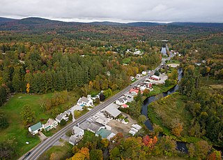
Jacksonville is a village in the town of Whitingham, Windham County, Vermont, United States. The population was 213 at the 2020 census.

<span class="mw-page-title-main">Jamaica, Vermont</span> Town in Vermont, United States

Jamaica is a town in Windham County, Vermont, United States. The population was 1,005 at the 2020 census. The town includes the villages of Jamaica, East Jamaica and Rawsonville.

<span class="mw-page-title-main">Londonderry, Vermont</span> Town in Vermont, United States

Londonderry is a town in Windham County, Vermont, United States. It is bounded on the north by Landgrove and Weston, on the east by Windham, on the south by Jamaica and on the west by Winhall and Landgrove. The population was 1,919 in the 2020 census. The town contains the villages of Londonderry and South Londonderry.

<span class="mw-page-title-main">Vernon, Vermont</span> Town in Vermont, United States

Vernon is a town in Windham County, Vermont, in the United States. The population was 2,192 at the 2020 census. Vernon is the site of the now-defunct Vermont Yankee, the state of Vermont's only nuclear power plant, which closed in December 2014.

<span class="mw-page-title-main">Wardsboro, Vermont</span> Town in Vermont, United States

Wardsboro is a town in Windham County, Vermont, United States. The population was 869 at the 2020 census. The town includes the villages of Wardsboro, Wardsboro Center, West Wardsboro and South Wardsboro.

<span class="mw-page-title-main">Whitingham, Vermont</span> Town in Vermont, United States

Whitingham is a town in Windham County, Vermont, United States. The town was named for Nathan Whiting, a landholder. The population was 1,344 at the 2020 census. Whitingham is the birthplace of Brigham Young, the second president of the Church of Jesus Christ of Latter-day Saints and founder of Salt Lake City, Utah. Its village center, census-designated place, is also listed on the National Register of Historic Places as the Whitingham Village Historic District.

<span class="mw-page-title-main">Windham, Vermont</span> Town in Vermont, United States

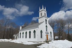
Windham is a town in Windham County, Vermont, United States. The population was 449 at the 2020 census. The town center village is designated as the Windham Village Historic District.

<span class="mw-page-title-main">Burnsville, West Virginia</span> Town in West Virginia, United States

Burnsville is a town in Braxton County, West Virginia, United States, at the confluence of the Little Kanawha River and Saltlick Creek. The population was 401 at the 2020 census. Burnsville was incorporated in 1902 by the Circuit Court and named for Captain John Burns who operated the first sawmill in that section of the state and who established the town shortly after the close of the American Civil War. It was named "All West Virginia City" in 1976.

<span class="mw-page-title-main">Jane Lew, West Virginia</span> Town in West Virginia, United States

Jane Lew is a town in Lewis County, West Virginia, United States. The population was 409 at the time of the 2020 census.

<span class="mw-page-title-main">Man, West Virginia</span> Town in West Virginia, United States

Man is a town in Logan County, West Virginia, United States. The population was 759 at the 2010 census. The town is located along the Guyandotte River at the mouth of Buffalo Creek, which was the site of the 1972 Buffalo Creek Flood following a dam collapse. The name of the town reportedly derives from the last syllable of the surname of Ulysses Hinchman, who was a member of the House of Delegates from Logan County between 1866 and 1869.

<span class="mw-page-title-main">Cairo, West Virginia</span> Town in West Virginia, United States

Cairo is a town in Ritchie County, West Virginia, United States, along West Virginia Route 31, the North Fork of the Hughes River, and the North Bend Rail Trail. The population was 174 at the 2020 census.

<span class="mw-page-title-main">Middlebourne, West Virginia</span> Town in West Virginia, United States

Middlebourne is a town in Tyler County, West Virginia, United States. The population was 715 at the 2020 census. It serves as the county seat of Tyler County.

<span class="mw-page-title-main">Elizabeth, West Virginia</span> Town in West Virginia, United States

Elizabeth is a town in and the county seat of Wirt County, West Virginia, United States, situated along the Little Kanawha River. The population was 724 as of the 2020 census.

<span class="mw-page-title-main">Newfane, Vermont</span> Town in Vermont, United States

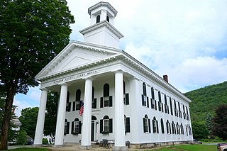
Newfane is the shire town of Windham County, Vermont, United States. The population was 1,645 at the 2020 census. The town includes the villages of Newfane, Williamsville, and South Newfane.

<span class="mw-page-title-main">Wilmington, Vermont</span> Town in Vermont, United States

Wilmington is a town in Windham County, Vermont, United States. The population was 2,255 at the 2020 census.

References

  1. 1 2 "U.S. Census website". United States Census Bureau . Retrieved 2008-01-31.
  2. "US Board on Geographic Names". United States Geological Survey. 2007-10-25. Retrieved 2008-01-31.
  3. "Census - Geography Profile: Dover town, Windham County, Vermont" . Retrieved December 29, 2021.
  4. DeLorme (1996). Vermont Atlas & Gazetteer. Yarmouth, Maine: DeLorme. ISBN   0-89933-016-9
  5. Climate Summary for Dover, Vermont
  6. "U.S. Decennial Census". United States Census Bureau. Retrieved May 16, 2015.

Commons-logo.svg Media related to Dover, Vermont at Wikimedia Commons