
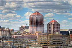
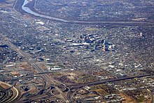
Albuquerque, also known as ABQ, Burque, and the Duke City, is the most populous city in the U.S. state of New Mexico. Founded in 1706 as La Villa de Alburquerque by Santa Fe de Nuevo México governor Francisco Cuervo y Valdés, and named in honor of Francisco Fernández de la Cueva, 10th Duke of Alburquerque and Viceroy of New Spain, it served as an outpost on El Camino Real linking Mexico City to the northernmost territories of New Spain.

Government Center station is an intermodal transit hub in the Government Center district of Downtown Miami, Florida. It is operated by Miami-Dade Transit and serves as a transfer station for the Metrorail and Metromover rapid transit systems and as a bus station for Metrobus, Paratransit, and Broward County Transit buses. MiamiCentral is directly connected via a pedestrian bridge over NW 3rd Street. The station is located near the intersection of Northwest First Street and First Avenue, a part of the Stephen P. Clark Government Center Building. It opened to service May 20, 1984, next to the site of a former FEC railway station which is now MiamiCentral.

ABQ RIDE is the local transit agency serving Albuquerque, New Mexico. ABQ RIDE operates a variety of city bus routes including two Albuquerque Rapid Transit (ART) bus rapid transit lines and a currently suspended ARTx express bus line It is the largest public transportation system in the state, serving 6,907,500 passengers in 2023, or about 21,400 per weekday as of the first quarter of 2024.

Rapid Ride was an express bus service with limited bus rapid transit (BRT) features which was operated by ABQ RIDE, the local transit agency in Albuquerque, New Mexico, from 2004 to 2020. The Rapid Ride name was phased out in 2020 with the rebranding of the one remaining Rapid Ride line as ARTx, though the service remains essentially the same.

The Alvarado Transportation Center (ATC) is a multimodal transit hub located at 100 1st Street SW in Downtown Albuquerque, New Mexico. The complex was built as a hub for Albuquerque's regional transit system and as a replacement for Albuquerque's previous bus depot and train station. The center serves ABQ RIDE, Amtrak, Greyhound Lines, and the New Mexico Rail Runner Express commuter rail line.

Downtown Spokane or Riverside is the central business district of Spokane, Washington. The Riverside neighborhood is roughly bounded by I-90 to the south, Division Street to the east, Monroe Street to the west and Boone Avenue to the north. The topography of Downtown Spokane is mostly flat except for areas downstream of the Spokane Falls which are located in a canyon; the elevation is approximately 1,900 feet (580 m) above sea level.
Central Avenue is a major east–west street in Albuquerque, New Mexico, which historically served as the city's main thoroughfare and principal axis of development. It runs through many of Albuquerque's oldest neighborhoods, including Downtown, Old Town, Nob Hill, and the University of New Mexico area. Central Avenue was part of U.S. Route 66 from 1937 until the highway's decommissioning in 1985 and also forms one axis of Albuquerque's house numbering system. It was also signed as Business Loop 40 until the early 1990s when ownership of Central Avenue was transferred from the New Mexico State Highway Department to the City of Albuquerque.

South Downtown is a historic neighborhood of Downtown Atlanta, Georgia, United States. South Downtown is primarily home to city, county, state, and federal governmental offices, which prompted the city to adopt signage declaring the area "Government Walk." Although much of South Downtown is dominated by surface parking lots, the neighborhood was passed over during the redevelopment boom of the 1960s and 1970s that resulted in the demolition of much of Downtown's architecturally significant buildings. The result is myriad buildings from the 1950s and earlier that retain their historic structural integrity.

Barelas is an inner-city neighborhood of Albuquerque, New Mexico, located immediately south of Downtown. It consists of the triangular area bounded by Coal Avenue, the BNSF railroad tracks, and the Rio Grande. Originally a separate village, it was absorbed into Albuquerque during the railroad-fueled growth of the 1880s but still retains a distinct identity. The settlement was formally established in 1662, predating even Old Town as the oldest neighborhood in the city. Although it was long one of Albuquerque's most economically distressed areas, Barelas has seen significant development since the opening of the National Hispanic Cultural Center in 2000 and may be starting to experience gentrification.

Nob Hill is a neighborhood in Albuquerque, New Mexico, United States, consisting of a commercial district along Central Avenue and surrounding residential areas. Located just east of the University of New Mexico, the neighborhood was developed between about 1925 and 1950 and has since become a popular tourist and shopping destination. Known for its eclectic mix of mostly locally owned businesses, Nob Hill has been described as "the heart of Albuquerque's Route 66 culture and also its hippest, funkiest retail and entertainment district". The neighborhood is named after Nob Hill in San Francisco, California.

Downtown Minot is the central business district of Minot, North Dakota, located south of the Souris River in the Souris Valley. Downtown is the site of the first permanent settlement in Minot in 1886. Downtown is home to many of Minot's cultural sites of interest. It is also home to numerous galleries, stores and restaurants. The Minot Riverwalk traverses the downtown.
The history of Albuquerque, New Mexico dates back up to 12,000 years, beginning with the presence of Paleo-Indian hunter-gatherers in the region. Gradually, these nomadic people adopted a more settled, agricultural lifestyle and began to build multi-story stone or adobe dwellings now known as pueblos by 750 CE. The Albuquerque area was settled by the Tiwa people beginning around 1250. By the 1500s, there were around 20 Tiwa pueblos along a 60-mile (97 km) stretch of the middle Rio Grande valley. The region was visited by Spanish conquistadores beginning with the expedition of Francisco Vázquez de Coronado in 1540–41, and began to be settled by Spanish colonists after the expedition of Juan de Oñate in 1598. By 1680, 17 Spanish estancias were reported along the Camino Real in the Albuquerque area.

Superior Avenue is the main wide thoroughfare and part of U.S. Route 6 in Ohio in Downtown Cleveland, the largest and most populated city of Northeast Ohio. Superior runs through the central hub of Cleveland, Public Square. However, the only traffic that can go through the square is bus, bike, and pedestrian transportation. In 2016, the city of Cleveland completed renovation of the Public Square green space and it was decided that no civilian vehicular traffic should be allowed to traverse the park area. Public Square is the "hub" because all of the main streets in downtown jut out from this central greenery. To the east and west, Superior, to the north and south Ontario Street as all the north–south roads are Streets in Cleveland (which goes back to the 1906 Street Plan Decision, and diagonally to the southwest, Euclid Avenue.

The International District is a neighborhood in southeast Albuquerque, New Mexico. It is centered on Central Avenue, the historic alignment of U.S. Route 66, and contains the New Mexico State Fairgrounds. The community is one of the most diverse areas of the city and is home to a large number of international restaurants and grocery stores, as well as the city's "Little Saigon" Vietnamese enclave. It is also one of the poorest areas in the city and has an extremely high violent crime rate. Although re-branded by city officials as the International District in 2009, Albuquerque residents continue to refer to the neighborhood by its longtime nickname, The War Zone.

Martineztown-Santa Barbara is a neighborhood in central Albuquerque, New Mexico, immediately northeast of Downtown. Originating as a small farming village in the 1850s, it is one of the city's oldest neighborhoods and retains a distinct character, with winding streets, irregular lots, and adobe vernacular buildings reminiscent of other old Hispanic communities in northern New Mexico.

Huning Highlands, also known as EDo or East Downtown, is an inner-city neighborhood in Albuquerque, New Mexico, directly east of Downtown. It is a mostly residential area known for its high concentration of Victorian and early 20th-century houses and is listed on the National Register of Historic Places as the Huning Highlands Historic District. There is also a commercial district along the main thoroughfares, Central Avenue and Broadway Boulevard. Huning Highlands was developed starting in 1880 and is named for Franz Huning, a prominent businessman at the time.

South Broadway is an inner-city neighborhood in Albuquerque, New Mexico, located southeast of Downtown. The neighborhood developed between the 1890s and early 1900s and has a housing stock consisting mainly of smaller Victorian homes and bungalows. It was historically a diverse working-class neighborhood and the center of the city's African American community. Along with other New Mexican cities such as Clovis and Hobbs, the neighborhood is one of the centers of Black American culture and history in New Mexico.
San Jose is a neighborhood in southern Albuquerque, New Mexico. It was originally a separate village but was absorbed into the city in the 20th century. San Jose was first settled as a Hispanic farming community in the mid-1800s but transitioned to a working-class urban neighborhood after the arrival of the railroad in 1880. The neighborhood includes a mix of residential and industrial properties with a commercial district centered on Broadway Boulevard.

The Downtown Neighborhood is a neighborhood in Albuquerque, New Mexico, located between Downtown and Old Town. It is sometimes known as the Fourth Ward based on Albuquerque's former system of political wards. The neighborhood is a mostly residential area consisting largely of single-family dwellings in various sizes and styles constructed between the 1880s and 1940s. There is also a commercial district along Central Avenue which has been branded since 2017 as West Downtown.

Emerson/Garfield is a neighborhood in Spokane, Washington. It is located immediately north of Downtown Spokane's North Bank and extends out into the inner northwestern portion of the city. Emerson/Garfield is a diverse neighborhood with residential, commercial and civic zones all bordering one another, with density ranging from single-family homes to multi-use buildings. Due to its location in the central area of Spokane, Emerson/Garfield is criss-crossed by numerous arterials and thoroughfares. Along those main roads are numerous commercial and retail districts of importance to both the neighborhood and city as a whole.


