Drummond, Idaho

Last updated

Drummond, Idaho
Fremont County Idaho Incorporated and Unincorporated areas Drummond Highlighted 1622780.svg
Location of Drummond in Fremont County, Idaho.
Coordinates: 43°59′57″N111°20′38″W / 43.99917°N 111.34389°W / 43.99917; -111.34389
Country United States
State Idaho
County Fremont
Area
[1]
  Total0.10 sq mi (0.25 km2)
  Land0.10 sq mi (0.25 km2)
  Water0.00 sq mi (0.00 km2)
Elevation
5,610 ft (1,710 m)
Population
 (2010) [2]
  Total16
  Estimate 
(2019) [3]
16
  Density166.67/sq mi (64.03/km2)
Time zone UTC-7 (Mountain (MST))
  Summer (DST) UTC-6 (MDT)
ZIP code
83420
Area code 208
FIPS code 16-22780
GNIS feature ID0380768

Drummond is a city in Fremont County, Idaho, United States. The population was 16 at the 2010 census. It is part of the Rexburg, Idaho Micropolitan Statistical Area.

Contents

Geography

Drummond is located at 43°59′57″N111°20′38″W / 43.99917°N 111.34389°W / 43.99917; -111.34389 (43.999147, -111.343769). [4]

According to the United States Census Bureau, the city has a total area of 0.10 square miles (0.26 km2), all of it land. [5]

Drummond is east of U.S. Highway 20 on State Highway 32.

Climate

According to the Köppen climate classification, Drummond has a warm-summer humid continental climate (Köppen climate classification: Dfb).

Climate data for Drummond, Idaho 1991–2020 simulated normals (5591 ft elevation)
MonthJanFebMarAprMayJunJulAugSepOctNovDecYear
Average high °F (°C)28.8
(−1.8)
32.9
(0.5)
42.3
(5.7)
52.2
(11.2)
62.6
(17.0)
71.1
(21.7)
81.3
(27.4)
81.1
(27.3)
71.1
(21.7)
55.8
(13.2)
40.1
(4.5)
29.3
(−1.5)
54.0
(12.2)
Daily mean °F (°C)19.6
(−6.9)
22.8
(−5.1)
31.3
(−0.4)
39.9
(4.4)
49.1
(9.5)
56.5
(13.6)
64.2
(17.9)
63.1
(17.3)
54.7
(12.6)
42.4
(5.8)
29.8
(−1.2)
20.3
(−6.5)
41.1
(5.1)
Average low °F (°C)10.4
(−12.0)
12.7
(−10.7)
20.5
(−6.4)
27.7
(−2.4)
35.6
(2.0)
41.9
(5.5)
47.1
(8.4)
45.3
(7.4)
38.1
(3.4)
29.1
(−1.6)
19.6
(−6.9)
11.3
(−11.5)
28.3
(−2.1)
Average precipitation inches (mm)2.09
(53.07)
1.54
(39.00)
1.61
(41.02)
1.90
(48.22)
2.32
(58.99)
1.85
(47.02)
0.78
(19.75)
0.90
(22.87)
1.35
(34.22)
1.74
(44.14)
1.66
(42.06)
2.29
(58.09)
20.03
(508.45)
Average dew point °F (°C)15.3
(−9.3)
16.5
(−8.6)
21.6
(−5.8)
25.3
(−3.7)
32.4
(0.2)
38.5
(3.6)
40.8
(4.9)
38.1
(3.4)
32.7
(0.4)
27.1
(−2.7)
21.2
(−6.0)
15.4
(−9.2)
27.1
(−2.7)
Source: Prism Climate Group [6]

Demographics

Historical population
CensusPop.Note
1920 115
1930 61−47.0%
1940 668.2%
1950 59−10.6%
1960 31−47.5%
1970 13−58.1%
1980 2592.3%
1990 3748.0%
2000 15−59.5%
2010 166.7%
2019 (est.)16 [3] 0.0%
U.S. Decennial Census [7]

2010 census

As of the census [2] of 2010, there were 16 people, 8 households, and 3 families residing in the city. The population density was 160.0 inhabitants per square mile (61.8/km2). There were 10 housing units at an average density of 100.0 per square mile (38.6/km2). The racial makeup of the city was 93.8% White and 6.3% from two or more races.

There were 8 households, of which 12.5% had children under the age of 18 living with them, 37.5% were married couples living together, and 62.5% were non-families. 50.0% of all households were made up of individuals, and 37.5% had someone living alone who was 65 years of age or older. The average household size was 2.00 and the average family size was 3.33.

The median age in the city was 51.5 years. 18.7% of residents were under the age of 18; 0.1% were between the ages of 18 and 24; 25.1% were from 25 to 44; 18.8% were from 45 to 64; and 37.5% were 65 years of age or older. The gender makeup of the city was 50.0% male and 50.0% female.

2000 census

As of the census [8] of 2000, there were 15 people, 7 households, and 3 families residing in the city. The population density was 139.9 inhabitants per square mile (54.0/km2). There were 12 housing units at an average density of 111.9 per square mile (43.2/km2). The racial makeup of the city was 100.00% White. Hispanic or Latino of any race were 6.67% of the population.

There were 7 households, out of which none had children under the age of 18 living with them, 28.6% were married couples living together, 14.3% had a female householder with no husband present, and 57.1% were non-families. 42.9% of all households were made up of individuals, and none had someone living alone who was 65 years of age or older. The average household size was 2.14 and the average family size was 3.00.

In the city, the population was spread out, with 6.7% under the age of 18, 20.0% from 18 to 24, 33.3% from 25 to 44, 26.7% from 45 to 64, and 13.3% who were 65 years of age or older. The median age was 42 years. For every 100 females, there were 114.3 males. For every 100 females age 18 and over, there were 133.3 males.

The median income for a household in the city was $12,500, and the median income for a family was $52,917. Males had a median income of $36,250 versus $0 for females. The per capita income for the city was $15,164. There were no families and 35.7% of the population living below the poverty line, including no under eighteens and none of those over 64.

See also

Related Research Articles

<span class="mw-page-title-main">Teton County, Idaho</span> County in Idaho, United States

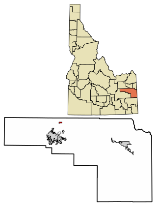
Teton County is a county located in the U.S. state of Idaho. As of the 2020 census, the population was 11,630. The county seat is Driggs, and the largest city is Victor. The county was established in 1915 and was named after the Teton Mountains to the east.

<span class="mw-page-title-main">Fremont County, Idaho</span> County in Idaho, United States

Fremont County is a county located in the U.S. state of Idaho. As of the 2020 census the county had a population of 13,388. The county seat and largest city is St. Anthony. The county was established in 1893, and was named for the explorer John C. Frémont. Fremont County is part of the Rexburg, Idaho micropolitan area, which is also included in the Idaho Falls metropolitan area.

<span class="mw-page-title-main">McCammon, Idaho</span> City in Idaho, United States

McCammon is a city in Bannock County, Idaho, United States. It is part of the Pocatello, Idaho Metropolitan Statistical Area'. The population was 809 at the 2010 census. In 1892, McCammon became the junction point between the Oregon Short Line Railroad and Utah and Northern Railway, and city gained the nickname Junction City.

<span class="mw-page-title-main">Plummer, Idaho</span> City in Idaho, United States

Plummer is a city in Benewah County, Idaho, United States. The population was 1,044 at the 2010 census, up from 990 in 2000. It is the largest city within the Coeur d'Alene Reservation, and is accessed by U.S. Route 95, the state's primary north–south highway.

<span class="mw-page-title-main">Carey, Idaho</span> City in Idaho, United States

Carey is a city in Blaine County, Idaho, United States. The population was 604 at the 2010 census. Carey is primarily an agricultural city and is the location of the Blaine County Fairgrounds. Nearby recreational destinations include the Craters of the Moon National Monument, Carey Lake, Silver Creek and the Little Wood River. Further west is the Big Wood River Valley, leading to the Sun Valley resort. In recent years, the city of Carey has experienced significant growth.

<span class="mw-page-title-main">Crouch, Idaho</span> City in Idaho, United States

Crouch is a city in Boise County, Idaho, United States. The population was 162 at the 2010 census. It is part of the Boise City–Nampa, Idaho Metropolitan Statistical Area. In 2018, it has multiple commercial businesses for tourists and residents: a small grocery mart, a hardware store, three restaurants, a bar, The Starlight Mountain Theater, and a community thrift store. At that time, the construction of the Banks/Lowman road 2512A, The "Wildlife Canyon Scenic Byway highway, transformed a small unpaved road unto a paved modern road between Crouch and Lowman. Now it is a fully modern paved roadway with informational and white water rafting pull outs which serves to transport tourists, rafters, commuters, and other traffic across the middle Idaho region.

<span class="mw-page-title-main">Ammon, Idaho</span> City in Idaho, United States

Ammon is a suburb city in Bonneville County, Idaho, United States. As of the 2010 US Census, the population of Ammon was 13,816. By the 2020 census, Ammon's population had grown to 17,694. It lies directly to the east of Idaho Falls and to the west of the Ammon foothills, and is the second most populous city in the Idaho Falls metropolitan area.

<span class="mw-page-title-main">Iona, Idaho</span> City in Idaho, United States

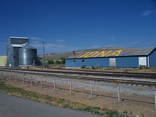
Iona is a city in Bonneville County, Idaho, United States. It is part of the Idaho Falls, Idaho Metropolitan Statistical Area. The population was 1,803 at the 2010 census.

<span class="mw-page-title-main">Irwin, Idaho</span> City in Idaho, United States

Irwin is a city in Bonneville County, Idaho, United States. It is part of the Idaho Falls, Idaho Metropolitan Statistical Area. The population was 219 at the 2010 census.

<span class="mw-page-title-main">Swan Valley, Idaho</span> City in Idaho, United States

Swan Valley is a city in Bonneville County, Idaho, United States. It is part of the Idaho Falls, Idaho Metropolitan Statistical Area. The population was 204 at the 2010 census.

<span class="mw-page-title-main">Ucon, Idaho</span> City in Idaho, United States

Ucon is a city in Bonneville County, Idaho, United States. It is part of the Idaho Falls, Idaho Metropolitan Statistical Area. The population was 1,108 at the 2010 census. Ucon was first settled in 1883.

<span class="mw-page-title-main">Bancroft, Idaho</span> City in Caribou County, Idaho, United States

Bancroft is a city in the Gem Valley in Caribou County, Idaho, United States. The population was 377 at the 2010 census.

<span class="mw-page-title-main">Mountain Home, Idaho</span> City in Idaho, United States

Mountain Home is the largest city and county seat of Elmore County, Idaho, United States. The population was 15,979 in the 2020 census. Mountain Home is the principal city of the Mountain Home, Idaho Micropolitan Statistical Area, which includes Elmore County.

<span class="mw-page-title-main">Franklin, Idaho</span> City in Idaho, United States

Franklin is a city in Franklin County, Idaho, United States. The population was 641 at the 2010 census. It is part of the Logan, Utah-Idaho Metropolitan Statistical Area.

<span class="mw-page-title-main">Parker, Idaho</span> City in Idaho, United States

Parker is a city in southeastern Fremont County, Idaho, United States. The population was 305 at the 2010 census. It is part of the Rexburg, Idaho Micropolitan Statistical Area.

<span class="mw-page-title-main">Teton, Idaho</span> City in Idaho, United States

Teton is a city in Fremont County, Idaho, United States. The population was 735 at the 2010 census. It is part of the Rexburg, Idaho Micropolitan Statistical Area.

<span class="mw-page-title-main">Tetonia, Idaho</span> City in Idaho, United States

Tetonia is a city in Teton County, Idaho, United States, about 50 miles (80 km) northeast of Idaho Falls, Idaho and about 425 miles (684 km) northwest of Denver, Colorado. The population was 269 at the 2010 census.

<span class="mw-page-title-main">Victor, Idaho</span> City in Idaho, United States

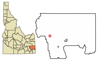
Victor is the largest city in Teton County, Idaho, United States. The population was 2,157 at the 2020 census, up from 1,928 in 2010, and 840 from 2000. It is part of the Jackson, WY–ID Micropolitan Statistical Area.

<span class="mw-page-title-main">Buhl, Idaho</span> City in Twin Falls, Idaho, United States

Buhl is a city located on the old Oregon Trail in the western half of Twin Falls County, Idaho. The population was 4,122 at the time of the 2010 census, up from 3,985 in 2000. It is part of the Twin Falls, Idaho metropolitan area.

<span class="mw-page-title-main">Hopkinton, Iowa</span> City in Iowa, United States

Hopkinton is a city in Delaware County, Iowa, United States. The population was 622 at the time of the 2020 census.

References

  1. "2019 U.S. Gazetteer Files". United States Census Bureau. Retrieved July 9, 2020.
  2. 1 2 "U.S. Census website". United States Census Bureau . Retrieved December 18, 2012.
  3. 1 2 "Population and Housing Unit Estimates". United States Census Bureau. May 24, 2020. Retrieved May 27, 2020.
  4. "US Gazetteer files: 2010, 2000, and 1990". United States Census Bureau. February 12, 2011. Retrieved April 23, 2011.
  5. "US Gazetteer files 2010". United States Census Bureau. Archived from the original on July 2, 2012. Retrieved December 18, 2012.
  6. "PRISM Climate Group at Oregon State University". Northwest Alliance for Computational Science & Engineering (NACSE), based at Oregon State University. Retrieved March 13, 2023.
  7. "Census of Population and Housing". Census.gov. Retrieved June 4, 2015.
  8. "U.S. Census website". United States Census Bureau . Retrieved January 31, 2008.

Commons-logo.svg Media related to Drummond, Idaho at Wikimedia Commons