This article includes a list of references, related reading or external links, but its sources remain unclear because it lacks inline citations .(May 2021) |
Dume district was an administrative unit in Cameroon during the German colonial rule.
This article includes a list of references, related reading or external links, but its sources remain unclear because it lacks inline citations .(May 2021) |
Dume district was an administrative unit in Cameroon during the German colonial rule.
The district area, which was in the range of today's province of Est, bordered on the west by the Yaoundé district, in the east by the French border. In the north of the Sanaga River (Lom) formed the boundary against the residency Adamawa, after 1913 residency Ngaoundéré. In the western part of the district, the Nyong was the southern border area against the Lomié District. In the south, the district also bordered the 1911 newly created district Molundu.
The area was inhabited primarily by Bantu peoples, especially Omvang, Makaa and Kaka as well as the Ubangi-speaking Gbaya. In the 1909 census, the total population amounted to 97,566 residents. Political centers of the indigenous population were Gamane/Bertua (Gbaya), Baturi, Mokbe, Bimba and Beri (Kaka).
The development of the region by the colonial power began in 1897 with the expedition of Lieutenant Ernst von Carnap-Quernheimb in the Sanga-Ngoko area. In 1899 Regierungsrat (Senior Executive Officer) Dr. Plehn began in the southeastern tip of the colony with the establishment of the management of the Sanga-Ngoko district. In 1901-1903 Ludwig Freiherr von Stein Lausnitz undertook extensive expeditions in the Makaa, Gbaya Kaka and Territory and commenced in August 1902 with the disempowerment of the Bertua Chief and his replacement by his loyal son the integration into the German power structure of the area between Doume and the Sanaga River.
In 1906-07 there was a major armed conflict between the German protection force and the Omvang and Makaa in the region between the Sanaga, Dja and Doume. As a result, the transition area between forest and savanna between the 4th and 6 Latitude was removed from the Sanga-Ngoko Administration (District Lomi) and became independent. On Doume River was a fort which was named Dume, which was the county seat and location of the 9th Company of the protection force. Due to its location at the terminus of the navigability of the river, the place soon became the crossroads of important trade routes.
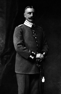
The First Administrative Officer of the district was Captain Peter Scheunemann, who was soon succeeded by Captain Adolf Schipper (* 12. Nov. 1875; † Nov. 4, 1915 in Cameroon). The troops forced the further pacification and development of the district area. After the killing of a German businessman, once again in May–July 1910 it came to a military conflict. The cause of the escalation of violence were the actions of the German and African traders, including attacks on the indigenous societies in the wake of the expansion of the rubber trade, but also the recruitment of the indigenes for control works and road construction, dam construction and river cleaning in the Doume. Within weeks, the riots were suppressed under the direction of Captain Hans Dominik. In 1913 the former Military District had been transformed into a civilian district. In 1916 the district came under the administration of the French, who moved the district headquarters to Bertoua.
This article needs additional or more specific categories .(May 2021) |
At the crossroads of West Africa and Central Africa, the territory of what is now Cameroon has seen human habitation since some time in the Middle Paleolithic, likely no later than 130,000 years ago. The earliest discovered archaeological evidence of humans dates from around 30,000 years ago at Shum Laka. The Bamenda highlands in western Cameroon near the border with Nigeria are the most likely origin for the Bantu peoples, whose language and culture came to dominate most of central and southern Africa between 1000 BCE and 1000 CE.

Kamerun was an African colony of the German Empire from 1884 to 1916 in the region of today's Republic of Cameroon. Kamerun also included northern parts of Gabon and the Congo with western parts of the Central African Republic, southwestern parts of Chad and far eastern parts of Nigeria.
The German colonial empire constituted the overseas colonies, dependencies and territories of Imperial Germany. Unified in the early 1870s, the chancellor of this time period was Otto von Bismarck. Short-lived attempts at colonization by individual German states had occurred in preceding centuries, but crucial colonial efforts only began in 1884 with the Scramble for Africa. Claiming much of the left-over uncolonized areas of Africa, Germany built the third-largest colonial empire at the time, after the British and French. The German Colonial Empire encompassed parts of several African countries, including parts of present-day Burundi, Rwanda, Tanzania, Namibia, Cameroon, Gabon, Congo, Central African Republic, Chad, Nigeria, Togo, Ghana, New Guinea and numerous other West Pacific / Micronesian islands.
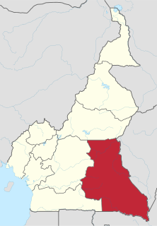
The East Region occupies the southeastern portion of the Republic of Cameroon. It is bordered to the east by the Central African Republic, to the south by Congo, to the north by the Adamawa Region, and to the west by the Centre and South Regions. With 109,002 km² of territory, it is the largest region in the nation as well as the most sparsely populated. Historically, the peoples of the East have been settled in Cameroonian territory for longer than any other of the country's many ethnic groups, the first inhabitants being the Baka pygmies.

The South Region is located in the southwestern and south-central portion of the Republic of Cameroon. It is bordered to the east by the East Region, to the north by the Centre Region, to the northwest by the Littoral Region, to the west by the Gulf of Guinea, and to the south by the countries of Equatorial Guinea, Gabon, and Congo. The South occupies 47,720 km2 of territory, making it the fourth largest region in the nation. The major ethnic groups are the various Beti-Pahuin peoples, such as the Ewondo, Fang, and Bulu.

The Centre Region occupies 69,000 km² of the central plains of the Republic of Cameroon. It is bordered to the north by the Adamawa Region, to the south by the South Region, to the east by the East Region, and to the West by the Littoral and West Regions. It is the second largest of Cameroon's regions in land area. Major ethnic groups include the Bassa, Ewondo, and Vute.

The Adamawa Region is a constituent region of the Republic of Cameroon. It borders the Centre and East regions to the south, the Northwest and West regions to the southwest, Nigeria to the west, the Central African Republic (CAR) to the east, and the North Region to the north.
German West Africa (Deutsch-Westafrika) was an informal designation for the areas in West Africa that were part of the German Colonial Empire between 1884 and 1919. The term was normally used for the territories of Cameroon and Togo. German West Africa was not an administrative unit. However, in trade and in the vernacular the term was sometimes in use.
Hans Dominik was a German colonial officer of the Schutztruppe. He was the long-time commander of the Jaunde military station in Kamerun.

Neukamerun was the name of Central African territories ceded by the Third French Republic to the German Empire in 1911. Upon taking office in 1907, Theodor Seitz, governor of Kamerun, advocated the acquisition of territories from the French Congo. Germany's only major river outlet from its Central African possessions was the Congo River, and more territories to the east of Kamerun would allow for better access to that waterway.
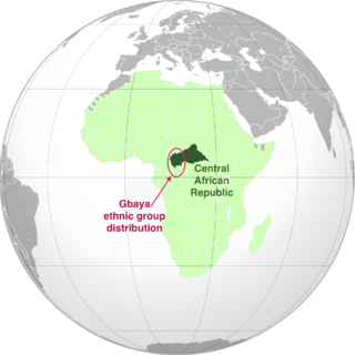
The Gbaya, also Gbeya or Baya, are a people of western region of Central African Republic, east-central Cameroon, the north of the Republic of Congo, and the northwest of the Democratic Republic of Congo. In the first half of the 20th century, the Gbaya were involved in several revolt attempts against German and then French colonial rule.
Kako is a Bantu language spoken mainly in Cameroon, with some speakers in the Central African Republic and the Republic of the Congo. The main population centres of Kako speakers are Batouri and Ndélélé in the East Region of Cameroon.

The Adamawa Wars (1899-1907) were initially a series of military expeditions and border conflicts between the German Schutztruppe in Kamerun and the Fula Sunni Muslim states and tribes that were a part of the Sokoto Empire, particularly the Emirate of Adamawa in the northern half of the region. After these territories were annexed major resistance continued for years and several uprisings occurred.
Ober-Logone was located in the Neukamerun administrative district of the German colony of Kamerun. In the modern day, its territory belongs mainly to the Republic of Chad.
Ossidinge was a government station and capital of the prefecture in the German colony of Cameroon.

Eugen Ritter von Zimmerer was an attorney, prosecutor and judge in Bavaria before he entered the colonial service in 1887 when he was in his 40s. He served in German colonies of Kamerun and Togo before being appointed as governor of Kamerun, serving between 1890 and 1893. Following that, Zimmerer was assigned to posts in Brazil, Chile and Haiti before retiring and returning to Germany.

Jantzen & Thormählen was a German firm based in Hamburg that was established to exploit the resources of Cameroon. The firm's commercial and political influence was a major factor in the establishment of the colony of Kamerun in 1884.
Bangando and Ngombe constitute a Gbaya language of Cameroon and CAR.

The Kamerun campaign took place in the German colony of Kamerun in the African theatre of the First World War when the British, French and Belgians invaded the German colony from August 1914 to March 1916. Most of the campaign took place in Kamerun but skirmishes also broke out in British Nigeria. By the Spring of 1916, following Allied victories, the majority of German troops and the civil administration fled to the neighbouring neutral colony of Spanish Guinea. The campaign ended in a defeat for Germany and the partition of its former colony between France and Britain.
During the Battle of Banjo or Battle of Banyo, British forces besieged German forces entrenched on the Banjo mountain from 4 to 6 November 1915 during the Kamerun campaign of the First World War. By 6 November much of the German force had deserted, while the rest surrendered. The battle resulted in victory for the Allies and breakdown of German resistance in northern Kamerun.