
Camden County is a county located in the southeastern corner of the U.S. state of Georgia. According to the 2020 census, its population was 54,768. Its county seat is Woodbine, and the largest city is Kingsland. It is one of the original counties of Georgia, created February 5, 1777. It is the 11th-largest county in the state of Georgia by area, and the 41st-largest by population.
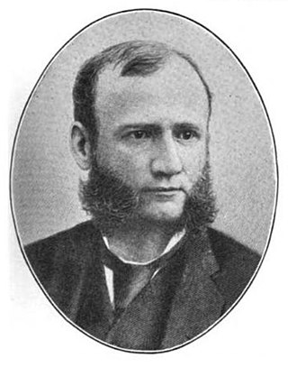
Thomas Morrison Carnegie was a Scottish-born American industrialist. He was the brother of steel magnate Andrew Carnegie and co-founder of the Edgar Thomson Steel Works.
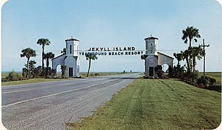
Jekyll Island is located off the coast of the U.S. state of Georgia, in Glynn County. It is one of the Sea Islands and one of the Golden Isles of Georgia barrier islands. The island is owned by the State of Georgia and run by a self-sustaining, self-governing body.

Plum Orchard is an estate located in the middle of the western shore of Cumberland Island, Georgia, USA. The estate and surrounding area are listed on the National Register of Historic Places.

Cumberland Island, in the southeastern United States, is the largest of the Sea Islands of Georgia. The long-staple Sea Island cotton was first grown here by a local family, the Millers, who helped Eli Whitney develop the cotton gin. With its unusual range of wildlife, the island has been declared a National Seashore. Little Cumberland Island is connected to the main island by a marsh.
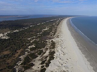
Cumberland Island National Seashore preserves most of Cumberland Island in Camden County, Georgia, the largest of Georgia's Golden Isles. The seashore features beaches and dunes, marshes, and freshwater lakes. The national seashore also preserves and interprets many historic sites and structures.

The Judah P. Benjamin Confederate Memorial at Gamble Plantation Historic State Park, also known as the Gamble Mansion or Gamble Plantation, is a Florida State Park, located in Ellenton, Florida, on 37th Avenue East and US 301. It is home to the Florida Division United Daughters of the Confederacy (UDC).

The Wallace House is a Georgian style historic house, which served as the headquarters of General George Washington during the second Middlebrook encampment (1778–79), located at 38 Washington Place, Somerville, Somerset County, New Jersey, United States. It was added to the National Register of Historic Places on December 2, 1970.
Dungeness is a headland in Kent, England.
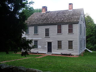
The General Nathanael Greene Homestead, also known as Spell Hall, is a historic house at 50 Taft Street in Coventry, Rhode Island. It was the home of American Revolutionary War general Nathanael Greene from 1770 to 1776, and was owned afterwards by his brother Jacob Greene and his wife Margaret. The house is owned and operated by the General Nathanael Greene Homestead Association, a non-profit organization, and was opened as a museum in 1924.
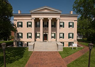
Georgia's Old Governor's Mansion is a historic house museum located on the campus of Georgia College & State University (GCSU) at 120 South Clarke Street in Milledgeville, Georgia. Built in 1839, it is one of the finest examples of Greek Revival architecture in the American South, and was designated a National Historic Landmark for its architecture in 1973. It served as Georgia's executive mansion from 1839- 1868, and has from 1889 been a university property, serving for a time as its official president's residence. It is an accredited museum of the American Alliance of Museums and in 2015 was named an affiliate of the Smithsonian Institution.

Meadow Garden is a historic house museum at 1320 Independence Drive in Augusta, Georgia. It was a home of Founding Father George Walton (1749–1804), one of Georgia's three signers of the U.S. Declaration of Independence. Walton was later elected governor of Georgia and also served as a United States senator. Meadow Garden was saved by the Daughters of the American Revolution, who established it as a museum in 1901. The house was declared a National Historic Landmark in 1981.

The Stafford Plantation was a plantation on Cumberland Island in Camden County, on the southeastern coast of Georgia. It was established in the early 19th century by Robert Stafford.

The Battle of Fort Point Peter was a successful attack in early 1815 by a British force on a smaller American force on the Georgia side of the St. Marys River near St. Marys, Georgia. The river was then part of the international border between the United States and British-allied Spanish Florida; it now forms part of the boundary between Georgia and Florida. Occupying coastal Camden County allowed the British to blockade American transportation on the Intracoastal Waterway. The attack on Forts St. Tammany and Peter occurred in January 1815, after the signing of the Treaty of Ghent, which would end the War of 1812, but before the treaty's ratification. The attack occurred at the same time as the siege of Fort St. Philip in Louisiana and was part of the British occupation of St. Marys and Cumberland Island.

Major General Nathanael Greene is a bronze equestrian statue honoring Nathanael Greene, a military leader during the American Revolutionary War. Greene was from modern-day Rhode Island and after laws passed by the Kingdom of Great Britain, along with the burning of one of his ships, Greene formed a state militia. He was later promoted to brigadier general in the Continental Army where he became a trusted adviser to Commander-in-Chief General George Washington. Greene played an active role during the war, participating in battles, sieges, and campaigns from New England to the Southern Colonies. For his service to the war, Greene was offered free land and settled in Georgia with his family. He died a few years later from a heatstroke.

City of Camden Historic District is a national historic district located at Camden, Kershaw County, South Carolina. The district encompasses 48 contributing buildings, 8 contributing sites, 2 contributing structures, and 3 contributing objects in Camden. The district is mostly residential but also include public buildings, a church, and a cemetery. Camden's architecture is classically inspired and includes examples of Federal, Greek Revival, and Classical Revival, in addition to cottage-type, Georgian, Charleston-type with modifications, and mansion-type houses. Several of the city's buildings were designed by architect Robert Mills. Notable buildings include the Kershaw County Courthouse (1826), U.S. Post Office, Camden Opera House and Clock Tower, Camden Powder Magazine, Trinity United Methodist Church, St. Mary's Catholic Church, Gov. Fletcher House, Greenleaf Villa, The First National Bank of Camden, and the separately listed Bethesda Presbyterian Church and Kendall Mill.

The Callawassie Sugar Works is a historically significant industrial site at 29 Sugar Mill Drive in Okatie, South Carolina, on Callawassie Island in Beaufort County. The site contains the tabby ruins of two structures and archeological evidence of a third structure. The sugar works, constructed circa 1815–1818, was a complex for processing sugar cane into sugar.

Greyfield is an estate with a Colonial Revival-style house of the same name on Cumberland Island in Camden County, Georgia; it was listed on the National Register of Historic Places in 2003. The inn is also a member of Historic Hotels of America, the official program of the National Trust for Historic Preservation.

The Van Horne House is a historic building at 941 East Main Street near Bound Brook in Bridgewater Township, Somerset County, New Jersey. The house was built c. 1750 and also known as Phil's Hill, after its owner, Philip Van Horne. It served as the headquarters for American General Benjamin Lincoln in 1777, during the American Revolutionary War, in particular the Battle of Bound Brook. Later, it served as the headquarters for American General William Alexander, Lord Stirling during the second Middlebrook encampment (1778–79). The house, on the early-18th-century Old York Road that connected Philadelphia to New York City, was a New Jersey landmark during the war. Since 2002, the Heritage Trail Association has used the house as its headquarters, including an exhibit space. It was added to the National Register of Historic Places on March 8, 2002, for its locally significant Colonial Revival architecture from 1937 to 1944.

Lucy Carnegie Ricketson Ferguson was a member of the American industrialist Carnegie family who spent much of her life working to conserve Cumberland Island, the largest part of which was declared a national seashore in 1972. A granddaughter of Thomas Carnegie, her family once owned 90 percent of the island.


