Durbin, North Dakota

Last updated

Durbin is an unincorporated community in Cass County, in the U.S. state of North Dakota. [1]

Cass County, North Dakota U.S. county in North Dakota

Cass County is a county in the U.S. state of North Dakota. As of the 2010 United States Census, the population was 149,778, and was estimated to be 181,516 in 2018. Cass County is the most populous county in North Dakota, accounting for nearly 23% of the state's population in 2018. Its county seat is Fargo, the most populous city in the state.

U.S. state constituent political entity of the United States

In the United States, a state is a constituent political entity, of which there are currently 50. Bound together in a political union, each state holds governmental jurisdiction over a separate and defined geographic territory and shares its sovereignty with the federal government. Due to this shared sovereignty, Americans are citizens both of the federal republic and of the state in which they reside. State citizenship and residency are flexible, and no government approval is required to move between states, except for persons restricted by certain types of court orders.

North Dakota U.S. state in the United States

North Dakota is a U.S. state in the midwestern and northern regions of the United States. It is the nineteenth largest in area, the fourth smallest by population, and the fourth most sparsely populated of the 50 states. North Dakota was admitted to the Union on November 2, 1889, along with its neighboring state, South Dakota. Its capital is Bismarck, and its largest city is Fargo.

History

Durbin was founded in 1881, and given the name of a railroad worker. [2] A post office was established at Durbin in 1881, and remained in operation until 1985. [3]

Related Research Articles

Traill County, North Dakota U.S. county in North Dakota

Traill County is a county in the U.S. state of North Dakota. As of the 2010 United States Census listed the population at 8,121. Its county seat is Hillsboro, and its largest city is Mayville.

Steele County, North Dakota U.S. county in North Dakota

Steele County is a county in the U.S. state of North Dakota. As of the 2010 United States Census, the population was 1,975. Its county seat since 1919 is Finley.

Ransom County, North Dakota U.S. county in North Dakota

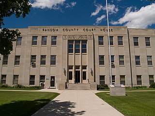
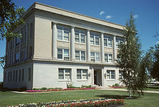
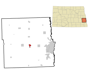
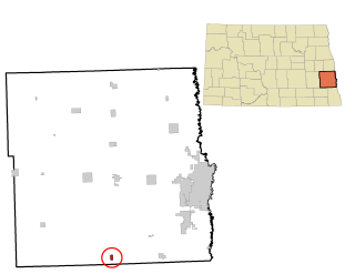
Ransom County is a county in the U.S. state of North Dakota. As of the 2010 United States Census, the population was 5,457. Its county seat is Lisbon.

Argusville, North Dakota City in North Dakota, United States

Argusville is a city in Cass County, North Dakota, United States. The population was 475 at the 2010 census, increasing from 147 a decade earlier due to a huge housing boom from 2004 to 2008. Argusville was founded in 1881.

Casselton, North Dakota City in North Dakota, United States

Casselton is a city in Cass County, North Dakota, United States. The population was 2,329 at the 2010 census. making it the twentieth largest city in North Dakota. Casselton was founded in 1876. The city is named in honor of George Washington Cass, a president of the Northern Pacific Railway, which established a station there in 1876 to develop a town for homesteaders. Casselton is the hometown of five North Dakota governors.

Davenport, North Dakota City in North Dakota, United States

Davenport is a city in Cass County, North Dakota, United States. The population was 252 at the 2010 census. Davenport was founded in 1882.

Kindred, North Dakota City in North Dakota, United States

Kindred is a city in Cass County, North Dakota, United States. The population was 692 at the 2010 census. Kindred primarily serves as a bedroom community for Fargo, located about 30 miles to the northeast.

Leonard, North Dakota City in North Dakota, United States

Leonard is a city in Cass County, North Dakota, United States. The population was 223 at the 2010 census. Leonard was founded in 1881.

Wheatland, North Dakota Census-designated place in North Dakota, United States

Wheatland is a census-designated place (CDP) in Cass County, North Dakota in the United States. The population was 68 at the 2010 census.

Pittsburgh is an unincorporated community in Pembina County, North Dakota in the United States.

KZTK country music radio station in Arthur, North Dakota, United States

KZTK, known as 103.9 The Truck, is a radio station serving the Cass County, North Dakota that airs a country music format. They are licensed to Arthur, North Dakota with studios in Casselton, North Dakota can be received in the Fargo-Moorhead Arbitron market (#209).

Absaraka, North Dakota Unincorporated community in North Dakota, United States

Absaraka is an unincorporated community in central Cass County, North Dakota, United States. It lies northwest of the city of Fargo, the county seat of Cass County. Its elevation is 1,070 feet (326 m), and it is located at 46°58′41″N97°23′40″W.

Holden Township is a defunct civil township in Adams County, North Dakota, USA. The 1990 census recorded a population of 44.

Alta Township is a civil township in Barnes County, North Dakota, USA. As of the 2000 census, its population was 98. The township is named after Alta Ridge, a moraine belt overlooking the Sheyenne River Valley.

Lanark, Texas human settlement in Texas, United States of America

Lanark is an unincorporated community in Cass County, Texas, 2 miles from Queen City. Lanark was started in 1870 when a railroad went through the town. A post office existed from 1873-77. In 2000, the population was 30.

Crandon is an unincorporated community in Spink County, in the U.S. state of South Dakota.

Esmond is an unincorporated community in Kingsbury County, in the U.S. state of South Dakota.

Arthur Township is a civil township in Cass County, in the U.S. state of North Dakota.

Gardar is an unincorporated community in Pembina County, in the U.S. state of North Dakota.

References

  1. U.S. Geological Survey Geographic Names Information System: Durbin, North Dakota
  2. Hoheisel, Tim; Nielsen, Andrew R. (2007). Cass County. Arcadia Publishing. p. 82. ISBN   978-0-7385-4145-7.
  3. "Cass County". Jim Forte Postal History. Archived from the original on 22 November 2015. Retrieved 24 October 2015.

Coordinates: 46°48′31″N97°08′58″W / 46.80861°N 97.14944°W / 46.80861; -97.14944

Geographic coordinate system Coordinate system

A geographic coordinate system is a coordinate system that enables every location on Earth to be specified by a set of numbers, letters or symbols. The coordinates are often chosen such that one of the numbers represents a vertical position and two or three of the numbers represent a horizontal position; alternatively, a geographic position may be expressed in a combined three-dimensional Cartesian vector. A common choice of coordinates is latitude, longitude and elevation. To specify a location on a plane requires a map projection.